Oakland (Pittsburgh)

Last updated
Oakland
Oakland.jpg
The University of Pittsburgh's Cathedral of Learning (right) dominates Oakland's skyline.
Pgh locator oakland.svg
Location within the city of Pittsburgh
Country United States
State Pennsylvania
County Allegheny
City Pittsburgh
Area
[1]
  Total1.50 sq mi (3.9 km2)
Elevation
[2]
1,037 ft (316 m)
Population
 (2010) [1]
  Total22,210
  Density14,800/sq mi (5,700/km2)
Time zone UTC-5 (Eastern (EST))
  Summer (DST) UTC-4 (EDT)
GNIS feature ID 1182822

Oakland is the academic and healthcare center of Pittsburgh and one of the city's major cultural centers. Home to three universities, museums, hospitals, shopping venues, restaurants, and recreational activities, this section of the city also includes two city-designated historic districts: the mostly residential Schenley Farms Historic District and the predominantly institutional Oakland Civic Center Historic District, as well as the locally-designated Oakland Square Historic District.

Contents

In addition, the Pittsburgh Bureau of Fire operates Fire Station No. 14 on McKee Place and Fire Station No. 10 on Allequippa Street.

Neighborhoods

North Oakland
Pgh locator north oakland.svg
Area
[1]
  Total0.499 sq mi (1.29 km2)
Population
 (2010) [1]
  Total10,551
  Density21,000/sq mi (8,200/km2)
Central Oakland
Pgh locator central oakland.svg
Area
[1]
  Total0.281 sq mi (0.73 km2)
Population
 (2010) [1]
  Total6,086
  Density22,000/sq mi (8,400/km2)
South Oakland
Pgh locator south oakland.svg
Area
[1]
  Total0.508 sq mi (1.32 km2)
Population
 (2010) [1]
  Total2,969
  Density5,800/sq mi (2,300/km2)
West Oakland
Pgh locator west oakland.svg
Area
[1]
  Total0.215 sq mi (0.56 km2)
Population
 (2010) [1]
  Total2,604
  Density12,000/sq mi (4,700/km2)

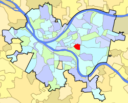
Oakland is officially divided into four neighborhoods: North Oakland, West Oakland, Central Oakland, and South Oakland. Each section has a unique identity, and offers its own flavor of venues and housing. Oakland is Pittsburgh's second most populated neighborhood with 22,210 residents, a majority of these residents being students. Scattered amongst Oakland's four neighborhoods are 29 distinct flights of city steps – many of which are open and in a safe condition. These Steps of Pittsburgh quickly connect pedestrians to public transportation and provide an easy way to travel through this densely populated area. [3] As of 2020, two of these public stairways, Joncaire Street (Central Oakland) and Louisa Street (West Oakland), also contain runnels which allow cyclists to easily transport a bike up or down the flight.

Historical population
YearPop.±%
1940 25,843    
1950 28,430+10.0%
1960 23,806−16.3%
1970 22,702−4.6%
1980 21,157−6.8%
1990 21,548+1.8%
2000 20,417−5.2%
2010 22,210+8.8%
[4] [5]
Source: University of Pittsburgh [6]

North Oakland

North Oakland can be loosely defined as the area of Oakland between Neville and Bouquet Streets, encompassing all of Craig Street and running north to Polish Hill. The Cathedral of Learning, the engineering or midsection of the University of Pittsburgh campus, and the Craig Street business district are in North Oakland.

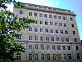
RAND's Pittsburgh center is located in North Oakland as well as the long time RIDC business incubator on Henry Street. [7] The Islamic Center of Pittsburgh, the largest mosque in the city, is located in North Oakland. [8] This sector is also home to the Schenley Farms Historic District and many mid-rise condominium and apartment buildings.

Central Oakland

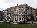
Central Oakland is bordered by Schenley Park, the Boulevard of the Allies, Fifth Avenue, and Halket Street. Many students at the University of Pittsburgh who decide to live off-campus reside in this neighborhood. Many of its homes are historic masonry structures dating from the turn of the century. The area is often confused with South Oakland. Its Main Business District runs along Forbes and Fifth Avenue, and contains a diversity of restaurants, retailers, and financial services. These businesses are organized by the Oakland Business Improvement District (OBID). Smaller business districts in Central Oakland provide additional dining options along Atwood Street and Semple Street. It is also the location of the relatively isolated and historic neighborhood of Panther Hollow which runs along Boundary Street in Junction Hollow as well as the Oakland Square Historic District.

South Oakland

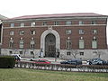
South Oakland runs along the Monongahela River and forms a triangular shape between the Monongahela River, the Boulevard of the Allies, and the western bank of Junction Hollow. Magee-Womens Hospital of UPMC and the Pittsburgh Technology Center are major landmarks of this neighborhood. The neighborhood is split between a riverfront flood plain to the southwest and a plateau to the northeast. The plateau is divided into two primarily residential areas which are separated from one another by Bates Street, which runs up a valley from the flood plain to the plateau. The residents of the neighborhood on the north side of Bates Avenue call their neighborhood Oakcliffe. The flood plain was previously packed with industrial sites such as the Pittsburgh Works Consolidated Gas Co. and the Jones & Laughlin Steel Co., [9] but presently, the Pittsburgh Technology Center hosts facilities such as the Entertainment Technology Center of Carnegie Mellon University.

Many residents of Central Oakland - as well as news outlets [10] - often consider their neighborhood part of South Oakland. However, the longstanding border between Central Oakland and South Oakland was established long ago along the Boulevard of the Allies. Forbes Avenue provides much of the neighborhood’s northern boundary.

South Oakland is reputed to be a student neighborhood, but only 36.9% of its population is between the ages of 18 and 24, compared to Central Oakland's figure of 74.1%. [11] The difference is largely because the area between Forbes Avenue and the Boulevard of the Allies houses many undergraduate students. While it is commonly considered to be in South Oakland, it is actually the heart of Central Oakland.

South Oakland was the childhood home of Andy Warhol, and later the residence of fellow pop artist Keith Haring. Haring had his first art show while living in Oakland. NFL Hall of Fame Quarterback Dan Marino was also born in Oakland, not far from Warhol's home. Dan Marino Field on Frazier Street was named in honor of its native son. Although they were not contemporaries, Warhol and Marino grew up on the same block with their former houses only a few doors apart.

West Oakland

West Oakland is bordered by Fifth Avenue in the south, DeSoto Street in the east, the Birmingham Bridge to the west, and Aliquippa Street to the north. While the smallest of the Oakland districts, the neighborhood hosts a range of commercial and residential dwellings.

Among notable commercial operations exists Carlow University and most of the University of Pittsburgh Medical Center, including UPMC Presbyterian and UPMC Montefiore.

The residential makeup is diverse and consists of a number of long-time, permanent residents living alongside students completing their undergrad and graduate degrees. Many permanent residents have called West Oakland home dating back to around 1990, when a program to incentivize first time home buyers actively brought the neighborhood to life. Entertainment and residential life has a catalyst through The Corner, which hosts social events of all kinds. Here you can find pop up art displays to jazz nights, afterschool programs, and more.

Not Oakland

Although the campus of Carnegie Mellon University and parts of Schenley Park, including Phipps Conservatory & Botanical Gardens and Flagstaff Hill are popularly referred to as being in Oakland, and are located with the 15213 zip code, they are actually part of the adjacent neighborhood of Squirrel Hill North. The border between Oakland and Squirrel Hill runs along Junction Hollow.

History

The name first appeared in 1839 in a local paper, Harris' Intelligencer. The area got its name from the abundance of oak trees found on the farm of William Eichbaum, who settled there in 1840. Oakland developed rapidly following the Great Fire of 1845 in Downtown Pittsburgh, with many people moving out to suburban territory. By 1860, there was considerable commercial development along Fifth Avenue.

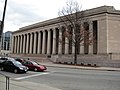
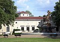
In 1868, Oakland Township, just two years after seceding from Pitt Township, was annexed to the City of Pittsburgh. [12] Twenty-one years later, Mary Schenley gave the city 300 acres in Oakland for a park. Officials bought another 100 acres from her for "Schenley Park." And Mary Schenley gave another gift: land for Schenley Plaza. At Schenley Plaza, industrialist Andrew Carnegie built a library, museum and concert hall complex, which opened in 1895.

In 1917, Teddy Roosevelt visited the neighborhood. [13]

Oakland has long been considered Pittsburgh's university center. Carnegie Mellon University is the result of a 1967 merger of the Carnegie Institute of Technology, founded in Oakland in 1900 by Andrew Carnegie, and Mellon Institute, founded in 1913 by Andrew W. and Richard B. Mellon to conduct industrial research. The University of Pittsburgh, which is heir to the Pittsburgh Academy that was incorporated in 1787, relocated to Oakland in 1909 from its campus that was then in Allegheny.

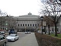
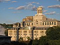
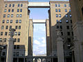
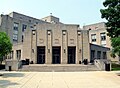
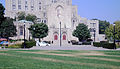
Some of the most impressive architecture in Oakland is on Pitt's campus. In 1925, work began on what was then the world's tallest educational building, the 42-story Cathedral of Learning. Although the Cathedral of Learning is now the fourth-tallest educationally purposed building in the world, it remains the world's second tallest university building, the tallest educational building in the Western Hemisphere, [14] and the second tallest gothic-styled building in the world. [15] Oakland is also home to the university's French-Gothic revival Heinz Memorial Chapel and St. Paul Cathedral, the seat of the Roman Catholic Diocese of Pittsburgh. It is also home of the main branch of the Carnegie Library, the Carnegie Museum, and Phipps Conservatory.

Baseball fans might know Oakland for the beloved Forbes Field, which was built in 1909 as the third home to the Pittsburgh Pirates and first home to the Pittsburgh Steelers. While Forbes Field was closed in 1970, some remnants of the ballpark still stand. Pirates fans gather on the site each year on the anniversary of Bill Mazeroski's World Series winning home run on October 13, 1960.

The Decade nightclub was a staple of the neighborhood in the 1970s and 1980s. [16]

Surrounding neighborhoods

North Oakland has eight borders with the Pittsburgh neighborhoods of Bloomfield to the northeast, Shadyside and Squirrel Hill North to the east, Central Oakland to the south, West Oakland to the southwest, the Terrace Village region of the Hill District to the west, the Upper Hill District to the northwest Polish Hill to the north-northwest. North Oakland also runs catty-corner (without a direct border) with Lower Lawrenceville to the north with its meeting point in the middle of the Bloomfield Bridge.

Central Oakland has five Pittsburgh neighborhood borders, including North Oakland to the north, Squirrel Hill North to the northeast, Squirrel Hill South to the east, South Oakland to the south and southwest, and West Oakland to the northwest.

South Oakland has six land borders, including the Pittsburgh neighborhoods of Central Oakland to the northeast, Squirrel Hill South to the east, Greenfield to the southeast, Hazelwood to the south-southeast, Bluff to the west, and West Oakland to the northwest. Across the Monongahela River, South Oakland runs adjacent with Pittsburgh's South Side Flats neighborhood.

West Oakland has six borders with the Pittsburgh neighborhoods of North Oakland to the northeast, Central Oakland to the southeast, South Oakland to the south and south-southeast, Bluff to the southwest, and the Crawford-Roberts and Terrace Village regions of the Hill District to the west and northwest, respectively.

Sites

Other attractions

Notable people

Oakland Viewed From Flagstaff Hill.jpg
The skyline of West, Central, and North Oakland as viewed from Flagstaff Hill

See also

Notes

  1. 1 2 3 4 5 6 7 8 9 10 11 12 13 Although adjacent to Oakland, these attractions are technically just within the official border of Squirrel Hill North although they are almost always popularly considered to be located in Oakland.

Related Research Articles

<span class="mw-page-title-main">University of Pittsburgh</span> Public university in Pittsburgh, Pennsylvania, US

The University of Pittsburgh is a public state-related research university in Pittsburgh, Pennsylvania, United States. The university is composed of 17 undergraduate and graduate schools and colleges at its urban Pittsburgh campus, home to the university's central administration and around 28,000 undergraduate and graduate students. The 132-acre Pittsburgh campus includes various historic buildings that are part of the Schenley Farms Historic District, most notably its 42-story Gothic revival centerpiece, the Cathedral of Learning. Pitt is a member of the Association of American Universities and is classified among "R1: Doctoral Universities – Very high research activity". It is the second-largest non-government employer in the Pittsburgh metropolitan area.

<span class="mw-page-title-main">Squirrel Hill</span> Neighborhood of Pittsburgh in Allegheny County, Pennsylvania, United States

Squirrel Hill is a residential neighborhood in the East End of Pittsburgh, Pennsylvania, United States. The city officially divides it into two neighborhoods, Squirrel Hill North and Squirrel Hill South, but it is almost universally treated as a single neighborhood.

<span class="mw-page-title-main">Schenley Park</span> Park in Pittsburgh, Pennsylvania

Schenley Park is a large municipal park in Pittsburgh, Pennsylvania, United States. It is located between the neighborhoods of Oakland, Greenfield, and Squirrel Hill. It is also listed on the National Register of Historic Places as a historic district. In 2011, the park was named one of "America's Coolest City Parks" by Travel + Leisure.

<span class="mw-page-title-main">Downtown Pittsburgh</span> Neighborhood in Allegheny County, Pennsylvania, United States

Downtown Pittsburgh, colloquially referred to as the Golden Triangle, and officially the Central Business District, is the urban downtown center of Pittsburgh, Pennsylvania, United States. It is located at the confluence of the Allegheny River and the Monongahela River whose joining forms the Ohio River. The triangle is bounded by the two rivers.

<span class="mw-page-title-main">Mellon Institute of Industrial Research</span> United States historic place

The Mellon Institute of Industrial Research was a research institute in Pittsburgh, Pennsylvania that became part of Carnegie Mellon University. It was founded in 1913 by Andrew Mellon and Richard B. Mellon as part of the University of Pittsburgh, and was originally located in Allen Hall. After becoming an independent research center and moving to a new building on Fifth Avenue in 1937, the Mellon Institute merged with the Carnegie Institute of Technology in 1967 to form Carnegie Mellon University. While it ceased to exist as a distinct institution, the landmark building bearing its name remains located at the corner of Fifth Avenue and Bellefield Avenue in Oakland, the city's university district. It is sited adjacent to The Carnegie Mellon Software Engineering Institute (SEI) and the University of Pittsburgh's Bellefield Hall and is across Bellefield Avenue from two other local landmarks: the University of Pittsburgh's Heinz Memorial Chapel and the Cathedral of Learning.

<span class="mw-page-title-main">Highland Park (Pittsburgh neighborhood)</span> Neighborhood of Pittsburgh in Allegheny County, Pennsylvania, United States

Highland Park is a neighborhood in the northeastern part of Pittsburgh, Pennsylvania. Highland Park, the neighborhood, fully encompasses the park with the same name.

<span class="mw-page-title-main">Swisshelm Park</span> Neighborhood of Pittsburgh in Allegheny County, Pennsylvania, United States

Swisshelm Park is a neighborhood located in the southeast corner of Pittsburgh, Pennsylvania. It is represented on the Pittsburgh City Council by Barbara Warwick. Swisshelm Park houses PBF 19 Engine, and is covered by PBP Zone 4 and the Bureau of EMS Medic 7.

<span class="mw-page-title-main">Point Breeze, Pittsburgh</span> Neighborhood of Pittsburgh in Allegheny County, Pennsylvania, United States

Point Breeze, or South Point Breeze, is a largely residential neighborhood in Pittsburgh, Pennsylvania, USA. The community was named after a tavern once located there.

The culture of Pittsburgh stems from the city's long history as a center for cultural philanthropy, as well as its rich ethnic traditions. In the 19th and 20th centuries, wealthy businessmen such as Andrew Carnegie, Henry J. Heinz, Henry Clay Frick, and nonprofit organizations such as the Carnegie Foundation donated millions of dollars to create educational and cultural institutions.

<span class="mw-page-title-main">Boulevard of the Allies</span> Major road in Pittsburgh, US

The Boulevard of the Allies is a mostly four-lane road in the U.S. state of Pennsylvania, connecting Downtown Pittsburgh with the Oakland neighborhood of the city. Because of its lengthy name, locals sometimes refer to it as simply "The Boulevard".

<span class="mw-page-title-main">Junction Hollow</span>

Junction Hollow is a small wooded valley bordering the west flanks of Schenley Park and the campus of Carnegie Mellon University and the southern edge of the University of Pittsburgh's campus in Pittsburgh, Pennsylvania.

<span class="mw-page-title-main">Schenley Quadrangle</span> Residence halls at the University of Pittsburgh

Schenley Quadrangle is a cluster of University of Pittsburgh ("Pitt") residence halls that is a Pittsburgh History and Landmarks Foundation Historic Landmark and are contributing properties to the Schenley Farms National Historic District in Pittsburgh, Pennsylvania, United States.

<span class="mw-page-title-main">Fifth Avenue (Pittsburgh)</span>

Fifth Avenue is one of the longest streets in Pittsburgh, Pennsylvania, United States. It begins downtown and moves eastward for over five miles (9 km). Fifth Avenue passes by the Carlow University, the Cathedral of Learning and other buildings of the University of Pittsburgh, then forms the borders between Shadyside on the north and Squirrel Hill and Point Breeze to the south. Finally, after passing Chatham University, The Ellis School, and Mellon Park, it turns north and forms the border between Larimer on the west and North Point Breeze and Homewood (Pittsburgh) on the east. At the intersection with Frankstown Avenue its name becomes Washington Boulevard and descends a branch of Negley Run to meet Allegheny River Boulevard near the Highland Park Bridge.

<span class="mw-page-title-main">Forbes Avenue</span>

Forbes Avenue is one of the longest streets in Pittsburgh, Pennsylvania, United States. It runs along an east–west route for a length of approximately 7 mi (11 km).

<span class="mw-page-title-main">Schenley Farms Historic District</span> Historic district in Pennsylvania, United States

The Schenley Farms Historic District, also referred to as the Schenley Farms–Oakland Civic District, is a historic district listed on the National Register of Historic Places that is located in the Oakland section of Pittsburgh, Pennsylvania, United States.

Franklin Felix Nicola (1860–1938) was an American real estate developer.

<span class="mw-page-title-main">Longfellow, Alden & Harlow</span>

Longfellow, Alden & Harlow, of Boston, Massachusetts, and Pittsburgh, Pennsylvania, was the architectural firm of Alexander Wadsworth Longfellow Jr. (1854–1934), Frank Ellis Alden (1859–1908), and Alfred Branch Harlow (1857–1927). The firm, successors to H. H. Richardson, continued to provide structures in the Romanesque revival style established by Richardson that is often referred to as Richardsonian Romanesque.

<span class="mw-page-title-main">Oakland Square Historic District</span>

Oakland Square Historic District in the Central Oakland neighborhood of Pittsburgh, Pennsylvania, contains 99 properties. The core of the district surrounds Oakland Square, with the remaining properties along Parkview Avenue and Dawson Street. The neighborhood was conceived in the 1890s by developer Eugene O'Neill and were inspired by the urban design of Victorian England and Dublin. The district was added to the List of City of Pittsburgh historic designations on June 14, 2005.

Edward Stotz Sr. (1868–1948) was an American architect who was based in the city of Pittsburgh in the Commonwealth of Pennsylvania. He designed numerous buildings during the late nineteenth and early twentieth centuries that are now listed as significant by the National Register of Historic Places and the Pittsburgh History and Landmarks Foundation.

References

  1. 1 2 3 4 5 6 7 8 9 10 "PGHSNAP 2010 Raw Census Data by Neighborhood". Pittsburgh Department of City Planning. 2012. Retrieved 21 June 2013.
  2. "Oakland". Geographic Names Information System . United States Geological Survey, United States Department of the Interior . Retrieved July 15, 2022.
  3. Regan, Bob (2015). Pittsburgh Steps, The Story of the City's Public Stairways. Globe Pequot. ISBN   978-1-4930-1384-5.
  4. "PGHSNAP – Neighborhoods: All Raw Data". Google Docs.
  5. "Census:Pittsburgh" (PDF). Archived from the original (PDF) on August 10, 2007. Retrieved 2 September 2012.
  6. "Pittsburgh Census Tracts". pitt.libguides.com. Retrieved January 2, 2018.
  7. Wilhelm, Kathy (July 25, 1985), "Incubators help hatch new firms", Pittsburgh Post-Gazette, Pittsburgh, PA
  8. Iati, Marisa (September 25, 2014). "Muslims in Islamic Center of Pittsburgh demonstrate little-known facets of their faith". Pittsburgh Post-Gazette . Retrieved October 31, 2018.
  9. "Real estate plat-book of the city of Pittsburgh : from official records, private plans and actual surveys, Volume 1. Plate 15". G. M. Hopkins & Co. 1904. Retrieved 19 October 2011.
  10. O'Neill, Brian (11 December 2011). "Can Pitt get SOUL (i.e., South Oakland Urban Litter)?". Pittsburgh Post-Gazette . Retrieved 11 December 2011.
  11. CITY OF PITTSBURGH NEIGHBORHOOD PROFILES AMERICAN COMMUNITY SURVEY FIVE‐YEAR ESTIMATES 2005‐2009 DATA (PDF). PROGRAM IN URBAN AND REGIONAL ANALYSIS, UNIVERSITY CENTER FOR SOCIAL AND URBAN RESEARCH, UNIVERSITY OF PITTSBURGH. June 2011. Retrieved 11 June 2011.
  12. Negley, W. B. (1876). "Allegheny County; its Formation, its Cities, Wards, Boroughs and Townships". Atlas of the County of Allegheny, Penna. Philadelphia: G.M. Hopkins & Co. p. 4.
  13. "Teddy Roosevelt giving a speech in Pittsburgh | the Brady Stewart Collection".
  14. "Moscow State University, Moscow, Russia". Emporis . Archived from the original on April 6, 2004. Retrieved 2 August 2010.
  15. "Cathedral of Learning, Pittsburgh". SkyscraperPage.com. Retrieved 2012-12-07.
  16. "The Pittsburgh Press – Google News Archive Search". news.google.com.
  17. "St. George Orthodox Church |". www.sgcoakland.org. Retrieved 2022-07-11.

40°26′28″N79°57′25″W / 40.441°N 79.957°W / 40.441; -79.957