
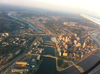
Downtown Pittsburgh, colloquially referred to as the Golden Triangle, and officially the Central Business District, is the urban downtown center of Pittsburgh, Pennsylvania, United States. It is located at the confluence of the Allegheny River and the Monongahela River whose joining forms the Ohio River. The triangle is bounded by the two rivers.

Charles/MGH station is a rapid transit station on the MBTA Red Line, elevated above Charles Circle on the east end of the Longfellow Bridge in the West End neighborhood of Boston, Massachusetts. The station is named for Charles Circle and the adjacent Massachusetts General Hospital (MGH) campus. It has two side platforms, with a glass-walled headhouse structure inside Charles Circle. Charles/MGH station is fully accessible.
Highland Park is a neighborhood in the northeastern part of Pittsburgh, Pennsylvania. Highland Park, the neighborhood, fully encompasses the park with the same name.

Brookline is a neighborhood in the South Hills of Pittsburgh, Pennsylvania, United States. It takes its name from the town in Massachusetts, which early settlers felt bore a resemblance to the area.

Uptown or The Bluff is a neighborhood in the city of Pittsburgh, Pennsylvania to the southeast of the city's Central Business District. It is bordered in the north by the Hill District and located across the Monongahela River from South Side. The predominant area zip code is 15219.

Allegheny Center is a neighborhood on Pittsburgh's North Side. Its zip code is 15212, and it has representation on Pittsburgh City Council by both council members for District 6 and District 1 (Northside).

Allentown is a neighborhood located in southern portion of the city of Pittsburgh, Allegheny County, Pennsylvania. The ZIP code used by residents is 15210, and has representation on the Pittsburgh City Council by the council member for District 3.

Arlington Heights is a neighborhood in the southern portion of Pittsburgh, Pennsylvania. The zip code used by residents is 15210, and this neighborhood is represented on the Pittsburgh City Council by the council member for District 3. This neighborhood is home to five government housing projects.

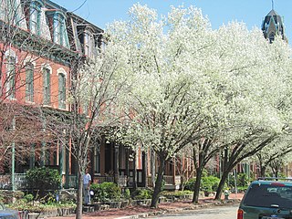
The South Side Flats is a neighborhood in Pittsburgh, Pennsylvania's South Side area. It is located just south of the Monongahela River. The neighborhood has one of the City of Pittsburgh's largest concentrations of 19th-century homes, which has prompted outsiders to call the neighborhood the City's Georgetown. It includes many bars and restaurants as well as residences. The main throughway in the South Side Flats is East Carson Street. The street is home to a significant portion of Pittsburgh's nightlife.

Chateau is a North Side neighborhood in Downtown Pittsburgh, Pennsylvania. It has representation on Pittsburgh City Council by the council member for District 6. It is on the banks of the Ohio River and is separated from the neighborhood of Manchester by PA Route 65.

Fineview — known to older generations as Nunnery Hill — is a neighborhood on Pittsburgh's North Side with expansive views of downtown Pittsburgh. The most famous of these views is from the Fineview Overlook at the corner of Catoma Street and Meadville Street.
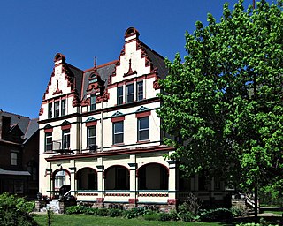
Manchester is a North Side neighborhood in Pittsburgh, Pennsylvania. The neighborhood is represented on Pittsburgh City Council by the District 6. Manchester houses PBF Battalion 1 & 37 Engine, and is covered by PBP Zone 1 and the Bureau of EMS Medic 4. The neighborhood includes the Manchester Historic District, which protects, to some degree, 609 buildings over a 51.6-acre (20.9 ha) area. The district was listed on the National Register of Historic Places in 1975. It uses ZIP code of 15233.
North Shore is a neighborhood in Pittsburgh's North Side. Its zip code is 15212.

West End Village is a neighborhood in Pittsburgh, Pennsylvania's west city area. It has a zip code of 15220, and has representation on Pittsburgh City Council by the council member for District 2.

Perry South—also known as Perry Hilltop—is a neighborhood on Pittsburgh, Pennsylvania's North Side. It developed as a streetcar suburb around the turn of the 20th century, so it consists almost exclusively of residential housing, with a small business district at the intersection of Perrysville Avenue and Charles Avenue. The hill on which the neighborhood is built provides natural borders to the west, to the east and to the south.
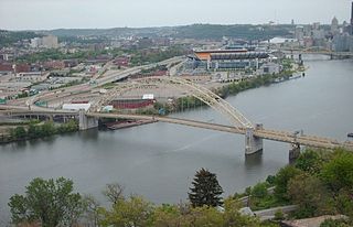
The West End Bridge is a steel tied-arch bridge over the Ohio River in Pittsburgh, Pennsylvania, approximately 1 mile (1.6 km) below the confluence of the Allegheny and Monongahela Rivers. It connects the West End to the Chateau neighborhood on the North Side of Pittsburgh.

Transportation in Pittsburgh, Pennsylvania is different than in many other major American cities. A large metropolitan area that is surrounded by rivers and hills, Pittsburgh has an infrastructure system that has been built out over the years to include roads, tunnels, bridges, railroads, inclines, bike paths, and stairways; however, the hills and rivers still form many barriers to transportation within the city.

The Pittsburgh Light Rail is a 26.2-mile (42.2 km) light rail system in Pittsburgh, Pennsylvania, and surrounding suburbs. It operates as a deep-level subway in Downtown Pittsburgh, but runs mostly at-grade in the suburbs south of the city. The system is largely linear in a north-south direction, with one terminus near Pittsburgh's central business district and two termini in the South Hills. The system is owned and operated by Pittsburgh Regional Transit. The T is one of the surviving first-generation streetcar systems in North America, with the oldest portions of the network dating back to 1903 and the Pittsburgh Railways. It is also one of only three light rail systems in the United States that continues to use the broad 5 ft 2+1⁄2 in Pennsylvania Trolley Gauge on its lines instead of the 4 ft 8+1⁄2 instandard gauge. In 2022, the system had a ridership of 2,429,500.
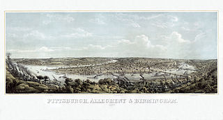
In 1763, King George III provided John Ormsby approximately 2,400 acres (9.7 km2) along the south bank of the Monongahela River as payment for his services during the French and Indian War. The land was then divided into four boroughs: South Pittsburgh, Birmingham, East Birmingham, and Ormsby. The four boroughs were annexed into the City of Pittsburgh in 1872. These areas, collectively, provided for the foundation of the South Side as it is known today.
South Side Slopes is a neighborhood in Pittsburgh, Pennsylvania's South Side area. The neighborhood comprises the hills from the South Side Flats neighborhood along the Monongahela River from the Liberty Bridge (west) to beyond Josephine Street (east).
