Panther Hollow

Last updated
Panther Hollow
Pgh locator central oakland.svg
Red pog.svg
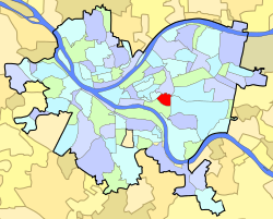
Panther Hollow
Location within Central Oakland
Coordinates: 40°26′23″N79°57′04″W / 40.43975°N 79.95108°W / 40.43975; -79.95108
Country United States
State Pennsylvania
County Allegheny County
City Pittsburgh
Neighborhood Oakland (Pittsburgh)

Panther Hollow is a small, somewhat isolated community at the bottom of Joncaire Street in Junction Hollow that runs along Boundary Street and is located in the Central Oakland neighborhood of Pittsburgh, Pennsylvania. The community was settled in late 19th century mostly by Italian immigrants from Pizzoferrato and Gamberale, Italy. Even today, park benches and picnic tables in the neighborhood are painted in the red, white, and green of the Italian flag and a sign post marks the distance to the two Italian cities from which most of the original residents arrived. Among its most famous such residents was Pittsburgh boxing legend Mose Butch. A remembrance memorial in the neighborhood, dedicated on December 2, 2007, commemorates the original 95 families that first settled in the neighborhood.

Contents

Panther Hollow sign post PantherHollowSign.jpg
Panther Hollow sign post
Panther sculpture by Moretti on Panther Hollow Bridge (Cathedral of Learning in background) Panther0658.jpg
Panther sculpture by Moretti on Panther Hollow Bridge (Cathedral of Learning in background)

See also

Related Research Articles

<span class="mw-page-title-main">Pittsburgh</span> Second-most populous city in Pennsylvania, United States

Pittsburgh is a city in the Commonwealth of Pennsylvania and the county seat of Allegheny County. It is the second-most populous city in Pennsylvania after Philadelphia and the 68th-most populous city in the U.S., with a population of 302,971 as of the 2020 census. The city anchors the Pittsburgh metropolitan area of Western Pennsylvania. Its population of 2.457 million is the largest in both the Ohio Valley and Appalachia, the second-largest in Pennsylvania, the 7th-largest in the Mid-Atlantic region and the 26th-largest in the U.S. Pittsburgh is the principal city of the greater Pittsburgh–Weirton–Steubenville combined statistical area which includes parts of Ohio and West Virginia.

<span class="mw-page-title-main">Oakland (Pittsburgh)</span> Place in Pennsylvania, United States

Oakland is the academic and healthcare center of Pittsburgh and one of the city's major cultural centers. Home to three universities, museums, hospitals, shopping venues, restaurants, and recreational activities, this section of the city also includes two city-designated historic districts: the mostly residential Schenley Farms Historic District and the predominantly institutional Oakland Civic Center Historic District, as well as the locally-designated Oakland Square Historic District.

<span class="mw-page-title-main">Schenley Park</span> Park in Pittsburgh, Pennsylvania

Schenley Park is a large municipal park in Pittsburgh, Pennsylvania, United States. It is located between the neighborhoods of Oakland, Greenfield, and Squirrel Hill. It is also listed on the National Register of Historic Places as a historic district. In 2011, the park was named one of "America's Coolest City Parks" by Travel + Leisure.

<span class="mw-page-title-main">Hazelwood (Pittsburgh)</span> Neighborhood of Pittsburgh in Allegheny County, Pennsylvania, United States

Hazelwood is a neighborhood of Pittsburgh, Pennsylvania in the United States. It is represented on Pittsburgh City Council by Barb Warwick. It is bordered by Greenfield and Oakland on the north, Squirrel Hill and Glen Hazel on the east, and the Monongahela River on the south and west. The Pittsburgh Bureau of Fire houses 13 Engine and 13 Truck in Hazelwood.

<span class="mw-page-title-main">Bloomfield (Pittsburgh)</span> Neighborhood of Pittsburgh in Allegheny County, Pennsylvania, United States

Bloomfield is a neighborhood in Pittsburgh, Pennsylvania. It is located three miles from the downtown area. Bloomfield is sometimes referred to as Pittsburgh's Little Italy because it was settled by Italians from the Abruzzi region and has been a center of Italian–American population. Pittsburgh architectural historian Franklin Toker has said that Bloomfield "is a feast, as rich to the eyes as the homemade tortellini and cannoli in its shop windows are to the stomach." Recently, the neighborhood has attracted young adults and college students as a "hip" neighborhood.

<span class="mw-page-title-main">Allegheny County belt system</span> Allegheny County belt system

The Allegheny County Belt System color codes various county roads to form a unique system of routes in Allegheny County, Pennsylvania, and around the city of Pittsburgh.

<span class="mw-page-title-main">Swisshelm Park</span> Neighborhood of Pittsburgh in Allegheny County, Pennsylvania, United States

Swisshelm Park is a neighborhood located in the southeast corner of Pittsburgh, Pennsylvania. It is represented on the Pittsburgh City Council by Barbara Warwick. Swisshelm Park houses PBF 19 Engine, and is covered by PBP Zone 4 and the Bureau of EMS Medic 7.

<span class="mw-page-title-main">West Oakland, Oakland, California</span> Neighbourhood in Oakland, California

West Oakland is a neighborhood situated in the northwestern corner of Oakland, California, United States, situated west of Downtown Oakland, south of Emeryville, and north of Alameda. The neighborhood is located along the waterfront at the Port of Oakland and at the eastern end of the San Francisco–Oakland Bay Bridge. It lies at an elevation of 13 feet.

<span class="mw-page-title-main">Troy Hill (Pittsburgh)</span> Neighborhood of Pittsburgh in Allegheny County, Pennsylvania, United States

Troy Hill is a neighborhood on Pittsburgh, Pennsylvania's North Side. It has a zip code of 15212, and has representation on Pittsburgh City Council by the council member for District 1.

<span class="mw-page-title-main">Perry South</span> Neighborhood of Pittsburgh in Allegheny County, Pennsylvania, United States

Perry South—also known as Perry Hilltop—is a neighborhood on Pittsburgh, Pennsylvania's North Side. It developed as a streetcar suburb around the turn of the 20th century, so it consists almost exclusively of residential housing, with a small business district at the intersection of Perrysville Avenue and Charles Avenue. The hill on which the neighborhood is built provides natural borders to the west, to the east and to the south.

<span class="mw-page-title-main">Boulevard of the Allies</span> Major road in Pittsburgh, US

The Boulevard of the Allies is a mostly four-lane road in the U.S. state of Pennsylvania, connecting Downtown Pittsburgh with the Oakland neighborhood of the city. Because of its lengthy name, locals sometimes refer to it as simply "The Boulevard".

<span class="mw-page-title-main">Bohemian Flats</span> City park in Minneapolis

Bohemian Flats Park is a park in Minneapolis, Minnesota, United States on the west bank of the Mississippi River near the Washington Avenue Bridge and next to the University of Minnesota campus. The area, once known as Little Bohemia, was the site of a shanty town as Minneapolis was incorporated in 1867. European immigrants seeking employment in the city or at the mills at the nearby St. Anthony Falls settled there. The former housing structures and historic buildings no longer remain. The park is managed by the Minneapolis Park and Recreation Board as part of the Mississippi Gorge Regional Park, and it lies within the Mississippi National River Recreation Area.

Four Mile Run, also known as Ruska Dolina, is a valley in the Greenfield section of Pittsburgh, Pennsylvania, United States. The small neighborhood formed around the growth of Pittsburgh's steel industry as Rusyn immigrants settled in the area for employment at the nearby steel mill in the Hazelwood neighborhood and formed St. John Chrysostom Byzantine Catholic Church.

<span class="mw-page-title-main">Junction Hollow</span>

Junction Hollow is a small wooded valley bordering the west flanks of Schenley Park and the campus of Carnegie Mellon University and the southern edge of the University of Pittsburgh's campus in Pittsburgh, Pennsylvania.

<span class="mw-page-title-main">Panther Hollow Bridge</span> Bridge in Pittsburgh, Pennsylvania

The Panther Hollow Bridge is an American steel, three-hinged, deck arch bridge that carries Panther Hollow Road over Panther Hollow in Schenley Park in Pittsburgh, Pennsylvania.

<span class="mw-page-title-main">Panthers of Pittsburgh</span> Mascot of the University of Pittsburgh

A panther is the animal that serves as the official mascot of the University of Pittsburgh and used as a nickname for both athletic teams as well as other organizations and affiliates of the university. The mascot is generally referred to as the Pittsburgh Panther or Pitt Panther, while the costumed panther mascot is also named "Roc". Up to 20 physical representations of panthers can be found in and around the university's campus and athletic facilities.

Frank S. Curto was the chief horticulturist for the Pittsburgh Department of Parks and Recreation.

<span class="mw-page-title-main">Panther Hollow (valley)</span>

Panther Hollow is a wooded valley in Pittsburgh, Pennsylvania, that runs approximately 1.5 mi (2.4 km) west to east through Schenley Park. It begins at Boundary Street in Junction Hollow and ends near Hobart Street in Squirrel Hill. Curiously, the neighborhood of Panther Hollow in Central Oakland is not actually in the valley of Panther Hollow itself, but rather in Junction Hollow.

<span class="mw-page-title-main">West Side, Chicago</span> District in Illinois, United States

The West Side is one of the three major sections of the city of Chicago, Illinois, U.S. The other two sections within Chicago that associate with the West Side are the North Side and the South Side. The West Side consists of communities that are of historical, cultural, and ideological importance to the history and development of Chicago. On the flag of Chicago, the West Side is represented by the central white stripe.

References

    Video