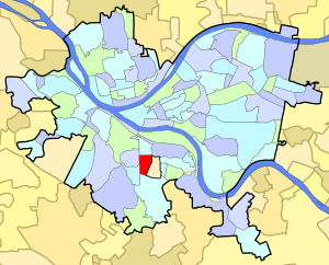
Mount Oliver is a borough in Allegheny County, Pennsylvania, United States. The population was 3,394 at the 2020 census. It is a largely residential area situated atop a crest about 3 miles (5 km) west of the Monongahela River. The borough is surrounded entirely by the city of Pittsburgh, having resisted annexation attempts by the city.

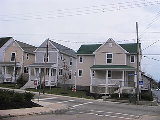
Allentown is a neighborhood located in the southern portion of the city of Pittsburgh, Pennsylvania. The ZIP code used by residents is 15210, and has representation on the Pittsburgh City Council by the council member for District 3.

Arlington is a neighborhood in southern Pittsburgh, Pennsylvania. The zip code used by residents is 15210, and the neighborhood has representation on Pittsburgh City Council by the council member for District 3. Arlington houses PBF 22 Engine, and is covered by PBP Zone 3 and the Bureau of EMS Medic 2. The City has discussed the possibility of closing 22 engine completely. 22 engine is a vital key to second and third alarm firefighting in the city.

The South Side Flats is a neighborhood in Pittsburgh, Pennsylvania's South Side area. It is located just south of the Monongahela River. The neighborhood has one of the City of Pittsburgh's largest concentrations of 19th-century homes, which has prompted outsiders to call the neighborhood the City's Georgetown. It includes many bars and restaurants as well as residences. The main throughway in the South Side Flats is East Carson Street. The street is home to a significant portion of Pittsburgh's nightlife.

Carrick is a south neighborhood of Pittsburgh, Pennsylvania in the United States. It is served by two zip codes, 15210 and 15227, and has representation on Pittsburgh City Council by the council member for District 4 with a part in District 3.

Bon Air is a neighborhood in the south portion of Pittsburgh, Pennsylvania, United States. Its two zip codes are 15226 and 15210, and it is represented in the Pittsburgh City Council by the council member for District 4.
Beltzhoover is a neighborhood in southern Pittsburgh, Pennsylvania, in an area known as the South Hills.
Carrick High School is a public school in the Carrick neighborhood of Pittsburgh.
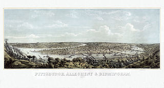
In 1763, King George III provided John Ormsby approximately 2,400 acres (9.7 km2) along the south bank of the Monongahela River as payment for his services during the French and Indian War. The land was then divided into four boroughs: South Pittsburgh, Birmingham, East Birmingham, and Ormsby. The four boroughs were annexed into the City of Pittsburgh in 1872. These areas, collectively, provided for the foundation of the South Side as it is known today.
St. Clair Township, Allegheny County, Pennsylvania, was one of the original townships created with the incorporation of Allegheny County in 1788. The township was named after Arthur St. Clair, an American Revolutionary War general and president of the Continental Congress in 1787.

St. Clair is a neighborhood in Pittsburgh, Pennsylvania in the United States. The neighborhood was the last remnant of Lower St. Clair Township to be annexed by the City of Pittsburgh in 1920.

The Knoxville Incline was a broad gauge inclined railway that ran between Pittsburgh's South Side and Allentown neighborhoods. The incline was built in 1890 and had a track gauge of 9 feet (2,700 mm).
The Keeling Coal Company (1861–1878) was a 19th-century coal mining company in Allegheny County, Pennsylvania. Its mines were located in the Pittsburgh Coalfield of western Pennsylvania.

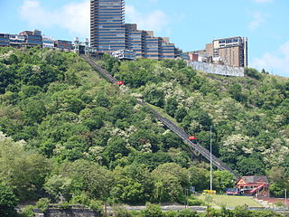
The Mount Oliver Incline was a funicular on the South Side of Pittsburgh, Pennsylvania. It was designed in 1871 by the Prussian-born engineer John Endres and his American daughter Caroline Endres, one of the first women engineers in the United States.
The Pittsburgh and Castle Shannon Tunnel, also known as the Mount Washington Coal Tunnel, was a 3 ft 4 in narrow-gauge railway tunnel under Mt. Washington.
South Side Park is an urban park in Pittsburgh. It is situated in a ravine that divides the South Side Slopes neighborhood, and extends to the location of the former Oliver Ormsby estate in Mount Oliver, Pennsylvania, Ormsby Manor.
Pittsburgh, Knoxville & St. Clair Electric Railroad was one of the earliest electric street railways. A licensee of the Daft System, the line struggled with difficult terrain, required expensive bridges, and failed financially within just 3 years of opening.
Mount Washington is a neighborhood in the southern region of Pittsburgh, Pennsylvania. It has a Zip Code of 15211 and has representation on Pittsburgh City Council by both the council members for District 3 and District 2.

The Pittsburgh Reporter is an American online newspaper based in Pittsburgh, Pennsylvania. Founded in 1939 as a weekly newspaper, it evolved into a daily online platform with a focusing on regional news and community issues.