Monongahela or Mon Valley may refer to:

The Johnstown Inclined Plane is a 896.5-foot (273.3 m) funicular in Johnstown, Cambria County in the U.S. state of Pennsylvania. The incline and its two stations connect the city of Johnstown, situated in a valley at the confluence of the Stonycreek and the Little Conemaugh Rivers, to the borough of Westmont on Yoder Hill. The Johnstown Inclined Plane is billed as the "world's steepest vehicular inclined plane", as it is capable of carrying automobiles, in addition to passengers, up or down a slope with a grade of 70.9 percent. The travel time from one station to the other is 90 seconds.

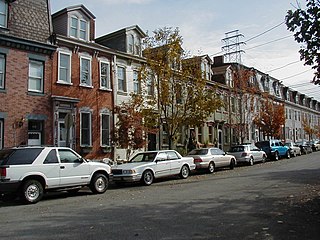
Fineview is a neighborhood on Pittsburgh, Pennsylvania's North Side. It has zip codes of both 15212 and 15214, and has representation on Pittsburgh City Council by the council member for District 6 and District 1. Fineview was known to older generations as Nunnery Hill. Its modern name derives from the expansive views of downtown Pittsburgh. The most famous of these views is from the Fineview Overlook at the corner of Catoma and Meadville streets.

Knoxville is a neighborhood in southern Pittsburgh, Pennsylvania. It is part of zip code 15210, and has representation on Pittsburgh City Council by the council member for District 3.

The Duquesne Incline is a funicular located near Pittsburgh's South Side neighborhood and scaling Mt. Washington in Pennsylvania, United States. Designed by Samuel Diescher, the incline was completed in 1877 and is 800 feet (244 m) long, 400 feet (122 m) in height, and is inclined at a 30-degree angle. It is an unusual track gauge of 5 ft.

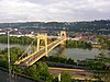
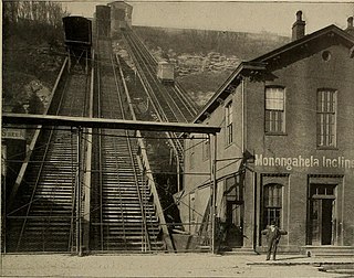
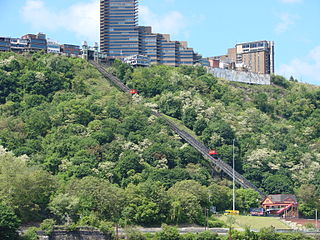
The Monongahela Incline is a funicular located near the Smithfield Street Bridge in Pittsburgh, Pennsylvania. Built by John Endres in 1870, it is the oldest continuously operating funicular in the United States. It is also one of two surviving inclines from the original 17 passenger-carrying inclines built in Pittsburgh starting in the late 19th century. Its lower station is across the street from the Station Square shopping complex, and is easily accessible from the light rail system at the Station Square station.
The Castle Shannon Incline was a funicular railroad in Pittsburgh, Pennsylvania. It was originally part of the Pittsburgh and Castle Shannon Railroad route to the suburb of Castle Shannon. It replaced an earlier incline dating to 1825 that brought coal down from a mine in Mount Washington. Initially opened on 26 August 1890, the incline operated for only a few days before breaking down, the original machinery being unable to bear the strain of the large freight and passenger cars. After a second abortive run in October, it was decided that the machinery had to be replaced. The refitted incline opened on 7 March 1891. It ran from Bailey Avenue west of Haberman Avenue down to Carson Street just west of Arlington Avenue.
The Clifton Incline was a funicular that operated from 1889 to 1905 in what is now the Perry Hilltop neighborhood of Pittsburgh, Pennsylvania. It extended from its base at Sarah Street at the intersection with Myrtle Street to its top landing at Clifton Park near the end of Clifton Street.

The Fort Pitt Incline was a 10 ft gauge funicular railroad in the Bluff neighborhood of Pittsburgh. Opened in 1882, the incline ran from 2nd Avenue to Bluff Street, a distance of 350 feet (107 m), and a vertical distance of 135 feet (41 m). The designer was Samuel Diescher.
Caroline Endres Diescher was the daughter of the Prussian-born engineer John Endres. She was one of the first female engineers in the United States, and with her father, designed two inclines in the Pittsburgh area: the Monongahela Incline and the Mount Oliver Incline. She married another engineer, Samuel Diescher, at the St. Paul German Evangelical Church in Cincinnati, Ohio. They had three sons, all of whom were engineers.

The Nunnery Hill Incline was a funicular in Allegheny City, Pennsylvania, in what is now the Fineview neighborhood of Pittsburgh. Designed by Samuel Diescher, it operated from 1888 until 1895 between its base station on Federal Street to its upper station on the currently named Meadville Street. It was one of a few inclines with a curve in the track. The name of the hill derived from a short-lived settlement of Poor Clares earlier in the century.
The St. Clair Incline, also known as the South Twenty-second Street Incline, was built in 1886–1888 and operated by St. Clair Incline Plane Company. It was a double track incline on the South Side Slopes of Pittsburgh from Josephine St. to Salisbury St. The lower station was near the intersection of S. 22nd Street and Josephine. The upper station was on Salisbury Street across from the former Fort Laughlin site eventually occupied by Arlington Playground. The incline was 2,060 ft (628 m) long, with a vertical rise of 361 ft (110 m). It was designed by engineer J. H. McRoberts. As it carried both freight and passengers over steep tracks laid on the ground, it could be considered to be a cable railway. Its path was not of constant slope but became progressively steeper toward the top, tracing a parabolic arc. It is uncertain exactly when the incline closed permanently, but it was reported as shut down in a 1932 Associated Press article about the "passing" of Pittsburgh's inclines. The structure was dismantled in 1934.
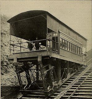
The Monongahela Freight Incline was a funicular railway that scaled Mount Washington in Pittsburgh, Pennsylvania, United States.
The Norwood Incline was a funicular railway located just outside Pittsburgh, Pennsylvania, United States. It operated from 1901 to 1923 between its lower station on Island Avenue, McKees Rocks, and its upper station in Norwood Place, Stowe Township. Originally free to ride, it got the nickname "Penny Incline" after it started charging a one-cent fare. Its two narrow-gauge tracks were formed by only three rails, the middle rail being shared by both tracks, except at mid-slope where the tracks separated to allow the upbound and downbound cars to pass each other.

The Troy Hill Incline, also known as the Mount Troy Incline, was a funicular railway located in old Allegheny, Pennsylvania, which is now the North Side of the city of Pittsburgh. Built by Gustav Lindenthal or Samuel Diescher, the incline was one of only a few funiculars constructed on the north side of Pittsburgh. It began construction in August 1887, and after considerable delay, opened on 20 September 1888. The incline ascended from Ohio Street near the end of the second 30th Street Bridge to Lowrie Street on the crest of Troy Hill. Never very profitable, it shut down in fall 1898 and was razed a decade later. A building now standing at 1733 Lowrie Street was long thought to have been the summit station, but later research found that the building did not appear on maps until well after the incline closed. The incline's length measured 370 feet (113 m), with a forty-seven percent (47%) gradient. The cost of construction was about $94,047.

The Penn Incline, also known as the 17th Street Incline, was a funicular railroad in Pittsburgh, Pennsylvania, in operation from 1884 to 1953. It ascended from 17th Street between Liberty and Penn avenues in the Strip District to Arcena (Ridgeway) Street near Ledlie Street in the Hill District.
The Ridgewood Incline was an inclined plane railroad in Allegheny City, Pennsylvania, in what is now the Perry South neighborhood of Pittsburgh. Built in 1886 and burned the next year, it was Allegheny's first and shortest-lived incline.
Mount Washington is a neighborhood in Pittsburgh, Pennsylvania's south city area. It has a zip code of 15211 and has representation on Pittsburgh City Council by both the council members for District 3 and District 2.