California-Kirkbride (Pittsburgh)

Last updated
California-Kirkbride
OldAlleghenyRowsHistoricDistrict.jpg
Pgh locator california kirkbride.svg
Coordinates: 40°27′40″N80°01′23″W / 40.461°N 80.023°W / 40.461; -80.023
Country United States
State Pennsylvania
County Allegheny County
City Pittsburgh
Area
  Total0.217 sq mi (0.56 km2)
Population
 (2010) [1]
  Total761
  Density3,500/sq mi (1,400/km2)
ZIP Code
15233, 15212
Saint Ives Street city steps in California Kirkbride, Pittsburgh. Photo by Laura Zurowski. Saint Ives Street city steps California Kirkbride Pittsburgh.jpg
Saint Ives Street city steps in California Kirkbride, Pittsburgh. Photo by Laura Zurowski.

California-Kirkbride is a neighborhood on Pittsburgh, Pennsylvania's North Side.

Contents

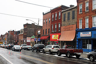
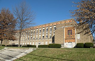
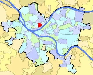
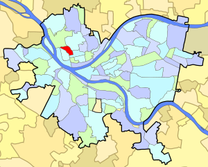
The neighborhood consists of a wedge of land between the railroad tracks at the northern edge of Manchester and a steep hill at the southern edges of Brightwood and Perry Hilltop. Put differently, the neighborhood is bounded by California and Allegheny Avenues on the West; by Pennsylvania Avenue on the South; by Brighton Road on the East; and by Island Avenue on the North. [2] A former rail yard, now home to a United States Postal Service sorting facility, occupies most of the southern border, and Oliver High School, a high school in the Pittsburgh Public Schools system, is located just north of the neighborhood's northern border at Island Avenue.

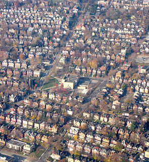
Most of the neighborhood is located on the flat river plain that comprises the majority of old Allegheny City. The neighborhood developed along with Manchester and, according to a 1974 profile by Pittsburgh's Department of Planning, would likely be considered part of Manchester but for the railroad tracks that form a border between Manchester and California-Kirkbride. [3] That profile states that: "Historically, this area had been part of Manchester but due to the barrier imposed by the railroad, it did not receive the industrial uses typical of Manchester except on its borders. However, it was effected by the racial shift in population which increased from about 3% Black in 1960 to about 35% in the 1970 census."

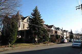
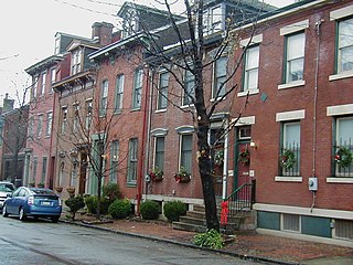
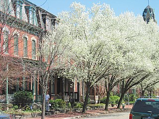
The neighborhood was developed almost exclusively between 1870 and 1900. During this period, industries including tanneries, slaughterhouses, and the local rail yard were flourishing in Allegheny City, and the men working in these industries needed housing for themselves and their families. To meet this need, several businessmen - often the owners of the businesses whose workers needed housing - bought land in California-Kirkbride and built rowhouses on it. The neighborhood thus consists almost entirely of rowhouses that were initially built for industrial workers and their families. A significant portion of the neighborhood's rowhouses were listed on the National Register of Historic Places in 1984, as the Old Allegheny Rows Historic District. [4] As the petition nominating the district for National Register status explained, these rowhouses, while intended for industrial workers of modest means, were designed to be beautiful and to offer the workers some amenities: "The various styles and designs of row houses in the proposed Old Allegheny Rows Historic District represent the local evolution of row housing between 1870-1900. The growth of industry and manufacturing, advances and improvements in transportation, and a growing urban working class, increased the demand for housing in what had been a remote corner of the City of Allegheny. This era saw a change in the nature and appearance of city dwellings in the district from simple brick boxes intended to house the workers of a particular local industry, to an ornate polychromed speculative development with modern conveniences designed to appeal to the independent urban wage earner."

The neighborhood began to depopulate after the Great Depression. The neighborhood's demographics also shifted after 1960: the African-American population increased from 3% of the neighborhood in 1960 to roughly 33% in 1970, [3] and then to 80% in 2000. [5]

Since 1970, a significant portion of the neighborhood's building stock has been owned by absentee landlords who often rent to subsidized tenants through Section 8 and similar programs. [6] Critics of these landlords allege that they listed the neighborhood as a historic district as a ruse to obtain federal funding to buy and rent the properties, while at the same time neglecting upkeep and eventually demolishing some of these neglected structures. [7] The landlords dispute these criticisms and claim that they are working actively to improve the neighborhood. [6]

Over time, some of the neighborhood's structures have been demolished, so that there are now (in 2011) significant gaps in the rows of houses, which are now vacant lots. [8] Some current residents see these changes as improvements which will encourage new residents to maintain and preserve the remaining structures. [9]

City Steps

The California-Kirkbride neighborhood has 9 distinct flights of city steps - many of which are open and in a safe condition. In California-Kirkbride, the Steps of Pittsburgh quickly connect pedestrians to public transportation and provide an easy way to travel through the neighborhood. [10]

Surrounding Pittsburgh neighborhoods

California-Kirkbride has four borders with the Pittsburgh neighborhoods of Perry South from the north to the east, Central North Side from the east to the south, Manchester to the west, and Marshall-Shadeland to the northwest.

See also

Related Research Articles

Oakland (Pittsburgh) Place in Pennsylvania, United States

Oakland is the academic and healthcare center of Pittsburgh and one of the city's major cultural centers. The neighborhood is home to three universities, museums, and hospitals, as well as an abundance of shopping, restaurants, and recreational activities. Oakland is home to the Schenley Farms National Historic District which encompasses two city designated historic districts: the mostly residential Schenley Farms Historic District and the predominantly institutional Oakland Civic Center Historic District. It is also home to the locally designated Oakland Square Historic District. The Pittsburgh Bureau of Fire has Fire Station No. 14 on McKee Place and Fire Station No. 10 on Allequippa Street in Oakland.

Downtown Pittsburgh Neighborhood of Pittsburgh in Allegheny County, Pennsylvania, United States

Downtown Pittsburgh, colloquially referred to as the Golden Triangle, and officially the Central Business District, is the urban downtown center of Pittsburgh. It is located at the confluence of the Allegheny River and the Monongahela River whose joining forms the Ohio River. The "triangle" is bounded by the two rivers. The area features offices for major corporations such as PNC Bank, U.S. Steel, PPG, Bank of New York Mellon, Heinz, Federated Investors and Alcoa. It is where the fortunes of such industrial barons as Andrew Carnegie, Henry Clay Frick, Henry J. Heinz, Andrew Mellon and George Westinghouse were made. It contains the site where the French fort, Fort Duquesne, once stood.

Bloomfield (Pittsburgh) Neighborhood of Pittsburgh in Allegheny County, Pennsylvania, United States

Bloomfield is a neighborhood in Pittsburgh, Pennsylvania. It is located three miles from the downtown area. Bloomfield is sometimes referred to as Pittsburgh's Little Italy because it was settled by Italians from the Abruzzi region and has been a center of Italian–American population. Pittsburgh architectural historian, Franklin Toker, has said that Bloomfield "is a feast, as rich to the eyes as the homemade tortellini and cannoli in its shop windows are to the stomach." Recently, the neighborhood has as attracted young adults and college students as a "hip" neighborhood.

Friendship (Pittsburgh) Neighborhood of Pittsburgh in Allegheny County, Pennsylvania, United States

Friendship is a neighborhood of large Victorian houses in the East End of the City of Pittsburgh, Pennsylvania, United States, about four miles (6 km) east of Pittsburgh's Golden Triangle. Friendship is bordered on the north by Garfield, on the east by East Liberty, and on the south by Shadyside, and on the west by Bloomfield. It is divided into 3 Pittsburgh City Council districts.

Allegheny, Pennsylvania Former city in Pennsylvania, United States

Allegheny City was a municipality that existed in the U.S. state of Pennsylvania from 1788 until it was annexed by Pittsburgh in 1907. It was located north across the Allegheny River from downtown Pittsburgh, with its southwest border formed by the Ohio River, and is known today as the North Side. The city's waterfront district, along the Allegheny and Ohio rivers, became Pittsburgh's North Shore neighborhood.

Highland Park (Pittsburgh neighborhood) Neighborhood of Pittsburgh in Allegheny County, Pennsylvania, United States

Highland Park is a neighborhood in the northeastern part of Pittsburgh, Pennsylvania. Highland Park, the neighborhood, fully encompasses the park with the same name.

Lincoln–Lemington–Belmar (Pittsburgh) Neighborhood of Pittsburgh in Allegheny County, Pennsylvania, United States

Lincoln–Lemington–Belmar is a neighborhood in Pittsburgh, Pennsylvania. It is located in the northeastern section of the city and spans the Allegheny River. Lincoln–Lemington–Belmar houses PBF 15 Engine, and is covered by PBP Zone 5 and the Bureau of EMS Medic 1.

Larimer (Pittsburgh) Neighborhood of Pittsburgh in Allegheny County, Pennsylvania, United States

Larimer is a neighborhood in the East End of the City of Pittsburgh, Pennsylvania in the United States. The neighborhood takes its name from William Larimer, who grew up in nearby Westmoreland County and, after making a fortune in the railroad industry, built a manor house overlooking East Liberty along a path that came to be called "Larimer Lane" and later Larimer Avenue.

Uptown Pittsburgh Neighborhood of Pittsburgh in Allegheny County, Pennsylvania, United States

Uptown or The Bluff is a neighborhood in the city of Pittsburgh, Pennsylvania to the southeast of the city's Central Business District. It is bordered in the north by the Hill District and located across the Monongahela River from South Side. The predominant area zip code is 15219.

Strip District, Pittsburgh Neighborhood of Pittsburgh in Allegheny County, Pennsylvania, United States

The Strip District is a neighborhood in Pittsburgh, Pennsylvania in the United States. It is a one-half square mile area of land northeast of the central business district bordered to the north by the Allegheny River and to the south by portions of the Hill District. The Strip District runs between 11th and 33rd Streets and includes four main thoroughfares—Railroad Street/Waterfront Place, Smallman Street, Penn Avenue, and Liberty Avenue—as well as various side streets.

Banksville (Pittsburgh) Neighborhood of Pittsburgh in Allegheny County, Pennsylvania, United States

Banksville is a neighborhood in Pittsburgh, Pennsylvania. The neighborhood of Banksville is located in the western part of the city and borders the South Hills region. Real estate agencies frequently refer to the Banksville area as Greentree City due to Banksville's shared border with the borough of Green Tree. It has two zip codes of both 15220 and 15216, and has representation in Pittsburgh City Council by the council member for District 2. Theresa Kail-Smith is the current Councilperson for district two. Banksville's primary corridor, Banksville Road, is frequently used as a gateway between the South Hills of Pittsburgh and downtown Pittsburgh via the Fort Pitt Tunnels. Banksville, formerly Union Township, joined the City of Pittsburgh around 1928.

Central Northside (Pittsburgh) Neighborhood of Pittsburgh in Allegheny County, Pennsylvania, United States

Central Northside is a neighborhood in the North Side of the city of Pittsburgh, Pennsylvania, USA. It has a zip code of 15212, and has representation on Pittsburgh City Council by the council member for District 6. Originally known as "The Buena Vista Tract", it is densely filled with restored row houses, community gardens and tree lined streets and alleyways.

East Allegheny (Pittsburgh) Neighborhood of Pittsburgh in Allegheny County, Pennsylvania, United States

East Allegheny, also known as Deutschtown, is a neighborhood on Pittsburgh's North Side. It has a ZIP Code of 15212, and has representation on Pittsburgh City Council by the council member for District 1. The Pittsburgh Bureau of Fire houses 32 Engine and 32 Truck in Deutschtown.

Esplen (Pittsburgh) Neighborhood of Pittsburgh in Allegheny County, Pennsylvania, United States

Esplen is a neighborhood in Pittsburgh, Pennsylvania's west city area. It has a zip code of 15204, and has representation on Pittsburgh City Council by the council member for District 2.

Lawrenceville (Pittsburgh) Place in Pennsylvania, United States

Lawrenceville is one of the largest neighborhood areas in Pittsburgh in the U.S. state of Pennsylvania. It is located northeast of downtown, and like many of the city's riverfront neighborhoods, it has an industrial past. The city considers Lawrenceville three neighborhoods, Upper Lawrenceville, Central Lawrenceville, and Lower Lawrenceville, but these distinctions have little practical effect. Accordingly, Lawrenceville is almost universally treated as being a single large neighborhood.

Manchester (Pittsburgh) Neighborhood in Pittsburgh, Pennsylvania, United States

Manchester is a neighborhood on Pittsburgh, Pennsylvania's North Side. It has a ZIP code of 15233, and has representation on Pittsburgh City Council by the council member for District 6. Manchester houses PBF Battalion 1 & 37 Engine, and is covered by PBP Zone 1 and the Bureau of EMS Medic 4. The neighborhood includes the Manchester Historic District, which protects, to some degree, 609 buildings over a 51.6-acre (20.9 ha) area. The district was listed on the National Register of Historic Places in 1975.

Marshall-Shadeland, Pittsburgh Neighborhood of Pittsburgh in Allegheny County, Pennsylvania, United States

Marshall-Shadeland is a neighborhood on Pittsburgh, Pennsylvania's North Side. It has a zip codes of both 15212 and 15214, and has representation on Pittsburgh City Council by the council member for District 1.

Spring Garden (Pittsburgh) Neighborhood of Pittsburgh in Allegheny County, Pennsylvania, United States

Spring Garden is a small neighborhood on Pittsburgh, Pennsylvania's North Side. It takes its name from Spring Garden Avenue, which follows the floor of the valley that separates the two adjacent hilltop neighborhoods of Spring Hill and Troy Hill. Like those neighborhoods, Spring Garden was initially settled by the descendants of Germans and Austrians who had emigrated from Europe to East Allegheny in Allegheny City. These initial residents of Spring Garden worked in slaughterhouses, rendering factories, and tanneries located in this valley neighborhood.

Summer Hill (Pittsburgh) Neighborhood of Pittsburgh in Allegheny County, Pennsylvania, United States

Summer Hill is a neighborhood on Pittsburgh, Pennsylvania's North Side. It has a zip code of 15214, and has representation on Pittsburgh City Council by the council member for District 1.

Perry South (Pittsburgh) Neighborhood of Pittsburgh in Allegheny County, Pennsylvania, United States

Perry South is a neighborhood on Pittsburgh, Pennsylvania's North Side.

References

  1. 1 2 "PGHSNAP 2010 Raw Census Data by Neighborhood". PGHSNAP Utility. Pittsburgh Department of City Planning. 2012. Retrieved 21 June 2013.
  2. "Map of California Kirkbride". City of Pittsburgh Neighborhood Maps. City of Pittsburgh. Archived from the original on November 18, 2011.
  3. 1 2 "California Avenue" (PDF). Neighborhood Profiles. City of Pittsburgh Planning Department. Archived from the original (PDF) on April 15, 2012.
  4. "Old Allegheny Rows Historic District". Living Places. Gombach Group.
  5. "California-Kirkbride" (PDF). Census 2000 Demographic Profiles. University (of Pittsburgh) Center for Social and Urban Research. Archived from the original (PDF) on April 15, 2012. Retrieved 2 November 2011.
  6. 1 2 Nelson Jones, Diana (March 14, 2011). "Groups jockey over future of California-Kirkbride". Pittsburgh Post-Gazette. Retrieved 2 November 2011.
  7. "The fall of a National Historic Neighborhood and the Abandonment of a Community". Archived from the original on August 13, 2011.
  8. "Urban Prairie in Pittsburgh: A Photo Case Study". Discovering Historic Pittsburgh. Jonathon Denson.
  9. "A gem hiding in plain sight". Pittsburgh Post-Gazette.
  10. Regan, Bob (2015). Pittsburgh Steps, The Story of the City's Public Stairways. Globe Pequot. ISBN   978-1-4930-1384-5.

Further reading