East Allegheny (Pittsburgh)

Last updated

East Allegheny
Pgh locator east allegheny.svg
Coordinates: 40°27′22″N80°00′00″W / 40.456°N 80.000°W / 40.456; -80.000
CountryUnited States
State Pennsylvania
County Allegheny County
City Pittsburgh
Area
[1]
  Total0.236 sq mi (0.61 km2)
Population
 (2010) [1]
  Total2,136
  Density9,100/sq mi (3,500/km2)
ZIP Code
15212
Deutschtown Historic District
Pittsburgh locator map 2018.png
Red pog.svg
USA Pennsylvania location map.svg
Red pog.svg
Usa edcp location map.svg
Red pog.svg
AreaRoughly bounded by Cedar Avenue, Knoll, East, and Pressley Streets
Architectural style Late Victorian
NRHP reference No. 83004181 [2]
Significant dates
Added to NRHPNovember 25, 1983
Designated CPHDFebruary 12, 1997 [3]

East Allegheny, also known as Deutschtown, is a neighborhood on Pittsburgh's North Side. It has a ZIP Code of 15212, and has representation on Pittsburgh City Council by the council member for District 1 (North Central Neighborhoods). The Pittsburgh Bureau of Fire houses 32 Engine and 32 Truck in Deutschtown.

Contents

History

In 1783, the Commonwealth of Pennsylvania established a 3000-acre tract of land north of where the Allegheny River merged with the Ohio River. [4] John Redick created an initial town plan for Allegheny City – which featured 36 city blocks surrounded by a common grazing area – the following year. [5] The common grazing area became a park now known as Allegheny Commons, and the area just east of the park – which had been set aside for farming in Redick's initial plan – is today's East Allegheny.

This area was developed between 1850 and 1900 by immigrants who were almost exclusively German. As a result, the area was called Dutchtown, a mispronunciation of Deutschtown. Its residents created a business district on East Ohio Street and a residential district running south of it, from Cedar Street (on the western border with Allegheny Commons) to Troy Hill (on the east). [6] These buildings were very solidly built. [4]

In 1984, this area was listed on the National Register of Historic Places as the Deutschtown Historic District. [4] The nominating petition noted that "Dutchtown is distinguished from neighboring North Side neighborhoods by its ethnic associations and intense feeling of neighborhood solidarity. It also retains the busiest original commercial district left on the North Side since the development of Allegheny Center in the 1960s." The area is also a City of Pittsburgh Historic District. [7]

Construction of Interstate 279 sliced the neighborhood in half, such that there is now a West Deutschtown (which runs from Allegheny Commons to the Interstate and contains the active business district on East Ohio Street) and an East Deutschtown (which runs from the Interstate to Troy Hill). Both sections of the neighborhood suffered as a result of the Interstate's construction: some residents moved, their homes were rented by absentee landlords to low-income tenants, and the area saw a general lack of investment. [8] [9] However, neighborhood activists established the East Allegheny Community Council and gradually restored the neighborhood, especially the western portion. [10] [11] [12]

Geography and transportation

East Allegheny is composed of "East Deutschtown," an area that is bounded by East Street, East Ohio Street, Goehring Street and Vinial Streets, and "West Deutschtown," which extends from Cedar Avenue to East Street and from the Norfolk Southern Mainline to Dunloe Street.

Surrounding neighborhoods include Allegheny Center, Fineview, Troy Hill, Spring Hill, and Spring Garden.

City buses that connect East Allegheny and downtown include the 1, 2, 4, 6, 7, 11, 12, and the 54a and 54b, which also connects East Allegheny with Oakland, the city's academic center.

City Steps

The East Allegheny neighborhood has four distinct flights of city steps - all of which are open and in a safe condition. In East Allegheny, the Steps of Pittsburgh quickly connect pedestrians to public transportation and provide an easy way to travel through this densely populated area. [13]

Organization

The neighborhood citizens group is the East Allegheny Community Council. The organization offers a self-guided walking tour for the neighborhood (available from its website).

Pop Culture

In the CBS crime drama Criminal Minds, Jennifer Jareau was born and raised in East Allegheny. [14]

See also

Related Research Articles

North Side (Pittsburgh) Region of Pittsburgh, Pennsylvania

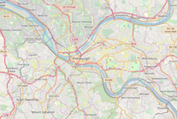
North Side refers to the region of Pittsburgh, Pennsylvania, located to the north of the Allegheny River and the Ohio River. The term "North Side" does not refer to a specific neighborhood, but rather to a disparate collection of contiguous neighborhoods.

Greenfield (Pittsburgh) Neighborhood of Pittsburgh in Allegheny County, Pennsylvania, United States

Greenfield is a neighborhood in Pittsburgh, Pennsylvania, United States. It is represented on Pittsburgh City Council by Corey O'Connor.

Downtown Pittsburgh Neighborhood of Pittsburgh in Allegheny County, Pennsylvania, United States

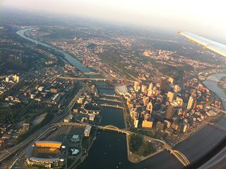
Downtown Pittsburgh, colloquially referred to as the Golden Triangle, and officially the Central Business District, is the urban downtown center of Pittsburgh. It is located at the confluence of the Allegheny River and the Monongahela River whose joining forms the Ohio River. The "triangle" is bounded by the two rivers. The area features offices for major corporations such as PNC Bank, U.S. Steel, PPG, Bank of New York Mellon, Heinz, Federated Investors and Alcoa. It is where the fortunes of such industrial barons as Andrew Carnegie, Henry Clay Frick, Henry J. Heinz, Andrew Mellon and George Westinghouse were made. It contains the site where the French fort, Fort Duquesne, once stood.

Allegheny, Pennsylvania Former city in Pennsylvania, United States

Allegheny City was a municipality that existed in the U.S. state of Pennsylvania from 1788 until it was annexed by Pittsburgh in 1907. It was located north across the Allegheny River from downtown Pittsburgh, with its southwest border formed by the Ohio River, and is known today as the North Side. The city's waterfront district, along the Allegheny and Ohio rivers, became Pittsburgh's North Shore neighborhood.

Highland Park (Pittsburgh neighborhood) Neighborhood of Pittsburgh in Allegheny County, Pennsylvania, United States

Highland Park is a neighborhood in the northeastern part of Pittsburgh, Pennsylvania. Highland Park, the neighborhood, fully encompasses the park with the same name.

Allegheny Center (Pittsburgh) Neighborhood of Pittsburgh in Allegheny County, Pennsylvania, United States

Allegheny Center is a neighborhood on Pittsburgh's North Side. Its zip code is 15212, and it has representation on Pittsburgh City Council by both council members for District 6 and District 1 (Northside).

Allegheny West (Pittsburgh) Neighborhood of Pittsburgh in Pennsylvania, United States

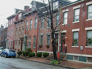
Allegheny West is a historic neighborhood in Pittsburgh, Pennsylvania's North Side. It has two zip codes of both 15233 and 15212, and has representation on Pittsburgh City Council by the council member for District 1.

California-Kirkbride (Pittsburgh) Neighborhood of Pittsburgh in Allegheny County, Pennsylvania, United States

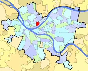
California-Kirkbride is a neighborhood on Pittsburgh, Pennsylvania's North Side.

Banksville (Pittsburgh) Neighborhood of Pittsburgh in Allegheny County, Pennsylvania, United States

Banksville is a neighborhood in Pittsburgh, Pennsylvania. The neighborhood of Banksville is located in the West End of the city and borders the South Hills region. Real estate agencies frequently refer to the Banksville area as Greentree City due to Banksville's shared border with the borough of Green Tree. It has two zip codes of both 15220 and 15216, and has representation in Pittsburgh City Council by the council member for District 2. Theresa Kail-Smith is the current Councilperson for district two. Banksville's primary corridor, Banksville Road, is frequently used as a gateway between the South Hills of Pittsburgh and downtown Pittsburgh via the Fort Pitt Tunnels. Banksville, formerly Union Township, joined the City of Pittsburgh around 1928.

Central Lawrenceville (Pittsburgh) Neighborhood of Pittsburgh in Allegheny County, Pennsylvania, United States

Central Lawrenceville is a neighborhood in the northeast of Pittsburgh, Pennsylvania in the United States. It has a zip code of 15201, and has representation on Pittsburgh City Council by the council member for District 7. It is home to Allegheny Cemetery. Central Lawrenceville is the home of the Pittsburgh Bureau of Fire's 6 Engine and 6 Truck.

Central Northside (Pittsburgh) Neighborhood of Pittsburgh in Allegheny County, Pennsylvania, United States

Central Northside is a neighborhood in the North Side of the city of Pittsburgh, Pennsylvania, USA. It has a zip code of 15212, and has representation on Pittsburgh City Council by the council member for District 6. Originally known as "The Buena Vista Tract", it is densely filled with restored row houses, community gardens and tree lined streets and alleyways.

Fineview (Pittsburgh) Neighborhood of Pittsburgh in Allegheny County, Pennsylvania, United States

Fineview is a neighborhood on Pittsburgh, Pennsylvania's North Side. It has zip codes of both 15212 and 15214, and has representation on Pittsburgh City Council by the council member for District 6 and District 1. Fineview was known to older generations as Nunnery Hill. Its modern name derives from the expansive views of downtown Pittsburgh. The most famous of these views is from the Fineview Overlook at the corner of Catoma and Meadville streets.

Manchester (Pittsburgh) Neighborhood in Pittsburgh, Pennsylvania, United States

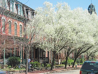
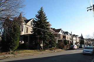
Manchester is a neighborhood on Pittsburgh, Pennsylvania's North Side. It has a ZIP code of 15233, and has representation on Pittsburgh City Council by the council member for District 6. Manchester houses PBF Battalion 1 & 37 Engine, and is covered by PBP Zone 1 and the Bureau of EMS Medic 4. The neighborhood includes the Manchester Historic District, which protects, to some degree, 609 buildings over a 51.6-acre (20.9 ha) area. The district was listed on the National Register of Historic Places in 1975.

Marshall-Shadeland, Pittsburgh Neighborhood of Pittsburgh in Allegheny County, Pennsylvania, United States

Marshall-Shadeland is a neighborhood on Pittsburgh, Pennsylvania's North Side. It has a zip codes of both 15212 and 15214, and has representation on Pittsburgh City Council by the council member for District 1.

Morningside (Pittsburgh) Neighborhood of Pittsburgh in Allegheny County, Pennsylvania, United States

Morningside is a neighborhood on Pittsburgh, Pennsylvania's East End. It has two zip codes, 15201 and 15206, and has a representation on Pittsburgh City Council by Deb Gross for District 7.

North Shore (Pittsburgh) Neighborhood of Pittsburgh in Allegheny County, Pennsylvania, United States

The North Shore is a neighborhood in Pittsburgh, Pennsylvania's North Side. It has a zip code of 15212, and has representation on Pittsburgh City Council by both the council members for District 1 and 6. The neighborhood is home to Heinz Field, PNC Park, and The Andy Warhol Museum.

Troy Hill (Pittsburgh) Neighborhood of Pittsburgh in Allegheny County, Pennsylvania, United States

Troy Hill is a neighborhood in Pittsburgh, Pittsburgh, Pennsylvania's North Side. It has a zip code of 15212, and has representation on Pittsburgh City Council by the council member for District 1.

West End (Pittsburgh) Neighborhood of Pittsburgh in Allegheny County, Pennsylvania, United States

West End Village is a neighborhood in Pittsburgh, Pennsylvania's west city area. It has a zip code of 15220, and has representation on Pittsburgh City Council by the council member for District 2.

Perry North (Pittsburgh) Neighborhood of Pittsburgh in Allegheny County, Pennsylvania, United States

Perry North is a neighborhood in Pittsburgh, Pennsylvania, USA's north city area. It lies within zip codes 15212 and 15214, and has representation on Pittsburgh City Council by the council member for District 1. The highest elevation in Pittsburgh is 1,370 feet at the Brashear Reservoir at the top of Observatory Hill. The Pittsburgh Bureau of fire houses 34 Engine in Perry North.

Perry South (Pittsburgh) Neighborhood of Pittsburgh in Allegheny County, Pennsylvania, United States

Perry South is a neighborhood on Pittsburgh, Pennsylvania's North Side.

References

  1. 1 2 "PGHSNAP 2010 Raw Census Data by Neighborhood". Pittsburgh Department of City Planning PGHSNAP Utility. 2012. Retrieved June 24, 2013.External link in |publisher= (help)
  2. "NPS Focus". National Register of Historic Places. National Park Service . Retrieved August 5, 2011.
  3. "Local Historic Designations". Pittsburgh, PA: Pittsburgh History & Landmarks Foundation. Retrieved August 5, 2011.
  4. 1 2 3 "Dutchtown Historic District". Living Places. Gombach Group. Retrieved November 3, 2011.
  5. "The Next Page: Reviving the North Side's "Lost City"". Pittsburgh Post-Gazette. April 8, 2007. Retrieved November 3, 2011.
  6. "East Allegheny". Council District 1 Maps. City of Pittsburgh. Archived from the original on November 18, 2011. Retrieved November 3, 2011.
  7. "Design Guidelines: Deutschtown Historic District" (PDF). City of Pittsburgh. Archived from the original (PDF) on November 25, 2011. Retrieved November 3, 2011.
  8. Miller, Eric. "If we change it, they will come". New Colonist. Archived from the original on November 18, 2011. Retrieved November 3, 2011.
  9. Kirkland, Kevin (July 17, 2010). "Buying Here: Deutschtown". Pittsburgh Post-Gazette. Retrieved November 3, 2011.
  10. "Deutschtown".
  11. "Pittsburgh's Deutschtown House Tour highlights three decades of neighborhood revitalization". Archived from the original on November 9, 2011. Retrieved November 3, 2011.
  12. "Our Neighborhood: Deutschtown". The Priory Hotel.
  13. Regan, Bob (2015). Pittsburgh Steps, The Story of the City's Public Stairways. Globe Pequot. ISBN   978-1-4930-1384-5.
  14. ""Criminal Minds" the Tall Man (TV Episode 2018) - IMDb". IMDb .

Further reading