Allegheny Center (Pittsburgh)

Last updated
Allegheny Center
Carnegie Free Library of Allegheny.jpg
Pgh locator allegheny center.svg
Coordinates: 40°27′11″N80°00′18″W / 40.453°N 80.005°W / 40.453; -80.005
Country United States
State Pennsylvania
County Allegheny County
City Pittsburgh
Area
[1]
  Total0.21 sq mi (0.5 km2)
Population
  Total933
  Density4,400/sq mi (1,700/km2)

Allegheny Center is a neighborhood on Pittsburgh's North Side. Its zip code is 15212, and it has representation on Pittsburgh City Council by both council members for District 6 (Downtown, North Shore) and District 1 (Northside).

Contents

History

In 1783, the Commonwealth of Pennsylvania established a 3000-acre tract of land north of where the Allegheny River merged with the Ohio River. [3] John Redick created an initial town plan for Allegheny City- which featured 36 city blocks surrounded by a common grazing area - the following year. [4] That initial 36-block area is today's Allegheny Center. It is still surrounded on three sides by the former grazing area, now a public park called Allegheny Commons. On either side of this park are the neighborhoods of Allegheny West and East Allegheny.

Because Allegheny City was intended by the Pennsylvania Legislature to serve as the county seat of Allegheny County, the central blocks of Redick's 36-block plan were designed for public uses, including a market house and post office. The main thoroughfare was East Ohio Street, which stretched from Allegheny West through Allegheny Center and then to Allegheny East and beyond.

From the 19th century to 1907, Allegheny Center was thus the hub of downtown Allegheny City. The Children's Museum of Pittsburgh (consisting of the old Allegheny Post Office and Buhl Planetarium joined by a 2006 addition) is located within it, as is the old Carnegie Free Library of Allegheny (now the New Hazlett Theater and the Children's MuseumLab). Allegheny Center is also home to the National Aviary, situated within West Park.

After 1907 (when Pittsburgh annexed Allegheny City), this area continued to be a hub for those residents of what was now Pittsburgh's North Side. But the area deteriorated as: 1) Allegheny's wealthiest residents, who had founded Allegheny Country Club in 1895, moved the club to Sewickley in 1902 and began moving their residences along with it; 2) the Great Depression caused an economic slowdown; and 3) rationing during World War II prevented much investment in the buildings. As one example of the trend, the landmark Boggs & Buhl department store, which had done a thriving business among Allegheny City's wealthy residents, steadily lost money after 1931 and was closed in 1958. [5]

In the 1950s, community leaders discussed how to revitalize the historic hub of Allegheny City and established a modern plan for Allegheny Center. Designed by architects Deeter & Ritchey, it involved a $65 million project by Alcoa Properties, Inc. The construction project razed about 518 buildings (including the Boggs & Buhl department store) - many of them taken by eminent domain - to make way for 2 professional buildings, 4 apartment complexes totaling 840 units, 50 townhouses, a shopping mall, and a 3-acre (12,000 m2) public square. The public square was the object of an international design competition sponsored by the Pittsburgh Urban Redevelopment Authority. The entire Allegheny Redevelopment Area encompasses approximately 79 acres (320,000 m2) on the North Side, about a half-mile from downtown Pittsburgh.

The project converted what had been an open, walkable business district into an enclosed mall called Allegheny Center Mall that had few pedestrian entrances and sat above an underground parking garage. The central portion of East Ohio Street was closed, and drivers were forced to take a new ring road around the mall and the other blocks of Redick's initial plan to proceed east or west.

The former Allegheny Center Mall from PNC Park in 2014. Allegheny Center Mall.jpg
The former Allegheny Center Mall from PNC Park in 2014.

The mall, opened in 1965 and anchored by Sears, F. W. Woolworth Company, and Zayre, had some initial success, but it did not revive the business fortunes of Allegheny City, which continued to decline after Interstate 279 allowed area residents to drive to the northern suburbs to shop. [6] [7]

The mall's stores began closing in the 1990s, and the mall gradually became a successful office complex. [8]

Today,[ when? ] the 36-block area initially planned by John Redick consists of the Allegheny Center Mall - now Nova Place, which contains 1.5 million square feet of Class A office space in the old mall concourse, plus two of the office towers, restaurants, including Federal Galley, a fitness center, and Alloy 26, Pittsburgh's largest coworking space, which is located in the concourse [9] - and several public structures including the Children's Museum of Pittsburgh. A former business district along North Avenue in Central Northside, which deteriorated along with Allegheny Center, is also being revived.

Historical population
CensusPop.
1940 4,521
1950 3,862−14.6%
1960 2,512−35.0%
1970 632−74.8%
1980 1,586150.9%
1990 1,262−20.4%
2000 886−29.8%
2010 9335.3%
[10] [11]

Surrounding Pittsburgh neighborhoods

See also

Related Research Articles

North Side (Pittsburgh) Region of Pittsburgh, Pennsylvania

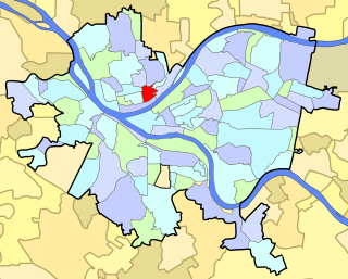
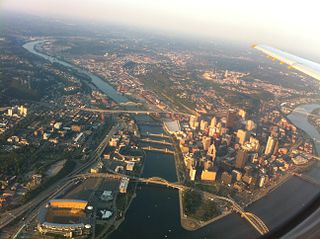
North Side refers to the region of Pittsburgh, Pennsylvania, located to the north of the Allegheny River and the Ohio River. The term "North Side" does not refer to a specific neighborhood, but rather to a disparate collection of contiguous neighborhoods.

Downtown Pittsburgh Neighborhood of Pittsburgh in Allegheny County, Pennsylvania, United States

Downtown Pittsburgh, colloquially referred to as the Golden Triangle, and officially the Central Business District, is the urban downtown center of Pittsburgh. It is located at the confluence of the Allegheny River and the Monongahela River whose joining forms the Ohio River. The "triangle" is bounded by the two rivers. The area features offices for major corporations such as PNC Bank, U.S. Steel, PPG, Bank of New York Mellon, Heinz, Federated Investors and Alcoa. It is where the fortunes of such industrial barons as Andrew Carnegie, Henry Clay Frick, Henry J. Heinz, Andrew Mellon and George Westinghouse were made. It contains the site where the French fort, Fort Duquesne, once stood.

Allegheny, Pennsylvania Former city in Pennsylvania, United States

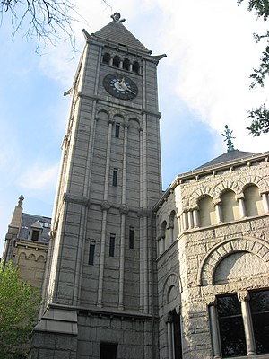
Allegheny City was a municipality that existed in the U.S. state of Pennsylvania from 1788 until it was annexed by Pittsburgh in 1907. It was located north across the Allegheny River from downtown Pittsburgh, with its southwest border formed by the Ohio River, and is known today as the North Side. The city's waterfront district, along the Allegheny and Ohio rivers, became Pittsburgh's North Shore neighborhood.

The Gateway (Salt Lake City) Shopping mall in Salt Lake City, Utah, U.S.

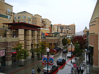
The Gateway is a large, open-air retail, residential, and office complex in Salt Lake City, Utah, United States. It is centered on the historic Union Pacific Depot on the west side of Downtown Salt Lake City between 50 North and 200 South streets and between 400 and 500 West streets. Rio Grande Street has been the site of many special events and becomes a one-way street and heads north through the center. The center has featured as many as 89 outlets, but recent changes have allowed the center to provide new retail shopping experiences and become more of a social gathering place centered on dining and nightlife.

Carnegie Science Center Science museum, , Technology museum in Pittsburgh, Pennsylvania

The Carnegie Science Center is one of the four Carnegie Museums of Pittsburgh, Pennsylvania. It is located in the Chateau neighborhood. It is located across the street from Heinz Field.

Allegheny West, Philadelphia Neighborhood of Philadelphia in Philadelphia County, Pennsylvania, United States

Allegheny West is a neighborhood in the North Philadelphia section of Philadelphia. It is named after an association formed by Pep Boys and Tasty Baking Company, among others, and the community bordering East Falls, Strawberry Mansion and Tioga-Nicetown. Its location in the vicinity of Allegheny Avenue on the western side of Broad Street.

Allegheny West (Pittsburgh) Neighborhood of Pittsburgh in Pennsylvania, United States

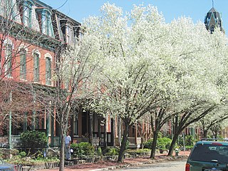
Allegheny West is a historic neighborhood in Pittsburgh, Pennsylvania's North Side. It has two zip codes of both 15233 and 15212, and has representation on Pittsburgh City Council by the council member for District 1.

Central Northside (Pittsburgh) Neighborhood of Pittsburgh in Allegheny County, Pennsylvania, United States

Central Northside is a neighborhood in the North Side of the city of Pittsburgh, Pennsylvania, USA. It has a zip code of 15212, and has representation on Pittsburgh City Council by the council member for District 6. Originally known as "The Buena Vista Tract", it is densely filled with restored row houses, community gardens and tree lined streets and alleyways.

East Allegheny (Pittsburgh) Neighborhood of Pittsburgh in Allegheny County, Pennsylvania, United States

East Allegheny, also known as Deutschtown, is a neighborhood on Pittsburgh's North Side. It has a ZIP Code of 15212, and has representation on Pittsburgh City Council by the council member for District 1. The Pittsburgh Bureau of Fire houses 32 Engine and 32 Truck in Deutschtown.

Fineview (Pittsburgh) Neighborhood of Pittsburgh in Allegheny County, Pennsylvania, United States

Fineview — known to older generations as Nunnery Hill — is a neighborhood on Pittsburgh's North Side with expansive views of downtown Pittsburgh. The most famous of these views is from the Fineview Overlook at the corner of Catoma Street and Meadville Street.

Manchester (Pittsburgh) Neighborhood in Pittsburgh, Pennsylvania, United States

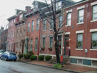
Manchester is a neighborhood on Pittsburgh, Pennsylvania's North Side. It has a ZIP code of 15233, and has representation on Pittsburgh City Council by the council member for District 6. Manchester houses PBF Battalion 1 & 37 Engine, and is covered by PBP Zone 1 and the Bureau of EMS Medic 4. The neighborhood includes the Manchester Historic District, which protects, to some degree, 609 buildings over a 51.6-acre (20.9 ha) area. The district was listed on the National Register of Historic Places in 1975.

North Shore (Pittsburgh) Neighborhood of Pittsburgh in Allegheny County, Pennsylvania, United States

The North Shore is a neighborhood in Pittsburgh, Pennsylvania's North Side. It has a zip code of 15212, and has representation on Pittsburgh City Council by both the council members for District 1 and 6. The neighborhood is home to Heinz Field, PNC Park, and The Andy Warhol Museum.

National Aviary

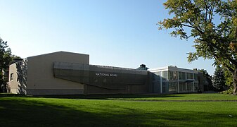
The National Aviary, located in Pittsburgh, Pennsylvania, is the only independent indoor nonprofit aviary in the United States. It is also the country's largest aviary, and the only one accorded honorary "National" status by the United States Congress.

Allegheny Commons (Pittsburgh) Municipal park located in the North Side region of Pittsburgh

Allegheny Commons is a municipal park located in Pittsburgh's North Side. The park surrounds the neighborhood of Allegheny Center. Dating to 1867, it is the oldest park in the city of Pittsburgh.

Oakland City Center is an office, shopping and hotel complex in Downtown Oakland, Oakland, California. The complex is the product of a redevelopment project begun in the late 1950s. It covers twelve city blocks between Broadway on the east, Martin Luther King Jr. Way on the west, Frank H. Ogawa Plaza on 14th Street on the north side of the complex and the Oakland Convention Center and Marriott Hotel extend south to 10th Street. An hourly parking garage is located beneath the complex's shopping mall. The mall features an upscale fitness and racquet club, in addition to numerous take-out restaurants and other stores. The complex is served by the 12th Street/Oakland City Center BART station.

Allegheny General Hospital Hospital in Pennsylvania, United States

Allegheny General Hospital is a large urban hospital located at 320 East North Avenue in Pittsburgh, Pennsylvania, United States. It is part of the larger Allegheny Health Network.

Childrens Museum of Pittsburgh

The Children's Museum of Pittsburgh is a hands-on interactive children's museum in Pittsburgh, Pennsylvania. It is in the Allegheny Center neighborhood in Pittsburgh's Northside.

Allegheny Post Office United States historic place

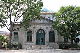
Allegheny Post Office, also known as Old North Post Office, The Landmarks Museum, is a building built in 1897 in the Allegheny City area that is now within Pittsburgh, Pennsylvania. It is located in Pittsburgh's North Side.

Buhl Planetarium and Institute of Popular Science Building

The Buhl Planetarium and Institute of Popular Science Building, also known as the "People's Observatory", is located at 10 Children's Way in the Allegheny Center neighborhood of Pittsburgh, Pennsylvania.

References

  1. "Census: Pittsburgh" (PDF). Pittsburgh Department of City Planning. January 2006. Archived from the original (PDF) on August 10, 2007. Retrieved 2007-07-19.
  2. "Census: Pittsburgh". Pittsburgh Department of City Planning. April 2013. Retrieved 2013-04-26.
  3. "Dutchtown Historic District". Living Places. Gombach Group. Retrieved 3 November 2011.
  4. "The Next Page: Reviving the North Side's "Lost City"". Pittsburgh Post-Gazette. April 8, 2007. Retrieved 3 November 2011.
  5. "Boggs & Buhl Department Store, once a North Side institution". Pittsburgh Senior News. December 2004. Retrieved 3 November 2011.
  6. Canning, John (5 October 2010). "Allegheny Center: a long history of redevelopment". Northside Chronicle. Archived from the original on 15 March 2012. Retrieved 3 November 2011.
  7. "Allegheny Center Mall: Pittsburgh, PA".
  8. Spatter, Sam (December 28, 2010). "Former Allegheny Center Mall successful with offices". Pittsburgh Tribune-Review.
  9. "About Nova Place | Nova Place". novaplace.com. Retrieved 2019-09-25.
  10. "PGHSNAP - Neighborhoods: All Raw Data".
  11. "Census:Pittsburgh" (PDF). Archived from the original (PDF) on August 10, 2007. Retrieved 2 September 2012.