South Side Slopes, Pittsburgh

Last updated
South Side Slopes
Southside Slopes from Carson.jpg
South Side Slopes from E. Carson Street in South Side Flats.
Pgh locator southside slopes.svg
Coordinates: 40°25′N79°58′W / 40.42°N 79.97°W / 40.42; -79.97
Country United States
State Pennsylvania
County Allegheny County
City Pittsburgh
Area
[1]
  Total0.716 sq mi (1.85 km2)
Population
 (2010) [1]
  Total4,423
  Density6,200/sq mi (2,400/km2)

South Side Slopes is a neighborhood in Pittsburgh, Pennsylvania's South Side area. The neighborhood comprises the hills from the South Side Flats neighborhood along the Monongahela River from the Liberty Bridge (west) to beyond Josephine Street (east).

Contents

In many parts of the South Side Slopes, homes offer panoramic views of the city skyline that span the distance from beyond McKees Rocks, Pennsylvania, to Homestead, Pennsylvania. Many homes are perched well above the city skyline. This neighborhood provides access to the South Side Flats by various means, including the many public staircases.

Every autumn the South Side Slopes Neighborhood Association (SSSNA) hosts its annual "StepTrek", where participants travel over the various public step streets. Pittsburgh, like many cities in the United States built on hillsides, classifies public staircases as streets. The hills being steep, staircases allowed access to the different parts of the slopes neighborhood. The SSSNA hopes to maintain the staircases as a legacy of its history as a mining town.[ citation needed ]

The Mission Street steps between Oakley Street and Barry Street in addition to the top of Yard Way off Pius St. offer views of the South Side Flats neighborhood and downtown Pittsburgh. These public staircases are sometimes called paper streets, being pedestrian streets shown on City maps but not accessible by vehicles.

The neighborhood has representation on the Pittsburgh City Council by the council member for District 3 (Central South Neighborhoods). The Pittsburgh Bureau of Fire houses 24 Engine and 24 Truck on the South Side. It is located on Mary Street just off of Carson Street. The South Side Slopes area is also served by Engine Co 22 which is located in the neighborhood on Arlington Avenue adjoining South Side Park.

South Side Park is a City Park with hiking trails, a small orchard patch and views of the City of Pittsburgh skyline. It is home to many species of birds, small animals and deer. It contains a small wetlands area, complete with cattails and many species of wildlife. Black locust trees form a mature canopy over the park. It also includes a community garden at the former Bandi Schaum baseball field on the lower plateau off Mission Street across from the Mission Street water pumping station.

A cor-ten sculpture representing the neighborhood's topography and buildings is on display in the garden of Paul of the Cross Monastery. [2]

One of the many steep streets in the South Side Slopes, with a staircase for a sidewalk. Southside Slopes Sterling St.jpg
One of the many steep streets in the South Side Slopes, with a staircase for a sidewalk.

History

In 1763, King George III of Great Britain granted John Ormsby, a soldier in the French and Indian War as well as the alleged first settler of Pittsburgh, 2,400 acres of land along the southern banks of the Monongahela River for his service in the capture of Fort Duquesne. Ormsby divided the land into four boroughs – South Pittsburgh, Birmingham, Ormsby, and East Birmingham, which is present day South Side Slopes. [3]

South Side expanded and grew in order to keep up with Pittsburgh's industrial boom, adopting the nickname "Workshop of the World". The industry of glass-making was predominant in the early 1800s, and later the banks of the Monongahela River became home to the iron and steel operations run by the company J&L Steel. [3]

J&L (The Jones and Laughlin Steel Company) eventually became South Side's largest employer as by 1910 it employed 15,000 workers. [4] The majority of these workers came as immigrants from European nations such as Germany, Ireland, Poland, Lithuania, the Ukraine, and the Slavic nations and settled into homes in the present day South Side Slopes. The houses built for them were traditionally one room wide, two rooms deep, and up to four stories high. The houses are built into the hillside with narrow walkways between them. Most of the structures and houses in both South Side Slopes are balloon-framed whereas many of those on the South Side Flats were built from brick, in a rectangular fashion. Many of them were ornamented in the popular style of the 1900s – Romanesque, Italianate and Second Empire. They are fashioned in a classical Victorian style row home way with carved doorways, cornices, corbelling, cast iron ornaments and geometric slate patterns. [5] The Slopes is rich in culture as many immigrants wanted to preserve their native cultures and languages; so they built many bars and churches, many of which still exist today. [4]

Geography

South Side Slopes is located at 40.42 N and 79.97 W. [6] The area South Side Slopes covers is approximately 0.716 square miles (1.85 km2) or 460.632 acres. [7] It is made up of many slopes with elevations ranging from 791 feet (241 m) to 1,174 feet (358 m). There are some areas that are too steep for automobile navigation so the numerous staircases located throughout South Side Slopes serve as the "streets". There have been approximately 70 sets of staircases found in the neighborhood. [8]

South Side Slopes is part of District 3 in Allegheny County. [9] 18th Street, Arlington Avenue, and Josephine Street are two of the main roads that run through the neighborhood. [10] It is approximately 2.8 miles (4.5 km) from the Monongahela River [11] and the historic Birmingham Bridge. The Slopes neighborhood is also close to the diverse East Carson Street and the SouthSide Works shopping center.

South Side Slopes has an overall cold climate, [12] meaning it has about 5,400 heating degree days and fewer than 9,000 heating degree days based on a temperature of 65 degrees Fahrenheit. [13] It can experience temperatures that range from 90 degrees Fahrenheit to negative 10 degrees Fahrenheit. The area also accumulates an average of 30 to 40 inches of precipitation per year. [14] Allegheny County can also get anywhere from zero to twenty inches of snow per month during the months of December, January, February, and March. [15]

Surrounding neighborhoods

South Side Slopes has seven borders, six with Pittsburgh neighborhoods including the South Side Flats to the north, Arlington Heights to the southeast, Arlington to the south, Allentown to the west and northwest, and South Shore and Mt. Washington to the northwest. The other border is with the borough of Mt. Oliver to the southwest. [16]

Demographics

According to the 2010 census, [1] there were 5,007 people living in the neighborhood and 2,580 total housing units within its boundaries. The racial makeup of the neighborhood was 88.54% White, 7.14% African American, 0.95% Asian, 1.06% from other races, and 2.31% from two or more races. Hispanics and Latinos of any race were 2.1% of the population.

Out of the total number of housing units, 83.5% were occupied. The owner occupancy percentage is 61.2%. There were 12.23% of households with those under the age of 18 and 18.34% with those over the age of 60.

The population was generally decreasing with 15,083 in 1940; 12,998 in 1950; 10,842 in 1960; 9,739 in 1970; 7,020 in 1980; 5,007 in 2000. [1]

See also

Related Research Articles

Downtown Pittsburgh Neighborhood of Pittsburgh in Allegheny County, Pennsylvania, United States

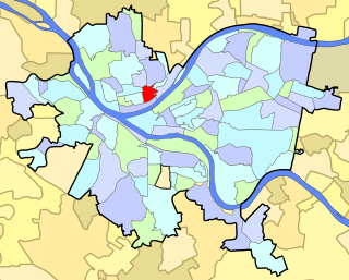
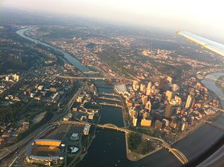
Downtown Pittsburgh, colloquially referred to as the Golden Triangle, and officially the Central Business District, is the urban downtown center of Pittsburgh. It is located at the confluence of the Allegheny River and the Monongahela River whose joining forms the Ohio River. The "triangle" is bounded by the two rivers. The area features offices for major corporations such as PNC Bank, U.S. Steel, PPG, Bank of New York Mellon, Heinz, Federated Investors and Alcoa. It is where the fortunes of such industrial barons as Andrew Carnegie, Henry Clay Frick, Henry J. Heinz, Andrew Mellon and George Westinghouse were made. It contains the site where the French fort, Fort Duquesne, once stood.

Uptown Pittsburgh Neighborhood of Pittsburgh in Allegheny County, Pennsylvania, United States

Uptown or The Bluff is a neighborhood in the city of Pittsburgh, Pennsylvania to the southeast of the city's Central Business District. It is bordered in the north by the Hill District and located across the Monongahela River from South Side. The predominant area zip code is 15219.

South Side (Pittsburgh) Neighborhoods of Pittsburgh in Allegheny, Pennsylvania, United States

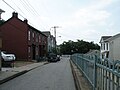
South Side is an area in Pittsburgh, Pennsylvania, United States, located along the Monongahela River across from Downtown Pittsburgh. The South Side is officially divided into two neighborhoods, South Side Flats and South Side Slopes. Both the Flats and the Slopes are represented on Pittsburgh City Council by Bruce Kraus. The business district stretches along East Carson Street, which is home to many small shops, restaurants and bars. In 2006, more than 80 bars and pubs operated in the South Side Flats. The neighborhood has an urban fabric with rowhouses.

Allentown, Allegheny County, Pennsylvania Neighborhood in Allegheny County, Pennsylvania, United States

Allentown is a neighborhood located in southern portion of the city of Pittsburgh, Allegheny County, Pennsylvania. The ZIP code used by residents is 15210, and has representation on the Pittsburgh City Council by the council member for District 3.

Arlington Heights (Pittsburgh) Neighborhood of Pittsburgh in Allegheny County, Pennsylvania, United States

Arlington Heights is a neighborhood in the southern portion of Pittsburgh, Pennsylvania. The zip code used by residents is 15210, and this neighborhood is represented on the Pittsburgh City Council by the council member for District 3. This neighborhood is home to five government housing projects.

South Side Flats (Pittsburgh) Neighborhood in Pittsburgh, Pennsylvania, United States

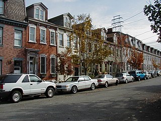
The South Side Flats is a neighborhood in Pittsburgh, Pennsylvania's South Side area. It is located just south of the Monongahela River. The neighborhood has one of the City of Pittsburgh's largest concentrations of 19th-century homes, which has prompted outsiders to call the neighborhood the City's Georgetown. It includes many bars and restaurants as well as residences. The main throughway in the South Side Flats is East Carson Street. The street is home to a significant portion of Pittsburgh's nightlife.

Carrick (Pittsburgh) Place in Pennsylvania, United States

Carrick is a south neighborhood of Pittsburgh, Pennsylvania in the United States. It is served by two zip codes, 15210 and 15227, and has representation on Pittsburgh City Council by the council member for District 4 with a part in District 3.

California-Kirkbride (Pittsburgh) Neighborhood of Pittsburgh in Allegheny County, Pennsylvania, United States

California-Kirkbride is a neighborhood on Pittsburgh, Pennsylvania's North Side.

Central Northside (Pittsburgh) Neighborhood of Pittsburgh in Allegheny County, Pennsylvania, United States

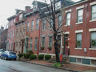
Central Northside is a neighborhood in the North Side of the city of Pittsburgh, Pennsylvania, USA. It has a zip code of 15212, and has representation on Pittsburgh City Council by the council member for District 6. Originally known as "The Buena Vista Tract", it is densely filled with restored row houses, community gardens and tree lined streets and alleyways.

East Allegheny (Pittsburgh) Neighborhood of Pittsburgh in Allegheny County, Pennsylvania, United States

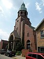
East Allegheny, also known as Deutschtown, is a neighborhood on Pittsburgh's North Side. It has a ZIP Code of 15212, and has representation on Pittsburgh City Council by the council member for District 1. The Pittsburgh Bureau of Fire houses 32 Engine and 32 Truck in Deutschtown.

Glen Hazel (Pittsburgh) Neighborhood of Pittsburgh in Allegheny County, Pennsylvania, United States

Glen Hazel is a neighborhood in Pittsburgh, Pennsylvania's east city area. It has both zip codes of 15207 and 15217, and has representation on Pittsburgh City Council by Corey O'Connor. The neighborhood is located on a hilltop along the Monongahela River and primarily consists of a public housing development of the same name, along with a county-owned nursing home.

Hays (Pittsburgh) Neighborhood of Pittsburgh in Allegheny County, Pennsylvania, United States

Hays is a neighborhood in the 31st Ward of the east side of Pittsburgh, Pennsylvania. It is represented on the Pittsburgh City Council by the representative of District 5. It occupies ZIP codes 15227, 15207, and 15236. It is named after James H. Hays, who opened a coal-mining operation called Hays and Haberman Mines in 1828.

North Shore (Pittsburgh) Neighborhood of Pittsburgh in Allegheny County, Pennsylvania, United States

The North Shore is a neighborhood in Pittsburgh, Pennsylvania's North Side. It has a zip code of 15212, and has representation on Pittsburgh City Council by both the council members for District 1 and 6. The neighborhood is home to Heinz Field, PNC Park, and The Andy Warhol Museum.

Spring Garden (Pittsburgh) Neighborhood of Pittsburgh in Allegheny County, Pennsylvania, United States

Spring Garden is a small neighborhood on Pittsburgh, Pennsylvania's North Side. It takes its name from Spring Garden Avenue, which follows the floor of the valley that separates the two adjacent hilltop neighborhoods of Spring Hill and Troy Hill. Like those neighborhoods, Spring Garden was initially settled by the descendants of Germans and Austrians who had emigrated from Europe to East Allegheny in Allegheny City. These initial residents of Spring Garden worked in slaughterhouses, rendering factories, and tanneries located in this valley neighborhood.

Troy Hill (Pittsburgh) Neighborhood of Pittsburgh in Allegheny County, Pennsylvania, United States

Troy Hill is a neighborhood on Pittsburgh, Pennsylvania's North Side. It has a zip code of 15212, and has representation on Pittsburgh City Council by the council member for District 1.

West End (Pittsburgh) Neighborhood of Pittsburgh in Allegheny County, Pennsylvania, United States

West End Village is a neighborhood in Pittsburgh, Pennsylvania's west city area. It has a zip code of 15220, and has representation on Pittsburgh City Council by the council member for District 2.

South Shore (Pittsburgh) Neighborhood of Pittsburgh in Allegheny County, Pennsylvania, United States

The South Shore is a neighborhood in Pittsburgh, Pennsylvania South Side. The South Shore consists of the area surrounding Carson Street, from the West End Bridge to the Liberty Bridge.

John Ormsby (1720–1805) was a soldier in the French and Indian War, Pontiac's Rebellion, and the American Revolution, and among the first settlers of Pittsburgh, Pennsylvania. The son of the Anglo-Irish landed gentry, he emigrated from Ireland to the Thirteen Colonies in 1752. After Pontiac's Rebellion, he received a land grant from King George III, and established a homestead on the banks of the Monongahela River. He established extensive economic and merchant interests in Bedford, Pennsylvania, and at the head of the Ohio River.

Mount Washington, Pittsburgh Place in Pennsylvania, United States

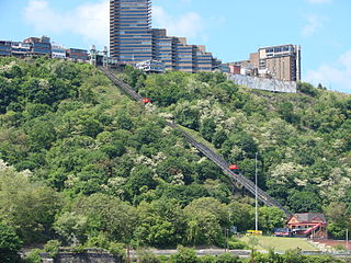
Mount Washington is a neighborhood in Pittsburgh, Pennsylvania's south city area. It has a zip code of 15211 and has representation on Pittsburgh City Council by both the council members for District 3 and District 2.

References

  1. 1 2 3 4 "PGHSNAP 2010 Raw Census Data by Neighborhood". Pittsburgh Department of City Planning PGHSNAP Utility. 2012. Retrieved 28 June 2013.{{cite news}}: External link in |publisher= (help)
  2. Jones, Diana Nelson (2008). "Slopes neighbors to dedicate new sculpture". Pittsburgh Post-Gazette (September 24).
  3. 1 2 Visit the South Side Archived 2010-08-25 at the Wayback Machine . Pittsburgh Neighborhood Tours. Retrieved on 2010-11-29.
  4. 1 2 "Southside Slopes". Archived from the original on October 9, 2009. Retrieved November 21, 2010.
  5. East Carson Street Historic District, Pittsburgh City, Allegheny County, Pittsburgh PA 15203. Livingplaces.com. Retrieved on 2010-11-29.
  6. Geography. Retrieved 2010 20 11.
  7. "Census: Pittsburgh" (PDF). Pittsburgh Department of City Planning. January 2006. Archived from the original (PDF) on 2007-08-10. Retrieved 2007-07-19.
  8. Post Gazette article. Retrieved 2016 27 07.
  9. "District 3 Map". Archived from the original on 2011-01-06. Retrieved 2010-11-21., map of District 3 in Pittsburgh
  10. Archived 2006-04-28 at the Library of Congress Web Archives South Side Slopes Map
  11. Archived 2006-04-28 at the Library of Congress Web Archives streets around South Side Slopes. Retrieved 2010 20 11.
  12. U.S. climates. Retrieved 2010-20-11.
  13. Climate descriptions. Retrieved 2010-20-11.
  14. U.S. climate maps. Retrieved 2010-20-11.
  15. Weather maps. Retrieved 2010 21 1.
  16. "Southside Slopes Map". Archived from the original on 2009-10-09. Retrieved 2009-07-27., Map of South Side Slopes. Retrieved 2010-11-17.