Crafton is a borough in Allegheny County, Pennsylvania, United States, west of downtown Pittsburgh. The population grew from 1,927 in 1900 to 4,583 in 1910 and to 7,163 in 1940. The population was 5,951 at the 2010 census.

Greenfield is a neighborhood in Pittsburgh, Pennsylvania, United States. It is represented on Pittsburgh City Council by Corey O'Connor.
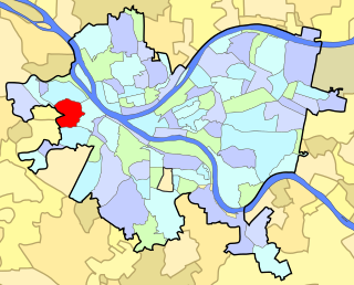
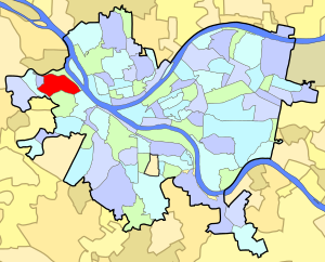
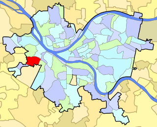
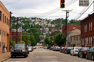
Crafton Heights is a neighborhood in Pittsburgh, Pennsylvania. Its name is derived from the neighboring borough, Crafton Borough, and the majority of today's community was annexed to the City of Pittsburgh in 1921. Crafton Heights is located west of downtown Pittsburgh, and is surrounded by Elliot, Sheraden, and Westwood.

Homewood is a predominantly African-American neighborhood of Pittsburgh, Pennsylvania, United States, officially divided into three neighborhoods: Homewood North, Homewood South and Homewood West.
Elliott is a small, hilly neighborhood in Pittsburgh, Pennsylvania's West End Region. Elliott is represented on the Pittsburgh City Council by the council member for District 2, and uses the ZIP code 15220.
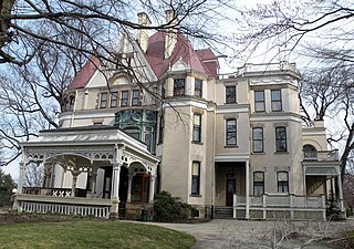
Point Breeze, or South Point Breeze, is a largely residential neighborhood in Pittsburgh, Pennsylvania, USA. The community was named after a tavern once located there.

Carrick is a south neighborhood of Pittsburgh, Pennsylvania in the United States. It is served by two zip codes, 15210 and 15227, and has representation on Pittsburgh City Council by the council member for District 4 with a part in District 3.

Chartiers is a neighborhood in Pittsburgh, Pennsylvania's west area. It has a zip code of 15204, and has representation on Pittsburgh City Council by the council member for District 2. The neighborhood was named after Peter Chartier, a trapper of French and Native American parentage who established a trading post at the mouth of Chartiers Creek in 1743.

Esplen is a neighborhood in Pittsburgh, Pennsylvania's west city area. It has a zip code of 15204, and has representation on Pittsburgh City Council by the council member for District 2.

Fairywood is a neighborhood on Pittsburgh, Pennsylvania's west end. It has a zip code of 15205, and has representation on Pittsburgh City Council by the council member for District 2. It is the westernmost neighborhood in the City of Pittsburgh.
Manchester is a neighborhood on Pittsburgh, Pennsylvania's North Side. It has a ZIP code of 15233, and has representation on Pittsburgh City Council by the council member for District 6. Manchester houses PBF Battalion 1 & 37 Engine, and is covered by PBP Zone 1 and the Bureau of EMS Medic 4. The neighborhood includes the Manchester Historic District, which protects, to some degree, 609 buildings over a 51.6-acre (20.9 ha) area. The district was listed on the National Register of Historic Places in 1975.
Morningside is a neighborhood on Pittsburgh, Pennsylvania's East End. It has two zip codes, 15201 and 15206, and has a representation on Pittsburgh City Council by Deb Gross for District 7.

Windgap is a neighborhood in the west area of Pittsburgh, Pennsylvania, United States. It has a zip code of 15204, and has representation on Pittsburgh City Council by the council member for District 2.

Oakwood is a neighborhood in Pittsburgh, Pennsylvania's southwest city area. It has a zip code of 15205, and has representation on Pittsburgh City Council by the council member for District 2.

Troy Hill is a neighborhood in Pittsburgh, Pittsburgh, Pennsylvania's North Side. It has a zip code of 15212, and has representation on Pittsburgh City Council by the council member for District 1.
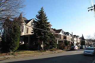
Westwood is a neighborhood in the West End Region of Pittsburgh, Pennsylvania. Beginning as a part of the now-defunct Township of Chartiers and existing for a short time as an independent borough, Westwood was annexed by the City of Pittsburgh in three pieces: the eastern third in 1872, and the remaining sectors progressing west in 1921 and 1927. Westwood is a quiet residential community inhabited by a large variety of residents, and exhibits an eclectic mix of architectural styles that span many periods. Among these is the John Frew House, one of the oldest surviving structures west of the Allegheny Mountains, which dates to 1790. Westwood also contains a public primary school bearing the community's name, as well as a public swimming pool, a playground, and ballfields. The neighborhood's main thoroughfare is Noblestown Road, and Noble Manor is its major commercial district. It has a zip codes of both 15205 and 15220, and has representation on Pittsburgh City Council by the council member for District 2. The Pittsburgh Bureau of Fire houses 29 Engine in Westwood.

West End Village is a neighborhood in Pittsburgh, Pennsylvania's west city area. It has a zip code of 15220, and has representation on Pittsburgh City Council by the council member for District 2.
South Side Slopes is a neighborhood in Pittsburgh, Pennsylvania's South Side area. The neighborhood comprises the hills from the South Side Flats neighborhood along the Monongahela River from the Liberty Bridge (west) to beyond Josephine Street (east).

William Joseph Winter is the auxiliary bishop emeritus of the Roman Catholic diocese of Pittsburgh, Pennsylvania and the titular bishop of Uthina.

Thaddeus Stevens Elementary School located at 824 Crucible Street in the Elliott neighborhood of Pittsburgh, Pennsylvania, was built in 1939. It was a part of Pittsburgh Public Schools and served Elliott, Esplen, Sheraden, West End, and Westgate Village.