The Hill District is a grouping of historically African American neighborhoods in the City of Pittsburgh, Pennsylvania. Beginning in the years leading up to World War I, "the Hill" was the cultural center of black life in the city and a major center of jazz. Despite its cultural and economic vibrancy, in the mid-1950s a substantial area was slated for redevelopment, displacing about 8,000 individuals.
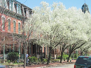
Friendship is a neighborhood of large Victorian houses in the East End of the City of Pittsburgh, Pennsylvania, United States, about four miles (6 km) east of Pittsburgh's Golden Triangle. Friendship is bordered on the north by Garfield, on the east by East Liberty, and on the south by Shadyside, and on the west by Bloomfield. It is divided into 3 Pittsburgh City Council districts.

Homewood is a predominantly African-American neighborhood of Pittsburgh, Pennsylvania, United States, officially divided into three neighborhoods: Homewood North, Homewood South and Homewood West.

Larimer is a neighborhood in the East End of the City of Pittsburgh, Pennsylvania in the United States. The neighborhood takes its name from William Larimer, who grew up in nearby Westmoreland County and, after making a fortune in the railroad industry, built a manor house overlooking East Liberty along a path that came to be called "Larimer Lane" and later Larimer Avenue.

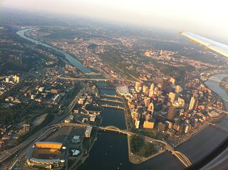
Uptown or The Bluff is a neighborhood in the city of Pittsburgh, Pennsylvania to the southeast of the city's Central Business District. It is bordered in the north by the Hill District and located across the Monongahela River from South Side. The predominant area zip code is 15219.

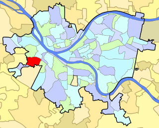
East Carnegie is a neighborhood located southwest of downtown Pittsburgh, Pennsylvania adjacent to the neighborhood of Oakwood. It is a "natural area" with large tracts of wooded land.
Spring Hill is a neighborhood on Pittsburgh, Pennsylvania's North Side. Spring Hill was named for the abundance of springs near the site. According to a 1977 Neighborhood Atlas, "Germans immigrated there from 1850 to 1920, giving the neighborhood a Bavarian atmosphere. Local street names include Rhine, Woessner, Haslage, Zoller and Goehring. In 1959 ACTION-Housing opened Spring Hill Gardens, a moderate rent, racially integrated, 209-unit apartment project at Buente and Rhine Streets. Spring Hill Gardens was Pittsburgh's first multi-family housing project backed by the Federal Housing Authority."

Beechview is a neighborhood in Pittsburgh, Pennsylvania's southwestern side. It has a zip code of 15216, and has representation on Pittsburgh City Council by both the council member for District 4 and for District 2. Beechview was founded in 1905 after the introduction of a comprehensive light rail transit system. It is Pittsburgh Fire Bureau Zone 4-10 and houses Engine Company #28. It is located in Zone 6 for Pittsburgh Police. While Beechview took an economic downturn in the late 20th century, its proximity to downtown Pittsburgh, convenient access to trolley transit, sweeping vistas and new businesses have allowed Beechview to stabilize economically.
East Allegheny, also known as Deutschtown, is a neighborhood on Pittsburgh's North Side. It has a ZIP Code of 15212, and has representation on Pittsburgh City Council by the council member for District 1. The Pittsburgh Bureau of Fire houses 32 Engine and 32 Truck in Deutschtown.

Hays is a neighborhood in the 31st Ward of the east side of Pittsburgh, Pennsylvania. It is represented on the Pittsburgh City Council by the representative of District 5. It occupies ZIP codes 15227, 15207, and 15236. It is named after James H. Hays, who opened a coal-mining operation called Hays and Haberman Mines in 1828.

Knoxville is a neighborhood in southern Pittsburgh, Pennsylvania. It is part of zip code 15210, and has representation on Pittsburgh City Council by the council member for District 3.
Manchester is a neighborhood on Pittsburgh, Pennsylvania's North Side. It has a ZIP code of 15233, and has representation on Pittsburgh City Council by the council member for District 6. Manchester houses PBF Battalion 1 & 37 Engine, and is covered by PBP Zone 1 and the Bureau of EMS Medic 4. The neighborhood includes the Manchester Historic District, which protects, to some degree, 609 buildings over a 51.6-acre (20.9 ha) area. The district was listed on the National Register of Historic Places in 1975.

Marshall-Shadeland is a neighborhood on Pittsburgh, Pennsylvania's North Side. It has a zip codes of both 15212 and 15214, and has representation on Pittsburgh City Council by the council member for District 1.

Windgap is a neighborhood in the west area of Pittsburgh, Pennsylvania, United States. It has a zip code of 15204, and has representation on Pittsburgh City Council by the council member for District 2.

Northview Heights is a neighborhood in the North Side of the city of Pittsburgh, Pennsylvania, USA. It has a zip codes of both 15212 and 15214, and has representation on Pittsburgh City Council by the council member for District 1.

Summer Hill is a neighborhood on Pittsburgh, Pennsylvania's North Side. It has a zip code of 15214, and has representation on Pittsburgh City Council by the council member for District 1.
Westwood is a neighborhood in Pittsburgh, Pennsylvania's West End Region. Beginning as a part of the now-defunct Township of Chartiers and existing for a short time as an independent borough, Westwood was annexed by the City of Pittsburgh in three pieces: the eastern third in 1872, and the remaining sectors progressing west in 1921 and 1927. Westwood is a quiet residential community inhabited by a large variety of residents, and exhibits an eclectic mix of architectural styles that span many periods. Among these is the John Frew House, one of the oldest surviving structures west of the Allegheny Mountains, which dates to 1790. Westwood also contains a public primary school bearing the community's name, as well as a public swimming pool, a playground, and ballfields. The neighborhood's main thoroughfare is Noblestown Road, and Noble Manor is its major commercial district. It has a zip codes of both 15205 and 15220, and has representation on Pittsburgh City Council by the council member for District 2. The Pittsburgh Bureau of Fire houses 29 Engine in Westwood.

West End Village is a neighborhood in Pittsburgh, Pennsylvania's west city area. It has a zip code of 15220, and has representation on Pittsburgh City Council by the council member for District 2.

St. Clair is a neighborhood in Pittsburgh, Pennsylvania in the United States. The neighborhood was the last remnant of Lower St. Clair Township to be annexed by the City of Pittsburgh in 1920.
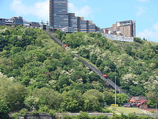
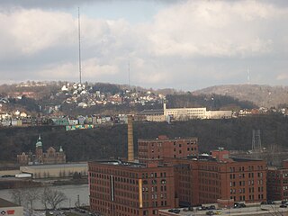
Mount Washington is a neighborhood in Pittsburgh, Pennsylvania's south city area. It has a zip code of 15211 and has representation on Pittsburgh City Council by both the council members for District 3 and District 2.
