South Side Flats (Pittsburgh)

Last updated
South Side Flats
Pgh locator southside flats.svg
Country United States
State Pennsylvania
County Allegheny County
City Pittsburgh
Area
[1]
  Total0.94 sq mi (2.4 km2)
Population
 (2000) [1]
  Total5,726
  Density6,100/sq mi (2,400/km2)
East Carson Street Historic District
EastCarsonStreetHistoricDistrict.jpg
East Carson and 13th in 2008.
Pittsburgh locator map 2018.png
Red pog.svg
USA Pennsylvania location map.svg
Red pog.svg
Usa edcp location map.svg
Red pog.svg
LocationRoughly E. Carson St. from 9th to 24th St., Pittsburgh, Pennsylvania
Coordinates 40°25′43.76″N79°59′8.08″W / 40.4288222°N 79.9855778°W / 40.4288222; -79.9855778 Coordinates: 40°25′43.76″N79°59′8.08″W / 40.4288222°N 79.9855778°W / 40.4288222; -79.9855778
Built1850
ArchitectMultiple
Architectural styleItalianate, Romanesque, Second Empire
NRHP reference No. 83004183 [2]
Significant dates
Added to NRHPNovember 17, 1983
Designated CPHSAugust 16, 1993, and expanded June 1999 [3]

The South Side Flats is a neighborhood in Pittsburgh, Pennsylvania's South Side area. It is located just south of the Monongahela River. The neighborhood has one of the City of Pittsburgh's largest concentrations of 19th-century homes, which has prompted outsiders to call the neighborhood the City's Georgetown. [4] It includes many bars and restaurants as well as residences. The main throughway in the South Side Flats is East Carson Street. The street is home to a significant portion of Pittsburgh's nightlife.

Contents

History

The South Side was once composed of a number of smaller communities. These included Birmingham and East Birmingham, both named for the English Midlands industrial center, Birmingham; Ormsby, originally a part of East Birmingham, incorporated as a borough in 1866; South Pittsburgh, the area immediately adjacent to the Smithfield Street Bridge, and Monongahela, named for the adjacent Monongahela River. These boroughs were collectively annexed to the city in 1872. [5]

The South Side and much of the hillsides to its south had been granted to Major John Ormsby in 1763, in recognition his assistance in the building of Fort Pitt. By the 1770s, Ormsby had built an estate on these lands and established a ferry for connecting his home with the community in Pittsburgh.

In 1811, Ormsby's son-in-law, Dr. Nathaniel Bedford, laid out a town on the flats, naming it Birmingham in tribute to his native city. Bedford had come to Pittsburgh around 1770 and was the first practicing physician in the district known as Allegheny County. [6] He named the streets after his Ormsby's children; names which the South Side streets still bear—Mary, Jane, Sarah, Sidney. Carson St. was named after a sea captain who lived in Philadelphia and was a friend of Dr. Bedford. In the early days it was part of the Washington Pike, the main road to Washington, Pennsylvania. The nearby municipality of Mount Oliver would be named for John Ormsby's son Oliver Ormsby. The two areas were once connected by a coal incline run by the Keeling Coal Company, now the site of South Side Park. Birmingham quickly became a sizable industrial center because of the easy access to river and rail transport. The region would first become a center of glass production, followed by a concentration of iron and steel manufacturing. In 1850, Benjamin Franklin Jones invested in a South Side iron works. During the depression of 1873, he formed a partnership with a banker, James H. Laughlin. The firm of Jones and Laughlin Steel Company would eventually become the South Side's largest employer. By 1910, it would employ over 15,000 workers. The expansion of the plant in 1950 would require the demolition of residential homes between 31st and 33rd streets. [7]

The majority of workers who had settled in the area were immigrants of Eastern Europe. They found home throughout the Flats and Slopes of South Side and had brought much of their culture and traditions to the area. Many of the Eastern European churches, clubs and bars are still present in the South Side.

The decline of the steel industry was a major blow to the neighborhood. In addition to layoffs at the J&L Plant, the Levinson Steel Company which had been located on the South Side closed in 1981. [8] The facility had been located along the river between 19th to 21st streets, and was later converted into a strip mall.

A series of arsons hit the South Side neighborhood in the early 1980s. [9] Prominent buildings on the corner of 18th and Carson Streets and the Arcade Theater on Carson St. were also demolished by fire. [10] The Arcade Theater had opened in 1929 and was the first theatre outside of Downtown Pittsburgh to have sound and air-conditioning. A Rite Aid pharmacy sits on the site of the theater. [11]

The early 1980s saw the beginnings of redevelopment on the South Side. The Pittsburgh History and Landmarks Foundation helped establish and partner with the South Side Local Development Company in 1982. In 1985, the South Side's East Carson Street was selected to participate in the National Trust for Historic Preservation's Main Street Urban Demonstration Program. Community involvement played a major role in the redevelopment of the former J&L site.

The Jones and Laughlin Company had merged with the Ling-Temco-Vought (LTV) Corporation in 1974. The company would merge its J&L Steel subsidiary with Republic Steel to form LTV Steel in 1984. The South Side J&L/LTV plant shut down in 1986. Once closed, City of Pittsburgh Councilman Otis Lyon wanted the site's Bessemer converter building, an open hearth building, four smokestacks, and a J&L sign to be preserved. The plan fell through when it was determined that these structures posed a safety hazard, although the J&L sign is mothballed beneath the Panhandle Bridge for future use. Riverboat gambling was considered for the site and in 1993, and the City of Pittsburgh Urban and Redevelopment Authority (URA) purchased the site with money loaned by a potential developer for $9.3 million. [12] The URA eventually redeveloped the site to be the Southside Works complex. The project has brought national retailers to the eastern end of the neighborhood. [13]

Geography

The South Side Flats is located at 40°25′43.76″N 79°59′8.08″W and covers 0.936 square miles (2.42 km2). [1]

The South Side Riverfront Park runs the majority of the border of the Flats to the Monongahela River. It hosts a myriad of events, like the annual Pittsburgh Dragon Boat Festival. [14] The Three Rivers Heritage Trail also runs through the park.

Surrounding and adjacent neighborhoods

The east-west section of the South Side Flats are bordered by the Pittsburgh neighborhoods of South Shore to the west and South Side Slopes to the south. The Flats then curve to follow a north-south direction; this segment is bordered by the Pittsburgh neighborhood of Arlington to the west and a very small section of Baldwin to the south.

The Flats run adjacent to three Pittsburgh neighborhoods across the Monongahela River and are directly linked via bridges. The Birmingham Bridge connects the Flats with the Bluff to the west. The north end of the Hot Metal Bridge connects the Flats with South Oakland to the northeast (left turn at end of bridge) and Hazelwood to the east (right turn). [15]

Demographics

Historical population
YearPop.±%
1940 22,476    
1950 17,942−20.2%
1960 12,586−29.9%
1970 9,260−26.4%
1980 7,894−14.8%
1990 6,177−21.8%
2000 5,726−7.3%
2010 6,597+15.2%
[16] [17]
Source: University of Pittsburgh [18]

According to the 2000 census, [1] there were 5,726 people living in the neighborhood and 3,613 total housing units within its boundaries. The racial makeup of the neighborhood was 95.2% White, 2.6% African American, 0.2% Native American, 0.7% Asian, 0.1% Pacific Islander, 0.2% from other races, and 1.0% from two or more races. Hispanics and Latinos of any race were 1.3% of the population.

Out of the total number of housing units, 86.7% were occupied. There were 9.2% of households with those under the age of 18 and 31.0% with those over the age of 65.

The population of the South Side Flats increased from 2000 to 2010, and much of the demographics did as well as a result of gentrification. Households with those over the age of 65 decreased from 31% in 2000 to just 11.8% in 2010. [19]

According to the 2010 census, [19] there were 6,597 people living in the neighborhood and 4,326 total housing units within its boundaries. The racial makeup of the neighborhood was 93.0% White, 3.0% African American, 0.1% Native American, 2.2% Asian, 0.0% Pacific Islander, 0.4% from other races, and 1.2% from two or more races. Hispanics and Latinos of any race were 2.5% of the population.

Out of the total number of housing units, 87.3% were occupied. 66.8% were renter occupied units, while nearly half of the vacant properties were listed for rent or rented but not occupied. [19]

Trivia

Kaufmanns Department Store was founded as a tailor shop on Carson St. on the South Side in 1871. [20]

The South Side had the first electric railway in the City of Pittsburgh. The line started at 13th and Carson and traveled to Mount Oliver Borough. [21]

The base of the Knoxville Incline was at 12th Street on the South Side. The incline was built in 1890, had an 18-degree curve, and was the longest incline ever built in Pittsburgh. [22]

Related Research Articles

Hazelwood (Pittsburgh) Neighborhood of Pittsburgh in Allegheny County, Pennsylvania, United States

Hazelwood is a neighborhood of Pittsburgh, Pennsylvania in the United States. It is represented on Pittsburgh City Council by Corey O'Connor. It is bordered by Greenfield and Oakland on the north, Squirrel Hill and Glen Hazel on the east, and the Monongahela River on the south and west. The Pittsburgh Bureau of Fire houses 13 Engine and 13 Truck in Hazelwood.

Downtown Pittsburgh Neighborhood of Pittsburgh in Allegheny County, Pennsylvania, United States

Downtown Pittsburgh, colloquially referred to as the Golden Triangle, and officially the Central Business District, is the urban downtown center of Pittsburgh. It is located at the confluence of the Allegheny River and the Monongahela River whose joining forms the Ohio River. The "triangle" is bounded by the two rivers. The area features offices for major corporations such as PNC Bank, U.S. Steel, PPG, Bank of New York Mellon, Heinz, Federated Investors and Alcoa. It is where the fortunes of such industrial barons as Andrew Carnegie, Henry Clay Frick, Henry J. Heinz, Andrew Mellon and George Westinghouse were made. It contains the site where the French fort, Fort Duquesne, once stood.

Uptown Pittsburgh Neighborhood of Pittsburgh in Allegheny County, Pennsylvania, United States

Uptown or The Bluff is a neighborhood in the city of Pittsburgh, Pennsylvania to the southeast of the city's Central Business District. It is bordered in the north by the Hill District and located across the Monongahela River from South Side. The predominant area zip code is 15219.

South Side (Pittsburgh) Neighborhoods of Pittsburgh in Allegheny, Pennsylvania, United States

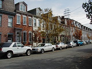
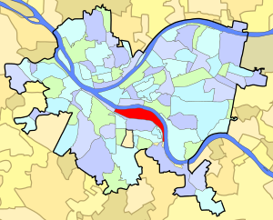
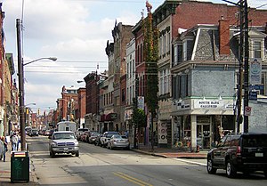
South Side is an area in Pittsburgh, Pennsylvania, United States, located along the Monongahela River across from Downtown Pittsburgh. The South Side is officially divided into two neighborhoods, South Side Flats and South Side Slopes. Both the Flats and the Slopes are represented on Pittsburgh City Council by Bruce Kraus. The business district stretches along East Carson Street, which is home to many small shops, restaurants and bars. In 2006, more than 80 bars and pubs operated in the South Side Flats. The neighborhood has an urban fabric with rowhouses.

Jones and Laughlin Steel Company Steel company south of Pittsburgh along the Monongahela River

The Jones and Laughlin Steel Company began as the American Iron Company, founded in 1852 by Bernard Lauth and B. F. Jones, a few miles south of Pittsburgh along the Monongahela River. Lauth's interest was bought in 1854 by James Laughlin. The first firm to bear the name of Jones and Laughlin was organized in 1861 and headquartered at Third & Ross in downtown Pittsburgh.

Carrick (Pittsburgh) Place in Pennsylvania, United States

Carrick is a south neighborhood of Pittsburgh, Pennsylvania in the United States. It is served by two zip codes, 15210 and 15227, and has representation on Pittsburgh City Council by the council member for District 4 with a part in District 3.

Knoxville (Pittsburgh) Neighborhood of Pittsburgh in Allegheny County, Pennsylvania, United States

Knoxville is a neighborhood in southern Pittsburgh, Pennsylvania. It is part of zip code 15210, and has representation on Pittsburgh City Council by the council member for District 3.

Duquesne Incline

The Duquesne Incline is a funicular located near Pittsburgh's South Side neighborhood and scaling Mt. Washington in Pittsburgh, Pennsylvania, United States. Designed by Hungarian-American engineer Samuel Diescher, the incline was completed in 1877.

Monongahela Incline Funicular railway in Pittsburgh, Pennsylvania

The Monongahela Incline is a funicular located near the Smithfield Street Bridge in Pittsburgh, Pennsylvania. Designed and built by Prussian-born engineer John Endres in 1870, it is the oldest continuously operating funicular in the United States.

Birmingham Bridge Bridge in Pittsburgh, Pennsylvania

The Birmingham Bridge is a bowstring arch bridge in Pittsburgh, Pennsylvania, which crosses over the Monongahela River. The bridge connects East Carson Street on the South Side with Fifth and Forbes Avenues going to Uptown, Oakland, and the Hill District. It is named in honor of the English city of Birmingham and also for the neighborhood it connects to, which was once called Birmingham, now a part of the South Side. Many locals also may refer to it with its unofficial name, the 22nd Street bridge.

Transportation in Pittsburgh Overview of transportation in Pittsburgh, Penssylvania, United States

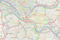
Pittsburgh, surrounded by rivers and hills, has a unique transportation infrastructure that includes roads, tunnels, bridges, railroads, inclines, bike paths, and stairways.

History of Pittsburghs South Side

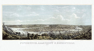
In 1763, King George III provided John Ormsby approximately 2,400 acres (9.7 km2) along the south bank of the Monongahela River as payment for his services during the French and Indian War. The land was then divided into four boroughs: South Pittsburgh, Birmingham, East Birmingham, and Ormsby. The four boroughs were annexed into the City of Pittsburgh in 1872. These areas, collectively, provided for the foundation of the South Side as it is known today.

South Side Slopes, Pittsburgh Neighborhood of Pittsburgh in Allegheny County, Pennsylvania, United States

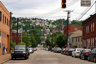
South Side Slopes is a neighborhood in Pittsburgh, Pennsylvania's South Side area. The neighborhood comprises the hills from the South Side Flats neighborhood along the Monongahela River from the Liberty Bridge (west) to beyond Josephine Street (east).

South Shore (Pittsburgh) Neighborhood of Pittsburgh in Allegheny County, Pennsylvania, United States

The South Shore is a neighborhood in Pittsburgh, Pennsylvania South Side. The South Shore consists of the area surrounding Carson Street, from the West End Bridge to the Liberty Bridge.

Bedford School (Pittsburgh, Pennsylvania) United States historic place

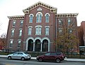
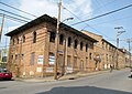
Bedford School, located at 910 Bingham Street in the historic South Side Flats neighborhood of Pittsburgh, Pennsylvania, has been listed in the National Register of Historic Places since 1986. According to Pittsburgh History and Landmarks Foundation, it is the oldest public school building still standing within the city of Pittsburgh.

The Whitehall Branch was a rail line owned and operated by the Pennsylvania Railroad in the U.S. state of Pennsylvania. The line ran from Monongahela Branch near the 30th Street yard to a connection with the Pittsburgh and Lake Erie Railroad and the Allegheny and South Side Railway at 21st Street Yard in the South Side of Pittsburgh. The line was abandoned by Conrail and has been removed.

John Ormsby (1720–1805) was a soldier in the French and Indian War, Pontiac's Rebellion, and the American Revolution, and among the first settlers of Pittsburgh, Pennsylvania. The son of the Anglo-Irish landed gentry, he emigrated from Ireland to the Thirteen Colonies in 1752. After Pontiac's Rebellion, he received a land grant from King George III, and established a homestead on the banks of the Monongahela River. He established extensive economic and merchant interests in Bedford, Pennsylvania, and at the head of the Ohio River.

The Keeling Coal Company (1861-1878) was a 19th-century coal mining company in Allegheny County, Pennsylvania. Its mines were located in the Pittsburgh Coalfield of western Pennsylvania.

Birmingham was a borough in Allegheny County, Pennsylvania, on the South Side of what is now Pittsburgh. Incorporated in 1826 from St. Clair Township, the borough comprised a section of the South Side Flats between what is now South 6th and South 17th Streets.

References

  1. 1 2 3 4 "Census: Pittsburgh" (PDF). Pittsburgh Department of City Planning. January 2006. Archived from the original (PDF) on 2007-08-10. Retrieved 2007-07-19.
  2. "National Register Information System". National Register of Historic Places . National Park Service. March 13, 2009.
  3. "Local Historic Designations". Pittsburgh, PA: Pittsburgh History & Landmarks Foundation. Retrieved 2011-07-30.
  4. Delahan, William (1966-06-12), "Renaissance On The South Side", Pittsburgh Press
  5. "An Atlas of the South Side Neighborhood of Pittsburgh 1977", Pittsburgh Neighborhood Atlas, Pittsburgh Neighborhood Alliance
  6. Killikelly, Sarah H. (1906). The History of Pittsburgh. Its Rise and Progress. B.C. & Gordon Montgomery Co. p. 356.
  7. Batz, Bob (1999-09-21), "Sweet memories. Former residents gather to remember a South Side neighborhood razed in 1950", Pittsburgh Post-Gazette
  8. "Southside landmarks to fall". Pittsburgh Post-Gazette. 1984-06-11.
  9. Perlmutter, Ellen M. (1984-06-17). "Portrait of an arsonist". Pittsburgh Press. pp. A1.
  10. Pittsburgh History and Landmarks Foundation. "Research: Spotlight on Main Street: Fatheads" . Retrieved 2007-04-04.
  11. Cinema Treasures. "Cinema Treasures Arcade Theater" . Retrieved 2007-04-04.
  12. The Western Pennsylvania Brownfields Center. "Background Information LTV South Side Works" . Retrieved 2007-04-04.
  13. O’Toole, Christine (2006-10-29). "Pittsburgh's South Side, Resurrected". Washington Post.
  14. , Pittsburgh Dragon Boat Festival. Retrieved 2010-11-21
  15. , map of South Side Flats. Retrieved 2010-11-21
  16. "PGHSNAP - Neighborhoods: All Raw Data".
  17. "Census:Pittsburgh" (PDF). Archived from the original (PDF) on August 10, 2007. Retrieved 2 September 2012.[ better source needed ]
  18. "Pittsburgh Census Tracts". pitt.libguides.com. Retrieved January 2, 2018.
  19. 1 2 3 http://ucsur.pitt.edu/wp-content/uploads/2014/11/UCSUR_SF1_NeighborhoodProfiles_July2011.pdf [ bare URL PDF ]
  20. Stouffer, Rick (2005-03-05). "'Kaufmann's is gone,' analyst predicts". Pittsburgh Tribune Review.
  21. South Pittsburgh Development Company. "Pittsburgh's Trolley History" . Retrieved 2007-04-04.
  22. South Side Local Development Company. "Pittsburgh's Inclines" (PDF). Archived from the original (PDF) on 2008-12-03. Retrieved 2007-04-04.

See also