National Register of Historic Places listings in Southwest Philadelphia

Last updated
Location of Southwest Philadelphia in Philadelphia SWPhilaDistrict.PNG
Location of Southwest Philadelphia in Philadelphia

This is a list of the National Register of Historic Places listings in Southwest Philadelphia.

Contents

This is intended to be a complete list of the properties and districts on the National Register of Historic Places in Southwest Philadelphia, Pennsylvania, United States. The locations of National Register properties and districts for which the latitude and longitude coordinates are included below may be seen in a Google map. [1]

National Register of Historic Places federal list of historic sites in the United States

The National Register of Historic Places (NRHP) is the United States federal government's official list of districts, sites, buildings, structures, and objects deemed worthy of preservation for their historical significance. A property listed in the National Register, or located within a National Register Historic District, may qualify for tax incentives derived from the total value of expenses incurred preserving the property.

Southwest Philadelphia Neighborhood of Philadelphia in Philadelphia, Pennsylvania

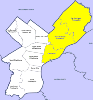
Southwest Philadelphia is a section of Philadelphia, Pennsylvania, United States. The section can be described as extending from the western side of the Schuylkill River to the city line, with the SEPTA. The northern border is defined by the Philadelphia City Planning Commission as east from the city line along Baltimore Avenue moving south along 51st Street to Springfield Ave. It follows the train tracks until 49th Street. From 49th and Kingsessing Ave the line moves east along Kingsessing Ave. The line then moves south along 46th St to Paschall Ave where it jogs to join Grays Ferry where the line runs to the Schuylkill River.

Philadelphia Largest city in Pennsylvania, United States

Philadelphia, known colloquially as Philly, is the largest city in the U.S. state and Commonwealth of Pennsylvania, and the sixth-most populous U.S. city, with a 2018 census-estimated population of 1,584,138. Since 1854, the city has been coterminous with Philadelphia County, the most populous county in Pennsylvania and the urban core of the eighth-largest U.S. metropolitan statistical area, with over 6 million residents as of 2017. Philadelphia is also the economic and cultural anchor of the greater Delaware Valley, located along the lower Delaware and Schuylkill Rivers, within the Northeast megalopolis. The Delaware Valley's population of 7.2 million ranks it as the eighth-largest combined statistical area in the United States.

There are 562 properties and districts listed on the National Register in Philadelphia, including 67 National Historic Landmarks. Southwest Philadelphia includes 12 of these properties and districts, including 2 National Historic Landmarks; the city's remaining properties and districts are listed elsewhere.

Map all coordinates using: OpenStreetMap  ·  Google Maps
Download coordinates as: KML  ·  GPX

Current listings

[2] Name on the Register Image Date listed [3] Location Neighborhood Description
1 John Bartram High School
John Bartram High School Bartram HS Philly.JPG
John Bartram High School
December 4, 1986
(#86003263)
67th and Elmwood Streets
39°55′16″N75°13′58″W / 39.9211°N 75.2328°W / 39.9211; -75.2328 (John Bartram High School)
Middle Southwest
2 John Bartram House
John Bartram House Bartram House May 2002c.jpg
John Bartram House
October 15, 1966
(#66000676)
54th Street and Eastwick Avenue
39°55′54″N75°12′43″W / 39.9317°N 75.2119°W / 39.9317; -75.2119 (John Bartram House)
Bartram Village
3 Joseph W. Catharine School
Joseph W. Catharine School Catherine School SW Philly.JPG
Joseph W. Catharine School
November 18, 1988
(#88002253)
6600 Chester Avenue
39°55′39″N75°14′23″W / 39.9275°N 75.2397°W / 39.9275; -75.2397 (Joseph W. Catharine School)
Mount Moriah
4 Fort Mifflin
Fort Mifflin Fort Mifflin 01.jpg
Fort Mifflin
August 29, 1970
(#70000554)
Fort Mifflin and Hog Island Roads [4]
39°52′31″N75°12′47″W / 39.8753°N 75.2131°W / 39.8753; -75.2131 (Fort Mifflin)
Philadelphia International Airport
5 Fort Mifflin Hospital
Fort Mifflin Hospital Mifflin Hospital03.png
Fort Mifflin Hospital
September 29, 1969
(#69000157)
Fort Mifflin and Hog Island Road [4]
39°52′35″N75°12′41″W / 39.8765°N 75.2113°W / 39.8765; -75.2113 (Fort Mifflin Hospital)
Philadelphia International Airport
6 S. Weir Mitchell School
S. Weir Mitchell School Mitchel School Philly.JPG
S. Weir Mitchell School
December 4, 1986
(#86003309)
56th and Kingsessing Street
39°56′12″N75°13′25″W / 39.9368°N 75.2237°W / 39.9368; -75.2237 (S. Weir Mitchell School)
Kingsessing
7 John M. Patterson School
John M. Patterson School Patterson School Philly.JPG
John M. Patterson School
November 18, 1988
(#88002305)
7001 Buist Avenue
39°54′58″N75°14′12″W / 39.9161°N 75.2367°W / 39.9161; -75.2367 (John M. Patterson School)
Penrose
8 Thomas Buchanan Read School
Thomas Buchanan Read School TB Read School Philly.JPG
Thomas Buchanan Read School
December 4, 1986
(#86003325)
78th Street and Buist Avenue
39°54′23″N75°14′52″W / 39.9065°N 75.2478°W / 39.9065; -75.2478 (Thomas Buchanan Read School)
Elmwood Park
9 Regent-Rennoc Court
Regent-Rennoc Court Regent Rennoc Court.JPG
Regent-Rennoc Court
September 12, 1985
(#85002292)
5100 block of Regent Street and 1311–1327 South 52nd Street
39°56′29″N75°13′09″W / 39.9414°N 75.2192°W / 39.9414; -75.2192 (Regent-Rennoc Court)
Southwest Schuylkill
10 Anna Howard Shaw Junior High School
Anna Howard Shaw Junior High School Shaw School Philly.JPG
Anna Howard Shaw Junior High School
November 18, 1988
(#88002321)
5401 Warrington Street
39°56′30″N75°13′35″W / 39.9417°N 75.2264°W / 39.9417; -75.2264 (Anna Howard Shaw Junior High School)
Southwest Schuylkill
11 William J. Tilden Junior High School
William J. Tilden Junior High School Tilden Jr HS 2.JPG
William J. Tilden Junior High School
December 1, 1986
(#86003337)
66th Street and Elmwood Avenue
39°55′18″N75°13′56″W / 39.9217°N 75.2322°W / 39.9217; -75.2322 (William J. Tilden Junior High School)
Paschall
12 George Wolf School
George Wolf School G Wolf School Philly.JPG
George Wolf School
November 18, 1988
(#88002243)
8100 Lyons Avenue
39°53′55″N75°14′46″W / 39.8986°N 75.246°W / 39.8986; -75.246 (George Wolf School)
Hedgerow

See also

Related Research Articles

National Register of Historic Places listings in Delaware County, Pennsylvania Wikimedia list article

This is a list of the National Register of Historic Places listings in Delaware County, Pennsylvania.

National Register of Historic Places listings in York County, Pennsylvania Wikimedia list article

This is a list of the National Register of Historic Places listings in York County, Pennsylvania.

National Register of Historic Places listings in Dauphin County, Pennsylvania Wikimedia list article

This is a list of the National Register of Historic Places listings in Dauphin County, Pennsylvania.

National Register of Historic Places listings in Pittsburgh, Pennsylvania Wikimedia list article

This is a list of the National Register of Historic Places listings in Pittsburgh, Pennsylvania.

National Register of Historic Places listings in Armstrong County, Pennsylvania Wikimedia list article

This is a list of the National Register of Historic Places listings in Armstrong County, Pennsylvania.

National Register of Historic Places listings in Bedford County, Pennsylvania Wikimedia list article

This is a list of the National Register of Historic Places listings in Bedford County, Pennsylvania.

National Register of Historic Places listings in Bradford County, Pennsylvania Wikimedia list article

This is a list of the National Register of Historic Places listings in Bradford County, Pennsylvania.

National Register of Historic Places listings in Carbon County, Pennsylvania Wikimedia list article

This is a list of the National Register of Historic Places listings in Carbon County, Pennsylvania.

National Register of Historic Places listings in Centre County, Pennsylvania Wikimedia list article

This is a list of the National Register of Historic Places listings in Centre County, Pennsylvania.

National Register of Historic Places listings in Potter County, Pennsylvania Wikimedia list article

This is a list of the National Register of Historic Places listings in Potter County, Pennsylvania.

National Register of Historic Places listings in Wyoming County, Pennsylvania Wikimedia list article

This is a list of the National Register of Historic Places listings in Wyoming County, Pennsylvania.

National Register of Historic Places listings in Tioga County, Pennsylvania Wikimedia list article

This is a list of the National Register of Historic Places listings in Tioga County, Pennsylvania.

National Register of Historic Places listings in Union County, Pennsylvania Wikimedia list article

This is a list of the National Register of Historic Places listings in Union County, Pennsylvania.

National Register of Historic Places listings in Center City, Philadelphia Wikimedia list article

This is a list of the National Register of Historic Places listings in Center City, Philadelphia.

National Register of Historic Places listings in North Philadelphia Wikimedia list article

This is a list of the National Register of Historic Places listings in North Philadelphia.

National Register of Historic Places listings in Northeast Philadelphia Wikimedia list article

This is a list of the National Register of Historic Places listings in Northeast Philadelphia.

National Register of Historic Places listings in Northwest Philadelphia Wikimedia list article

This is a list of the National Register of Historic Places listings in Northwest Philadelphia.

National Register of Historic Places listings in South Philadelphia Wikimedia list article

This is a list of the National Register of Historic Places listings in South Philadelphia.

National Register of Historic Places listings in West Philadelphia Wikimedia list article

This is a list of the National Register of Historic Places listings in West Philadelphia.

National Register of Historic Places listings in southern Chester County, Pennsylvania Wikimedia list article

This is a list of the National Register of Historic Places listings in southern Chester County, Pennsylvania.

References

  1. The latitude and longitude information provided in this table was derived originally from the National Register Information System, which has been found to be fairly accurate for about 99% of listings. For about 1% of NRIS original coordinates, experience has shown that one or both coordinates are typos or otherwise extremely far off; some corrections may have been made. A more subtle problem causes many locations to be off by up to 150 yards, depending on location in the country: most NRIS coordinates were derived from tracing out latitude and longitudes off of USGS topographical quadrant maps created under the North American Datum of 1927 , which differs from the current, highly accurate WGS84 GPS system used by most on-line maps. Chicago is about right, but NRIS longitudes in Washington are higher by about 4.5 seconds, and are lower by about 2.0 seconds in Maine. Latitudes differ by about 1.0 second in Florida. Some locations in this table may have been corrected to current GPS standards.
  2. Numbers represent an ordering by significant words. Various colorings, defined here, differentiate National Historic Landmarks and historic districts from other NRHP buildings, structures, sites or objects.
  3. The eight-digit number below each date is the number assigned to each location in the National Register Information System database, which can be viewed by clicking the number.
  4. 1 2 Location is derived from Fort Mifflin website; the NRIS lists the property at the intersection of Penrose Ferry Rd. with the nonexistent Marina Rd.