
Upper Moreland Township is a township in Montgomery County, Pennsylvania. The population was 24,015 at the 2010 census. Upper Moreland Township is a primarily residential community located about 13 miles outside Center City Philadelphia. It is made up of distinctive neighborhoods that are complemented by several thriving business, industrial, and commercial districts.
Byberry is a neighborhood in the far northeast section of Philadelphia, in the U.S. state of Pennsylvania. Originally it was incorporated as the Township of Byberry and was the northeasternmost municipality of Philadelphia County before the City and County were consolidated in 1854. Its approximate boundaries are the Poquessing Creek to the north, Woodhaven Road to the south, the Roosevelt Boulevard to the west, and Thornton Road to the east.
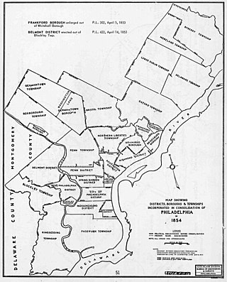
The Act of Consolidation, more formally known as the act of February 2, 1854, is legislation of the Pennsylvania General Assembly that created the consolidated City and County of Philadelphia, expanding the city's territory to the entirety of Philadelphia County and dissolving the other municipal authorities in the county.

Somerton is a neighborhood in the Far Northeast section of Philadelphia, Pennsylvania, United States. The neighborhood is bounded by Red Lion Road on the south, Roosevelt Boulevard on the east, East County Line Road and Poquessing Creek on the north, and the Philadelphia County / Montgomery County line on the west. Somerton is adjacent to the Philadelphia neighborhoods of Bustleton, Normandy, and Byberry, the townships of Bensalem and Lower Southampton in Bucks County, and Lower Moreland Township in Montgomery County. The area is home to a large and fast-growing foreign-born population, most notably of Russian, Ukrainian, Indian, and Central Asian immigrants.

Moyamensing is an area of Philadelphia established as a Moyamensing Township during British colonial rule on the fast land of the Neck, lying between Passyunk and Wicaco. It was incorporated into Philadelphia County, Pennsylvania, United States and today encompasses several neighborhoods along the Moyamensing Avenue corridor in the South Philadelphia section of Philadelphia.
Northern Liberties Township was a township that was located in Philadelphia County, Pennsylvania. The township was later incorporated into the City of Philadelphia after the passage of the Act of Consolidation, 1854.
Aramingo Borough was a borough that was located in Philadelphia County, Pennsylvania, United States. The borough ceased to exist and was incorporated into the City of Philadelphia following the passage of the Act of Consolidation, 1854.
Belmont District was a district that existed briefly in Philadelphia County, Pennsylvania, United States. The district was created on April 14, 1853 from northern Blockley Township ceased to exist and on February 2, 1854 the district was incorporated into the City of Philadelphia following the passage of the Act of Consolidation, 1854.

Blockley Township was a township that was located in Philadelphia County, Pennsylvania, United States. Incorporated in 1704, the township was incorporated into the City of Philadelphia under the 1854 Act of Consolidation.
Bristol Township was a township that was located in Philadelphia County, Pennsylvania, United States. The township ceased to exist and was incorporated into the City of Philadelphia following the passage of the Act of Consolidation, 1854. It is the modern day Olney-Oak Lane Planning Analysis Section, though with a slight difference in the southern border. It is in present-day North Philadelphia, although Olney-Oak Lane is sometimes considered to be separate from North Philadelphia entirely because of their unique architecture, culture and differing patterns of development.
Delaware Township was a township that was located in Philadelphia County, Pennsylvania, United States. The borough ceased to exist and was incorporated into the City of Philadelphia following the passage of the Act of Consolidation, 1854.
Germantown Township, also known as German Township, was a township that was located in Philadelphia County, Pennsylvania, United States. The municipality ceased to exist and was incorporated into the City of Philadelphia following the passage of the Act of Consolidation, 1854.

Oxford Township was a township in Philadelphia County, Pennsylvania, United States. The township ceased to exist and was incorporated into the City of Philadelphia following the passage of the Act of Consolidation, 1854.

Penn District was a district located in Philadelphia County, Pennsylvania, United States. The district ceased to exist and was incorporated into the City of Philadelphia following the passage of the Act of Consolidation, 1854.
Penn Township was a township that was located in Philadelphia County, Pennsylvania. The township ceased to exist and was incorporated into the City of Philadelphia following the passage of the Act of Consolidation, 1854.

Richmond District, also known as Port Richmond District, was a district that was located in Philadelphia County, Pennsylvania, United States. The district ceased to exist and was incorporated into the City of Philadelphia following the passage of the Act of Consolidation, 1854.
West Philadelphia Borough, also known as West Philadelphia District, was a borough that was located west of the Schuylkill River in Blockley Township, Philadelphia County, Pennsylvania, United States. The borough ceased to exist and was incorporated into the City of Philadelphia following the passage of the Act of Consolidation, 1854.
Whitehall Borough was a borough that was located in Philadelphia County, Pennsylvania, United States. The borough ceased to exist when it was incorporated into the City of Philadelphia on the passage of the Act of Consolidation, 1854.
Lower Dublin Township, also known as Dublin Township, was a township that was located in Philadelphia County, Pennsylvania, United States. The township ceased to exist and was incorporated into the City of Philadelphia following the passage of the Act of Consolidation, 1854.
Pennsylvania Route 63 (PA 63) is a 37.4-mile-long (60.2 km) state highway located in the Philadelphia, Pennsylvania, area. The western terminus of the route is at PA 29 in Green Lane, Montgomery County. The eastern terminus is at Interstate 95 (I-95) in Bensalem Township, Bucks County. PA 63 runs northwest to southeast for most of its length. The route heads through a mix of suburban and rural areas of northern Montgomery County as a two-lane road, passing through Harleysville, before coming to an interchange with I-476 in Kulpsville. From this point, PA 63 continues through predominantly suburban areas of eastern Montgomery County as a two- to four-lane road, passing through Lansdale, Maple Glen, Willow Grove, and Huntingdon Valley. Upon entering Northeast Philadelphia, the route follows Red Lion Road and U.S. Route 1 (US 1) before heading southeast on a freeway called Woodhaven Road to I-95.

