Morton, Philadelphia

Last updated
Morton
Fulton School Philly.JPG
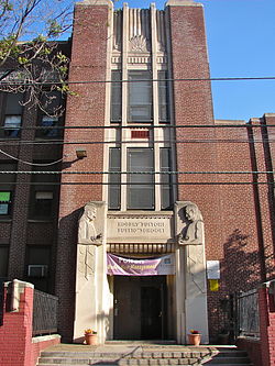
The Robert Fulton School in Morton, October 2010
Street map of Philadelphia and surrounding area.png
Red pog.svg
Morton
Coordinates: Coordinates: 40°03′04″N75°09′40″W / 40.051°N 75.161°W / 40.051; -75.161
CountryFlag of the United States.svg  United States
State Pennsylvania
County Philadelphia
City Philadelphia
Area code(s) 215, 267 and 445

Morton is a neighborhood in Northwest Philadelphia, Pennsylvania, United States. It is located south of West Oak Lane, east of Mount Airy, and west of North Broad Street. [1]

The Robert Fulton School, Mennonite Meetinghouse, and Theodore Roosevelt Junior High School are listed on the National Register of Historic Places. [2]

Related Research Articles

<span class="mw-page-title-main">Powelton Village, Philadelphia</span> United States historic place

Powelton Village is a neighborhood of mostly Victorian, mostly twin homes in the West Philadelphia section of the United States city of Philadelphia, Pennsylvania. It is a national historic district that is part of University City. It extends north from Market Street to Spring Garden Street, east to 32nd Street, west to 40th and Spring Garden Streets, and to 44th and Market Streets.

<span class="mw-page-title-main">Northern Liberties, Philadelphia</span> Former District in Pennsylvania, United States

Northern Liberties is a neighborhood in Philadelphia, Pennsylvania, United States. Prior to its incorporation into Philadelphia in 1854, it was among the top 10 largest cities in the U.S. in every census from 1790 to 1850.

<span class="mw-page-title-main">Overbrook, Philadelphia</span> Neighborhood of Philadelphia in Philadelphia County, Pennsylvania, United States

Overbrook is a neighborhood northwest of West Philadelphia, Philadelphia, in the U.S. state of Pennsylvania. The area's housing ranges from large, old homes to rowhouses to 3- and 4-story apartment buildings.

<span class="mw-page-title-main">Kensington, Philadelphia</span> Neighborhood in Philadelphia, Pennsylvania

Kensington, colloquially known locally as “Kenzo,” is a neighborhood in Philadelphia that belongs to or divides Lower Northeast and North Philadelphia. As with all neighborhoods in the city, the lack of any official designation means the boundaries of the area vary between sources over time and are disputed among locals. Kensington, as most long-term residents view it, refers generally to the area consisting of Kensington, East, or Lower Kensington, West Kensington, and Harrowgate. The adjacent Fairhill and Norris Square neighborhoods are more separate but may be included in Kensington; Fishtown and South (Olde) Kensington were previously included but have developed new identities with gentrification. The most conservative boundaries of the neighborhood, shown in the map below, are Front Street and 5th Street to the west, the Amtrak train tracks to the North, Trenton Avenue, the Trenton Avenue train tracks, and Frankford Avenue to the east, and Cecil B. Moore Avenue to the south.

<span class="mw-page-title-main">Mayfair, Philadelphia</span> Neighborhood of Philadelphia in Philadelphia County, Pennsylvania, United States

Mayfair is a working class neighborhood in lower Northeast Philadelphia, Pennsylvania, United States, centered on the intersection of Cottman and Frankford Avenues. It is bordered by Tacony and Wissinoming to the south and east, Holmesburg to the east, Pennypack Park to the north, and Oxford Circle and Rhawnhurst to the west. Mayfair is historically home to a large Irish American population, but more recently has seen accelerated growth of Asian American population

<span class="mw-page-title-main">Ogontz, Philadelphia</span> Neighborhood of Philadelphia in Philadelphia County, Pennsylvania, United States

Ogontz/Belfield is a neighborhood in Upper Northern Philadelphia that is located adjacent to West Oak Lane, East Germantown, Logan, and Fern Rock, Philadelphia.

<span class="mw-page-title-main">West Oak Lane, Philadelphia</span> Neighborhood of Philadelphia in Pennsylvania, United States

West Oak Lane is a neighborhood in the Northwest Philadelphia, Pennsylvania, United States. The neighborhood was developed primarily between the early 1920s and late 1930s, with the areas near to Cedarbrook constructed after World War II. At the northeast corner of Limekiln Pike and Washington Lane was the site of the Cedar Park Inn, a historic tavern built in the early 19th century, which was torn down sometime after 1931 as the neighborhood was being fully developed.

<span class="mw-page-title-main">West Kensington, Philadelphia</span> Neighborhood of Philadelphia in Philadelphia County, Pennsylvania, United States

West Kensington is a neighborhood in the North Philadelphia section of Philadelphia. It is north of Olde Kensington. The Market Frankford El above Front Street forms the line between West Kensington and Kensington. Its bordering neighborhoods are Kensington to the east, Hartranft, Philadelphia to the west, and Olde Kensington to the south. It is bounded by Front Street to the east, 6th Street to the west, Cecil B. Moore Avenue to the South and Lehigh Avenue to the north. It falls into the 19122 and 19133 ZIP Codes.

<span class="mw-page-title-main">Cobbs Creek, Philadelphia</span> Historic house in Pennsylvania, United States

Cobbs Creek is a neighborhood located in the West Philadelphia section of Philadelphia, Pennsylvania, United States, named for the creek which forms part of Philadelphia's western border. Cobbs Creek is generally bounded by Market Street to the north, Baltimore Avenue to the south, 52nd Street to the east, and the border of Upper Darby along Cobbs Creek to the West.

<span class="mw-page-title-main">Hartranft, Philadelphia</span> Neighborhood of Philadelphia, Pennsylvania, US

Hartranft is a neighborhood in the central part of North Philadelphia section of Philadelphia, Pennsylvania, United States.

<span class="mw-page-title-main">Hawthorne, Philadelphia</span> Neighborhood of Philadelphia in Philadelphia County, Pennsylvania, United States

Hawthorne is a neighborhood in the South Philadelphia section of Philadelphia, Pennsylvania. It is located between Broad Street and 11th Street, and extends from South Street to Washington Avenue.

<span class="mw-page-title-main">Logan Square, Philadelphia</span> Neighborhood of Philadelphia in Philadelphia County, Pennsylvania, United States

Logan Square is a neighborhood in Philadelphia. Bounded by Market Street on the south, Spring Garden Street on the north, Broad Street on the east, and the Schuylkill River on the west, it occupies the northwest quadrant of Center City. The square for which it is named is one of the five squares central to William Penn's design for Philadelphia. Originally called Northwest Square, it was renamed in honor of James Logan, an 18th-century mayor of Philadelphia.

<span class="mw-page-title-main">Haddington, Philadelphia</span> United States historic place

Haddington is a neighborhood in the West Philadelphia section of Philadelphia, Pennsylvania. Its borders are defined as Haverford Avenue/Girard Avenue to the north, 52nd Street to the east, Market Street to the south, and 67th Street to the most western edge of the neighborhood.

<span class="mw-page-title-main">Walnut Hill, Philadelphia</span> Neighborhood of Philadelphia in Philadelphia County, Pennsylvania, United States

Walnut Hill is a neighborhood in the West Philadelphia section of Philadelphia, Pennsylvania. It is located between 45th Street and 52nd Street, bounded by Market Street and Spruce Street. Most of the neighborhood is in the northwestern part of the University City District. It is located north of the neighborhoods of Garden Court and Spruce Hill.

<span class="mw-page-title-main">Parkside, Philadelphia</span> Historic house in Pennsylvania, United States

Parkside is a neighborhood in the West Philadelphia section of Philadelphia, Pennsylvania, USA. Much of the Parkside neighborhood was built during the 1876 Centennial Exhibition. It is a National Register of Historic Places Historic District with many examples of Victorian architecture, some well-preserved, others in poor condition. The neighborhood was populated by German Americans, followed by Eastern European Jews, before becoming heavily African American after World War II.

<span class="mw-page-title-main">Central South Philadelphia, Philadelphia</span> Neighborhood of Philadelphia in Philadelphia County, Pennsylvania, United States

Central South Philadelphia, commonly known as either just South Philadelphia or "South Philly," is a neighborhood in South Philadelphia. It is generally bounded by Broad to 9th Streets and Mifflin to Shunk. The entire neighborhood falls under the 19148 zip code. The neighborhood has a large Italian American population.

<span class="mw-page-title-main">Yorktown, Philadelphia</span> Neighborhood of Philadelphia in Philadelphia County, Pennsylvania, United States

Yorktown is a neighborhood in North Philadelphia. It is located north of Poplar and west of Ludlow. The James R. Ludlow School and William H. Harrison School were listed on the National Register of Historic Places in 1988.

<span class="mw-page-title-main">William Rowen School</span> United States historic place

William Rowen Elementary School is a historic elementary school located in the West Oak Lane neighborhood of Philadelphia, Pennsylvania. It is a part of the School District of Philadelphia.

<span class="mw-page-title-main">Parkway West High School (Pennsylvania)</span> United States historic place

Parkway West High School is a public magnet high school located in the Mill Creek neighborhood of Philadelphia, Pennsylvania. It shares a site with the Middle Years Alternative School for the Humanities (MYA). Both schools are part of the School District of Philadelphia.

<span class="mw-page-title-main">Belmont Charter School</span> United States historic place

The Belmont Charter School is an historic school building which is located in the Belmont neighborhood of Philadelphia, Pennsylvania.

References

  1. "Philadelphia Neighborhoods".
  2. "National Register Information System". National Register of Historic Places . National Park Service. July 9, 2010.