Fitler Square

Last updated
Fitler Square
Fitler Square.jpg
Fitler Square in Summer 2007
Street map of Philadelphia and surrounding area.png
Red pog.svg
Fitler Square
Coordinates: 39°56′51″N75°10′47″W / 39.94763°N 75.17973°W / 39.94763; -75.17973
CountryFlag of the United States (23px).png  United States
State Pennsylvania
County Philadelphia
City Philadelphia
Area code(s) 215, 267, and 445

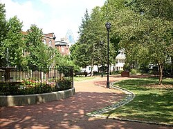
Fitler Square is a 0.5 acre (0.20 ha) public park in Philadelphia, Pennsylvania, United States and a surrounding neighborhood of the same name. The square is bounded on the east by 23rd Street, on the west by 24th Street, on the north by Panama Street, and on the south by Pine Street. The neighborhood encompasses much of southwest Center City west of Rittenhouse Square and east of the Schuylkill River.

Contents

Fitler Square was named for late 19th century Philadelphia mayor Edwin Henry Fitler shortly after his death in 1896. The square lies on land owned by the City of Philadelphia, via the Department of Parks and Recreation, [1] and is cared for through a public private partnership between the Department of Parks and Recreation and the Fitler Square Improvement Association. [2]

Neighborhood

Fitler Square, c. 1947 Fitler Square Circa 1947 A.jpg
Fitler Square, c.1947

The name Fitler Square is also used to describe the neighborhood surrounding the square, bounded roughly by 21st Street on the east, the Schuylkill River on the west, Locust Street on the north, and South Street on the south. To the east of this neighborhood is the Rittenhouse Square neighborhood; to the west is the University City neighborhood, home to the University of Pennsylvania and Drexel University; to the south is Southwest Center City (also known as "South of South" or the "Graduate Hospital Area"). The portion of Center City surrounding Fitler Square and nearby Rittenhouse Square is sometimes referred to as "Rit-Fit" after the two parks.[ citation needed ]

Before the 1950s, the neighborhood was a prime example of the urban blight that had overcome much of the city. The park itself was described as a "mudhole inhabited by drunks and empty bottles". [3] In the mid-1950s, The Center City Residents' Association successfully petitioned Mayor Clark to do something about the decline of the neighborhood. Working together, they freed up mortgage money for the construction of new homes and rehabilitation of the neighborhood. Also threatening the neighborhood was the proposed Crosstown Expressway. The threat of its construction, which would demolish much of the neighborhood, was enough to reduce property values and add to the neighborhood's blight. The Residents' Association was successful in changing these plans and in the following years the neighborhood drastically improved largely due to efforts of the Center City Residents' Association and the Fitler Square Improvement Association.

The neighborhood is mostly residential, composed of single-family homes[ citation needed ], and within a short walk of the commercial areas of Center City.

Sculptures

The fountain in Fitler Square Fitler Square 2.jpg
The fountain in Fitler Square

A sculpture of three turtles adorn the park made by Philadelphia artist Eric Berg along with sculptures of a Grizzly Bear and a Ram. The center of the park is dominated by a Victorian-era fountain which flows most of the year. Prior to 2010, this fountain, like many in Philadelphia, flowed fresh water from the main directly into the sewer system. In 2010, the Fitler Square Improvement Association engaged a large project at a cost of approximately $40,000 funded by neighborhood donations and a $7,000 grant from the Pennsylvania Horticultural Society to change the fountain into one that recirculates all of its water with a pumping system saving huge amounts of water each year.

Educational institutions

The Philadelphia School, a private institution, is located in the Fitler Square Neighborhood at 2501 Lombard St. The school, which originally opened in 1972, offers preschool through 8th grade classes. [4]

The Free Library of Philadelphia operates the Philadelphia City Institute on the first floor and lower level of an apartment complex at 1905 Locust Street. [5]

Notable people

Related Research Articles

<span class="mw-page-title-main">Fairmount Park</span> United States historic place

Fairmount Park is the largest municipal park in Philadelphia and the historic name for a group of parks located throughout the city. Fairmount Park consists of two park sections named East Park and West Park, divided by the Schuylkill River, with the two sections together totalling 2,052 acres (830 ha). Management of Fairmount Park and the entire citywide park system is overseen by Philadelphia Parks & Recreation, a city department created in 2010 from the merger of the Fairmount Park Commission and the Department of Recreation.

<span class="mw-page-title-main">Rittenhouse Square</span> Public park in Philadelphia, Pennsylvania, United States

Rittenhouse Square is a neighborhood, including a public park, in Center City Philadelphia, Pennsylvania. Rittenhouse Square often specifically refers to the park, while the neighborhood as a whole is referred to simply as Rittenhouse. The park is one of the five original open-space parks planned by William Penn and his surveyor Thomas Holme during the late 17th century.

<span class="mw-page-title-main">Washington Square West, Philadelphia</span> United States historic place

Washington Square West is a neighborhood in Center City, Philadelphia, Pennsylvania, United States. The neighborhood roughly corresponds to the area between 7th and Broad Streets and between Chestnut and South Streets, bordering on the Independence Mall tourist area directly northeast, Market East to the north, Old City and Society Hill to the East, Bella Vista directly south, Hawthorne to the southwest, and mid-town Philadelphia and Rittenhouse Square to the west. The area takes its name from Washington Square, a historic urban park in the northeastern corner of the neighborhood. In addition to being a desirable residential community, it is considered a hip, trendy neighborhood that offers a diverse array of shops, restaurants, and coffee houses. Washington Square West contains many gay-friendly establishments, especially in the gay village area of the neighborhood commonly known as the Gayborhood, which hosts annual events celebrating LGBT culture in Philadelphia, including OutFest.

<span class="mw-page-title-main">University City, Philadelphia</span> Neighborhood of Philadelphia in Philadelphia County, Pennsylvania, United States

University City is the easternmost portion of West Philadelphia, encompassing several Philadelphia universities. It is situated directly across the Schuylkill River from Center City.

<span class="mw-page-title-main">West Philadelphia</span> Neighborhood of Philadelphia, Pennsylvania

West Philadelphia, nicknamed West Philly, is a section of the city of Philadelphia. Although there are no officially defined boundaries, it is generally considered to reach from the western shore of the Schuylkill River, to City Avenue to the northwest, Cobbs Creek to the southwest, and the SEPTA Media/Wawa Line to the south. An alternate definition includes all city land west of the Schuylkill; this would also include Southwest Philadelphia and its neighborhoods. The eastern side of West Philadelphia is also known as University City.

<span class="mw-page-title-main">Center City, Philadelphia</span> Neighborhood in Philadelphia, Pennsylvania

Center City includes the central business district and central neighborhoods of Philadelphia, Pennsylvania, United States. It comprises the area that made up the City of Philadelphia prior to the Act of Consolidation, 1854, which extended the city borders to be coterminous with Philadelphia County.

<span class="mw-page-title-main">Brewerytown, Philadelphia</span> Historic house in Pennsylvania, United States

Brewerytown is a neighborhood in the North Philadelphia section of Philadelphia, Pennsylvania, United States. An unofficial region, Brewerytown runs approximately between the Schuylkill River's eastern bank and 25th Street, bounded by Montgomery Avenue to the north and Parrish Street to the south. Brewerytown derived its name from the numerous breweries that were located along the Schuylkill during the late 19th century and early 20th century. It is now primarily a residential neighborhood, with a growing and active commercial sector along Girard Avenue.

<span class="mw-page-title-main">South Street (Philadelphia)</span> Neighborhood of Philadelphia in Pennsylvania, United States

South Street in Philadelphia, originally named Cedar Street in William Penn's original street grid, is an east–west street forming the southern border of Center City and the northern border for South Philadelphia in Pennsylvania, United States.

<span class="mw-page-title-main">Logan Circle (Philadelphia)</span> United States historic place

Logan Circle, also known as Logan Square, is an open-space park in Center City Philadelphia's northwest quadrant and one of the five original planned squares laid out on the city grid. The centerpiece of the park is the Logan Circle, a circular area centered on a large water feature, bounded by a traffic circle carrying 19th Street and the Benjamin Franklin Parkway with connections to 18th and 20th streets to the east and west and Race and Vine Streets to the south and north.

<span class="mw-page-title-main">Southwest Center City Philadelphia</span> Neighborhood of Philadelphia in Philadelphia, Pennsylvania

Southwest Center City (SWCC), also known as Graduate Hospital, is a neighborhood that is located in South Philadelphia, Pennsylvania, United States, bordering Center City Philadelphia. The neighborhood is bordered on the north by South Street, on the south by Washington Avenue, on the west by the Schuylkill River, and on the east by Broad Street.

<span class="mw-page-title-main">Point Breeze, Philadelphia</span> Neighborhood of Philadelphia in Pennsylvania, United States

Point Breeze is a multicultural neighborhood in South Philadelphia in Philadelphia, Pennsylvania, United States. It is bounded by 25th Street to the west, Washington Avenue to the north, 18th Street to the east, and Moore Street to the south. Southwest Center City lies to its north. Passyunk Square and East Passyunk Crossing lie to its east. Point Breeze is separated from Grays Ferry to the west by a CSX railway viaduct over 25th Street.

<span class="mw-page-title-main">Grays Ferry, Philadelphia</span> Neighborhood of Philadelphia in Pennsylvania, United States

Grays Ferry, also known as Gray's Ferry, is a neighborhood in South Philadelphia, Pennsylvania, United States, bounded (roughly) by 25th Street on the east, the Schuylkill River on the west, Vare Avenue on the south, and Grays Ferry Avenue on the north. The section of this neighborhood west of 34th Street is also known as Forgotten Bottom.

<span class="mw-page-title-main">Logan Square, Philadelphia</span> Neighborhood of Philadelphia in Pennsylvania, United States

Logan Square is a neighborhood in Philadelphia, Pennsylvania, United States. Bounded by Market Street on the south, Spring Garden Street on the north, Broad Street on the east, and the Schuylkill River on the west, it occupies the northwestern quadrant of Center City. The square for which it is named is one of the five squares central to William Penn's design for Philadelphia. Originally called Northwest Square, it was renamed in honor of James Logan, an 18th-century mayor of Philadelphia.

<span class="mw-page-title-main">Wynnefield Heights, Philadelphia</span> Neighborhood of Philadelphia in Pennsylvania, United States

Wynnefield Heights is a middle class neighborhood that is located in the greater West Philadelphia area of Philadelphia, Pennsylvania, United States. The neighborhood is bounded by City Avenue to the north, Belmont Avenue to the west, Fairmount Park to the south and east, and the Schuylkill Expressway to the east.

<span class="mw-page-title-main">Angora, Philadelphia</span> Neighborhood of Philadelphia in Pennsylvania, United States

Angora is a neighborhood in the Southwest section of Philadelphia, Pennsylvania, United States. Although its boundaries are not precise, West Philadelphia is to its north, Kingsessing is to the south, Cedar Park is to the east, and Cobbs Creek is to the west. The Angora Commuter Rail Station on the Media/Wawa Line, two bus lines, and a trolley line all intersect around Baltimore Avenue and 58th Street, which is unofficially the nexus of the neighborhood.

<span class="mw-page-title-main">Franklin Square (Philadelphia)</span> United States historic place

Franklin Square is one of the five original open-space parks planned by William Penn when he laid out the city of Philadelphia, Pennsylvania, in 1682. It is located in the Center City area, between North 6th and 7th streets, and between Race Street and the Vine Street Expressway (I-676).

<span class="mw-page-title-main">Walnut Street (Philadelphia)</span> Street in Philadelphia, Pennsylvania, USA

Walnut Street is located in Center City Philadelphia and extends to the Delaware River waterfront and West Philadelphia. Walnut Street has been characterized as "the city's premier shopping district" by The Philadelphia Inquirer.

<span class="mw-page-title-main">East Passyunk Crossing, Philadelphia</span> Neighborhood of Philadelphia in Pennsylvania, United States

East Passyunk Crossing is a neighborhood in South Philadelphia, Pennsylvania, United States. Its location is considered to be from Tasker Street to Snyder Avenue and Broad Street to 6th Street.

Gentrification is the controversial process of affluent people moving into a historically low-income neighborhood. It is often criticized because the current residents have limited options to buy or rent equivalent housing in alternative areas at the same price. If they stay, prices for products, services, and taxes rise and existing social networks are disturbed. Gentrification is the opposite of white flight—when residents voluntarily move away as a neighborhood declines.

References

  1. Department of Parks and Recreation
  2. Fitler Square Improvement Association, Inc
  3. Lowe, Jeanne R., Cities in a Race With Time: Progress and Poverty in America's Renewing Cities, p 338, Random House NY, 1967
  4. "The Philadelphia School". Archived from the original on 2009-11-17. Retrieved 2009-10-20.
  5. "Philadelphia City Institute." Free Library of Philadelphia . Retrieved on January 20, 2009.