Fox Chase Farm

Last updated

Stanley
Fox Chase Farm Manor House 01.JPG
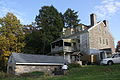
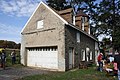
Fox Chase Farm Manor House. October 2012.
Street map of Philadelphia and surrounding area.png
Red pog.svg
USA Pennsylvania location map.svg
Red pog.svg
Usa edcp location map.svg
Red pog.svg
Location8500 Pine Rd., Philadelphia, Pennsylvania
Coordinates 40°5′26″N75°4′31″W / 40.09056°N 75.07528°W / 40.09056; -75.07528
Area112.3 acres (45.4 ha)
Built1822
ArchitectGlancy, Irvin
Architectural styleFederal, Stick/eastlake, et al.
NRHP reference No. 05000415 [1]
Added to NRHPMay 10, 2005

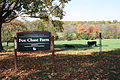
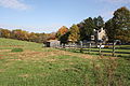
Fox Chase Farm is one of two working farms in the city of Philadelphia, Pennsylvania (W.B. Saul High School's Farm in Roxborough is the other). Formerly owned by the Wistar family, the farm is located on Pine Road in the Fox Chase neighborhood of Northeast Philadelphia on the border with Montgomery County. The farm gradually became surrounded by the city's residential neighborhoods and was purchased by the city in 1975. It is now run as an educational farm by the School District of Philadelphia. [2]

Contents

The farm was added to the National Register of Historic Places in 2005 under its old name of Stanley, a name it acquired when William Penn granted the land to Lord Stanley.

Related Research Articles

<span class="mw-page-title-main">Roxborough, Philadelphia</span> Neighborhood in Philadelphia, Pennsylvania, United States

Roxborough is a neighborhood in the Northwest section of the city of Philadelphia, Pennsylvania, United States. It is bordered to the southwest, along the Schuylkill River, by the neighborhood of Manayunk, along the northeast by the Wissahickon Creek section of Fairmount Park, and to the southeast by the neighborhood of East Falls. Beyond Roxborough to the northwest is Montgomery County. Roxborough's ZIP code is 19128. Most of Roxborough is in Philadelphia's 21st Ward.

<span class="mw-page-title-main">Fox Chase, Philadelphia</span> Neighborhood of Philadelphia in Philadelphia, Pennsylvania

Fox Chase is a neighborhood in Northeast Philadelphia, Pennsylvania, United States.

<span class="mw-page-title-main">Washington Square West, Philadelphia</span> United States historic place

Washington Square West is a neighborhood in Center City, Philadelphia, Pennsylvania, United States. The neighborhood roughly corresponds to the area between 7th and Broad Streets and between Chestnut and South Streets, bordering on the Independence Mall tourist area directly northeast, Market East to the north, Old City and Society Hill to the East, Bella Vista directly south, Hawthorne to the southwest, and mid-town Philadelphia and Rittenhouse Square to the west. In addition to being a desirable residential community, it is considered a hip, trendy neighborhood that offers a diverse array of shops, restaurants, and coffee houses. Washington Square West contains many gay-friendly establishments and hosts annual events celebrating LGBT culture in Philadelphia, including OutFest. The area takes its name from Washington Square, a historic urban park in the northeastern corner of the neighborhood.

<span class="mw-page-title-main">Fishtown, Philadelphia</span> Neighborhood of Philadelphia in Philadelphia County, Pennsylvania, United States

Fishtown is a neighborhood in the River Wards section of Philadelphia, Pennsylvania, United States. Located northeast of Center City Philadelphia, its borders are somewhat disputed today due to many factors, but are roughly defined by the triangle created by the Delaware River, Frankford Avenue, and York Street. Some newer residents expand the area to Lehigh Avenue, while some older residents shrink the area to Norris Street. It is served by the Market–Frankford Line rapid transit subway/elevated line of the SEPTA system. Fishtown is a largely working class Irish Catholic neighborhood, but has recently seen a large influx of young urban professionals and gentrification.

<span class="mw-page-title-main">Overbrook, Philadelphia</span> Neighborhood of Philadelphia in Philadelphia County, Pennsylvania, United States

Overbrook is an historic neighborhood that is located in the Commonwealth of Pennsylvania, United States. It is situated northwest of West Philadelphia, Philadelphia.

<span class="mw-page-title-main">Ogontz, Philadelphia</span> Neighborhood of Philadelphia in Pennsylvania, United States

Ogontz/Belfield is a neighborhood in Upper Northern Philadelphia that is located adjacent to West Oak Lane, East Germantown, Logan, and Fern Rock, Philadelphia, Pennsylvania, United States.

<span class="mw-page-title-main">Burholme, Philadelphia</span> Neighborhood of Philadelphia in Pennsylvania, United States

Burholme is a neighborhood in the Northeast section of Philadelphia, Pennsylvania, United States.

<span class="mw-page-title-main">Bustleton, Philadelphia</span> Neighborhood of Philadelphia in Philadelphia County, Pennsylvania, United States

The Bustleton section of Northeast Philadelphia, United States is located in the Far Northeast, north of Rhawnhurst and Fox Chase and south of Somerton; sitting between Roosevelt Boulevard to the east, the city boundary to the west, Red Lion Road to the north, and Pennypack Park to the south, it is centered at the intersection of Grant Avenue and Bustleton Avenue (PA-532) and is completely included in the 19115 postal ZIP code.

<span class="mw-page-title-main">Society Hill</span> United States historic place

Society Hill is a historic neighborhood in Center City Philadelphia, Pennsylvania, United States, with a population of 6,215 as of the 2010 United States Census. Settled in the early 1680s, Society Hill is one of the oldest residential neighborhoods in Philadelphia. After urban decay developed between the late 19th and early 20th centuries, an urban renewal program began in the 1950s, restoring the area and its many historic buildings. Society Hill has since become one of the most expensive neighborhoods with the highest average income and second-highest real estate values in Philadelphia. Society Hill's historic colonial architecture, along with planning and restoration efforts, led the American Planning Association to designate it, in 2008, as one of the great American neighborhoods and a good example of sustainable urban living.

<span class="mw-page-title-main">Overbrook Farms, Philadelphia</span> United States historic place

Overbrook Farms is a neighborhood that is situated on the western edge of the West Philadelphia section of Philadelphia, Pennsylvania, United States. It is roughly bounded by City Avenue, 58th Street, Woodbine Avenue, and 66th Street at Morris Park.

<span class="mw-page-title-main">Spring Garden, Philadelphia</span> Historic neighborhood in Pennsylvania, United States

Spring Garden is a neighborhood in central Philadelphia, Pennsylvania, United States, bordering Center City on the north. Spring Garden is a neighborhood that combines diverse residential neighborhoods and significant cultural attractions. The residential areas on the north side of the neighborhood are composed mostly of brick and brownstone three-story townhouses built during the mid-to-late 19th century. The houses include townhouses in the Italianate style, Second Empire, Queen Anne, and Venetian Gothic. Many streets include "terraced" set ups, which include a small gardened plot, often raised, in front of the house. The residential areas to the south are dominated by taller, multi-family buildings built during the 20th century. The museum area, also to the south of Spring Garden Street, includes the Rodin Museum, the Central Library of Philadelphia, and the Barnes Museum. Before consolidation of Philadelphia, Spring Garden was a district of Philadelphia County.

<span class="mw-page-title-main">Philadelphia Military Academy</span> School in Philadelphia, Pennsylvania, United States

The Philadelphia Military Academy (PMA) is a military school that is located in North Philadelphia, Pennsylvania. The school opened for the 2004–2005 school year as the Philadelphia Military Academy at Leeds in the East Mt Airy neighborhood of Philadelphia, with an enrollment of 157 ninth grade cadets.

<span class="mw-page-title-main">Booth Farm</span> Historic house in Pennsylvania, United States

The Booth Farm is a historic farmhouse located in Bethel Township, Delaware County. The farmhouse was built in the Federal style in 1819 and a barn was also built about the same time. The roughly 77 acre farm was bought by Thomas Booth in the 1790s and has been used as a tenant farm throughout much of its history. He built the farmhouse for his son James who was born in 1790. Four following generations, all named Thomas Booth, have owned the farm into the 21st century.

<span class="mw-page-title-main">James R. Ludlow School</span> United States historic place

The James R. Ludlow School is an historic American K-8 elementary school within the School District of Philadelphia. It is located in the Yorktown neighborhood of Philadelphia, Pennsylvania.

<span class="mw-page-title-main">David Wilmot School</span> United States historic place

The David Wilmot Public School For Coloured Children, also known as the J.C. King Educational Building, is located the Frankford neighborhood of Philadelphia, Pennsylvania. Built in 1874, it is a two-story, four bay, stone building in the Italianate-design presumably of Lewis H. Esler (1819-1883), a prominent architect employed by the Philadelphia Board of Public Education.

<span class="mw-page-title-main">George L. Horn School</span> United States historic place

The George L. Horn School is an historic school building which is located in the Harrowgate neighborhood of Philadelphia, Pennsylvania.

<span class="mw-page-title-main">Frances E. Willard School</span> United States historic place

Frances E. Willard School is an elementary school located in the Port Richmond neighborhood of Philadelphia, Pennsylvania. It is part of the School District of Philadelphia. The school is named for suffragist Frances Willard.

<span class="mw-page-title-main">Parkway West High School (Pennsylvania)</span> United States historic place

Parkway West High School is an American public magnet high school that is located in the Mill Creek neighborhood of Philadelphia, Pennsylvania. It shares a site with the Middle Years Alternative School for the Humanities (MYA). Both schools are part of the School District of Philadelphia.

<span class="mw-page-title-main">Federal Barn</span> United States historic place

Federal Barn, also known as the barn at Cressbrook Farm, is a historic barn located in Tredyffrin Township, Chester County, Pennsylvania. The barn was built in two sections; the older dated to 1792 and the second section to about 1840. It is a two-story., six bay, Pennsylvania bank barn. It is of fieldstone and frame construction and has a gable roof. The barn is located about 150 feet from Cressbrook Farm house.

<span class="mw-page-title-main">Springton Manor Farm</span> Historic district in Pennsylvania, United States

The Springton Manor Farm is an historic, American farm and national historic district that is located in Wallace Township, Chester County, Pennsylvania.

References

  1. "National Register Information System". National Register of Historic Places . National Park Service. July 9, 2010.
  2. "National Historic Landmarks & National Register of Historic Places in Pennsylvania". CRGIS: Cultural Resources Geographic Information System. Archived from the original (Searchable database) on July 21, 2007. Retrieved March 25, 2012.Note: This includes Jean K. Wolf (December 2004). "National Register of Historic Places Inventory Nomination Form: Stanley" (PDF). Retrieved March 25, 2012.