National Register of Historic Places listings in Sullivan County, Pennsylvania

Last updated
Location of Sullivan County in Pennsylvania Map of Pennsylvania highlighting Sullivan County.svg
Location of Sullivan County in Pennsylvania

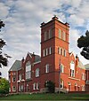
This is a list of the National Register of Historic Places listings in Sullivan County, Pennsylvania.

Contents

This is intended to be a complete list of the properties and districts on National Register of Historic Places in Sullivan County, Pennsylvania. The locations of National Register properties and districts for which the latitude and longitude coordinates are included below, may be seen in a map. [1]

National Register of Historic Places federal list of historic sites in the United States

The National Register of Historic Places (NRHP) is the United States federal government's official list of districts, sites, buildings, structures, and objects deemed worthy of preservation for their historical significance. A property listed in the National Register, or located within a National Register Historic District, may qualify for tax incentives derived from the total value of expenses incurred preserving the property.

Sullivan County, Pennsylvania County in the United States

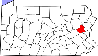
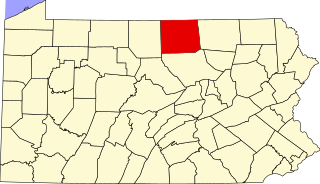
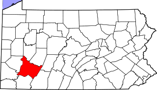
Sullivan County is a county located in the U.S. state of Pennsylvania. As of the 2010 census, the population was 6,428, making it the second-least populous county in Pennsylvania. Its county seat is Laporte. The county was created on March 15, 1847, from part of Lycoming County and named for Charles C. Sullivan, leader of the Pennsylvania Senate at that time.

There are 7 properties and districts listed on the National Register in the county.

This National Park Service list is complete through NPS recent listings posted October 11, 2018. [2]
Map all coordinates using: OpenStreetMap  
Download coordinates as: KML  ·  GPX

Current listings

[3] Name on the RegisterImageDate listed [4] Location City or townDescription
1 Eagles Mere Historic District
Eagles Mere Historic District Eagles Mere Historic District 10.JPG
Eagles Mere Historic District
June 28, 1996
(#96000718)
Roughly bounded by Pennsylvania Route 42, Borough boundary, Loyalsock State Forest and Eagles Mere Golf Club
41°25′02″N76°34′36″W / 41.417222°N 76.576667°W / 41.417222; -76.576667 (Eagles Mere Historic District)
Eagles Mere and Shrewsbury Township Boundary increase on September 18, 2013.
2 Forksville Covered Bridge
Forksville Covered Bridge Forksville Covered Bridge Narrow.jpg
Forksville Covered Bridge
July 24, 1980
(#80003639)
Legislative Route 56007 spur
41°29′18″N76°36′00″W / 41.488333°N 76.6°W / 41.488333; -76.6 (Forksville Covered Bridge)
Forksville
3 Hillsgrove Covered Bridge
Hillsgrove Covered Bridge Hillsgrove Covered Bridge 2.jpg
Hillsgrove Covered Bridge
July 2, 1973
(#73001666)
3 miles (4.8 km) east of Hillsgrove off Pennsylvania Route 87 over Loyalsock Creek
41°27′39″N76°40′17″W / 41.460833°N 76.671389°W / 41.460833; -76.671389 (Hillsgrove Covered Bridge)
Hillsgrove Township
4 Clemuel Ricketts Mansion
Clemuel Ricketts Mansion Clemuel Ricketts Mansion southwest.jpg
Clemuel Ricketts Mansion
June 9, 1983
(#83002284)
Off Pennsylvania Route 487
41°21′08″N76°19′14″W / 41.352222°N 76.320556°W / 41.352222; -76.320556 (Clemuel Ricketts Mansion)
Colley Township
5 Sonestown Covered Bridge
Sonestown Covered Bridge Sonestown Covered Bridge 12.jpg
Sonestown Covered Bridge
July 24, 1980
(#80003640)
South of Sonestown on Township 310
41°20′47″N76°33′19″W / 41.346389°N 76.555278°W / 41.346389; -76.555278 (Sonestown Covered Bridge)
Davidson Township
6 Sullivan County Courthouse
Sullivan County Courthouse Sullivan County Courthouse.jpg
Sullivan County Courthouse
December 15, 1978
(#78002472)
Main and Muncy Streets
41°25′25″N76°29′39″W / 41.423611°N 76.494167°W / 41.423611; -76.494167 (Sullivan County Courthouse)
Laporte
7 Worlds End State Park Family Cabin District
Worlds End State Park Family Cabin District Worlds End State Park Cabin 14.jpg
Worlds End State Park Family Cabin District
May 18, 1987
(#87000742)
2 miles (3.2 km) southeast of Forksville on Pennsylvania Route 154
41°28′02″N76°34′35″W / 41.467222°N 76.576389°W / 41.467222; -76.576389 (Worlds End State Park Family Cabin District)
Forks Township

See also

Related Research Articles

National Register of Historic Places listings in Delaware County, Pennsylvania Wikimedia list article

This is a list of the National Register of Historic Places listings in Delaware County, Pennsylvania.

National Register of Historic Places listings in York County, Pennsylvania Wikimedia list article

This is a list of the National Register of Historic Places listings in York County, Pennsylvania.

National Register of Historic Places listings in Lycoming County, Pennsylvania Wikimedia list article

This is a list of the National Register of Historic Places listings in Lycoming County, Pennsylvania.

National Register of Historic Places listings in Dauphin County, Pennsylvania Wikimedia list article

This is a list of the National Register of Historic Places listings in Dauphin County, Pennsylvania.

National Register of Historic Places listings in Pittsburgh, Pennsylvania Wikimedia list article

This is a list of the National Register of Historic Places listings in Pittsburgh, Pennsylvania.

National Register of Historic Places listings in Armstrong County, Pennsylvania Wikimedia list article

This is a list of the National Register of Historic Places listings in Armstrong County, Pennsylvania.

National Register of Historic Places listings in Bedford County, Pennsylvania Wikimedia list article

This is a list of the National Register of Historic Places listings in Bedford County, Pennsylvania.

National Register of Historic Places listings in Bradford County, Pennsylvania Wikimedia list article

This is a list of the National Register of Historic Places listings in Bradford County, Pennsylvania.

National Register of Historic Places listings in Carbon County, Pennsylvania Wikimedia list article

This is a list of the National Register of Historic Places listings in Carbon County, Pennsylvania.

National Register of Historic Places listings in Centre County, Pennsylvania Wikimedia list article

This is a list of the National Register of Historic Places listings in Centre County, Pennsylvania.

National Register of Historic Places listings in Crawford County, Pennsylvania Wikimedia list article

This is a list of the National Register of Historic Places listings in Crawford County, Pennsylvania.

National Register of Historic Places listings in Monroe County, Pennsylvania Wikimedia list article

This is a list of the National Register of Historic Places listings in Monroe County, Pennsylvania.

National Register of Historic Places listings in Potter County, Pennsylvania Wikimedia list article

This is a list of the National Register of Historic Places listings in Potter County, Pennsylvania.

National Register of Historic Places listings in Wyoming County, Pennsylvania Wikimedia list article

This is a list of the National Register of Historic Places listings in Wyoming County, Pennsylvania.

National Register of Historic Places listings in Tioga County, Pennsylvania Wikimedia list article

This is a list of the National Register of Historic Places listings in Tioga County, Pennsylvania.

National Register of Historic Places listings in Union County, Pennsylvania Wikimedia list article

This is a list of the National Register of Historic Places listings in Union County, Pennsylvania.

National Register of Historic Places listings in Westmoreland County, Pennsylvania Wikimedia list article

This is a list of the National Register of Historic Places listings in Westmoreland County, Pennsylvania.

National Register of Historic Places listings in Sullivan County, Indiana Wikimedia list article

This is a list of the National Register of Historic Places listings in Sullivan County, Indiana.

National Register of Historic Places listings in northern Chester County, Pennsylvania Wikimedia list article

This is a list of the National Register of Historic Places listings in northern Chester County, Pennsylvania.

National Register of Historic Places listings in Sullivan County, Missouri Wikimedia list article

This is a list of the National Register of Historic Places listings in Sullivan County, Missouri.

References

  1. The latitude and longitude information provided in this table was derived originally from the National Register Information System, which has been found to be fairly accurate for about 99% of listings. For about 1% of NRIS original coordinates, experience has shown that one or both coordinates are typos or otherwise extremely far off; some corrections may have been made. A more subtle problem causes many locations to be off by up to 150 yards, depending on location in the country: most NRIS coordinates were derived from tracing out latitude and longitudes from USGS topographical quadrant maps created under the North American Datum of 1927 , which differs from the current, highly accurate WGS84 GPS system used by most on-line maps. Chicago is about right, but NRIS longitudes in Washington are higher by about 4.5 seconds, and are lower by about 2.0 seconds in Maine. Latitudes differ by about 1.0 second in Florida. Some locations in this table may have been corrected to current GPS standards.
  2. https://www.nps.gov/subjects/nationalregister/weekly-list.htm "National Register of Historic Places: Weekly List Actions"]. National Park Service, United States Department of the Interior. Retrieved on October 11, 2018.
  3. Numbers represent an ordering by significant words. Various colorings, defined here, differentiate National Historic Landmarks and historic districts from other NRHP buildings, structures, sites or objects.
  4. The eight-digit number below each date is the number assigned to each location in the National Register Information System database, which can be viewed by clicking the number.