Elkland Township, Sullivan County, Pennsylvania

Last updated

Elkland Township, Pennsylvania
ET Backdrop.jpg
Pennsylvania Route 154 as it passes through the township with the Allegheny Plateau in the background
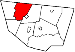
Map of Sullivan County Pennsylvania Highlighting Elkland Township.png
Map of Sullivan County, Pennsylvania highlighting Elkland Township
Map of Pennsylvania highlighting Sullivan County.svg
Map of Pennsylvania highlighting Sullivan County
Country United States
State Pennsylvania
County Sullivan
Settled1798
Incorporated1804
Area
[1]
  Total38.69 sq mi (100.21 km2)
  Land38.46 sq mi (99.61 km2)
  Water0.23 sq mi (0.60 km2)
Population
 (2020) [2]
  Total547 Decrease2.svg
  Estimate 
(2021) [2]
549
  Density14.14/sq mi (5.46/km2)
Time zone UTC-5 (Eastern (EST))
  Summer (DST) UTC-4 (EDT)
ZIP Code
18616
Area code 570
FIPS code 42-113-23144

Elkland Township is a township in Sullivan County, Pennsylvania, United States. The population was 547 at the 2020 census. [2]

Contents

Geography

According to the United States Census Bureau, the township has a total area of 38.7 square miles (100 km2), of which 38.46 square miles (99.6 km2) is land and 0.23 square miles (0.60 km2) (0.6%) is water.

Elkland Township is bordered by Bradford County to the north, Forks Township and Forksville to the east, Hillsgrove Township to the south and Fox Township to the west.

Demographics

Historical population
CensusPop.Note
2010 577
2020 547−5.2%
2021 (est.)549 [2] 0.4%
U.S. Decennial Census [3]

2010

At the 2010 census there were 577 people, 236 households, and 157 families in the township. The population density was 15 people per square mile (5.8 people/km2). There were 512 housing units at an average density of 13.3 per square mile (5.1/km2). The racial makeup of the township was 97.6% White, 0.5% African American, 0.3% Native American, 0.3% Asian, and 1.2% from two or more races. Hispanic or Latino of any race were 0.5%. [4]

Of the 236 households 21.2% had children under the age of 18 living with them, 57.2% were married couples living together, 4.7% had a female householder with no husband present, and 33.5% were non-families. 30.1% of households were one person and 14.9% were one person aged 65 or older. The average household size was 2.22 and the average family size was 2.71.

The age distribution was 14.9% under the age of 18, 55.3% from 18 to 64, and 29.8% 65 or older. The median age was 52.5 years.

The median household income was $37,125 and the median family income was $37,188. Males had a median income of $30,114 versus $30,089 for females. The per capita income for the township was $22,988. None of the families and 1.9% of the population were below the poverty line, including none of those under age 18 and 4.3% of those age 65 or over.

2000

At the 2000 census there were 607 people, 214 households, and 161 families in the township. The population density was 15.8 people per square mile (6.1 people/km2). There were 503 housing units at an average density of 13.1 per square mile (5.1/km2). The racial makeup of the township was 96.21% White, 0.99% African American, 1.65% Native American, 0.33% Asian, 0.16% from other races, and 0.66% from two or more races. Hispanic or Latino of any race were 0.66%. [5]

Of the 214 households 27.1% had children under the age of 18 living with them, 66.8% were married couples living together, 5.1% had a female householder with no husband present, and 24.3% were non-families. 20.6% of households were one person and 12.1% were one person aged 65 or older. The average household size was 2.55 and the average family size was 2.91.

The age distribution was 20.9% under the age of 18, 5.4% from 18 to 24, 21.3% from 25 to 44, 27.8% from 45 to 64, and 24.5% 65 or older. The median age was 47 years. For every 100 females, there were 101.7 males. For every 100 females age 18 and over, there were 100.0 males.

The median household income was $35,893 and the median family income was $40,000. Males had a median income of $25,625 versus $19,688 for females. The per capita income for the township was $18,568. About 3.6% of families and 5.8% of the population were below the poverty line, including 9.1% of those under age 18 and 9.3% of those age 65 or over.

Related Research Articles

Elkland Township is a civil township of Tuscola County in the U.S. state of Michigan. The population was 3,532 at the 2020 census.

<span class="mw-page-title-main">Hanover Township, Beaver County, Pennsylvania</span> Township in Pennsylvania, United States

Hanover Township is a township in Beaver County, Pennsylvania, United States. The population was 3,339 at the 2020 census. It is part of the Pittsburgh metropolitan area.

<span class="mw-page-title-main">Overton Township, Pennsylvania</span> Township in Pennsylvania, United States

Overton Township is a township in Bradford County, Pennsylvania, United States. It is part of Northeastern Pennsylvania. The population was 247 at the 2010 census.

<span class="mw-page-title-main">Washington Township, Cambria County, Pennsylvania</span> Township in Pennsylvania, United States

Washington Township is a township in Cambria County, Pennsylvania, United States. As of the 2010 census, the township population was 875. It is part of the Johnstown, Pennsylvania Metropolitan Statistical Area.

<span class="mw-page-title-main">Bloom Township, Pennsylvania</span> Township in Pennsylvania, United States

Bloom Township is a township in Clearfield County, Pennsylvania, United States. The population was 381 at the 2020 census.

<span class="mw-page-title-main">Rush Township, Dauphin County, Pennsylvania</span> Township in Pennsylvania, United States

Rush Township is a township in Dauphin County, Pennsylvania, United States. As of the 2020 census, the township population was 226, a decline from the figure of 231 tabulated in 2000.

<span class="mw-page-title-main">Williams Township, Dauphin County, Pennsylvania</span> Township in Pennsylvania, United States

Williams Township is a township that is located in Dauphin County, Pennsylvania, United States. The population was 1,063 at the time of the 2020 census.

<span class="mw-page-title-main">Buffington Township, Pennsylvania</span> Township in Pennsylvania, United States

Buffington Township is a township in Indiana County, Pennsylvania, United States. Buffington Township split from Pine Township in 1867 and was named after Judge Joseph Buffington. The population was 1,242 at the 2020 census. It includes the communities of Blaides, Croft, Dilltown, Rexis, Scott Glen, Stumpf's Mills, and Wehrum.

<span class="mw-page-title-main">East Hanover Township, Lebanon County, Pennsylvania</span> Township in Pennsylvania, United States

East Hanover Township is a township in Lebanon County, Pennsylvania, United States. The population was 2,801 at the 2010 census. It is part of the Lebanon, PA Metropolitan Statistical Area.

<span class="mw-page-title-main">Derry Township, Montour County, Pennsylvania</span> Township in Pennsylvania, United States

Derry Township is a township in Montour County, Pennsylvania, United States.

<span class="mw-page-title-main">Upper Mahanoy Township, Pennsylvania</span> Township in Pennsylvania, United States

Upper Mahanoy Township is a township that is located in Northumberland County, Pennsylvania, United States. The population at the time of the 2010 Census was 796, an increase over the figure of 599 that was documented in 2000.

<span class="mw-page-title-main">Zerbe Township, Pennsylvania</span> Township in Pennsylvania, United States

Zerbe Township is a township in Northumberland County, Pennsylvania, United States. The population at the 2010 Census was 1,872, down from 2,021 at the 2000 census.

<span class="mw-page-title-main">Hubley Township, Pennsylvania</span> Township in Pennsylvania, United States

Hubley Township is a township in Schuylkill County, Pennsylvania, United States. The population was 865 at the 2010 census, an increase of a little more than 1% from the previous census in 2010.

<span class="mw-page-title-main">Upper Mahantongo Township, Pennsylvania</span> Township in Pennsylvania, United States

Upper Mahantongo Township is a township that is located in Schuylkill County, Pennsylvania, United States. The population was 614 at the time of the 2020 census.

<span class="mw-page-title-main">Forks Township, Sullivan County, Pennsylvania</span> Township in Pennsylvania, United States

Forks Township is a township in Sullivan County, Pennsylvania, United States. The population was 372 at the 2020 census.

<span class="mw-page-title-main">Fox Township, Sullivan County, Pennsylvania</span> Township in Pennsylvania, United States

Fox Township is a township in Sullivan County, Pennsylvania, United States. The population was 310 at the 2020 census.

<span class="mw-page-title-main">Hillsgrove Township, Sullivan County, Pennsylvania</span> Township in Pennsylvania, United States

Hillsgrove Township is a township in Sullivan County, Pennsylvania, United States. The population was 228 at the 2020 census.

<span class="mw-page-title-main">Shrewsbury Township, Sullivan County, Pennsylvania</span> Township in Pennsylvania, United States

Shrewsbury Township is a township in Sullivan County, Pennsylvania, United States. The population was 303 at the 2020 census.

<span class="mw-page-title-main">Nelson Township, Pennsylvania</span> Township in Pennsylvania, United States

Nelson Township is a township in Tioga County, Pennsylvania, United States. The population was 545 at the 2020 census.

<span class="mw-page-title-main">Osceola Township, Pennsylvania</span> Township in Pennsylvania, United States

Osceola Township is a township in Tioga County, Pennsylvania, United States. The population was 586 at the 2020 census.

References

  1. "2016 U.S. Gazetteer Files". United States Census Bureau. Retrieved August 14, 2017.
  2. 1 2 3 4 Bureau, US Census. "City and Town Population Totals: 2020—2021". Census.gov. US Census Bureau. Retrieved August 6, 2022.
  3. "Census of Population and Housing". Census.gov. Retrieved June 4, 2016.
  4. "U.S. Census website". United States Census Bureau . Retrieved May 14, 2011.
  5. "U.S. Census website". United States Census Bureau . Retrieved January 31, 2008.

41°29′30″N76°37′59″W / 41.49167°N 76.63306°W / 41.49167; -76.63306