Forksville, Pennsylvania

Last updated
Forksville, Pennsylvania
Forksville Covered Bridge PA.jpg
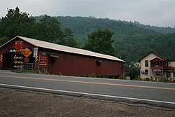
Forksville Covered Bridge, built 1850, over Loyalsock Creek with the Forksville General Store behind
Sullivan County Pennsylvania Incorporated and Unincorporated areas Forksville Highlighted.svg
Location of Forksville in Sullivan County, Pennsylvania.
USA Pennsylvania location map.svg
Red pog.svg
Forksville
Location within the U.S. state of Pennsylvania
Usa edcp location map.svg
Red pog.svg
Forksville
Forksville (the United States)
Coordinates: 41°29′32″N76°36′19″W / 41.49222°N 76.60528°W / 41.49222; -76.60528
Country United States
State Pennsylvania
County Sullivan
Settled1794
Incorporated (borough)1880
Area
[1]
  Total1.57 sq mi (4.08 km2)
  Land1.57 sq mi (4.08 km2)
  Water0.00 sq mi (0.00 km2)
Elevation
1,001 ft (305 m)
Population
 (2020) [2]
  Total111
  Density70.57/sq mi (27.24/km2)
Time zone Eastern (EST)
  Summer (DST)EDT
Zip code
18616
Area code 570
FIPS code 42-26760

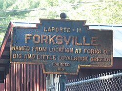
Forksville is a borough in Sullivan County, Pennsylvania, United States. The population was 110 at the 2020 census. [3] It is the home of the 150-year-old Forksville General Store, down the road from the Sullivan County Fairgrounds, and near Worlds End State Park. The name comes from the confluence of Little Loyalsock Creek and Loyalsock Creek within the borough. [4]

Contents

History

The Forksville Covered Bridge was added to the National Register of Historic Places in 1980. [5] Forksville was first permanently settled by William Molyneaux, John Warren and Powell Bird. A sawmill was built in the Forksville area in 1810. Forksville was formed from Forks Township in 1880. [4]

Geography

According to the United States Census Bureau, the borough has a total area of 1.5 square miles (3.9 km2), all land.

Demographics

Historical population
CensusPop.Note
1880 108
1890 19176.9%
1900 152−20.4%
1910 109−28.3%
1920 94−13.8%
1930 10511.7%
1940 1082.9%
1950 14534.3%
1960 131−9.7%
1970 15820.6%
1980 137−13.3%
1990 16016.8%
2000 147−8.1%
2010 145−1.4%
2020 110−24.1%
2021 (est.)111 [3] 0.9%
Sources: [6] [7] [8] [2]

At the 2010 census, [9] there were 145 people, 67 households, and 42 families residing in the borough. The population density was 96.6 people per square mile (37.3 people/km2). There were 94 housing units at an average density of 62.4 per square mile (24.1/km2). The racial makeup of the borough was 94.5% White, 2.1% Black, 2.8% Native American, and 0.6% two or more races.

Of the 67 households, 19.4% had children under the age of 18 living with them, 49.3% were married couples living together, 10.4% had a female householder with no husband present, and 37.3% were non-families. 31.3% of households were one person, and 16.4% were one person aged 65 or older. The average household size was 2.16 and the average family size was 2.60.

Forksville General Store near Worlds End State Park. Forksville General Store.jpg
Forksville General Store near Worlds End State Park.

In the borough the population was spread out, with 13.1% under the age of 18, 66.2% from 18 to 64, and 20.7% 65 or older. The median age was 45.5 years.

The median household income was $26,625 and the median family income was $31,563. Males had a median income of $26,563 versus $25,417 for females. The per capita income for the borough was $13,943. There were 19.1% of families and 22.1% of the population living below the poverty line, including 36.4% of under eighteens and none of those over 64.

Forksville Borough is protected by the Forksville Volunteer Fire Company.

Notable person

Red Grange, College and Pro Football Hall of Famer, was born in Forksville before moving to Wheaton, Illinois, at age five. Grange is widely considered to be the first superstar of the National Football League. [10]

Related Research Articles

<span class="mw-page-title-main">Sullivan County, Pennsylvania</span> County in Pennsylvania, United States

Sullivan County is a county in the Commonwealth of Pennsylvania. It is part of Northeastern Pennsylvania. As of the 2020 census, the population was 5,840, making it the second-least populous county in Pennsylvania. Its county seat is Laporte. The county was created on March 15, 1847, from part of Lycoming County and named for Major General John Sullivan.

<span class="mw-page-title-main">East Rochester, Pennsylvania</span> Borough in Pennsylvania, United States

East Rochester is a borough in central Beaver County, Pennsylvania, along the Ohio River. The population was 563 at the 2020 census. It is part of the Pittsburgh metropolitan area.

<span class="mw-page-title-main">South Fork, Pennsylvania</span> Borough in Pennsylvania, United States

South Fork is a borough in Cambria County, Pennsylvania, United States. It is part of the Johnstown, Pennsylvania Metropolitan Statistical Area. The population was 928 at the 2010 census, down from 1,138 at the 2000 census.

<span class="mw-page-title-main">Centre Hall, Pennsylvania</span> Borough in Pennsylvania, United States

Centre Hall is a borough in Centre County, Pennsylvania, United States. It is located in Penns Valley and is part of the State College, Pennsylvania Metropolitan Statistical Area. The population was 1,265 at the 2010 census, which is a 17.2% increase from the 2000 census.

<span class="mw-page-title-main">South Connellsville, Pennsylvania</span> Borough in Pennsylvania, United States

South Connellsville is a borough in Fayette County, Pennsylvania, United States. The population was 1,919 at the 2020 census, a decline from the figure of 1,970 tabulated in 2010.

<span class="mw-page-title-main">Henderson Township, Jefferson County, Pennsylvania</span> Township in Pennsylvania, United States

Henderson Township is a township in Jefferson County, Pennsylvania, United States. The population was 1,937 at the 2020 census. It was named for Jefferson County Associate Judge Joseph Henderson.

<span class="mw-page-title-main">Myerstown, Pennsylvania</span> Borough in the United States

Myerstown is a borough located in Lebanon County, Pennsylvania. It is part of the Lebanon, Pennsylvania Metropolitan statistical area. The population was 3,103 at the 2020 census. It is home to over 100 businesses, including a Bayer manufacturing plant, a GAF manufacturing plant, Farmer Boy Ag, Stoneridge Towne Centre and Wengers of Myerstown. The Evangelical Seminary is located on South College Street.

<span class="mw-page-title-main">Fairfield Township, Lycoming County, Pennsylvania</span> Township in Pennsylvania, United States

Fairfield Township is a township in Lycoming County, Pennsylvania, United States. The population was 2,833 at the 2020 census. It is part of the Williamsport Metropolitan Statistical Area.

<span class="mw-page-title-main">McNett Township, Lycoming County, Pennsylvania</span> Township in Pennsylvania, United States

McNett Township is a township in Lycoming County, Pennsylvania, United States. The population was 145 at the 2020 census, down from 174 in 2010. It is part of the Williamsport Metropolitan Statistical Area.

<span class="mw-page-title-main">Plunketts Creek Township, Lycoming County, Pennsylvania</span> Township in Pennsylvania, United States

Plunketts Creek Township is a township in Lycoming County, Pennsylvania, United States. It includes the villages of Barbours and Proctor. The population was 595 at the 2020 census, down from 684 at the 2010 census. It is part of the Williamsport Metropolitan Statistical Area.

<span class="mw-page-title-main">Upper Fairfield Township, Lycoming County, Pennsylvania</span> Township in Pennsylvania, United States

Upper Fairfield Township is a township in Lycoming County, Pennsylvania, United States. The population was 1,807 at the 2020 census. It is part of the Williamsport Metropolitan Statistical Area.

<span class="mw-page-title-main">Chapman, Pennsylvania</span> Borough in Pennsylvania, United States

Chapman is a borough in Northampton County, Pennsylvania. The population of Chapman was 223 as of the 2020 census. Chapman is part of the Lehigh Valley metropolitan area, which had a population of 861,899 and was the 68th-most populous metropolitan area in the U.S. as of the 2020 census.

<span class="mw-page-title-main">Snydertown, Northumberland County, Pennsylvania</span> Borough in Pennsylvania, United States

Snydertown is a borough in Northumberland County, Pennsylvania, United States. As of the 2010 census, the borough population was 339.

<span class="mw-page-title-main">Dushore, Pennsylvania</span> Borough in Pennsylvania, United States

Dushore is a borough in Sullivan County, Pennsylvania, United States. The population was 450 at the 2020 census. Dushore is home to Sullivan County's only traffic light.

<span class="mw-page-title-main">Eagles Mere, Pennsylvania</span> Borough in Pennsylvania, United States

Eagles Mere is a borough in Sullivan County, Pennsylvania, United States. The population was 151 at the 2020 census.

<span class="mw-page-title-main">Forks Township, Sullivan County, Pennsylvania</span> Township in Pennsylvania, United States

Forks Township is a township in Sullivan County, Pennsylvania, United States. The population was 372 at the 2020 census.

<span class="mw-page-title-main">Hillsgrove Township, Sullivan County, Pennsylvania</span> Township in Pennsylvania, United States

Hillsgrove Township is a township in Sullivan County, Pennsylvania, United States. The population was 228 at the 2020 census.

<span class="mw-page-title-main">Shrewsbury Township, Sullivan County, Pennsylvania</span> Township in Pennsylvania, United States

Shrewsbury Township is a township in Sullivan County, Pennsylvania, United States. The population was 303 at the 2020 census.

<span class="mw-page-title-main">Meshoppen, Pennsylvania</span> Borough in Pennsylvania, United States

Meshoppen is a borough that is located in Wyoming County, Pennsylvania, United States. The population was 326 at the time of the 2020 census.

<span class="mw-page-title-main">Emlenton, Pennsylvania</span> Borough in Pennsylvania, United States

Emlenton is a borough in Clarion and Venango counties in the U.S. state of Pennsylvania. The population was 625 at the 2010 census. Of these, 617 were in Venango County, and eight were in Clarion County. The borough is home to the Emlenton Bridge on I-80, which spans the Allegheny River.

References

  1. "ArcGIS REST Services Directory". United States Census Bureau. Retrieved October 12, 2022.
  2. 1 2 "Census Population API". United States Census Bureau. Retrieved Oct 12, 2022.
  3. 1 2 Bureau, US Census. "City and Town Population Totals: 2020—2021". Census.gov. US Census Bureau. Retrieved August 6, 2022.
  4. 1 2 "Forksville Borough, Sullivan County, Pennsylvania (PA)".
  5. "National Register Information System". National Register of Historic Places . National Park Service. July 9, 2010.
  6. "Census of Population and Housing". U.S. Census Bureau. Retrieved 11 December 2013.
  7. "U.S. Census website". United States Census Bureau . Retrieved 2008-01-31.
  8. "Incorporated Places and Minor Civil Divisions Datasets: Subcounty Resident Population Estimates: April 1, 2010 to July 1, 2012". Population Estimates. U.S. Census Bureau. Archived from the original on 11 June 2013. Retrieved 11 December 2013.
  9. "U.S. Census website". United States Census Bureau . Retrieved 2011-05-14.
  10. "Red Grange, Football Hero of 1920s, Dead at 87". The New York Times. 29 January 1991.