Colley Township, Sullivan County, Pennsylvania

Last updated

Colley Township, Pennsylvania
Ricketts Glen State Park Office.jpg
The park office for Ricketts Glen State Park is in Colley Township
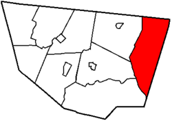
Map of Sullivan County Pennsylvania Highlighting Colley Township.png
Map of Sullivan County, Pennsylvania highlighting Colley Township
Map of Pennsylvania highlighting Sullivan County.svg
Map of Pennsylvania highlighting Sullivan County
Country United States
State Pennsylvania
County Sullivan
Settled1823
Incorporated1848
Area
[1]
  Total59.21 sq mi (153.37 km2)
  Land58.26 sq mi (150.88 km2)
  Water0.96 sq mi (2.48 km2)
Population
 (2020) [2]
  Total626 Decrease2.svg
  Estimate 
(2021) [2]
627
  Density11.67/sq mi (4.51/km2)
Time zone UTC-5 (Eastern (EST))
  Summer (DST) UTC-4 (EDT)
Area code 570
FIPS code 42-113-15208

Colley Township is a township in Sullivan County, Pennsylvania, United States. The population was 626 at the 2020 census. [2] The village of Lopez is located in the township.

Contents

History

The Clemuel Ricketts Mansion was added to the National Register of Historic Places in 1983. [3]

Geography

According to the United States Census Bureau, the township has a total area of 59.2 square miles (153 km2), of which 58.25 square miles (150.9 km2) is land and 0.95 square miles (2.5 km2) (1.63%) is water.

Colley Township is bordered by Bradford County to the north, Wyoming and Luzerne Counties to the east, Davidson Township to the southwest, and Laporte and Cherry Townships to the west.

Colley Township is home to the Clemuel Ricketts Mansion on Ganoga Lake, listed on the National Register of Historic Places, and part of Ricketts Glen State Park.

Demographics

Historical population
CensusPop.Note
2010 694
2020 626−9.8%
2021 (est.)627 [2] 0.2%
U.S. Decennial Census [4]

2010

At the 2010 census there were 694 people, 214 households, and 116 families living in the township. The population density was 11.9 people per square mile (4.65/km2). There were 640 housing units at an average density of 11/sq mi (4.3/km2). The racial makeup of the township was 76.7% White, 21.6% African American, 0.4% Native American, 1.2% Asian, and 0.1% from two or more races. Hispanic or Latino of any race were 5.8%. [5]

Of the 214 households 12.6% had children under the age of 18 living with them, 45.3% were married couples living together, 5.6% had a female householder with no husband present, and 45.8% were non-families. 40.2% of households were one person and 22.4% were one person aged 65 or older. The average household size was 1.94 and the average family size was 2.57.

The age distribution was 16.9% under the age of 18, 65.7% from 18 to 64, and 17.4% 65 or older. The median age was 25.3 years.

The median household income was $30,096 and the median family income was $35,208. Males had a median income of $23,750 versus $40,250 for females. The per capita income for the township was $14,243. About 19.5% of families and 31.5% of the population were below the poverty line, including 20.2% of those under age 18 and 30.1% of those age 65 or over.

Pajamas made in the Lopez Factories were used in the Hollywood Film, Pajama Party.

2000

At the 2000 census there were 647 people, 179 households, and 95 families living in the township. The population density was 11.2 people per square mile (4.3/km2). There were 542 housing units at an average density of 9.3/sq mi (3.6/km2). The racial makeup of the township was 70.48% White, 20.87% African American, 0.93% Native American, 0.15% Asian, 4.17% from other races, and 3.40% from two or more races. Hispanic or Latino of any race were 7.57%. [6]

Of the 179 households 14.0% had children under the age of 18 living with them, 44.1% were married couples living together, 5.0% had a female householder with no husband present, and 46.4% were non-families. 38.5% of households were one person and 23.5% were one person aged 65 or older. The average household size was 2.03 and the average family size was 2.69.

The age distribution was 28.9% under the age of 18, 26.3% from 18 to 24, 11.6% from 25 to 44, 13.8% from 45 to 64, and 19.5% 65 or older. The median age was 22 years. For every 100 females, there were 158.8 males. For every 100 females age 18 and over, there were 144.7 males.

The median household income was $23,542 and the median family income was $33,333. Males had a median income of $28,036 versus $20,417 for females. The per capita income for the township was $10,979. About 3.0% of families and 45.6% of the population were below the poverty line, including none of those under age 18 and 17.9% of those age 65 or over.

Related Research Articles

<span class="mw-page-title-main">Butte City, Idaho</span> City in Idaho, United States

Butte City is a city in Butte County, Idaho, United States. The population was 74 at the 2010 census.

<span class="mw-page-title-main">Central City, Iowa</span> City in Iowa, United States

Central City is a city in Linn County, Iowa, United States. The population was 1,264 at the 2020 census. It is part of the Cedar Rapids Metropolitan Statistical Area.

Verona Township is a township in Faribault County, Minnesota, United States. The population was 391 at the 2000 census.

<span class="mw-page-title-main">Jud, North Dakota</span> City in North Dakota, United States

Jud is a rural city in LaMoure County, North Dakota, United States. The population was 65 at the 2020 census. Jud was founded in 1904 and named for county settler Judson LaMoure. It is located along unpaved 61st Street SE, 9 miles (14 km) west of U.S. Route 281 and 25 miles (40 km) south of Interstate 94 in the midst of settled farmland and open plains.

<span class="mw-page-title-main">Logan Township, Blair County, Pennsylvania</span> Township in Pennsylvania, United States

Logan Township is a township in Blair County, Pennsylvania, United States. It is part of the Altoona, PA Metropolitan Statistical Area. It is the most populous township in Blair County, with a population of 12,413 at the 2020 census. Logan Township is home to Horseshoe Curve, a National Historic Landmark.

<span class="mw-page-title-main">Wilmot Township, Pennsylvania</span> Township in Pennsylvania, United States

Wilmot Township is a township in Bradford County, Pennsylvania. It is part of Northeastern Pennsylvania. The population was 1,204 at the 2010 census.

<span class="mw-page-title-main">Harborcreek Township, Pennsylvania</span> Township in Pennsylvania, United States

Harborcreek Township is a township in Erie County, Pennsylvania, United States. The population was 16,630 at the 2020 census, down from 17,234 at the 2010 census, up from 15,178 in 2000. It is part of the Erie Metropolitan Statistical Area.

<span class="mw-page-title-main">Menallen Township, Fayette County, Pennsylvania</span> Township in Pennsylvania, United States

Menallen Township is a township in Fayette County, Pennsylvania, United States. It is part of the Pittsburgh metropolitan area. The population was 4,095 at the 2020 census, a decline from the figure of 4,205 tabulated in 2010. The Uniontown Area School District serves the region.

<span class="mw-page-title-main">Redstone Township, Pennsylvania</span> Township in Pennsylvania, United States

Redstone Township is a township in Fayette County, Pennsylvania, United States. The population was 5,077 at the 2020 census, a decline from the figure of 5,566 tabulated in 2010. The Brownsville Area School District serves the region.

<span class="mw-page-title-main">Spring Brook Township, Pennsylvania</span> Place in Pennsylvania, United States

Spring Brook Township is a township in Lackawanna County, Pennsylvania, United States. The population was 2,753 at the 2020 census.

<span class="mw-page-title-main">Ross Township, Luzerne County, Pennsylvania</span> Township in Pennsylvania, United States

Ross Township is a township in Luzerne County, Pennsylvania, United States. The population was 2,719 at the 2020 census.

<span class="mw-page-title-main">Barry Township, Pennsylvania</span> Township in Pennsylvania, United States

Barry Township is a township in Schuylkill County, Pennsylvania. Formed in 1822, it is named for American Revolutionary War Commander John Barry and was formed from parts of Norwegian and Schuylkill Townships.

<span class="mw-page-title-main">Washington Township, Schuylkill County, Pennsylvania</span> Township in Pennsylvania, United States

Washington Township is a township that is located in Schuylkill County, Pennsylvania, United States. The population was 3,134 at the time of the 2020 census.

<span class="mw-page-title-main">Cherry Township, Sullivan County, Pennsylvania</span> Township in Pennsylvania, United States

Cherry Township is a township in Sullivan County, Pennsylvania, United States. The population was 1,475 at the 2020 census.

<span class="mw-page-title-main">Davidson Township, Sullivan County, Pennsylvania</span> Township in Pennsylvania, United States

Davidson Township is a township in Sullivan County, Pennsylvania, United States. The population was 544 at the 2020 census.

<span class="mw-page-title-main">Elkland Township, Sullivan County, Pennsylvania</span> Township in Pennsylvania, United States

Elkland Township is a township in Sullivan County, Pennsylvania, United States. The population was 547 at the 2020 census.

<span class="mw-page-title-main">Laporte Township, Sullivan County, Pennsylvania</span> Township in Pennsylvania, United States

Laporte Township is a township in Sullivan County, Pennsylvania, United States. The population was 404 at the 2020 census. Note that Laporte Township surrounds the borough of Laporte.

<span class="mw-page-title-main">Franklin Township, Susquehanna County, Pennsylvania</span> Township in Pennsylvania, United States

Franklin Township is a township in Susquehanna County, Pennsylvania, United States. The population was 833 at the 2020 census. Salt Springs State Park, a Pennsylvania state park, is in Franklin Township.

<span class="mw-page-title-main">Millersburg, Indiana</span> Town in Indiana, United States

Millersburg is a town in Clinton and Benton townships, Elkhart County, Indiana, United States. The population was 903 at the 2010 census.

<span class="mw-page-title-main">De Baca County, New Mexico</span> County in New Mexico, United States

De Baca County is a county in the U.S. state of New Mexico. As of the 2020 census, the population was 1,698, making it New Mexico's second-least populous county. Its county seat is Fort Sumner. The county is named for Ezequiel Cabeza De Baca, the second elected Governor of New Mexico.

References

  1. "2016 U.S. Gazetteer Files". United States Census Bureau. Retrieved August 14, 2017.
  2. 1 2 3 4 Bureau, US Census. "City and Town Population Totals: 2020—2021". Census.gov. US Census Bureau. Retrieved August 6, 2022.
  3. "National Register Information System". National Register of Historic Places . National Park Service. July 9, 2010.
  4. "Census of Population and Housing". Census.gov. Retrieved June 4, 2016.
  5. "U.S. Census website". United States Census Bureau . Retrieved May 14, 2011.
  6. "U.S. Census website". United States Census Bureau . Retrieved January 31, 2008.

41°31′30″N76°14′44″W / 41.52500°N 76.24556°W / 41.52500; -76.24556