National Register of Historic Places listings in Clearfield County, Pennsylvania

Last updated

Location of Clearfield County in Pennsylvania Map of Pennsylvania highlighting Clearfield County.svg
Location of Clearfield County in Pennsylvania

This is a list of the National Register of Historic Places listings in Clearfield County, Pennsylvania.

Contents

This is intended to be a complete list of the properties and districts on the National Register of Historic Places in Clearfield County, Pennsylvania, United States. The locations of National Register properties and districts for which the latitude and longitude coordinates are included below, may be seen in a map. [1]

There are 20 properties and districts listed on the National Register in the county. Another property was once listed but has been removed.


    This National Park Service list is complete through NPS recent listings posted August 5, 2022. [2]

Map all coordinates using: OpenStreetMap  
Download coordinates as: KML

Current listings

[3] Name on the RegisterImageDate listed [4] Location City or townDescription
1 Bridge in Greenwood Township
Bridge in Greenwood Township Bridge in Greenwood Township.jpg
Bridge in Greenwood Township
June 22, 1988
(#88000846)
Legislative Route 17026 over the West Branch of the Susquehanna River
40°54′39″N78°38′51″W / 40.910833°N 78.6475°W / 40.910833; -78.6475 (Bridge in Greenwood Township)
Greenwood Township Pratt through truss bridge built in 1892. Now torn down.
2 Bridge in Westover Borough
Bridge in Westover Borough Bridge in Westover Borough.jpg
Bridge in Westover Borough
June 22, 1988
(#88000736)
Legislative Route 17003/Township Route 185 over Chest Creek
40°45′09″N78°40′03″W / 40.7525°N 78.6675°W / 40.7525; -78.6675 (Bridge in Westover Borough)
Westover Open-spandrel arch bridge constructed in 1917.
3 Clearfield Armory
Clearfield Armory Clearfield Armory Apr 10.JPG
Clearfield Armory
December 22, 1989
(#89002072)
Coal Hill Road
41°00′44″N78°27′45″W / 41.012222°N 78.4625°W / 41.012222; -78.4625 (Clearfield Armory)
Lawrence Township Brick armory dating to 1938.
4 Clearfield County Courthouse
Clearfield County Courthouse Clearfield County Courthouse Jun 09.JPG
Clearfield County Courthouse
April 27, 1979
(#79002210)
2nd and Market Streets
41°01′20″N78°26′16″W / 41.022222°N 78.437778°W / 41.022222; -78.437778 (Clearfield County Courthouse)
Clearfield County courthouse building constructed in 1860.
5 Coalport Historic District
Coalport Historic District Main from Spruce in Coalport.jpg
Coalport Historic District
April 29, 1999
(#99000517)
Along Main Street, roughly from Mill to Walnut Streets
40°44′54″N78°32′07″W / 40.748333°N 78.535278°W / 40.748333; -78.535278 (Coalport Historic District)
Coalport
6 Commercial Hotel
Commercial Hotel Commercial Hotel Dubois PA 1910.jpg
Commercial Hotel
November 13, 1985
(#85003507)
Long and Brady Avenues
41°07′07″N78°45′44″W / 41.118611°N 78.762222°W / 41.118611; -78.762222 (Commercial Hotel)
DuBois Four story brick structure dating back to 1889; includes Harris-DuBois Theater.
7 Dimeling Hotel
Dimeling Hotel Dimeling Hotel Jun 09.JPG
Dimeling Hotel
April 10, 1980
(#80003474)
2nd and Market Streets
41°01′20″N78°26′19″W / 41.022222°N 78.438611°W / 41.022222; -78.438611 (Dimeling Hotel)
Clearfield Seven story former hotel constructed in 1904-1905.
8 DuBois Historic District
DuBois Historic District DuBois Historic District Aug 10.JPG
DuBois Historic District
October 24, 1997
(#97001254)
Roughly along North and South Brady Streets, and East and West Long Avenues
41°07′09″N78°45′47″W / 41.119167°N 78.763056°W / 41.119167; -78.763056 (DuBois Historic District)
Dubois
9 S.B. Elliott State Park Day Use District
S.B. Elliott State Park Day Use District S.B. Elliott State Park Pavilion 1.jpg
S.B. Elliott State Park Day Use District
February 11, 1987
(#87000023)
9 miles (14 km) north of Clearfield on Pennsylvania Route 153
41°06′47″N78°31′36″W / 41.113056°N 78.526667°W / 41.113056; -78.526667 (S.B. Elliott State Park Day Use District)
Pine Township
10 S.B. Elliott State Park Family Cabin District
S.B. Elliott State Park Family Cabin District S.B. Elliott State Park Cabin 1.jpg
S.B. Elliott State Park Family Cabin District
February 11, 1987
(#87000024)
9 miles (14 km) north of Clearfield on Pennsylvania Route 153
41°06′39″N78°31′23″W / 41.110833°N 78.523056°W / 41.110833; -78.523056 (S.B. Elliott State Park Family Cabin District)
Pine Township
11 Hogback Bridge
Hogback Bridge Hogback Bridge.jpg
Hogback Bridge
June 22, 1988
(#88000848)
Legislative Route 869 over the West Branch of the Susquehanna River
40°58′25″N78°29′26″W / 40.973611°N 78.490556°W / 40.973611; -78.490556 (Hogback Bridge)
Lawrence Township Pennsylvania (petit) truss bridge built in 1893. Modern bridge replaced the historic structure, which is now gone.
12 Irvin-Patchin House
Irvin-Patchin House Irvin-Patchin House.jpg
Irvin-Patchin House
June 19, 1979
(#79002209)
Main Street
40°48′59″N78°47′13″W / 40.816389°N 78.786944°W / 40.816389; -78.786944 (Irvin-Patchin House)
Burnside Brick dwelling constructed initially in 1850 by early settler William Irvin.
13 McGees Mills Covered Bridge
McGees Mills Covered Bridge McGees Mills Covered Bridge - Pennsylvania.jpg
McGees Mills Covered Bridge
April 17, 1980
(#80003475)
West of Mahaffey
40°52′48″N78°45′55″W / 40.88°N 78.765278°W / 40.88; -78.765278 (McGees Mills Covered Bridge)
Bell Township A 109-foot (33 m) covered bridge built in 1873.
14 Thomas Murray House
Thomas Murray House Thomas Murray House Clearfield PA Apr 10.JPG
Thomas Murray House
October 25, 1979
(#79002211)
120 S. 2nd St.
41°01′12″N78°26′17″W / 41.02°N 78.438056°W / 41.02; -78.438056 (Thomas Murray House)
Clearfield Italianate style brick dwelling constructed in 1876.
15 Old Town Historic District
Old Town Historic District Old Town Historic District Clearfield PA Apr 10.JPG
Old Town Historic District
May 15, 1979
(#79002212)
Irregular pattern along Front Street
41°01′20″N78°26′24″W / 41.022222°N 78.44°W / 41.022222; -78.44 (Old Town Historic District)
Clearfield
16 Parker Dam State Park Family Cabin District
Parker Dam State Park Family Cabin District Parker Dam State Park Family Cabin District Apr 10.JPG
Parker Dam State Park Family Cabin District
February 11, 1987
(#87000043)
5 miles (8.0 km) south of Penfield off Pennsylvania Route 153
41°11′49″N78°30′56″W / 41.196944°N 78.515556°W / 41.196944; -78.515556 (Parker Dam State Park Family Cabin District)
Huston Township
17 Parker Dam State Park-Octagonal Lodge
Parker Dam State Park-Octagonal Lodge Parker Dam State Park-Octagonal Lodge Apr 10.JPG
Parker Dam State Park-Octagonal Lodge
May 11, 1987
(#87000044)
5 miles (8.0 km) south of Penfield off Pennsylvania Route 153
41°12′32″N78°30′11″W / 41.208889°N 78.503056°W / 41.208889; -78.503056 (Parker Dam State Park-Octagonal Lodge)
Huston Township
18 Parker Dam State Park-Parker Dam District
Parker Dam State Park-Parker Dam District Parker Dam State Park-Parker Dam District Apr 10.JPG
Parker Dam State Park-Parker Dam District
February 11, 1987
(#87000049)
5 miles (8.0 km) south of Penfield off Pennsylvania Route 153
41°11′54″N78°30′29″W / 41.198333°N 78.508056°W / 41.198333; -78.508056 (Parker Dam State Park-Parker Dam District)
Huston Township
19 Joseph F. and Anna B. Schrot Farm
Joseph F. and Anna B. Schrot Farm Joseph F. and Anna B. Schrot Farmhouse.jpg
Joseph F. and Anna B. Schrot Farm
September 8, 2011
(#11000643)
880 Carbon Mine Road
40°58′57″N78°29′15″W / 40.982500°N 78.487500°W / 40.982500; -78.487500 (Joseph F. and Anna B. Schrot Farm)
Lawrence Township
20 St. Severin's Old Log Church
St. Severin's Old Log Church St. Severin's Old Log Church Apr 10.JPG
St. Severin's Old Log Church
June 5, 1975
(#75001633)
West of Cooper Settlement off Pennsylvania Route 53
41°01′54″N78°06′38″W / 41.031667°N 78.110556°W / 41.031667; -78.110556 (St. Severin's Old Log Church)
Cooper Township Roman Catholic church built by German settlers in about 1851.

Former listing

[3] Name on the RegisterImageDate listedDate removedLocationCity or townDescription
1 DuBois Mansion
DuBois Mansion DuBois Mansion DuBois PA.jpg
DuBois Mansion
April 16, 1975
(#75001634)
January 21, 1983College Pl.
DuBois The DuBois Mansion existed from 1875-1978. The originally Italianate building was remodeled to Tudor in 1902 as shown in this image. After 1934 it became part of the Penn State Campus. A frozen and burst water pipe damaged the building heavily and in 1978 - despite appeals and fundraising - the building was demolished. Currently the site of DuBois campus of Penn State University and the DuBois Area High School.

See also

Related Research Articles

National Register of Historic Places listings in Berks County, Pennsylvania

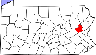
This is a list of the National Register of Historic Places listings in Berks County, Pennsylvania.

National Register of Historic Places listings in Pittsburgh, Pennsylvania

The following properties are listed on the National Register of Historic Places in Pittsburgh, Pennsylvania.

National Register of Historic Places listings in Bedford County, Pennsylvania

This is a list of the National Register of Historic Places listings in Bedford County, Pennsylvania.

National Register of Historic Places listings in Butler County, Pennsylvania

This is a list of the National Register of Historic Places listings in Butler County, Pennsylvania.

National Register of Historic Places listings in Carbon County, Pennsylvania

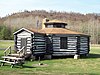
This is a list of the National Register of Historic Places listings in Carbon County, Pennsylvania.

National Register of Historic Places listings in Crawford County, Pennsylvania

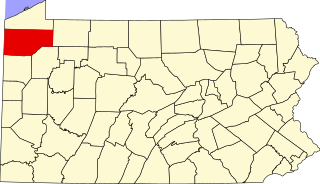
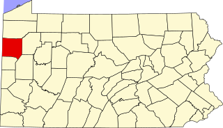
This is a list of the National Register of Historic Places listings in Crawford County, Pennsylvania.

National Register of Historic Places listings in Cumberland County, Pennsylvania

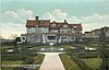
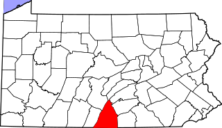
This is a list of the National Register of Historic Places listings in Cumberland County, Pennsylvania.

National Register of Historic Places listings in Clinton County, Pennsylvania

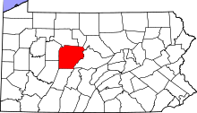
This is a list of the National Register of Historic Places listings in Clinton County, Pennsylvania.

National Register of Historic Places listings in Franklin County, Pennsylvania

This is a list of the National Register of Historic Places listings in Franklin County, Pennsylvania.

National Register of Historic Places listings in Jefferson County, Pennsylvania

This is a list of the National Register of Historic Places listings in Jefferson County, Pennsylvania.

National Register of Historic Places listings in Juniata County, Pennsylvania

This is a list of the National Register of Historic Places listings in Juniata County, Pennsylvania.

National Register of Historic Places listings in Lehigh County, Pennsylvania

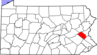
This is a list of the National Register of Historic Places listings in Lehigh County, Pennsylvania.

National Register of Historic Places listings in Luzerne County, Pennsylvania

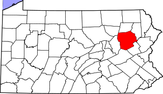
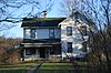
This is a list of the National Register of Historic Places listings in Luzerne County, Pennsylvania.

National Register of Historic Places listings in Mercer County, Pennsylvania

This is a list of the National Register of Historic Places listings in Mercer County, Pennsylvania.

National Register of Historic Places listings in Mifflin County, Pennsylvania

This is a list of the National Register of Historic Places listings in Mifflin County, Pennsylvania.

National Register of Historic Places listings in Pike County, Pennsylvania

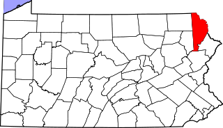
This is a list of the National Register of Historic Places listings in Pike County, Pennsylvania.

National Register of Historic Places listings in Perry County, Pennsylvania

This is a list of the National Register of Historic Places listings in Perry County, Pennsylvania.

National Register of Historic Places listings in Snyder County, Pennsylvania

This is a list of the National Register of Historic Places listings in Snyder County, Pennsylvania.

National Register of Historic Places listings in Warren County, Pennsylvania

This is a list of the National Register of Historic Places listings in Warren County, Pennsylvania.

National Register of Historic Places listings in Wayne County, Pennsylvania

This is a list of the National Register of Historic Places listings in Wayne County, Pennsylvania.

References

  1. The latitude and longitude information provided in this table was derived originally from the National Register Information System, which has been found to be fairly accurate for about 99% of listings. Some locations in this table may have been corrected to current GPS standards.
  2. National Park Service, United States Department of the Interior, "National Register of Historic Places: Weekly List Actions", retrieved August 5, 2022.
  3. 1 2 Numbers represent an alphabetical ordering by significant words. Various colorings, defined here, differentiate National Historic Landmarks and historic districts from other NRHP buildings, structures, sites or objects.
  4. The eight-digit number below each date is the number assigned to each location in the National Register Information System database, which can be viewed by clicking the number.