National Register of Historic Places listings in Tioga County, Pennsylvania

Last updated
Location of Tioga County in Pennsylvania Map of Pennsylvania highlighting Tioga County.svg
Location of Tioga County in Pennsylvania

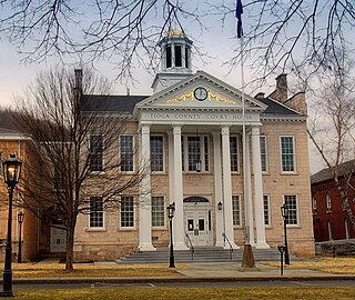
This is a list of the National Register of Historic Places listings in Tioga County, Pennsylvania.

Contents

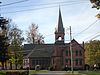
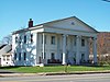
This is intended to be a complete list of the properties and districts on the National Register of Historic Places in Tioga County, Pennsylvania, United States. The locations of National Register properties and districts for which the latitude and longitude coordinates are included below, may be seen in a map. [1]

National Register of Historic Places federal list of historic sites in the United States

The National Register of Historic Places (NRHP) is the United States federal government's official list of districts, sites, buildings, structures, and objects deemed worthy of preservation for their historical significance. A property listed in the National Register, or located within a National Register Historic District, may qualify for tax incentives derived from the total value of expenses incurred preserving the property.

Tioga County, Pennsylvania County in the United States

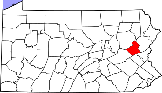
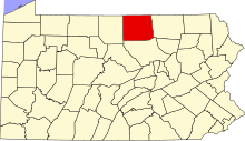
Tioga County is a county located on the central northern border of the U.S. state of Pennsylvania. As of the 2010 census, the population was 41,981. Its county seat is Wellsboro. The county was created on March 26, 1804, from part of Lycoming County and later organized in 1812. It is named for the Tioga River.

Pennsylvania State of the United States of America

Pennsylvania, officially the Commonwealth of Pennsylvania, is a state located in the northeastern, Great Lakes and Mid-Atlantic regions of the United States. The Appalachian Mountains run through its middle. The Commonwealth is bordered by Delaware to the southeast, Maryland to the south, West Virginia to the southwest, Ohio to the west, Lake Erie and the Canadian province of Ontario to the northwest, New York to the north, and New Jersey to the east.

There are 10 properties and districts listed on the National Register in the county.

This National Park Service list is complete through NPS recent listings posted May 11, 2018. [2]
Map all coordinates using: OpenStreetMap  ·  Google Maps
Download coordinates as: KML  ·  GPX

Current listings

[3] Name on the Register Image Date listed [4] Location City or town Description
1 Blackwell Methodist Episcopal Church
Blackwell Methodist Episcopal Church Blackwell Church as it is in 2012.jpg
Blackwell Methodist Episcopal Church
September 18, 2013
(#13000746)
117 Blackwell Square
41°33′26″N77°22′48″W / 41.557283°N 77.380117°W / 41.557283; -77.380117 (Blackwell Methodist Episcopal Church)
Morris Township
2 Colton Point State Park
Colton Point State Park Colton Point State Park overlook 1.jpg
Colton Point State Park
February 12, 1987
(#87000112)
5 miles (8.0 km) south of U.S. Route 6 at Ansonia
41°42′13″N77°27′51″W / 41.703611°N 77.464167°W / 41.703611; -77.464167 (Colton Point State Park)
Shippen Township
3 James Ford House
James Ford House James Ford House Oct 09.JPG
James Ford House
December 6, 1975
(#75001667)
Cowanesque Street
41°59′46″N77°07′44″W / 41.996111°N 77.128889°W / 41.996111; -77.128889 (James Ford House)
Lawrenceville
4 Mansfield Armory
Mansfield Armory Mansfield Armory Oct 09.JPG
Mansfield Armory
May 9, 1991
(#91000515)
Smythe Park
41°48′23″N77°04′46″W / 41.806389°N 77.079444°W / 41.806389; -77.079444 (Mansfield Armory)
Mansfield
5 Parkhurst Memorial Presbyterian Church
Parkhurst Memorial Presbyterian Church Parkhurst Presbyterian, Elkland Pennsylvania.jpg
Parkhurst Memorial Presbyterian Church
April 16, 2012
(#12000224)
302 W. Main St.
41°59′14″N77°19′01″W / 41.98712°N 77.317082°W / 41.98712; -77.317082 (Parkhurst Memorial Presbyterian Church)
Elkland
6 Robinson House
Robinson House Robinson House Wellsboro PA Oct 09.JPG
Robinson House
August 3, 1977
(#77001196)
120 Main Street
41°44′48″N77°18′14″W / 41.746667°N 77.303889°W / 41.746667; -77.303889 (Robinson House)
Wellsboro
7 Jesse Robinson House
Jesse Robinson House Jesse Robinson House Wellsboro PA Oct 09.JPG
Jesse Robinson House
February 21, 1991
(#91000089)
141 Main Street
41°44′42″N77°18′16″W / 41.745°N 77.304444°W / 41.745; -77.304444 (Jesse Robinson House)
Wellsboro
8 Judge John Ryon House
Judge John Ryon House Judge John Ryon House Oct 09.JPG
Judge John Ryon House
December 16, 1977
(#77001195)
Main Street
41°59′41″N77°07′35″W / 41.994722°N 77.126389°W / 41.994722; -77.126389 (Judge John Ryon House)
Lawrenceville
9 Wellsboro Armory
Wellsboro Armory Wellsboro Armory Oct 09.JPG
Wellsboro Armory
May 9, 1991
(#91000521)
2 Central Avenue
41°44′51″N77°18′11″W / 41.7475°N 77.303056°W / 41.7475; -77.303056 (Wellsboro Armory)
Wellsboro
10 Wellsboro Historic District
Wellsboro Historic District Tioga County Courthouse Official.jpg
Wellsboro Historic District
January 5, 2005
(#04001458)
Roughly bounded by Nichols, Tioga, Charleston, Jackson Streets, East Avenue, Bacon Street, Morris Lane, Sturrock, Meade, Grant, Walnut, Academy Streets, West Avenue, West Water and Highland Streets
41°44′57″N77°18′05″W / 41.749167°N 77.301389°W / 41.749167; -77.301389 (Wellsboro Historic District)
Wellsboro

See also

Related Research Articles

National Register of Historic Places listings in Tioga County, New York Wikimedia list article

List of the National Register of Historic Places listings in Tioga County, New York

National Register of Historic Places listings in Delaware County, Pennsylvania Wikimedia list article

This is a list of the National Register of Historic Places listings in Delaware County, Pennsylvania.

National Register of Historic Places listings in York County, Pennsylvania Wikimedia list article

This is a list of the National Register of Historic Places listings in York County, Pennsylvania.

National Register of Historic Places listings in Lycoming County, Pennsylvania Wikimedia list article

This is a list of the National Register of Historic Places listings in Lycoming County, Pennsylvania.

National Register of Historic Places listings in Dauphin County, Pennsylvania Wikimedia list article

This is a list of the National Register of Historic Places listings in Dauphin County, Pennsylvania.

National Register of Historic Places listings in Pittsburgh, Pennsylvania Wikimedia list article

This is a list of the National Register of Historic Places listings in Pittsburgh, Pennsylvania.

National Register of Historic Places listings in Armstrong County, Pennsylvania Wikimedia list article

This is a list of the National Register of Historic Places listings in Armstrong County, Pennsylvania.

National Register of Historic Places listings in Bedford County, Pennsylvania Wikimedia list article

This is a list of the National Register of Historic Places listings in Bedford County, Pennsylvania.

National Register of Historic Places listings in Bradford County, Pennsylvania Wikimedia list article

This is a list of the National Register of Historic Places listings in Bradford County, Pennsylvania.

National Register of Historic Places listings in Carbon County, Pennsylvania Wikimedia list article

This is a list of the National Register of Historic Places listings in Carbon County, Pennsylvania.

National Register of Historic Places listings in Centre County, Pennsylvania Wikimedia list article

This is a list of the National Register of Historic Places listings in Centre County, Pennsylvania.

National Register of Historic Places listings in Crawford County, Pennsylvania Wikimedia list article

This is a list of the National Register of Historic Places listings in Crawford County, Pennsylvania.

National Register of Historic Places listings in Monroe County, Pennsylvania Wikimedia list article

This is a list of the National Register of Historic Places listings in Monroe County, Pennsylvania.

National Register of Historic Places listings in Potter County, Pennsylvania Wikimedia list article

This is a list of the National Register of Historic Places listings in Potter County, Pennsylvania.

National Register of Historic Places listings in Sullivan County, Pennsylvania Wikimedia list article

This is a list of the National Register of Historic Places listings in Sullivan County, Pennsylvania.

National Register of Historic Places listings in Wyoming County, Pennsylvania Wikimedia list article

This is a list of the National Register of Historic Places listings in Wyoming County, Pennsylvania.

National Register of Historic Places listings in Union County, Pennsylvania Wikimedia list article

This is a list of the National Register of Historic Places listings in Union County, Pennsylvania.

National Register of Historic Places listings in Westmoreland County, Pennsylvania Wikimedia list article

This is a list of the National Register of Historic Places listings in Westmoreland County, Pennsylvania.

National Register of Historic Places listings in northern Chester County, Pennsylvania Wikimedia list article

This is a list of the National Register of Historic Places listings in northern Chester County, Pennsylvania.

National Register of Historic Places listings in southern Chester County, Pennsylvania Wikimedia list article

This is a list of the National Register of Historic Places listings in southern Chester County, Pennsylvania.

References

  1. The latitude and longitude information provided in this table was derived originally from the National Register Information System, which has been found to be fairly accurate for about 99% of listings. For about 1% of NRIS original coordinates, experience has shown that one or both coordinates are typos or otherwise extremely far off; some corrections may have been made. A more subtle problem causes many locations to be off by up to 150 yards, depending on location in the country: most NRIS coordinates were derived from tracing out latitude and longitudes off of USGS topographical quadrant maps created under the North American Datum of 1927 , which differs from the current, highly accurate WGS84 GPS system used by most on-line maps. Chicago is about right, but NRIS longitudes in Washington are higher by about 4.5 seconds, and are lower by about 2.0 seconds in Maine. Latitudes differ by about 1.0 second in Florida. Some locations in this table may have been corrected to current GPS standards.
  2. "National Register of Historic Places: Weekly List Actions". National Park Service, United States Department of the Interior. Retrieved on May 11, 2018.
  3. Numbers represent an ordering by significant words. Various colorings, defined here, differentiate National Historic Landmarks and historic districts from other NRHP buildings, structures, sites or objects.
  4. The eight-digit number below each date is the number assigned to each location in the National Register Information System database, which can be viewed by clicking the number.