Antrim, Pennsylvania | |
|---|---|
 Church in Antrim with apartment for rent | |
 Antrim, Pennsylvania | |
| Coordinates: 41°38′02″N77°17′13″W / 41.63389°N 77.28694°W | |
| Country | United States |
| State | Pennsylvania |
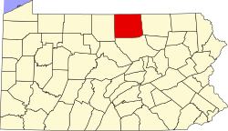
| County | Tioga |
| Elevation | 1,654 ft (504 m) |
| Time zone | UTC-5 (Eastern (EST)) |
| • Summer (DST) | UTC-4 (EDT) |
| ZIP | 16901 |
| Area code | 570 |
| GNIS feature ID | 1168343 [1] |
Antrim is an unincorporated community in Duncan Township, Tioga County, in the U.S. state of Pennsylvania. [1] It lies slightly east of Pennsylvania Route 287 between Williamsport and Wellsboro. [2]