Arnot, Pennsylvania | |
|---|---|
 Post office | |
 Arnot, Pennsylvania  Arnot, Pennsylvania | |
| Coordinates: 41°39′47″N77°06′52″W / 41.66306°N 77.11444°W | |
| Country | United States |
| State | Pennsylvania |
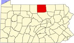
| County | Tioga |
| Township | Bloss |
| Area | |
• Total | 1.04 sq mi (2.69 km2) |
| • Land | 1.03 sq mi (2.66 km2) |
| • Water | 0.012 sq mi (0.03 km2) |
| Elevation | 1,676 ft (511 m) |
| Population | |
• Total | 315 |
| • Density | 306.9/sq mi (118.49/km2) |
| Time zone | UTC-5 (Eastern (EST)) |
| • Summer (DST) | UTC-4 (EDT) |
| ZIP code | 16912 [4] |
| Area codes | 272 and 570 |
| FIPS code | 42-03104 |
| GNIS feature ID | 2634204 |
Arnot is a census-designated place [5] located in Bloss Township, Tioga County in the state of Pennsylvania, United States. It is located off US Route 15 near the borough of Blossburg. As of the 2020 census, Arnot had a population of 315. [6]