National Register of Historic Places listings in Crawford County, Pennsylvania

Last updated

Location of Crawford County in Pennsylvania Map of Pennsylvania highlighting Crawford County.svg
Location of Crawford County in Pennsylvania

This is a list of the National Register of Historic Places listings in Crawford County, Pennsylvania.

Contents

This is intended to be a complete list of the properties and districts on the National Register of Historic Places in Crawford County, Pennsylvania, United States. The locations of National Register properties and districts for which the latitude and longitude coordinates are included below, may be seen in a map. [1]

There are 19 properties and districts listed on the National Register in the county.


    This National Park Service list is complete through NPS recent listings posted December 8, 2023. [2]

Map all coordinates using: OpenStreetMap

Current listings

[3] Name on the RegisterImageDate listed [4] Location City or townDescription
1 Baldwin-Reynolds House
Baldwin-Reynolds House Historic American Buildings Survey, William J. Bulger, Photographer, 1937 EXTERIOR (FRONT ELEVATION). - Reynolds House, 639 Terrace Street, Meadville, Crawford County, PA HABS PA,20-MEDVI,3-1.tif
Baldwin-Reynolds House
December 30, 1974
(#74001777)
Terrace Street
41°38′52″N80°09′07″W / 41.647778°N 80.151944°W / 41.647778; -80.151944 (Baldwin-Reynolds House)
Meadville
2 Bentley Hall
Bentley Hall Bentley Hall.jpg
Bentley Hall
May 6, 1977
(#77001156)
Allegheny College campus
41°38′55″N80°08′51″W / 41.648611°N 80.1475°W / 41.648611; -80.1475 (Bentley Hall)
Meadville
3 Bridge in East Fallowfield Township
Bridge in East Fallowfield Township Bridge in East Fallowfield Township site.jpg
Bridge in East Fallowfield Township
June 22, 1988
(#88000825)
Legislative Route 20012 over Unger Run
41°32′06″N80°20′12″W / 41.535000°N 80.336667°W / 41.535000; -80.336667 (Bridge in East Fallowfield Township)
East Fallowfield Township Replaced
4 Bridge in Oil Creek Township
Bridge in Oil Creek Township Bridge in Oil Creek Township, road closed sign.jpg
Bridge in Oil Creek Township
June 22, 1988
(#88000833)
State Route 2020 over Oil Creek
41°37′45″N79°42′10″W / 41.629167°N 79.702778°W / 41.629167; -79.702778 (Bridge in Oil Creek Township)
Oil Creek Township Removed from site. [5]
5 Bridge in Rockdale Township
Bridge in Rockdale Township Bridge in Rockdale Township site.jpg
Bridge in Rockdale Township
June 22, 1988
(#88000829)
Legislative Route 20076 over French Creek
41°48′38″N79°59′02″W / 41.810417°N 79.983889°W / 41.810417; -79.983889 (Bridge in Rockdale Township)
Rockdale Township Replaced
6 Bridge in West Mead Township
Bridge in West Mead Township Bridge in West Mead Township site.jpg
Bridge in West Mead Township
June 22, 1988
(#88000827)
Legislative Route 20027 over French Creek
41°35′21″N80°09′02″W / 41.589167°N 80.150556°W / 41.589167; -80.150556 (Bridge in West Mead Township)
West Mead Township Replaced
7 John Brown Tannery Site
John Brown Tannery Site John Brown Tannery foundation.jpg
John Brown Tannery Site
December 14, 1978
(#78002383)
500 feet south of the junction of Pennsylvania Route 77 and John Brown Road [6]
41°43′09″N79°57′04″W / 41.719167°N 79.951111°W / 41.719167; -79.951111 (John Brown Tannery Site)
Richmond Township Only the foundation remains after a fire in 1907
8 Cambridge Springs Bridge
Cambridge Springs Bridge Cambridge Springs Bridge site.jpg
Cambridge Springs Bridge
June 22, 1988
(#88000824)
Legislative Route 84 spur B over French Creek
41°48′23″N80°03′41″W / 41.806389°N 80.061389°W / 41.806389; -80.061389 (Cambridge Springs Bridge)
Cambridge Springs Replaced
9 Independent Congregational Church
Independent Congregational Church Independent Congregational Church Meadville PA 1936.jpg
Independent Congregational Church
March 8, 1978
(#78002381)
346 Chestnut Street
41°38′14″N80°09′01″W / 41.637222°N 80.150278°W / 41.637222; -80.150278 (Independent Congregational Church)
Meadville
10 Amos Kelly House
Amos Kelly House Amos Kelly House Full View May 2010.jpg
Amos Kelly House
July 23, 1980
(#80003477)
325 South Main Street
41°48′06″N80°03′32″W / 41.801667°N 80.058889°W / 41.801667; -80.058889 (Amos Kelly House)
Cambridge Springs
11 Meadville Downtown Historic District
Meadville Downtown Historic District Crawford County Pennsylvania Courthouse.jpg
Meadville Downtown Historic District
October 2, 1984
(#84000023)
Roughly bounded by Chancery Lane, Mulberry, Walnut and Chestnut Streets
41°38′20″N80°09′04″W / 41.638889°N 80.151111°W / 41.638889; -80.151111 (Meadville Downtown Historic District)
Meadville
12 Dr. J.R. Mosier Office
Dr. J.R. Mosier Office Dr. J.R. Mosier Office.jpg
Dr. J.R. Mosier Office
June 13, 1976
(#77001157)
Terrace Street
41°38′47″N80°09′08″W / 41.646389°N 80.152222°W / 41.646389; -80.152222 (Dr. J.R. Mosier Office)
Meadville
13 Riverside Hotel
Riverside Hotel Riverside Inn, Cambridge Springs, PA 2.jpg
Riverside Hotel
December 13, 1978
(#78002380)
1 Fountain Street
41°48′21″N80°03′12″W / 41.80575°N 80.053333°W / 41.80575; -80.053333 (Riverside Hotel)
Cambridge Springs Destroyed by fire, May 2nd, 2017
14 Roueche House
Roueche House Roueche House in Meadville.jpg
Roueche House
March 4, 1982
(#82003784)
762 Park Avenue
41°38′33″N80°09′04″W / 41.642500°N 80.151111°W / 41.642500; -80.151111 (Roueche House)
Meadville
15 Ruter Hall
Ruter Hall Ruter Hall, Allegheny College.jpg
Ruter Hall
September 18, 1978
(#78002382)
North Main Street on Allegheny College campus
41°38′54″N80°08′46″W / 41.648333°N 80.146111°W / 41.648333; -80.146111 (Ruter Hall)
Meadville
16 Edward Saeger House
Edward Saeger House Edward Saeger House May 2010.jpg
Edward Saeger House
August 22, 1980
(#80003479)
375 Main Street
41°43′07″N80°08′53″W / 41.718611°N 80.148056°W / 41.718611; -80.148056 (Edward Saeger House)
Saegertown
17 Judge Henry Shippen House
Judge Henry Shippen House Judge Henry Shippen House.jpg
Judge Henry Shippen House
June 6, 1984
(#84003339)
403 Chestnut Street
41°38′14″N80°08′52″W / 41.637222°N 80.147778°W / 41.637222; -80.147778 (Judge Henry Shippen House)
Meadville
18 Titusville City Hall
Titusville City Hall Titusville City Hall.jpg
Titusville City Hall
March 31, 1975
(#75001635)
107 North Franklin Street
41°37′39″N79°40′25″W / 41.627417°N 79.673694°W / 41.627417; -79.673694 (Titusville City Hall)
Titusville
19 Titusville Historic District
Titusville Historic District Titusville, Pennsylvania (8483328693).jpg
Titusville Historic District
January 31, 1985
(#85000178)
Roughly bounded by Petroleum, Spruce, Franklin, Perry, Monroe, Main and Spring Streets
41°37′47″N79°40′26″W / 41.629722°N 79.673889°W / 41.629722; -79.673889 (Titusville Historic District)
Titusville

Former listings

[3] Name on the RegisterImageDate listedDate removedLocationCity or townDescription
1 Shadeland May 6, 1983
(#83002230)
August 7, 1992North of Springboro on Pennsylvania Route 18
Springboro Burned down by owners on June 28, 1992.
2 Dr. James White House July 24, 1980
(#80003478)
July 21, 2004Junction of U.S. Route 322 and Pennsylvania Route 285
Hartstown

See also

Related Research Articles

<span class="mw-page-title-main">National Register of Historic Places listings in Berks County, Pennsylvania</span>

This is a list of the National Register of Historic Places listings in Berks County, Pennsylvania.

<span class="mw-page-title-main">National Register of Historic Places listings in Fayette County, Pennsylvania</span>

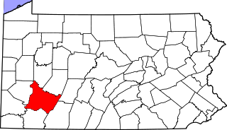
This is a list of the National Register of Historic Places listings in Fayette County, Pennsylvania.

<span class="mw-page-title-main">National Register of Historic Places listings in York County, Pennsylvania</span>

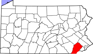
This is a list of the National Register of Historic Places listings in York County, Pennsylvania.

<span class="mw-page-title-main">National Register of Historic Places listings in Lycoming County, Pennsylvania</span>

This is a list of the National Register of Historic Places listings in Lycoming County, Pennsylvania.

<span class="mw-page-title-main">National Register of Historic Places listings in Dauphin County, Pennsylvania</span>

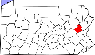
This is a list of the National Register of Historic Places listings in Dauphin County, Pennsylvania.

<span class="mw-page-title-main">National Register of Historic Places listings in Bedford County, Pennsylvania</span>

This is a list of the National Register of Historic Places listings in Bedford County, Pennsylvania.

<span class="mw-page-title-main">National Register of Historic Places listings in Butler County, Pennsylvania</span>

This is a list of the National Register of Historic Places listings in Butler County, Pennsylvania.

<span class="mw-page-title-main">National Register of Historic Places listings in Cambria County, Pennsylvania</span>

This is a list of the National Register of Historic Places listings in Cambria County, Pennsylvania.

<span class="mw-page-title-main">National Register of Historic Places listings in Carbon County, Pennsylvania</span>

This is a list of the National Register of Historic Places listings in Carbon County, Pennsylvania.

<span class="mw-page-title-main">National Register of Historic Places listings in Centre County, Pennsylvania</span>

This is a list of the National Register of Historic Places listings in Centre County, Pennsylvania.

<span class="mw-page-title-main">National Register of Historic Places listings in Cumberland County, Pennsylvania</span>

This is a list of the National Register of Historic Places listings in Cumberland County, Pennsylvania.

<span class="mw-page-title-main">National Register of Historic Places listings in Clinton County, Pennsylvania</span>

This is a list of the National Register of Historic Places listings in Clinton County, Pennsylvania.

<span class="mw-page-title-main">National Register of Historic Places listings in Indiana County, Pennsylvania</span>

This is a list of the National Register of Historic Places listings in Indiana County, Pennsylvania.

<span class="mw-page-title-main">National Register of Historic Places listings in Juniata County, Pennsylvania</span>

This is a list of the National Register of Historic Places listings in Juniata County, Pennsylvania.

<span class="mw-page-title-main">National Register of Historic Places listings in Lebanon County, Pennsylvania</span>

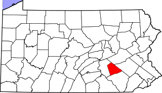
This is a list of the National Register of Historic Places listings in Lebanon County, Pennsylvania.

<span class="mw-page-title-main">National Register of Historic Places listings in Snyder County, Pennsylvania</span>

This is a list of the National Register of Historic Places listings in Snyder County, Pennsylvania.

<span class="mw-page-title-main">National Register of Historic Places listings in Venango County, Pennsylvania</span>

This is a list of the National Register of Historic Places listings in Venango County, Pennsylvania.

<span class="mw-page-title-main">National Register of Historic Places listings in Westmoreland County, Pennsylvania</span>

This is a list of the National Register of Historic Places listings in Westmoreland County, Pennsylvania.

<span class="mw-page-title-main">National Register of Historic Places listings in northern Chester County, Pennsylvania</span>

This is a list of the National Register of Historic Places listings in northern Chester County, Pennsylvania.

<span class="mw-page-title-main">National Register of Historic Places listings in southern Chester County, Pennsylvania</span>

This is a list of the National Register of Historic Places listings in southern Chester County, Pennsylvania.

References

  1. The latitude and longitude information provided in this table was derived originally from the National Register Information System, which has been found to be fairly accurate for about 99% of listings. Some locations in this table may have been corrected to current GPS standards.
  2. National Park Service, United States Department of the Interior, "National Register of Historic Places: Weekly List Actions", retrieved December 8, 2023.
  3. 1 2 Numbers represent an alphabetical ordering by significant words. Various colorings, defined here, differentiate National Historic Landmarks and historic districts from other NRHP buildings, structures, sites or objects.
  4. The eight-digit number below each date is the number assigned to each location in the National Register Information System database, which can be viewed by clicking the number.
  5. Pennsylvania Bulletin , Doc. No. 98-1762.
  6. Location derived from its NRHP nomination form; the NRIS lists the site as "Address Restricted"