Lincolnville, Pennsylvania | |
---|---|
Coordinates: 41°47′33″N79°50′17″W / 41.79250°N 79.83806°W | |
Country | United States |
State | Pennsylvania |
County | Crawford County |
Township | Bloomfield |
Area | |
• Total | 0.27 sq mi (0.70 km2) |
• Land | 0.27 sq mi (0.70 km2) |
• Water | 0.00 sq mi (0.00 km2) |
Elevation | 1,379 ft (420 m) |
Population | |
• Total | 86 |
• Density | 320.90/sq mi (123.68/km2) |
Time zone | UTC-4 (EST) |
• Summer (DST) | UTC-5 (EDT) |
Area code | 814 |
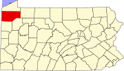
Lincolnville is a census-designated place in Crawford County, Pennsylvania, United States. The population was 96, as per the 2010 census. [3]
Lincolnville is located in northeastern Crawford County at 41°47′33″N79°50′17″W / 41.79250°N 79.83806°W (41.792597, -79.838101), [4] in south-central Bloomfield Township. It is on the south side of Oil Creek, 1 mile (1.6 km) south of the source of the creek at the outlet of Canadohta Lake.
According to the United States Census Bureau, the Lincolnville CDP has a total area of 0.3 square miles (0.7 km2), all land. [3]
Census | Pop. | Note | %± |
---|---|---|---|
2020 | 86 | — | |
U.S. Decennial Census [5] |
As of the census [6] of 2000, there were 112 people, 38 households, and 31 families residing in the CDP. The population density was 381.4 inhabitants per square mile (147.3/km2). There were 40 housing units at an average density of 136.2 per square mile (52.6/km2). The racial makeup of the CDP was 100.00% White.
There were 38 households, out of which 36.8% had children under the age of 18 living with them, 68.4% were married couples living together, 10.5% had a female householder with no husband present, and 15.8% were non-families. 10.5% of all households were made up of individuals, and 7.9% had someone living alone who was 65 years of age or older. The average household size was 2.95 and the average family size was 3.13.
In the CDP, the population was spread out, with 26.8% under the age of 18, 10.7% from 18 to 24, 27.7% from 25 to 44, 20.5% from 45 to 64, and 14.3% who were 65 years of age or older. The median age was 34 years. For every 100 females, there were 115.4 males. For every 100 females age 18 and over, there were 82.2 males.
The median income for a household in the CDP was $30,714, and the median income for a family was $27,292. Males had a median income of $30,833 versus $21,250 for females. The per capita income for the CDP was $10,659. There were 22.9% of families and 36.5% of the population living below the poverty line, including 51.7% of under eighteens and none of those over 64.
Taylorsville is a census-designated place (CDP) in Plumas County, California, United States. The population was 150 at the 2010 census, down from 154 at the 2000 census. The annual Stone Ranch Reunion is held in Taylorsville.
Granville South is a census-designated place (CDP) in Licking County, Ohio, United States. The population was 1,420 at the 2020 census.
Adamsville is a census-designated place (CDP) in Crawford County, Pennsylvania, United States. The population was 67 at the 2010 census, down from 117 in 2000.
Atlantic is a census-designated place (CDP) in Crawford County, Pennsylvania, United States. The population was 77 at the 2010 census, up from 43 in 2000.
Bloomfield Township is a township in Crawford County, Pennsylvania, United States. The population was 1,861 at the 2020 census.
Canadohta Lake is a census-designated place (CDP) in Crawford County, Pennsylvania, United States. The population was 503 at the 2020 census.
Conneaut Lakeshore is a census-designated place (CDP) in Crawford County, Pennsylvania, United States. The population was 2,395 at the 2010 census.
Fredericksburg is a census-designated place (CDP) in Crawford County, Pennsylvania, United States. The population was 733 at the 2010 census, down from 1,140 in 2000, when the CDP included the area that is now listed as Kerrtown.
Geneva is a census-designated place in Crawford County, Pennsylvania, United States. The population was 109 at the 2010 census.
Guys Mills is a census-designated place in Crawford County, Pennsylvania, United States. The population was 124 at the 2010 census.
Hartstown is a census-designated place (CDP) in Crawford County, Pennsylvania, United States. The population was 201 at the 2010 census, down from 246 in 2000.
Pymatuning Central is a census-designated place (CDP) in Crawford County, Pennsylvania, United States. The population was 2,269 at the 2010 census.
Pymatuning North is a census-designated place (CDP) in Crawford County, Pennsylvania, United States. The population was 311 at the 2010 census.
Pymatuning South is a census-designated place (CDP) in Crawford County, Pennsylvania, United States. The population was 479 at the 2010 census.
Riceville is a census-designated place in Crawford County, Pennsylvania, United States. The population was 68 at the 2010 census.
Seneca is a census-designated place (CDP) in Venango County, Pennsylvania, United States. As of the 2000 census, the CDP population was 966.
Woodland Heights is a census-designated place (CDP) in Venango County, Pennsylvania, United States. The population was 1,402 at the 2000 census.
Warren South is a former census-designated place (CDP) in Warren County, Pennsylvania, United States. The population was 1,651 at the 2000 census.
Bruni is a census-designated place (CDP) in Webb County, Texas, United States. The population was 379 at the 2010 census.
Camden is a census-designated place (CDP) comprising the main village in the town of Camden in Knox County, Maine, United States. The population was 3,570 at the 2010 census, out of 4,850 in the entire town of Camden.