Conneautville, Pennsylvania

Last updated
Conneautville, Pennsylvania
Conneautville, Pennsylvania (4826616560).jpg
Valley Church
Etymology: Conneautee, Seneca word
Crawford County Pennsylvania Incorporated and Unincorporated areas Conneautville Highlighted.svg
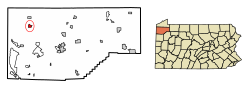
Location of Conneautville in Crawford County, Pennsylvania.
USA Pennsylvania location map.svg
Red pog.svg
Conneautville
Location of Conneautville in Pennsylvania
Coordinates: 41°45′29″N80°22′10″W / 41.75806°N 80.36944°W / 41.75806; -80.36944
CountryUnited States
State Pennsylvania
County Crawford
Founded1843
Government
  MayorAllen W. Clark (R)
Area
[1]
  Total1.12 sq mi (2.90 km2)
  Land1.11 sq mi (2.88 km2)
  Water0.01 sq mi (0.01 km2)
Elevation
[2] (middle of borough)
949 ft (289 m)
Highest elevation
[2] (east side of borough)
1,100 ft (300 m)
Lowest elevation
[2] (Conneaut Creek)
920 ft (280 m)
Population
 (2020) [3]
  Total736
  Estimate 
(2022) [4]
729
  Density663.97/sq mi (256.47/km2)
Time zone UTC-4 (EST)
  Summer (DST) UTC-5 (EDT)
ZIP code
16406 [5]
Area code 814

Conneautville is a borough in Crawford County, Pennsylvania, United States, situated along Conneaut Creek. The population was 736 at the 2020 census, [4] down from 774 at the 2010 census. [6]

Contents

History

Conneautville was founded in 1814 by Alexander Power, a surveyor and engineer. Conneautville was first called "Powerstown" or made reference to as "Power's Tract". Power wanted it called "Conneautville" after the Seneca name Conneaut or Conneautee, meaning "Snow Place" according to one interpretation.[ citation needed ]

West Jefferson Street, Conneautvile, PA in a postcard sent on August 27, 1923 Aug 27 1923 Conneautville PA.jpg
West Jefferson Street, Conneautvile, PA in a postcard sent on August 27, 1923

Geography

Conneautville is in northwestern Crawford County at 41°45′29″N80°22′10″W / 41.75806°N 80.36944°W / 41.75806; -80.36944 (41.758019, -80.369470), [7] in the valley of Conneaut Creek, which flows north and west to Lake Erie. The borough is bordered by Spring Township to the north and Summerhill Township to the south.

Pennsylvania Route 18 passes through the center of the borough, leading north 10 miles (16 km) to Albion and south 11 miles (18 km) to Conneaut Lake. Pennsylvania Route 198 leads west from Conneautville 8 miles (13 km) to the Ohio border and east 9 miles (14 km) to Interstate 79 near Saegertown.

According to the United States Census Bureau, Conneautville has a total area of 1.0 square mile (2.7 km2), of which 0.004 square miles (0.01 km2), or 0.55%, is water. [6]

Demographics

Historical population
CensusPop.Note
1850 787
1860 96422.5%
1870 1,0003.7%
1880 941−5.9%
1890 757−19.6%
1900 92021.5%
1910 867−5.8%
1920 96911.8%
1930 927−4.3%
1940 9654.1%
1950 1,17722.0%
1960 1,100−6.5%
1970 1,032−6.2%
1980 971−5.9%
1990 822−15.3%
2000 8483.2%
2010 774−8.7%
2020 736−4.9%
2022 (est.)729 [4] −1.0%
Sources: [8] [9] [10] [11] [12] [3]

At the census [9] of 2000, there were 848 people, 352 households and 229 families in the borough. The population density was 778.7 inhabitants per square mile (300.7/km2). There were 377 housing units at an average of 346.2 per square mile (133.5/km2). The racial makeup was 98.47% White, 0.24% African American, 0.24% Native American, 0.12% Asian, 0.12% from other races, and 0.83% from two or more races. Hispanic or Latino of any race were 0.59% of the population.

There were 352 households, of which 30.1% had children under 18 with them, 52.0% were married couples living together, 8.2% had a female householder with no husband present, and 34.7% were non-families. 30.7% of all households were made up of individuals, and 17.3% had someone living alone 65 or older. The average household size was 2.41 and the average family size 3.03.

In the borough 24.6% were under 18, 6.6% from 18 to 24, 28.7% from 25 to 44, 22.4% from 45 to 64, and 17.7% 65 or older. The median was 40. For every 100 females there were 88.9 males. For every 100 females age 18 and over, there were 85.8 males.

The median household income was $35,083, and the median family income was $40,833. Males had a median income of $30,481 versus $19,583 for females. The per capita income for the borough was $17,087. 4.1% of families and 7.4% of the population were below the poverty line, including 10.0% of those under 18 and 11.9% of those 65 or over.

Notable person

Related Research Articles

<span class="mw-page-title-main">Beaver Township, Crawford County, Pennsylvania</span> Township in Pennsylvania, United States

Beaver Township is a township in Crawford County, Pennsylvania, United States. The population was 795 at the 2020 census.

<span class="mw-page-title-main">Cochranton, Pennsylvania</span> Borough in Pennsylvania, United States

Cochranton is a borough in Crawford County, Pennsylvania, United States. The population was 1,124 at the 2020 census, down from 1,136 as of the 2010 census.

<span class="mw-page-title-main">Conneaut Township, Crawford County, Pennsylvania</span> Township in Pennsylvania, United States

Conneaut Township is a township in Crawford County, Pennsylvania, United States. The population was 1,334 at the 2020 census.

<span class="mw-page-title-main">Conneaut Lake, Pennsylvania</span> Borough in Pennsylvania, United States

Conneaut Lake is a borough in Crawford County, Pennsylvania, located at the southern end of the lake of the same name. The population was 625 at the 2020 census, down from 653 at the 2010 census.

<span class="mw-page-title-main">Conneaut Lakeshore, Pennsylvania</span> Census-designated place in Pennsylvania, United States

Conneaut Lakeshore is a census-designated place (CDP) in Crawford County, Pennsylvania, United States. The population was 2,395 at the 2010 census.

<span class="mw-page-title-main">East Fallowfield Township, Crawford County, Pennsylvania</span> Township in Pennsylvania, United States

East Fallowfield Township is a township in Crawford County, Pennsylvania, United States. The population was 1,516 at the 2020 census, down from 1,620 in 2010.

<span class="mw-page-title-main">Fairfield Township, Crawford County, Pennsylvania</span> Township in Pennsylvania, United States

Fairfield Township is a township in Crawford County, Pennsylvania, United States. The population was 1,011 at the 2020 census, down from the 2010 census.

<span class="mw-page-title-main">Greenwood Township, Crawford County, Pennsylvania</span> Township in Pennsylvania, United States

Greenwood Township is a township in Crawford County, Pennsylvania, United States. The population was 1,424 at the 2020 census, down from 1,454 at the 2010 census.

<span class="mw-page-title-main">Harmonsburg, Pennsylvania</span> Census-designated place in Pennsylvania, United States

Harmonsburg is a census-designated place (CDP) in Crawford County, Pennsylvania, United States. The population was 401 at the 2010 census, up from 356 in 2000.

<span class="mw-page-title-main">Hayfield Township, Crawford County, Pennsylvania</span> Township in Pennsylvania, United States

Hayfield Township is a township in Crawford County, Pennsylvania, United States. The population was 2,776 at the 2020 census, down from 2,940 at the 2010 census.

<span class="mw-page-title-main">Linesville, Pennsylvania</span> Borough in Pennsylvania, United States

Linesville is a borough in Crawford County, Pennsylvania, United States. The population was 961 at the 2020 census, down from 987 at the 2019 census. The town derives its name from its founders, who included William Line, who migrated from Carlisle, Pennsylvania, circa the early 1820s, and his relative, Amos Line, who was the town's surveyor and main proprietor. Amos Line "penetrated the western Pennsylvania wilderness as a member of the Pennsylvania Population Company in the early 1800s."

<span class="mw-page-title-main">Pine Township, Crawford County, Pennsylvania</span> Township in Pennsylvania, United States

Pine Township is a township in Crawford County, Pennsylvania, United States. The population was 432 at the 2020 census, down from 462 at the 2010 census.

<span class="mw-page-title-main">Sadsbury Township, Crawford County, Pennsylvania</span> Township in Pennsylvania, United States

Sadsbury Township is a township in Crawford County, Pennsylvania, United States. The population was 2,752 at the 2020 census, down from 2,933 at the 2010 census.

<span class="mw-page-title-main">Spring Township, Crawford County, Pennsylvania</span> Township in Pennsylvania, United States

Spring Township is a township in Crawford County, Pennsylvania, United States. The population was 1,407 at the 2020 census, down from 1,548 at the 2010 census.

<span class="mw-page-title-main">Springboro, Pennsylvania</span> Borough in Pennsylvania, United States

Springboro is a borough in Crawford County, Pennsylvania, United States, located 35 miles southwest of Erie. The population was 376 at the 2020 census, down from 477 at the 2010 census.

<span class="mw-page-title-main">Summerhill Township, Crawford County, Pennsylvania</span> Township in Pennsylvania, United States

Summerhill Township is a township in Crawford County, Pennsylvania, United States. The population was 1,197 at the 2020 census, down from 1,236 at the 2010 census.

<span class="mw-page-title-main">Summit Township, Crawford County, Pennsylvania</span> Township in Pennsylvania, United States

Summit Township is a township in Crawford County, Pennsylvania, United States. The population was 1,902 at the 2020 census, down from 2,027 at the 2010 census.

<span class="mw-page-title-main">Conneaut Township, Erie County, Pennsylvania</span> Township in Pennsylvania, United States

Conneaut Township is a township in Erie County, Pennsylvania, United States. The population was 4,188 at the 2020 census, down from 4,290 at the 2010 census, up from 3,908 in 2000.

<span class="mw-page-title-main">Cranesville, Pennsylvania</span> Borough in Pennsylvania, United States

Cranesville is a borough in Erie County, Pennsylvania, United States. The population was 572 at the 2020 census. It is part of the Erie Metropolitan Statistical Area.

<span class="mw-page-title-main">Springfield Township, York County, Pennsylvania</span> Township in Pennsylvania, United States

Springfield Township is a township in York County, Pennsylvania, United States. The population was 6,023 at the 2020 census.

References

  1. "ArcGIS REST Services Directory". United States Census Bureau. Retrieved October 12, 2022.
  2. 1 2 3 "Conneautville Topo Map, Crawford County PA (Conneautville Area)". TopoZone. Locality, LLC. Retrieved 2 September 2019.
  3. 1 2 "Census Population API". United States Census Bureau. Retrieved Oct 12, 2022.
  4. 1 2 3 Bureau, US Census. "City and Town Population Totals: 2020-2022". Census.gov. US Census Bureau. Retrieved August 24, 2023.
  5. "Conneautville PA ZIP Code". zipdatamaps.com. 2023. Retrieved October 31, 2023.
  6. 1 2 "Geographic Identifiers: 2010 Census Summary File 1 (G001): Conneautville borough, Pennsylvania". U.S. Census Bureau, American Factfinder. Archived from the original on February 13, 2020. Retrieved June 3, 2015.
  7. "US Gazetteer files: 2010, 2000, and 1990". United States Census Bureau. 2011-02-12. Retrieved 2011-04-23.
  8. "Census of Population and Housing". U.S. Census Bureau. Retrieved 11 December 2013.
  9. 1 2 "U.S. Census website". United States Census Bureau . Retrieved 2008-01-31.
  10. "Incorporated Places and Minor Civil Divisions Datasets: Subcounty Resident Population Estimates: April 1, 2010 to July 1, 2012". Population Estimates. U.S. Census Bureau. Archived from the original on 11 June 2013. Retrieved 11 December 2013.
  11. Bureau, U. S. Census. "U.S. Census website". United States Census Bureau . US Census Brueau. Retrieved 17 July 2019.
  12. "Census of Population and Housing". Census.gov. Retrieved June 4, 2016.
  13. "Power, Effie Louise - The Encyclopedia of Cleveland History". www.ech.case.edu. Western Reserve University and Western Reserve Historical Society. Retrieved 9 January 2016.