Burnside, Pennsylvania

Last updated
Burnside, Pennsylvania
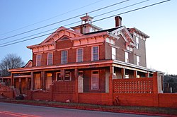
Irvin-Patchin House.jpg
Clearfield County Pennsylvania Incorporated and Unincorporated areas Burnside Highlighted.svg
Location of Burnside in Clearfield County, Pennsylvania.
Map of Pennsylvania highlighting Clearfield County.svg
Map showing Clearfield County in Pennsylvania
USA Pennsylvania location map.svg
Red pog.svg
Burnside
Pennsylvania
Coordinates: 40°48′48″N78°47′31″W / 40.81333°N 78.79194°W / 40.81333; -78.79194
Country United States
State Pennsylvania
County Clearfield
Incorporated1874
Government
  TypeBorough Council
Area
[1]
  Total1.73 sq mi (4.49 km2)
  Land1.68 sq mi (4.35 km2)
  Water0.06 sq mi (0.14 km2)
Elevation
[2]
1,312 ft (400 m)
Population
 (2020) [3]
  Total188
  Density111.90/sq mi (43.20/km2)
Time zone UTC-5 (Eastern (EST))
  Summer (DST) UTC-4 (EDT)
ZIP code
15721
Area code 814
FIPS code 42-10280
GNIS feature ID 1215094 [2]

Burnside is a borough that is located in Clearfield County, Pennsylvania, United States. The population was 188 at thetime of the 2020 census. [4]

Contents

Geography

Burnside is located in southwestern Clearfield County along the West Branch Susquehanna River. It is bordered on the north, east, and south by Burnside Township and on the west by Indiana County.

U.S. Route 219 passes through the borough, leading north 37 miles (60 km) to DuBois and south 26 miles (42 km) to Ebensburg.

According to the United States Census Bureau, Burnside has a total area of 1.73 square miles (4.49 km2), of which 1.68 square miles (4.35 km2) is land and 0.054 square miles (0.14 km2), or 3.16%, is water. [5]

Demographics

Historical population
CensusPop.Note
1880 279
1890 2924.7%
1900 647121.6%
1910 493−23.8%
1920 480−2.6%
1930 350−27.1%
1940 41418.3%
1950 400−3.4%
1960 307−23.2%
1970 3162.9%
1980 3479.8%
1990 3500.9%
2000 283−19.1%
2010 234−17.3%
2020 188−19.7%
2021 (est.)189 [4] 0.5%
Sources: [6] [7] [8] [9] [3]

As of the census [7] of 2000, there were 283 people, 102 households, and seventy-nine families residing in the borough.

The population density was 168.8 inhabitants per square mile (65.2/km2). There were 115 housing units at an average density of 68.6 per square mile (26.5/km2).

The racial makeup of the borough was 100.00% White.

There were 102 households, out of which 35.3% had children who were under the age of eighteen living with them, 61.8% were married couples living together, 11.8% had a female householder with no husband present, and 21.6% were non-families. 17.6% of all households were made up of individuals, and 7.8% had someone living alone who was sixty-five years of age or older.

The average household size was 2.77 and the average family size was 3.10.

Within the borough, the population was spread out, with 25.1% of residents who were under the age of eighteen, 8.8% from who were aged eighteen to twenty-four, 27.9% who were aged twenty-five to forty-four, 25.8% who were aged forty-five to sixty-four, and 12.4% who were sixty-five years of age or older. The median age was thirty-seven years.

For every one hundred females, there were 106.6 males. For every one hundred females who were aged eighteen or older, there were 100.0 males.

The median income for a household in the borough was $21,818, and the median income for a family was $22,031. Males had a median income of $25,833 compared with that of $12,250 for females.

The per capita income for the borough was $9,993.

Approximately 22.2% of families and 27.2% of the population were living below the poverty line, including 48.5% of those who were under the age of eighteen and 4.4% of those who were sixty-five or older.

Related Research Articles

<span class="mw-page-title-main">Glenfield, Pennsylvania</span> Borough in Pennsylvania, United States

Glenfield is a borough in Allegheny County, Pennsylvania, United States, situated along the Ohio River. The population was two hundred and twelve at the time of the 2020 census.

<span class="mw-page-title-main">Ashville, Pennsylvania</span> Borough in Pennsylvania, United States

Ashville is a borough in Cambria County, Pennsylvania, United States. It is part of the Johnstown, Pennsylvania Metropolitan Statistical Area. However, it is much closer to Altoona and is often considered a suburb of the latter. The population was 213 at the 2020 census.

<span class="mw-page-title-main">White Township, Cambria County, Pennsylvania</span> Township in Pennsylvania, United States

White Township is a township that is located in Cambria County, Pennsylvania, United States. The population was 836 at the time of the 2010 census.

<span class="mw-page-title-main">Burnside Township, Centre County, Pennsylvania</span> Township in Pennsylvania, United States

Burnside Township is a township in Centre County, Pennsylvania, United States. It is part of the State College, Pennsylvania, Metropolitan Statistical Area. It is located approximately at 41°08′03″N77°09′58″W.

<span class="mw-page-title-main">Pine Glen, Pennsylvania</span> Census-designated place in Pennsylvania, United States

Pine Glen is an unincorporated community and census-designated place (CDP) in Centre County, Pennsylvania, United States. It is part of the State College, Pennsylvania Metropolitan Statistical Area. It is part of Burnside Township. The population was 190 at the 2010 census.

<span class="mw-page-title-main">Burnside Township, Clearfield County, Pennsylvania</span> Township in Pennsylvania, United States

Burnside Township is a township in Clearfield County, Pennsylvania, United States. The population was 1,064 at the time of the 2020 census.

<span class="mw-page-title-main">Graham Township, Clearfield County, Pennsylvania</span> Township in Pennsylvania, United States

Graham Township is a township in Clearfield County, Pennsylvania, United States. The population was 1,329 at the time of the 2020 census.

<span class="mw-page-title-main">Huston Township, Clearfield County, Pennsylvania</span> Township in Pennsylvania, United States

Huston Township is an American township which is located in Clearfield County, Pennsylvania. The population was 1,264 at the time of the 2020 census.

<span class="mw-page-title-main">Jordan Township, Clearfield County, Pennsylvania</span> Township in Pennsylvania, United States

Jordan Township is a township in Clearfield County, Pennsylvania, United States. The population was 476 at the time of the 2020 census.

<span class="mw-page-title-main">Knox Township, Clearfield County, Pennsylvania</span> Township in Pennsylvania, United States

Knox Township is a township that is located in Clearfield County, Pennsylvania, United States. As of the 2020 United States Census, the population was 599.

<span class="mw-page-title-main">Pike Township, Clearfield County, Pennsylvania</span> Township in Pennsylvania, United States

Pike Township is a township that is located in Clearfield County, Pennsylvania, United States. The population was 2,308 at the time of the 2020 census.

<span class="mw-page-title-main">Pine Township, Clearfield County, Pennsylvania</span> Township in Pennsylvania, United States

Pine Township is a township that is located in Clearfield County, Pennsylvania, United States. The population was fifty-nine at the time of the 2020 census.

<span class="mw-page-title-main">Troutville, Pennsylvania</span> Borough in Pennsylvania, United States

Troutville is a borough in Clearfield County, Pennsylvania, United States. The population was 230 at the 2020 census.

<span class="mw-page-title-main">Worthville, Pennsylvania</span> Borough in Pennsylvania, United States

Worthville is a borough in Jefferson County, Pennsylvania, United States. The population was sixty-seven at the time of the 2010 census, a decline from the figure of eighty-five, which had been tabulated in 2000.

<span class="mw-page-title-main">Landingville, Pennsylvania</span> Borough in Pennsylvania, United States

Landingville is a borough in Schuylkill County, Pennsylvania, United States. The population was 137 at the time of the 2020 census.

<span class="mw-page-title-main">Ringtown, Pennsylvania</span> Borough in Pennsylvania, United States

Ringtown is a borough that is located in Schuylkill County, Pennsylvania, United States. It is approximately five miles north to northwest of Shenandoah and seventeen miles west to southwest of Hazleton.

<span class="mw-page-title-main">Wellersburg, Pennsylvania</span> Borough in Pennsylvania, United States

Wellersburg is a borough that is located in Somerset County, Pennsylvania, United States. It is part of the Johnstown, Pennsylvania, Metropolitan Statistical Area.

<span class="mw-page-title-main">Prompton, Pennsylvania</span> Borough in Pennsylvania, United States

Prompton is a borough that is located in Wayne County, Pennsylvania, United States. The population was 250 at the time of the 2010 census.

<span class="mw-page-title-main">Adamsburg, Pennsylvania</span> Borough in Pennsylvania, United States

Adamsburg is a borough that is located in Westmoreland County, Pennsylvania, United States. The population was 144 at the time of the 2020 federal census.

<span class="mw-page-title-main">Yoe, Pennsylvania</span> Borough in Pennsylvania, United States

Yoe is a borough in York County, Pennsylvania, United States. The population was 1,058 at the time of the 2020 census. It is part of the York–Hanover metropolitan area.

References

  1. "ArcGIS REST Services Directory". United States Census Bureau. Retrieved October 12, 2022.
  2. 1 2 U.S. Geological Survey Geographic Names Information System: Burnside, Pennsylvania
  3. 1 2 "Census Population API". United States Census Bureau. Retrieved Oct 12, 2022.
  4. 1 2 Bureau, US Census. "City and Town Population Totals: 2020—2021". Census.gov. US Census Bureau. Retrieved August 7, 2022.
  5. "Geographic Identifiers: 2010 Census Summary File 1 (G001): Burnside borough, Pennsylvania". U.S. Census Bureau, American Factfinder. Archived from the original on April 30, 2015. Retrieved April 30, 2015.
  6. "Census of Population and Housing". U.S. Census Bureau. Retrieved 11 December 2013.
  7. 1 2 "U.S. Census website". United States Census Bureau . Retrieved 2008-01-31.
  8. "Incorporated Places and Minor Civil Divisions Datasets: Subcounty Resident Population Estimates: April 1, 2010 to July 1, 2012". Population Estimates. U.S. Census Bureau. Archived from the original on 11 June 2013. Retrieved 11 December 2013.
  9. "Census of Population and Housing". Census.gov. Retrieved June 4, 2016.