
Janesville is an unincorporated community in Clearfield County, Pennsylvania, United States. The community is located at the intersection of Pennsylvania Route 253, Pennsylvania Route 453, and Pennsylvania Route 729, 2.9 miles (4.7 km) south-southwest of Ramey. Janesville has a post office with ZIP code 16680, which opened on February 25, 1826.

La Madera is a census-designated place in Rio Arriba County, New Mexico, United States. Its population was 154 as of the 2010 census. La Madera has a post office with ZIP code 87539. New Mexico State Road 111 and New Mexico State Road 519 intersect in the community.
West Salisbury is an unincorporated community in Somerset County, Pennsylvania, United States. The community is located along Pennsylvania Route 669 on the western border of Salisbury. West Salisbury had a post office from March 10, 1900, until July 23, 2011; it still has its own ZIP code, 15565.
Uledi is an unincorporated community in Fayette County, Pennsylvania, United States. The community is located along Pennsylvania Route 21 4 miles (6.4 km) west of Uniontown. Uledi has a post office with ZIP code 15484, which opened on April 14, 1902.
Alverton is an unincorporated community in Westmoreland County, Pennsylvania, United States. The community is located along Pennsylvania Route 981 2.5 miles (4.0 km) west of Mount Pleasant. Alverton has a post office with ZIP code 15612.
Ardara is an unincorporated community in Westmoreland County, Pennsylvania, United States. The community is located along Pennsylvania Route 993 2.9 miles (4.7 km) northwest of Irwin. Ardara has a post office with ZIP code 15615, which opened on May 6, 1907.
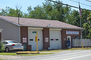
Jones Mills is an unincorporated community in Westmoreland County, Pennsylvania, United States. The community is located along Pennsylvania Routes 31 and 381 2.8 miles (4.5 km) east-southeast of Donegal. Jones Mills has a post office with ZIP code 15646, which opened on May 23, 1850.
Spring Church is an unincorporated community in Armstrong County, Pennsylvania, United States. The community is located along Pennsylvania Route 56 4.4 miles (7.1 km) east-northeast of Apollo. Spring Church has a post office with ZIP code 15686.
Branchton is an unincorporated community in Butler County, Pennsylvania, United States. The community is located near Pennsylvania Route 8 3.7 miles (6.0 km) east of Slippery Rock. Branchton had a post office until April 23, 2005; it still has its own ZIP code, 16021.
Imler is an unincorporated community in Bedford County, Pennsylvania, United States. The community is 13 miles (21 km) north of Bedford. Imler has a post office with ZIP code 16655.
Morann is an unincorporated community in Clearfield County, Pennsylvania, United States. The community is located along Pennsylvania Route 153 2.8 miles (4.5 km) south-southwest of Houtzdale. Morann has a post office with ZIP code 16663, which opened on June 19, 1890.
New Enterprise is an unincorporated community in Bedford County, Pennsylvania, United States. The community is located along Pennsylvania Route 869 11.6 miles (18.7 km) north-northeast of Bedford. New Enterprise has a post office with ZIP code 16664.
Saint Boniface is an unincorporated community in Cambria County, Pennsylvania, United States. The community is located along Pennsylvania Route 36 1.7 miles (2.7 km) east of Hastings. Saint Boniface has a post office with ZIP code 16675.
Smoke Run is an unincorporated community in Clearfield County, Pennsylvania, United States. The community is located along Pennsylvania Route 453 1.6 miles (2.6 km) west of Ramey. Smoke Run has a post office with ZIP code 16681.
Wood is an unincorporated community in the U.S. state of Pennsylvania; portions of the community lie in Bedford, Fulton, and Hundington counties. The community is 2.4 miles (3.9 km) south of Broad Top City. Wood has a post office with ZIP code 16694, which opened on September 9, 1908.
Crosby is an unincorporated community in McKean County, Pennsylvania, United States. The community is located along Pennsylvania Route 46 5.4 miles (8.7 km) south-southeast of Smethport. Crosby has a post office with ZIP code 16724.
Derrick City is an unincorporated community in McKean County, Pennsylvania, United States. The community is located at the intersection of Pennsylvania Route 346 and Pennsylvania Route 646 4.1 miles (6.6 km) east-northeast of Bradford. Derrick City has a post office with ZIP code 16727.
Russell City is an unincorporated community in Elk County, Pennsylvania, United States. The community is located along Pennsylvania Route 66 and Pennsylvania Route 948 14 miles (23 km) northwest of Ridgway. Russell City had a post office until April 23, 2005; it still has its own ZIP code, 16728.
East Smethport is an unincorporated community in McKean County, Pennsylvania, United States. The community is located at the intersection of U.S. Route 6 and Pennsylvania Route 46 near the eastern border of Smethport. East Smethport has a post office with ZIP code 16730.
Rixford is an unincorporated community in McKean County, Pennsylvania, United States. The community is located along Pennsylvania Route 246 8.3 miles (13.4 km) east-southeast of Bradford. Rixford has a post office with ZIP code 16745.


