A potter's field, paupers' grave or common grave is a place for the burial of unknown, unclaimed or indigent people. "Potter's field" is of Biblical origin, referring to Akeldama, stated to have been purchased after Judas Iscariot's suicide by the chief priests of Jerusalem with the coins that had been paid to Judas for his identification of Jesus. The priests are stated to have acquired it for the burial of strangers, criminals, and the poor, the coins paid to Judas being considered blood money. Prior to Akeldama's use as a burial ground, it had been a site where potters collected high-quality, deeply red clay for the production of ceramics, thus the name potters' field.

Christ Church Burial Ground in Philadelphia is an important early-American cemetery. It is the final resting place of Benjamin Franklin and his wife, Deborah. Four other signers of the Declaration of Independence are buried here, Benjamin Rush, Francis Hopkinson, Joseph Hewes, and George Ross. Two additional signers of the Declaration of Independence, James Wilson and Robert Morris, are buried at Christ Church just a few blocks away.

The Granary Burying Ground in Massachusetts is the city of Boston's third-oldest cemetery, founded in 1660 and located on Tremont Street. It is the burial location of Revolutionary War-era patriots, including Paul Revere, the five victims of the Boston Massacre, and three signers of the Declaration of Independence: Samuel Adams, John Hancock, and Robert Treat Paine. The cemetery has 2,345 grave-markers, but historians estimate that as many as 5,000 people are buried in it. The cemetery is adjacent to Park Street Church, behind the Boston Athenæum and immediately across from Suffolk University Law School. It is a site on Boston's Freedom Trail. The cemetery's Egyptian revival gate and fence were designed by architect Isaiah Rogers (1800–1869), who designed an identical gate for Newport's Touro Cemetery.

Fox Chase is a neighborhood in Northeast Philadelphia, Pennsylvania, United States.

African Burial Ground National Monument is a monument at Duane Street and African Burial Ground Way in the Civic Center section of Lower Manhattan, New York City. Its main building is the Ted Weiss Federal Building at 290 Broadway. The site contains the remains of more than 419 Africans buried during the late 17th and 18th centuries in a portion of what was the largest colonial-era cemetery for people of African descent, some free, most enslaved. Historians estimate there may have been as many as 10,000–20,000 burials in what was called the Negroes Burial Ground in the 18th century. The five to six acre site's excavation and study was called "the most important historic urban archaeological project in the United States." The Burial Ground site is New York's earliest known African-American cemetery; studies show an estimated 15,000 African American people were buried here.

Point Breeze is a multicultural neighborhood in South Philadelphia in Philadelphia, Pennsylvania, United States. It is bounded by 25th Street to the west, Washington Avenue to the north, Broad Street to the east, and Moore Street to the south. Southwest Center City lies to its north. Passyunk Square and East Passyunk Crossing lie to its east. Point Breeze is separated from Grays Ferry to the west by a CSX railway viaduct over 25th Street.

Mikveh Israel Cemetery is the oldest Jewish cemetery in Philadelphia, Pennsylvania, giving evidence of a settled community as early as 1740. A number of outstanding patriots, pioneers, and other notables of the Jewish faith who made important contributions to the history and freedom of America during the Colonial and Revolutionary period were interred here, and for this reason, in 1959, by an act of Congress, the burial ground was designated as a unit of the Independence National Historical Park, while continuing to be maintained by the sponsoring Congregation Mikveh Israel. The cemetery was certified by the Philadelphia Historical Commission, and in 1971, it was listed on the National Register of Historic Places.

Franklin Square is one of the five original open-space parks planned by William Penn when he laid out the city of Philadelphia, Pennsylvania, in 1682. It is located in the Center City area, between North 6th and 7th streets, and between Race Street and the Vine Street Expressway (I-676).

Mount Moriah Cemetery is a historic rural cemetery that spans the border between Southwest Philadelphia and Yeadon, Pennsylvania. It was established in 1855 and is the largest cemetery in Pennsylvania. It is 200 acres in size and contains 150,000 burials. It differed from Philadelphia's other rural cemeteries such as Laurel Hill Cemetery and the Woodlands Cemetery in that it was easily accessible by streetcar; allowed burials of African-Americans, Jews and Muslims; and catered to a more middle-class clientele.

Eden Cemetery is a historic African-American cemetery located in Collingdale, Pennsylvania. It was established June 20, 1902, and is the oldest existing black owned cemetery in the United States. The cemetery covers about 53 acres and contains approximately 93,000 burials.

Mount Zion Cemetery/Female Union Band Society Cemetery is a historic cemetery located at 27th Street NW and Mill Road NW in the Georgetown neighborhood of Washington, D.C., in the United States. The cemetery is actually two adjoining burial grounds: the Mount Zion Cemetery and Female Union Band Society Cemetery. Together these cemeteries occupy approximately three and a half acres of land. The property fronts Mill Road NW and overlooks Rock Creek Park to the rear. Mount Zion Cemetery, positioned to the East, is approximately 67,300 square feet in area; the Female Union Band Cemetery, situated to the West, contains approximately 66,500 square feet. Mount Zion Cemetery, founded in 1808 as The Old Methodist Burial Ground, was leased property later sold to Mount Zion United Methodist Church. Although the cemetery buried both White and Black persons since its inception, it served an almost exclusively African American population after 1849. In 1842, the Female Union Band Society purchased the western lot to establish a secular burying ground for African Americans. Both cemeteries were abandoned by 1950.
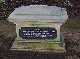
A cholera pit was a burial place used in a time of emergency when the disease was prevalent. Such mass graves were often unmarked and were placed in remote or specially selected locations. Public fears of contagion, lack of space within existing churchyards and restrictions placed on the movements of people from location to location also contributed to their establishment and use. Many of the victims were poor and lacked the funds for memorial stones, however memorials were sometimes added at a later date.

The Presbyterian Burying Ground, also known as the Old Presbyterian Burying Ground, was a historic cemetery which existed between 1802 and 1909 in the Georgetown neighborhood of Washington, D.C., in the United States. It was one of the most prominent cemeteries in the city until the 1860s. Burials there tapered significantly after Oak Hill Cemetery was founded nearby in 1848. The Presbyterian Burying Ground closed to new burials in 1887, and about 500 to 700 bodies were disinterred after 1891 when an attempt was made to demolish the cemetery and use the land for housing. The remaining graves fell into extensive disrepair. After a decade of effort, the District of Columbia purchased the cemetery in 1909 and built Volta Park there, leaving nearly 2,000 bodies buried at the site. Occasional human remains and tombstones have been discovered at the park since its construction. A number of figures important in the early history of Georgetown and Washington, D.C., military figures, politicians, merchants, and others were buried at Presbyterian Burying Ground.

St. Paul's Church is an Episcopal church founded in 1702 in Chester, Pennsylvania. The church is a part of the Episcopal Diocese of Pennsylvania. It is located at 301 East 9th Street and is an active worship center.
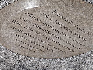
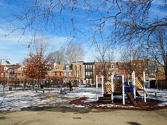
Old Town of Flushing Burial Ground is a historic cemetery located in Flushing, Queens, New York City. It was established in 1840 and known as The Olde Towne of Flushing Burial Ground. It was the result of Cholera and Smallpox epidemics in 1840 and 1844, added by town elders north of Flushing Cemetery due to fears of contamination of church burial grounds. Once known as "Pauper Burial Ground", "Colored Cemetery of Flushing" and "Martins Field", it was purchased by the New York City Department of Parks and Recreation on December 2, 1914, and renamed in 2009 to "The Olde Towne of Flushing Burial Ground".

Lafayette Cemetery was a cemetery in the Passyunk Square neighborhood of Philadelphia, Pennsylvania. It was established in 1828 and originally intended for 14,000 burials but over time fell into disrepair and became overcrowded with 47,000 burials. In 1946, the cemetery was condemned by the city of Philadelphia. The bodies were disinterred in 1947, transported to the Evergreen Memorial Park in Bensalem, Pennsylvania, and reinterred in a mass grave.

Cathedral Cemetery, also known as Old Cathedral Cemetery, is a historic Catholic cemetery established by the Roman Catholic Archdiocese of Philadelphia in 1849 in the Mills Creek neighborhood of Philadelphia, Pennsylvania, United States. It was the first of 12 diocesan cemeteries established in the Philadelphia area.