Callowhill, Philadelphia

Last updated
Callowhill
Callowhill, Philadelphia.jpg
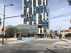
View of Callowhill from Chinatown
Street map of Philadelphia and surrounding area.png
Red pog.svg
Callowhill
Location of the Callowhill section of Philadelphia
Coordinates: 39°57′36″N75°09′29″W / 39.96°N 75.158°W / 39.96; -75.158
CountryFlag of the United States (23px).png  United States
State Pennsylvania
County Philadelphia
City Philadelphia
Area code(s) 215, 267, and 445

Callowhill is one of the unofficial names for a neighborhood in Philadelphia, Pennsylvania, located roughly in the vicinity of Callowhill Street, between Vine, Spring Garden, Broad, and 8th streets. The name "Callowhill" was coined by the Callowhill Neighborhood Association, a community organization in the area; [1] although this name often appears on online maps, the City of Philadelphia does not have an official name for this area. Callowhill is named for Callowhill Street, which was named after Hannah Callowhill Penn, William Penn's second wife and de facto proprietor of Pennsylvania after William Penn.

Contents

Callowhill was formerly home to large-scale manufacturing and other industries, of which an architectural history has been left in the form of grand old abandoned factories. [2] During the 1970s and 1980s, the population of Callowhill plummeted, and although numbers are rising, it is a fairly unpopulated section of the city compared to surrounding neighborhoods. Recently developers have started to employ adaptive reuse projects, converting them into loft style housing; so much so that many have termed the neighborhood "The Loft District". [3] In 2010 the Callowhill Industrial Historic District was added to the National Register of Historic Places. [4]

Callowhill is physically cut off from its neighbor to the south, Chinatown, by the Vine Street Expressway. This has largely prevented Chinese businesses from spreading north, although some industrial and storage uses by the Chinese community have been placed in Callowhill. [5] Vine Street is also blamed for the abrupt drop in pedestrian life above Chinatown, and the struggle faced by efforts to redevelop this section of the city that lies between Center City and North Philadelphia. [6]

Reading Viaduct in the Callowhill neighborhood Reading Viaduct.jpg
Reading Viaduct in the Callowhill neighborhood
Crowds attending the opening of The Rail Park. The Rail Park opening day in Philadelphia on June 14, 2018.jpg
Crowds attending the opening of The Rail Park.

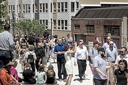
The former Reading Railroad train trestle, the Reading Viaduct, is a defining feature of the Callowhill neighborhood. [7] Neighborhood groups proposed that the abandoned structure be maintained as a public park. The Reading Viaduct park plan gained momentum in 2009 when Philadelphia's Center City District (CCD), and its influential president Paul Levy, became enamored of the idea and ultimately became a partner to help manage the project. [8] CCD announced on Tuesday, February 6, 2018 that the first phase of the quarter-mile-long, elevated park would open in spring 2018. [9] The actual grand opening of The Rail park was held on June 14, 2018, attracting a large crowd. [10]

Philadelphia Traffic Court is in Callowhill, at Spring Garden Street and North 8th Street.

See also

Related Research Articles

<span class="mw-page-title-main">Philadelphia</span> Largest city in Pennsylvania, United States

Philadelphia, commonly referred to as Philly, is the most populous city in the U.S. state of Pennsylvania and the second-most populous city in the Northeast megalopolis and Mid-Atlantic regions after New York City. Philadelphia is known for its extensive contributions to United States history, especially the American Revolution, and served as the nation's capital until 1800. It maintains contemporary influence in business and industry, culture, sports, and music. Philadelphia is the nation's sixth-most populous city with a population of 1,603,797 as of the 2020 census and is the urban core of the larger Delaware Valley, the nation's seventh-largest and one of the world's largest metropolitan regions consisting of 6.245 million residents in the metropolitan statistical area and 7.366 million residents in its combined statistical area.

<span class="mw-page-title-main">Interstate 676</span> Highway in New Jersey and Pennsylvania

Interstate 676 (I-676) is an Interstate Highway that serves as a major thoroughfare through Center City Philadelphia, where it is known as the Vine Street Expressway, and Camden, New Jersey, where it is known as the northern segment of the North–South Freeway, as well as the Martin Luther King Jr. Memorial Highway in honor of civil rights leader Martin Luther King Jr. Its western terminus is at I-76 in Philadelphia near the Philadelphia Museum of Art and Fairmount Park. From there, it heads east and is then routed on surface streets near Franklin Square and Independence National Historical Park, home of the Liberty Bell, before crossing the Delaware River on the Benjamin Franklin Bridge. On the New Jersey side of the bridge, the highway heads south to its southern terminus at I-76 in Gloucester City near the Walt Whitman Bridge. Between the western terminus and downtown Camden, I-676 is concurrent with U.S. Route 30 (US 30).

<span class="mw-page-title-main">Reading Viaduct</span> Disused elevated rail line and park

The Reading Viaduct, also called The Rail Park, is a disused elevated rail line in the Callowhill district of Philadelphia, Pennsylvania, United States that has been partly transformed into a rail trail.

<span class="mw-page-title-main">Center City Commuter Connection</span> Railway tunnel in Center City Philadelphia

The Center City Commuter Connection (CCCC), commonly referred to as "the commuter tunnel", is a passenger railroad tunnel in Center City, Philadelphia, Pennsylvania, United States, built to connect the stub ends of the two separate regional commuter rail systems, originally operated by two rival railroad companies: the Pennsylvania Railroad and the Reading Company. All of the SEPTA Regional Rail lines except for the Cynwyd Line pass completely through the four-track tunnel, which contains two underground stations, Suburban Station and Jefferson Station, and the above-ground upper-level concourse for the east–west commuter lines serving 30th Street Station.

<span class="mw-page-title-main">Transportation in Philadelphia</span>

Transportation in Philadelphia involves the various modes of transport within the city and its required infrastructure. In addition to facilitating intracity travel, Philadelphia's transportation system connects Philadelphia to towns of its metropolitan area and surrounding areas within the Northeast megalopolis.

<span class="mw-page-title-main">University City, Philadelphia</span> Neighborhood of Philadelphia in Philadelphia County, Pennsylvania, United States

University City is the easternmost portion of West Philadelphia, encompassing several Philadelphia universities. It is situated directly across the Schuylkill River from Center City.

<span class="mw-page-title-main">Northern Liberties, Philadelphia</span> Former District in Pennsylvania, United States

Northern Liberties is a neighborhood in Philadelphia, Pennsylvania, United States. It is north of Center City along the Delaware River. Prior to its incorporation into Philadelphia in 1854, it was among the top 10 largest cities in the U.S. in every census from 1790 to 1850. It was a major manufacturing area that attracted many European immigrants in the late 19th and early 20th centuries. In the early 21st century, it has attracted many young professionals and new commercial and residential development

<span class="mw-page-title-main">Overbrook, Philadelphia</span> Neighborhood of Philadelphia in Philadelphia County, Pennsylvania, United States

Overbrook is an historic neighborhood that is located in the Commonwealth of Pennsylvania, United States. It is situated northwest of West Philadelphia, Philadelphia.

<span class="mw-page-title-main">Center City, Philadelphia</span> Neighborhood in Philadelphia, Pennsylvania

Center City includes the central business district and central neighborhoods of Philadelphia, Pennsylvania, United States. It comprises the area that made up the City of Philadelphia prior to the Act of Consolidation, 1854, which extended the city borders to be coterminous with Philadelphia County.

<span class="mw-page-title-main">Chinatown, Philadelphia</span> Neighborhood of Philadelphia in Pennsylvania, United States

Philadelphia Chinatown is a predominantly Asian American neighborhood in Center City, Philadelphia, Pennsylvania. The Philadelphia Chinatown Development Corporation supports the area. The neighborhood stretches from Vine Street on the north, Arch Street on the south; North Franklin Street and N. 7th Street on the east; to North Broad Street on the west.

<span class="mw-page-title-main">Old City, Philadelphia</span> United States historic place

Old City is a neighborhood in Center City, Philadelphia, Pennsylvania, United States, near the Delaware River waterfront. It is home to Independence National Historical Park, a dense section of historic landmarks including Independence Hall, the Liberty Bell, the First Bank of the United States, the Second Bank of the United States, and Carpenters' Hall. It also includes historic streets such as Elfreth's Alley, dating back to 1703.

<span class="mw-page-title-main">SEPTA Route 15</span> SEPTA trolley line in Philadelphia, Pennsylvania

Route 15, the Girard Avenue Line, is a trolley line operated by the Southeastern Pennsylvania Transportation Authority (SEPTA) along Girard Avenue through North and West Philadelphia, Pennsylvania, United States. As of 2007, it is the only surface trolley line in the City Transit Division that is not part of the Subway–Surface Trolley Lines. SEPTA PCC II vehicles are used on the line.

<span class="mw-page-title-main">Franklin Square (Philadelphia)</span> United States historic place

Franklin Square is one of the five original open-space parks planned by William Penn when he laid out the city of Philadelphia, Pennsylvania, in 1682. It is located in the Center City area, between North 6th and 7th streets, and between Race Street and the Vine Street Expressway (I-676).

<span class="mw-page-title-main">Spring Garden, Philadelphia</span> Historic neighborhood in Pennsylvania, United States

Spring Garden is a neighborhood in central Philadelphia, Pennsylvania, bordering Center City on the north. Spring Garden is a neighborhood that combines diverse residential neighborhoods and significant cultural attractions.

<span class="mw-page-title-main">Poplar, Philadelphia</span> Neighborhood of Philadelphia in Pennsylvania, United States

Poplar is a neighborhood in Lower North Philadelphia, Pennsylvania, United States. It is located north of Callowhill, between Spring Garden/Fairmount and Northern Liberties, bounded roughly by Girard Avenue to the north, North Broad Street to the west, Spring Garden Street to the south, and 5th Street to the east. The neighborhood is predominantly residential, with commercial frontage on Broad Street and Girard Avenue and some industrial facilities to the west of the railroad tracks along Percy St. and 9th St.

Gentrification is the controversial process of affluent people moving into a historically low-income neighborhood. It is often criticized because the current residents have limited options to buy or rent equivalent housing in alternative areas at the same price. If they stay, prices for products, services, and taxes rise and existing social networks are disturbed. Gentrification is the opposite of white flight—when residents voluntarily move away as a neighborhood declines.

Callowhill Depot is a bus and trolley barn operated by the Southeastern Pennsylvania Transportation Authority (SEPTA), located in West Philadelphia, near the Delaware County border. It was built in 1913 by the Philadelphia Rapid Transit Company (PRT) and was later operated by the Philadelphia Transportation Company (PTC) before being taken over by SEPTA. The depot was constructed as part of the Thomas E. Mitten modernization program. Since its construction, the depot has suffered fire damage and reconstruction in 1949, 1950, and 1995.

Sarah McEneaney is an American artist, painter, and community activist who lives and works in Philadelphia, Pennsylvania. Working primarily in egg tempera her paintings are characterized by their autobiographical content, detailed brushwork, and brilliant color. McEneaney's intimate subject matter focuses on daily scenes from her home, studio, travels, and neighborhood. Her work is included in public collections such as the Philadelphia Museum of Art and she has received numerous grants and awards. McEneaney is also active in community work, including the formation of the Callowhill Neighborhood Association in 2001, and the co-founding of the Reading Viaduct Project in 2003.

<span class="mw-page-title-main">30th Street Station District</span>

The 30th Street Station District, also referred to as the 30th Street District, is a master planned urban development centered around 30th Street Station located in West Philadelphia in Philadelphia, Pennsylvania, United States. The area, if approved and built, will be home to eight modern skyscrapers or high rises ranging in heights between 405 ft and1,200 ft with four other buildings under 400 feet. The property will be owned by Amtrak and will be a major addition to the City of Philadelphia. The project is expected to cost between seven and eleven billion dollars.

References

  1. "About CNA | Callowhill Neighborhood Association". callowhill.org. Retrieved 2022-03-21.
  2. "The Life And Death Of Callowhill | Hidden City Philadelphia". hiddencityphila.org. Retrieved 2018-10-02.
  3. Loft District Property Phillymag, 27/03/2015.
  4. "Gritty Callowhill is recognized as National Historic District". PlanPhilly | Gritty Callowhill is recognized as National Historic District. Retrieved 2018-10-02.
  5. Chinatown tries to stay in Chinatown Phillymag, 02/11/16
  6. Steuteville, Robert (2016-08-09). "USDOT seeks to reconnect Philly neighborhoods". CNU. Retrieved 2018-10-02.
  7. "History - Reading Viaduct Project". Reading Viaduct Project. Retrieved 2018-10-02.
  8. Blumgart, Jake (October 31, 2016). "First phase of Rail Park construction underway". Plan Philly. Retrieved April 6, 2018.
  9. Romero, Melissa (February 7, 2018). "Rail Park opening delayed until spring 2018". Curbed Philly. Retrieved April 6, 2018.
  10. "PHOTOS: Philadelphia's First Rail Park Is Officially Open". Philadelphia Magazine. 2018-06-14. Retrieved 2018-10-02.

[[Category:Broad Street (Philadelphia)