Rhawnhurst, Philadelphia

Last updated

Rhawnhurst
Rhawnhurst2.JPG
The intersection of Rhawn Street and Castor Avenue in Rhawnhurst
Street map of Philadelphia and surrounding area.png
Red pog.svg
Rhawnhurst
Coordinates: 40°03′43″N75°03′00″W / 40.062°N 75.050°W / 40.062; -75.050
CountryFlag of the United States.svg  United States
State Pennsylvania
County Philadelphia County
City Philadelphia
ZIP code
19152, parts of 19111
Area code(s) 215, 267 and 445

Rhawnhurst is a residential neighborhood in the Northeast section of Philadelphia, Pennsylvania, United States, named for George and William Rhawn by area real estate developers. [1] Roughly bordered by Cottman Avenue to the south, Pennway Street to the west, the Pennypack Creek to the north, and Roosevelt Boulevard to the east, Rhawnhurst encompasses ZIP codes 19152 and part of ZIP code 19111. The geographic center of Rhawnhurst is at the intersection of Castor Avenue and Rhawn Street.

Contents

History

By 1940, development in Philadelphia had almost reached Cottman Avenue, [2] but large areas of the Northeast, including Rhawnhurst, were still farmland. [3] Though much development had taken place in neighboring Mayfair, the area between Pennypack Park and Cottman Avenue west of the Roosevelt Boulevard had not been subdivided. [4] The baby boom after World War II caused a demand for housing that continued into the 1960s. The new housing stock was built in the open areas of Northeast Philadelphia. Most homes in Rhawnhurst are twins, along with some ranchers and duplexes, largely built by local home builder A.P. Orleans.

Transportation

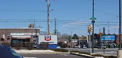
The two major modes of transportation in Rhawnhurst are private car and public transportation. Major roads include Cottman Avenue (PA 73), Bustleton Avenue (PA 532), Castor Avenue, Rhawn Street, and the Roosevelt Boulevard (U.S. 1). The intersection of Cottman Avenue and the Roosevelt Boulevard is one of the most dangerous in the city; recently red light cameras were installed there to reduce traffic violations. (In a ranking done by State Farm Insurance in 2001, 2 of the 10 most dangerous intersections in the U.S. were on the Roosevelt Boulevard. [5] ) Several SEPTA bus lines serve Rhawnhurst, with connections to the Market-Frankford Line elevated train (the "El"), the Broad Street Line, and regional rail lines.

Infrastructure and government

The United States Postal Service operates the Roosevelt Mall branch at 2311 Cottman Avenue. This post office serves the communities in 19152. [6] Residents in the portion of Rhawnhurst in 19111 get mail from the Fox Chase post office, located on 7232 Rising Sun Ave.

Education

There are five primary and secondary schools in Rhawnhurst.

The School District of Philadelphia operates four schools in Rhawnhurst. Farrell Elementary School, a K-8 school, [7] opened 1960s during the buildup of the Bell's Corner section of Rhawnhurst.[ citation needed ] Rhawnhurst Elementary School, which serves another section of the area, [8] opened in 1948 during a period of growth in the neighborhood.[ citation needed ] Castor Gardens Middle School, which predates the neighborhood and though on the south side of Cottman Avenue,[ citation needed ] is the middle school serving those zoned to Rhawnhurst Elementary. [9] Northeast High School is the zoned high school. [10] The current building is a replacement for the old Northeast High School building at 8th Street and Lehigh Avenue, opened in 1957.[ citation needed ]

A parochial school, Resurrection of Our Lord Catholic School, opened in 1929 and is operated by the Roman Catholic Archdiocese of Philadelphia.

Houses of worship

Rhawnhurst is home to people of several faiths. Resurrection and BVM are the only Roman Catholic churches in Rhawnhurst. Major Protestant churches include Redemption Lutheran Church (1929), the Rhawnhurst Baptist Church, All Saints Episcopal Church, the Rhawnhurst Presbyterian Church (1929), the Philadelphia First Church of the Nazarene and the Philadelphia Boulevard Seventh-day Adventist Church. There are several synagogues and Jewish congregations in Rhawnhurst including Ahavas Torah, Beth Medrash Harav, B'nai Israel – Ohev Zedek, The Lubavitcher Center, Mesillat Yesharim and Congregation Dibrot Eliyahu.

Shopping

There is very little industry in Rhawnhurst. There is, however, commercial development. Major shopping centers include the Bell's Corner Shopping Center, the Cottman Bustleton Center, and the Roosevelt Mall, which opened in 1964 at Cottman Avenue and the Roosevelt Boulevard. Many smaller storefronts also line Castor Avenue, Bustleton Avenue, and Cottman Avenue.

Recreation

The major recreation attraction in Rhawnhurst is Pennypack Park, one of the largest urban parks in the U.S., and the northern border of the neighborhood. Bradford Park, a smaller park popular as a dog park is located near the Roosevelt Mall. The Pelbano Recreation Center (colloquially called "Solly" because of its location on Solly Avenue), is a playground operated by the City of Philadelphia. Other recreational destinations include the Northeast Regional Library.

Ruben Amaro, Jr. Amaro Jr.jpg
Rubén Amaro, Jr.

Notable people

Related Research Articles

<span class="mw-page-title-main">Fox Chase, Philadelphia</span> Neighborhood of Philadelphia in Philadelphia, Pennsylvania

Fox Chase is a neighborhood in Northeast Philadelphia, Pennsylvania, United States, neighbouring Oxford Circle and Rhawnhurst.

<span class="mw-page-title-main">Northeast Philadelphia</span> Neighborhood of Philadelphia in Philadelphia, Pennsylvania, United States

Northeast Philadelphia, nicknamed Northeast Philly, the Northeast and the Great Northeast, is a section of Philadelphia, Pennsylvania. According to the 2000 census, Northeast Philadelphia has a population of between 300,000 and 450,000, depending on how the area is defined. Beginning in the 1980s, many of the Northeast's working class children graduated from college and settled in suburbs, especially nearby Bucks County. The Northeast is known as being home to a large working class Irish American population, but it is also home to Polish, German, Jewish, Italian, African American, Portuguese, Brazilian, Russian, Puerto Rican, Dominican, Ukrainian, Indian, Chinese, and Vietnamese neighborhoods.

<span class="mw-page-title-main">Frankford, Philadelphia</span> Former Borough in Pennsylvania, United States

Frankford is a neighborhood in the Northeast section of Philadelphia situated about six miles (10 km) northeast of Center City. Although its borders are vaguely defined, the neighborhood is bounded roughly by the original course of Frankford Creek on the south to Castor Avenue on the northwest and southwest, to Cheltenham Avenue on the north, and to Aramingo Avenue and I-95 on the east. [source: GoogleMaps] Adjacent neighborhoods are Bridesburg, Juniata, Northwood, Summerdale, and Wissinoming.

Roosevelt Boulevard, officially named the Theodore Roosevelt Memorial Boulevard and often referred to, chiefly by local Philadelphians, simply as "the Boulevard," is a major traffic artery through North and Northeast Philadelphia. The road begins at Interstate 76 in Fairmount Park, running as a freeway also known as the Roosevelt Boulevard Extension or the Roosevelt Expressway through North Philadelphia, then transitioning into a twelve-lane divided highway that forms the spine of Northeast Philadelphia to its end at the city line.

<span class="mw-page-title-main">Holmesburg, Philadelphia</span> Neighborhood of Philadelphia, Pennsylvania, US

Holmesburg began as a Village within Lower Dublin Township, Pennsylvania. It is now a neighborhood in the Northeast section of Philadelphia, Pennsylvania, United States. Holmesburg was named in Honor of Surveyor General of Pennsylvania Thomas Holme, who was a cartographer.

<span class="mw-page-title-main">Mayfair, Philadelphia</span> Neighborhood of Philadelphia in Philadelphia County, Pennsylvania, United States

Mayfair is a neighborhood in lower Northeast Philadelphia, Pennsylvania, United States, centered on the intersection of Cottman and Frankford Avenues. It is bordered by Tacony and Wissinoming to the south and east, Holmesburg to the east, Pennypack Park to the north, and Oxford Circle and Rhawnhurst to the west. Mayfair is historically home to a large Irish American population, but more recently has seen accelerated growth of Asian American population

<span class="mw-page-title-main">Bustleton, Philadelphia</span> Neighborhood of Philadelphia in Philadelphia County, Pennsylvania, United States

The Bustleton section of Northeast Philadelphia, United States is located in the Far Northeast, north of Rhawnhurst and Fox Chase and south of Somerton; sitting between Roosevelt Boulevard to the east, the city boundary to the west, Red Lion Road to the north, and Pennypack Park to the south, it is centered at the intersection of Grant Avenue and Bustleton Avenue (PA-532) and is completely included in the 19115 postal ZIP code.

<span class="mw-page-title-main">Pennypack Creek</span>

Pennypack Creek is a 22.6-mile-long (36.4 km) creek in southeastern Pennsylvania in the United States. It runs southeast through lower Bucks County, eastern Montgomery County and the northeast section of Philadelphia, before emptying into the Delaware River.

Lexington Park is a neighborhood in the Northeast section of Philadelphia, Pennsylvania, United States. It is bounded on the west by Roosevelt Boulevard, and on the north, east and south by Pennypack Park. The neighborhood is made up mostly of twin and single homes built in the years following World War II, and a few apartment buildings built not long thereafter. There are some commercial establishments along Rhawn Street and Roosevelt Boulevard. Convenience to the park makes it an attractive location for families with children. Lexington Park is also home to Nazareth Hospital.

<span class="mw-page-title-main">Somerton, Philadelphia</span> Neighborhood in Philadelphia, Pennsylvania, United States

Somerton is a neighborhood in the Far Northeast section of Philadelphia, Pennsylvania, United States. The neighborhood is bounded by Red Lion Road on the south, Roosevelt Boulevard on the east, East County Line Road and Poquessing Creek on the north, and the Philadelphia County / Montgomery County line on the west. Somerton is adjacent to the Philadelphia neighborhoods of Bustleton, Normandy, and Byberry, the townships of Bensalem and Lower Southampton in Bucks County, and Lower Moreland Township in Montgomery County. The area is home to a large and fast-growing foreign-born population, most notably of Russian, Ukrainian, Indian, and Central Asian immigrants.

<span class="mw-page-title-main">Oxford Circle, Philadelphia</span> Neighborhood of Philadelphia in Philadelphia County, Pennsylvania, United States

Oxford Circle is a neighborhood in the lower Northeast section of Philadelphia, Pennsylvania, United States. Its namesake is the much used traffic circle at Roosevelt Boulevard and Oxford Avenue. The Oxford Circle neighborhood has traditionally included the areas up to Rhawnhurst and Mayfair but does not really have a fixed boundary, other than in publications about Philadelphia which are of a public relations or informational nature.

<span class="mw-page-title-main">Pennsylvania Route 232</span> State highway in Pennsylvania, US

Pennsylvania Route 232 (PA 232) is a 25.2-mile-long (40.6 km) state highway located in southeastern Pennsylvania. The southern terminus of the route is at U.S. Route 1 (US 1)/US 13 at the Oxford Circle in Philadelphia. The northern terminus is at PA 32 in the borough of New Hope, Bucks County, on the banks of the Delaware River. The route passes through the urban areas of Northeast Philadelphia as Oxford Avenue, serving the Lawncrest, Burholme, and Fox Chase neighborhoods. Upon entering Montgomery County, PA 232 becomes Huntingdon Pike and through suburban areas, serving the communities of Rockledge, Huntingdon Valley, and Bryn Athyn. The route passes through more suburban development in Bucks County as Second Street Pike, running through Southampton and Richboro. In Wrightstown Township, PA 232 enters rural areas and becomes Windy Bush Road as it heads north to New Hope.

<span class="mw-page-title-main">Pennsylvania Route 73</span> State highway in Pennsylvania, US

Pennsylvania Route 73 (PA 73) is a 62.32-mile (100.29 km) long east–west state highway in southeastern Pennsylvania. It runs from PA 61 near Leesport southeast to the New Jersey state line on the Tacony–Palmyra Bridge over the Delaware River in Philadelphia, where the road continues south as New Jersey Route 73. The route passes through rural areas of Berks County, crossing U.S. Route 222 (US 222) in Maiden Creek before heading southeast through Oley and Boyertown. PA 73 continues into Montgomery County and intersects PA 100 in Gilbertsville and PA 29 in Schwenksville before it heads into the northwest suburbs of Philadelphia. The route passes through Skippack and intersects US 202 in Center Square, PA 309 in Springfield Township, and PA 611 near Jenkintown. PA 73 continues through Northeast Philadelphia on Cottman Avenue, crossing US 1 and US 13 before coming to an interchange with Interstate 95 (I-95) near the Tacony–Palmyra Bridge.

<span class="mw-page-title-main">U.S. Route 1 in Pennsylvania</span> Highway in Pennsylvania

U.S. Route 1 (US 1) is a major north–south U.S. Route, extending from Key West, Florida, in the south to Fort Kent, Maine, at the Canada–United States border in the north. In the U.S. state of Pennsylvania, US 1 runs for 81 miles (130 km) from the Maryland state line near Nottingham northeast to the New Jersey state line at the Delaware River in Morrisville, through the southeastern portion of the state. The route runs southwest to northeast and serves as a major arterial road through the city of Philadelphia and for many of the suburbs in the Delaware Valley metropolitan area. South of Philadelphia, the road mostly follows the alignment of the Baltimore Pike. Within Philadelphia, it mostly follows Roosevelt Boulevard. North of Philadelphia, US 1 parallels the route of the Lincoln Highway. Several portions of US 1 in Pennsylvania are freeways, including from near the Maryland state line to Kennett Square, the bypass of Media, the concurrency with Interstate 76 and the Roosevelt Expressway in Philadelphia, and between Bensalem Township and the New Jersey state line.

<span class="mw-page-title-main">SEPTA City Transit Division surface routes</span>

The City Transit Division of the Southeastern Pennsylvania Transportation Authority (SEPTA) operate almost all of Philadelphia's public transit, including all six trolley, three trackless trolley, and 70 bus lines within city limits. Some of the bordering municipalities are served by the City Transit division, despite not being part of the city. For example, Cheltenham Township has 13 city division routes and no Suburban Division ones. The City Transit division also operates the 400 Series routes which are designed to serve students attending schools in the city of Philadelphia.

<span class="mw-page-title-main">Castor Gardens, Philadelphia</span> Neighborhood of Northeast Philadelphia

Castor Gardens is a neighborhood in the lower Northeast section of Philadelphia, Pennsylvania, United States. Castor Gardens' borders are not clearly defined, but it exists in the vicinity of Castor Avenue and Cottman Avenue. It is also near Roosevelt Boulevard. The neighborhood can either be entered from the south, by taking the Oxford Circle exit of Roosevelt Boulevard, or from the north, by taking the Cottman Avenue exit. Adjacent neighborhoods are Mayfair, Lawndale, Burholme, Oxford Circle, and Rhawnhurst.

<span class="mw-page-title-main">U.S. Route 13 in Pennsylvania</span> Highway in Pennsylvania

U.S. Route 13 (US 13) is a United States Numbered Highway running from Fayetteville, North Carolina, north to Morrisville, Pennsylvania. The route runs for 49.359 miles (79.436 km) through the Delaware Valley in the U.S. state of Pennsylvania. The route enters the state from Delaware in Marcus Hook, Delaware County. It continues northeast through Delaware County, passing through the city of Chester before heading through suburban areas along Chester Pike to Darby. US 13 enters the city of Philadelphia on Baltimore Avenue and runs through West Philadelphia to University City, where it turns north along several city streets before heading east across the Schuylkill River along Girard Avenue. The route turns north and heads to North Philadelphia, where it runs northeast along Hunting Park Avenue. US 13 becomes concurrent with US 1 on Roosevelt Boulevard, continuing into Northeast Philadelphia. US 13 splits southeast on a one-way pair of streets before heading northeast out of the city on Frankford Avenue. The route continues into Bucks County as Bristol Pike, heading northeast to Bristol, where it turns into a divided highway. US 13 becomes a freeway in Tullytown and continues north to its terminus at US 1 in Falls Township, near Morrisville. US 13 roughly parallels Interstate 95 (I-95) through its course in Pennsylvania.

<span class="mw-page-title-main">Roosevelt Mall</span> Shopping mall in Northeast Philadelphia

Roosevelt Mall is a medium-sized outdoor shopping mall, located along Pennsylvania Route 73 between Bustleton Avenue west end and U.S. Route 1 in the east end, or Rhawnhurst neighborhood, of Northeast Philadelphia, Pennsylvania.

Winchester Park is a neighborhood in Far Northeast Philadelphia, Pennsylvania, United States. It is located in the vicinity of Pennypack Park, north and west of Holmesburg.

<span class="mw-page-title-main">National Register of Historic Places listings in Northeast Philadelphia</span>

This is a list of the National Register of Historic Places listings in Northeast Philadelphia.

References

  1. Philadelphia Neighborhoods and Place Names, Q-Z Philadelphia Information Locator Service May 20, 1998, retrieved April 10, 2006
  2. Miller, Frank; Morris Vogel; Allen Davis (1983). Still Philadelphia A Photographic History, 1890–1940. Philadelphia: Temple University Press. p.  254. ISBN   0-87722-306-8.
  3. Miller, Frank; Morris Vogel; Allen Davis (1983). Still Philadelphia A Photographic History, 1890–1940. Philadelphia: Temple University Press. p.  257. ISBN   0-87722-306-8.
  4. Miller, Frank; Morris Vogel; Allen Davis (1983). Still Philadelphia A Photographic History, 1890–1940. Philadelphia: Temple University Press. p.  272. ISBN   0-87722-306-8.
  5. "Philly road at top of danger list; fixes fairly cheap". USA Today. June 27, 2001. Retrieved May 22, 2010.
  6. ".""United States Postal Office". Retrieved on March 8, 2018.
  7. "Louis H. Farrell Elementary School Geographic Boundaries." School District of Philadelphia. Retrieved on December 11, 2016.
  8. "Rhawnhurst Elementary School Geographic Boundaries." School District of Philadelphia. Retrieved on December 11, 2016.
  9. "Woodrow Wilson Middle School Geographic Boundaries." School District of Philadelphia. Retrieved on December 11, 2016.
  10. "Northeast High School Geographic Boundaries Archived March 3, 2016, at the Wayback Machine ." School District of Philadelphia. Retrieved on December 11, 2016.