Narberth is a borough in Montgomery County, Pennsylvania. It is one of many neighborhoods on the historic Philadelphia Main Line. The population was 4,282 at the 2010 census.
Saint Joseph's University is a private Jesuit university in Philadelphia, Lower Merion Township, Pennsylvania, and Lancaster, Pennsylvania. The university was founded by the Society of Jesus in 1851 as Saint Joseph's College. Saint Joseph's is the seventh oldest Jesuit university in the United States and the sixth largest university in Philadelphia. It is named after Saint Joseph. It merged in 2022 with the University of the Sciences. In 2023, Saint Joseph's University announced it would acquire Pennsylvania College of Health Sciences. This will expand Saint Joseph's University by adding a campus in Lancaster, Pennsylvania and expanding the size of the student body especially with students studying nursing and health.
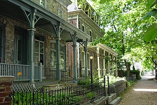
Powelton Village is a neighborhood of mostly Victorian, mostly twin homes in the West Philadelphia section of Philadelphia, Pennsylvania. It is a national historic district that is part of University City. Powelton Village extends north from Market Street to Spring Garden Street, east to 32nd Street, west to 40th and Spring Garden Streets, and to 44th and Market Streets.

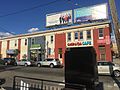
Fishtown is a neighborhood in the River Wards section of Philadelphia, Pennsylvania, United States. Located northeast of Center City Philadelphia, its borders are somewhat disputed today due to many factors, but are roughly defined by the triangle created by the Delaware River, Front Street, and York Street. Some newer residents expand the area to Lehigh Avenue to the northeast, while some older residents shrink the area to Norris Street. It is served by the Market–Frankford Line rapid transit subway/elevated line of the SEPTA system. Fishtown has long been a largely working class Irish Catholic and Irish American neighborhood, though in recent years it has seen a large influx of young urban professionals and gentrification.

University City is the easternmost portion of West Philadelphia, encompassing several Philadelphia universities. It is situated directly across the Schuylkill River from Center City.

Cedar Park is a neighborhood of Philadelphia, Pennsylvania, United States. Located in the larger West Philadelphia district, it stretches north to Larchwood Avenue, south to Kingsessing Avenue, east to 46th Street, and west to 52nd Street.

West Philadelphia, nicknamed West Philly, is a section of the city of Philadelphia. Although there are no officially defined boundaries, it is generally considered to reach from the western shore of the Schuylkill River, to City Avenue to the northwest, Cobbs Creek to the southwest, and the SEPTA Media/Wawa Line to the south. An alternate definition includes all city land west of the Schuylkill; this would also include Southwest Philadelphia and its neighborhoods. The eastern side of West Philadelphia is also known as University City.
The SEPTA subway–surface trolley lines are a collection of five SEPTA trolley lines that operate on street-level tracks in West Philadelphia and Delaware County, Pennsylvania, and also underneath Market Street in Philadelphia's Center City. The lines, Routes 10, 11, 13, 34, and 36, collectively operate on about 39.6 miles (63.7 km) of route.
Wynnewood is a suburban unincorporated community, located west of Philadelphia, straddling Lower Merion Township in Montgomery County, Pennsylvania and Haverford Township in Delaware County, Pennsylvania, United States.
Holmesburg began as a Village within Lower Dublin Township, Pennsylvania. It is now a neighborhood in the Northeast section of Philadelphia, Pennsylvania, United States. Holmesburg was named in Honor of Surveyor General of Pennsylvania Thomas Holme, who was a cartographer.

Mayfair is a working class neighborhood in lower Northeast Philadelphia, Pennsylvania, United States, centered on the intersection of Cottman and Frankford Avenues. It is bordered by Tacony and Wissinoming to the south and east, Holmesburg to the east, Pennypack Park to the north, and Oxford Circle and Rhawnhurst to the west. Mayfair is historically home to a large Irish American population, but more recently has seen accelerated growth of Asian American, Hispanic, Russian and mid eastern population
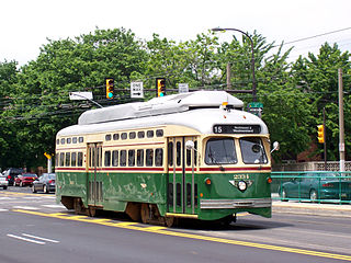
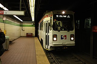
Route 15, currently rebranding as the G, is a street-running light rail line in the SEPTA Metro network that runs along Girard Avenue through North and West Philadelphia, Pennsylvania. Service is operated by the City Transit Division of the Southeastern Pennsylvania Transportation Authority. As of 2024, it is the only trolley line in Philadelphia that is not part of the subway–surface trolley lines. SEPTA PCC III vehicles are used on the line.
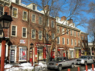
Society Hill is a historic neighborhood in Center City, Philadelphia, Pennsylvania, United States, with a population of 6,215 as of the 2010 United States Census. Settled in the early 1680s, Society Hill is one of the oldest residential neighborhoods in Philadelphia. After urban decay developed between the late 19th and early 20th centuries, an urban renewal program began in the 1950s, restoring the area and its many historic buildings. Society Hill has since become one of the most expensive neighborhoods with the highest average income and second-highest real estate values in Philadelphia. Society Hill's historic colonial architecture, along with planning and restoration efforts, led the American Planning Association to designate it, in 2008, as one of the great American neighborhoods and a good example of sustainable urban living.

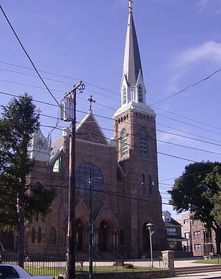
Bridesburg is the northernmost neighborhood in the River Wards section of Philadelphia, Pennsylvania, United States. A mostly working-class neighborhood, Bridgesburg is an historically German and Irish community, with a significant community of Polish immigrants who arrived mostly in the early- to mid-twentieth century. The community is home to two Catholic churches: All Saints Church, designed by Edwin Forrest Durang and built in 1889; and Saint John Cantius Church, built in 1898 in Polish cathedral style.

Pennsylvania Route 3 is a 24.3-mile (39.1 km) state highway located in the southeastern portion of Pennsylvania. The route runs from U.S. Route 322 Business in West Chester east to PA 611 in Philadelphia.

Walnut Hill is a neighborhood in the West Philadelphia section of Philadelphia, Pennsylvania, United States. It is located between 45th Street and 52nd Street, bounded by Market Street and Spruce Street. Most of the neighborhood is in the northwestern part of the University City District. It is located north of the neighborhoods of Garden Court and Spruce Hill.

40th Street station is an underground station on the SEPTA Market-Frankford Line, located the intersection of 40th Street and Market Street in Philadelphia, Pennsylvania, on the line between the Spruce Hill and Powelton Village neighborhoods in the University City District of West Philadelphia. The station serves a major shopping corridor of West Philadelphia on 40th Street, as well as the campus of the University of Pennsylvania, which lies three blocks south of the station.
Garden Court is a neighborhood in the West Philadelphia section of Philadelphia, Pennsylvania, United States. It is situated between 45th and 52nd Streets and stretches from Locust Street south to Cedar Street. There is overlap in area with the nearby neighborhoods of Walnut Hill, Spruce Hill, and Cedar Park.

U.S. Route 13 (US 13) is a United States Numbered Highway running from Fayetteville, North Carolina, north to Morrisville, Pennsylvania. The route runs for 49.359 miles (79.436 km) through the Delaware Valley metropolitan area in the U.S. state of Pennsylvania. The route enters the state from Delaware in Marcus Hook, Delaware County. It continues northeast through Delaware County, passing through the city of Chester before heading through suburban areas along Chester Pike to Darby. US 13 enters the city of Philadelphia on Baltimore Avenue and runs through West Philadelphia to University City, where it turns north along several city streets before heading east across the Schuylkill River along Girard Avenue. The route turns north and heads to North Philadelphia, where it runs northeast along Hunting Park Avenue. US 13 becomes concurrent with US 1 on Roosevelt Boulevard, continuing into Northeast Philadelphia. US 13 splits southeast on a one-way pair of streets before heading northeast out of the city on Frankford Avenue. The route continues into Bucks County as Bristol Pike, heading northeast to Bristol, where it becomes a divided highway. US 13 becomes a freeway in Tullytown and continues north to its terminus at US 1 in Falls Township, near Morrisville. US 13 roughly parallels Interstate 95 (I-95) through its course in Pennsylvania.

Girard Avenue is a major commercial and residential street in Philadelphia. For most of its length it runs east–west, but at Frankford Avenue it makes a 135-degree turn north. Parts of the road are signed as U.S. Route 13 and U.S. Route 30.