SEPTA Route 11

Last updated
Route 11
Subway–surface trolley line
SEPTA9001.jpg
SEPTA's Route #11 line bound for Darby
Overview
Termini
Stations8 underground stations, 1 surface level station, and 40 street-level stops
Service
System Subway–surface trolley lines
Depot(s) Elmwood Carhouse
Daily ridership13,480 (avg weekday 2019)
History
Opened1858
Technical
Line length13.3 mi (21.4 km)[ citation needed ]
Track gauge 5 ft 2+14 in (1,581 mm) Pennsylvania trolley gauge [1]
Electrification Overhead line,  600 V DC
Route map

Contents

BSicon tCONTg.svg
BSicon tSTR.svg
BSicon utCONTg.svg
MFL
BSicon tSTR.svg
BSicon HUBrg-R.svg
BSicon utdSTR+l.svg
BSicon cHUB-Lq.svg
BSicon HUB-Lq.svg
BSicon utINTACC.svg
BSicon utdSTR+r.svg
BSicon cHUB-Lq.svg
BSicon HUBlg-L.svg
13th Street
MFL
BSicon ulCONTg@Gq.svg
BSicon utSTRq.svg
BSicon tSTR.svg
BSicon HUB-R.svg
BSicon utdKRZto.svg
BSicon utdKRZto.svg
BSicon utdKRZto.svg
BSicon XPLTa.svg
BSicon utSTRq.svg
BSicon utINTq.svg
BSicon HUB-L.svg
BSicon ucCONTfq.svg
BSicon HUB-R.svg
BSicon tSTR.svg
BSicon GRZ+l.svg
BSicon utINT.svg
BSicon utSTR~L.svg
BSicon lINTACC-L.svg
BSicon HUBa@f-R.svg
BSicon HUB-Rq.svg
BSicon utSTR~R.svg
BSicon utINTACC-R.svg
BSicon lINTACC-R.svg
BSicon XPLTr.svg
BSicon HUBrf-L.svg
15th Street
MFL
BSicon HUBe.svg
BSicon GRZe.svg
BSicon tINT.svg
BSicon lINTACC.svg
BSicon utSTR.svg
BSicon utSTR~L.svg
BSicon utSTR.svg
BSicon utSTR~R.svg
BSicon htSTRe.svg
BSicon dNULf.svg
BSicon utdHST-L.svg
BSicon utdpHST-M.svg
BSicon dNULg.svg
BSicon utdHST-R.svg
19th Street
BSicon hSTR.svg
BSicon dNULf.svg
BSicon utdHST-L.svg
BSicon utdpHST-M.svg
BSicon dNULg.svg
BSicon utdHST-R.svg
22nd Street
BSicon hKRZW.svg
BSicon utdKRZW.svg
BSicon utdKRZW.svg
BSicon utdKRZW.svg
BSicon MASKr.svg
BSicon WASSERq.svg
BSicon lCONTg@Gq.svg
BSicon lINTACC-Rq.svg
BSicon hKRZ.svg
BSicon umtdKRZ.svg
BSicon umtdKRZ.svg
BSicon umtdKRZ.svg
BSicon CONTfq.svg
BSicon hSTRe@f.svg
BSicon GRZa.svg
BSicon lINTACC-Lq.svg
BSicon utSTR.svg
BSicon utSTR~L.svg
BSicon utSTR.svg
BSicon utSTR~R.svg
BSicon STR.svg
BSicon GRZl.svg
BSicon utSTR~L.svg
BSicon lINTACC-L.svg
BSicon utINT.svg
BSicon utINTACC-R.svg
BSicon lINTACC-R.svg
BSicon utSTR~R.svg
30th Street
MFL
BSicon lCONTg@Gq.svg
BSicon KRZhl.svg
BSicon lhdSTRq.svg
BSicon umtdKRZ.svg
BSicon lhdSTRq.svg
BSicon umtdKRZ.svg
BSicon lhdSTRq.svg
BSicon umtdKRZ.svg
BSicon hCONTfq.svg
BSicon tABZ3l.svg
BSicon lCONTf3.svg
BSicon PORTALa.svg
BSicon extSTR3+l.svg
BSicon umtdKRZtu.svg
BSicon tCONTfq.svg
BSicon utdSTRc2.svg
BSicon lMKRXo.svg
BSicon utvSHI2l-.svg
BSicon utv-SHI2+l.svg
BSicon utv-STR3.svg
BSicon utvSHI2r-.svg
BSicon ulCONTg@Gq.svg
BSicon utcdSTRr+1.svg
BSicon utdSTRc4.svg
BSicon utdSTR.svg
MFL
BSicon utHST.svg
33rd Street
BSicon PORTALl.svg
BSicon uCONTg@Gq.svg
BSicon utABZgr.svg
  10  
BSicon utHST.svg
36th Street
BSicon utHST.svg
37th Street
BSicon utHSTe@g.svg
40th Street Portal
BSicon uCONTgq.svg
BSicon uSTR+r.svg
BSicon uKRWgr.svg
  34   Baltimore Avenue
BSicon ueHST.svg
Chester & Woodland
BSicon uLSTR+l.svg
BSicon udSTRq.svg
BSicon uABZgr.svg
  13   Chester Avenue
BSicon uLSTRe.svg
BSicon ueBHF(L)g.svg
Woodland & 41st
BSicon uCONTgq.svg
BSicon uHST.svg
BSicon uABZg+r.svg
Woodland & 42nd
Diversion tracks to 40th & Market
BSicon uBHF(R)f.svg
Woodland & 43rd
BSicon uBHF(L)g.svg
Woodland & 45th
BSicon uHST.svg
Woodland & 46th
BSicon ueBHF(L)g.svg
Woodland & 47th
BSicon CONTgq.svg
BSicon umKRZo.svg
BSicon CONTfq.svg
WAW
BSicon uHST.svg
Woodland & 48th
BSicon uBHF(R)f.svg
Woodland & 49th
BSicon udCONTgq.svg
BSicon udABZq+lr.svg
BSicon uABZqr+r.svg
BSicon uABZgl.svg
BSicon uCONTfq.svg
  36  Pfeil rechts.svg 49th Street
BSicon uYRD.svg
BSicon uSTR.svg
Woodland Heavy Maintenance Shop
BSicon udSTRl.svg
BSicon ulHST.svg
BSicon uABZgr+r.svg
Woodland & 50th
BSicon uHST.svg
Woodland & 51st
BSicon uHST.svg
Woodland & 52nd
BSicon uHST.svg
Woodland & 53rd
BSicon uHST.svg
Woodland & 54th
BSicon uHST.svg
Woodland & 55th
BSicon uHST.svg
Woodland & 56th
BSicon uHST.svg
Woodland & 57th
BSicon uCONTgq.svg
BSicon uHST.svg
BSicon uABZgr+r.svg
Woodland & 58th
Non-Revenue Track to Chester Ave.
BSicon CONTgq.svg
BSicon umTBHFo.svg
BSicon CONTfq.svg
Woodland & 60th
CSX Philadelphia Subdivision
BSicon uHST.svg
Woodland & 61st
BSicon uHST.svg
Woodland & 62nd
BSicon uHST.svg
Woodland & 63rd
BSicon uHST.svg
Woodland & 64th
BSicon uHST.svg
Woodland & 65th
BSicon uHST.svg
Woodland & 66th
BSicon uHST.svg
Woodland & 67th
BSicon uHST.svg
Woodland & 68th
BSicon uHST.svg
Woodland & 69th
BSicon uHST.svg
Woodland & 70th
BSicon uHST.svg
Woodland & 71st
BSicon uHST.svg
Woodland & 72nd
BSicon uHST.svg
BSicon uABZgl+l.svg
BSicon uCONTfq.svg
Woodland & Island
Non-Revenue Track to Elmwood Ave.
BSicon uWBRUCKE1.svg
BSicon uHST.svg
Main & Front
BSicon uHST.svg
Main & 2nd
BSicon uHST.svg
Main & 3rd
BSicon uHST.svg
Main & 4th
BSicon uHST.svg
Main & 5th
BSicon CONTgq.svg
BSicon umKRZ.svg
BSicon CONTfq.svg
BSicon uHST.svg
Main & 6th
BSicon uHST.svg
Main & Summit
BSicon uLSTRa.svg
BSicon uBHF(L)g.svg
Main & Mill
BSicon uLSTR.svg
BSicon uBHF(R)f.svg
Main & Powell
BSicon udSTRl-.svg
BSicon udSTR.svg
BSicon udSTR+l-.svg
BSicon ulvHST@F-.svg
BSicon dNULf.f.svg
BSicon udSTRq-.svg
BSicon dNULgq-.svg
BSicon udSTRq-.svg
BSicon udSTRr-.svg
BSicon udSTR.svg
Darby T.C.   13  
BSicon udSTRl-.svg
BSicon udSTRl-.svg
BSicon udSTRq-.svg
BSicon dNULfq-.svg
BSicon udSTRq-.svg
BSicon udSTRr-.svg

Route 11, also known as the Woodland Avenue Line, is a trolley line operated by the Southeastern Pennsylvania Transportation Authority (SEPTA) that connects the 13th Street station in downtown Philadelphia, Pennsylvania, to Darby Transportation Center in Darby, Pennsylvania. It is one of five lines that are part of the subway–surface trolley system. Sitting at an average of 13,580 riders per weekday in 2019, it is the most used subway-surface trolley route, even though it lacks overnight service.

Route description

Starting from its eastern end at 13th Street, Route 11 runs in a tunnel under Market Street. It stops at underground stations at 15th Street, 19th Street, 22nd Street, 30th Street, and 33rd Street. From 15th to 30th Streets, it runs on the outer tracks in the same tunnel as SEPTA's Market–Frankford Line.

Passengers may transfer free of charge to the Market–Frankford Line at 13th, 15th, and 30th Streets and to the Broad Street Line at 15th Street. Connections to the SEPTA Regional Rail are also available. Underground passageways connect the 13th and 15th Street Stations to Jefferson Station and Suburban Station.

Route 11 surfaces at the 40th Street Portal near 40th Street and Baltimore Avenue (US 13), and then runs southwest along Woodland Avenue, along with Route 36 trolleys, and then turns down 49th Street where the Route 10 diversion line ends. Route 11 continues its run along Woodland Avenue, and is the most consistent of the five subway–surface lines when it comes to taking a straight route. The line runs parallel to the north side of the Wilmington/Newark Line and crosses a bridge over CSX's Philadelphia Subdivision freight line, at 60th Street.

At the intersection of Island Road and the Cobbs Creek Parkway, an unnamed line runs southward toward Elmwood Depot on the corner of Elmwood Avenue, which is a major turning point for the Route 36 line. The northwest corner is also the home of the historic Blue Bell Inn [2] Route 11 moves northwest from Woodland Avenue to Main Street as it crosses the Cobbs Creek and enters Darby. Here, Route 11 crosses the Philadelphia Subdivision again, but at an at-grade crossing along with 6th Street. [3] The road and line move to the west shortly, only to turn back northwest and finally north to 9th Street at the Darby Transportation Center. Some Route 13 trolleys also terminate at the station, but the other public transportation consists of SEPTA Suburban Transit Division buses.

History

Route 11 was established as the West Philadelphia Passenger Railway Company in Darby on December 24, 1858, and ran as horsecars from 9th and Main Streets in Darby to 49th Street and Woodland Avenue in West Philadelphia. It was originally a segregated streetcar that required African-Americans to ride on platforms along with the driver, until abolitionist William Still challenged that rule between 1859 and 1867. [4] In 1896, the line was extended as far east as Front Street via Chestnut and Walnut Streets, and was integrated into the subway–surface trolley system by the Philadelphia Rapid Transit Company on December 15, 1906. [5]

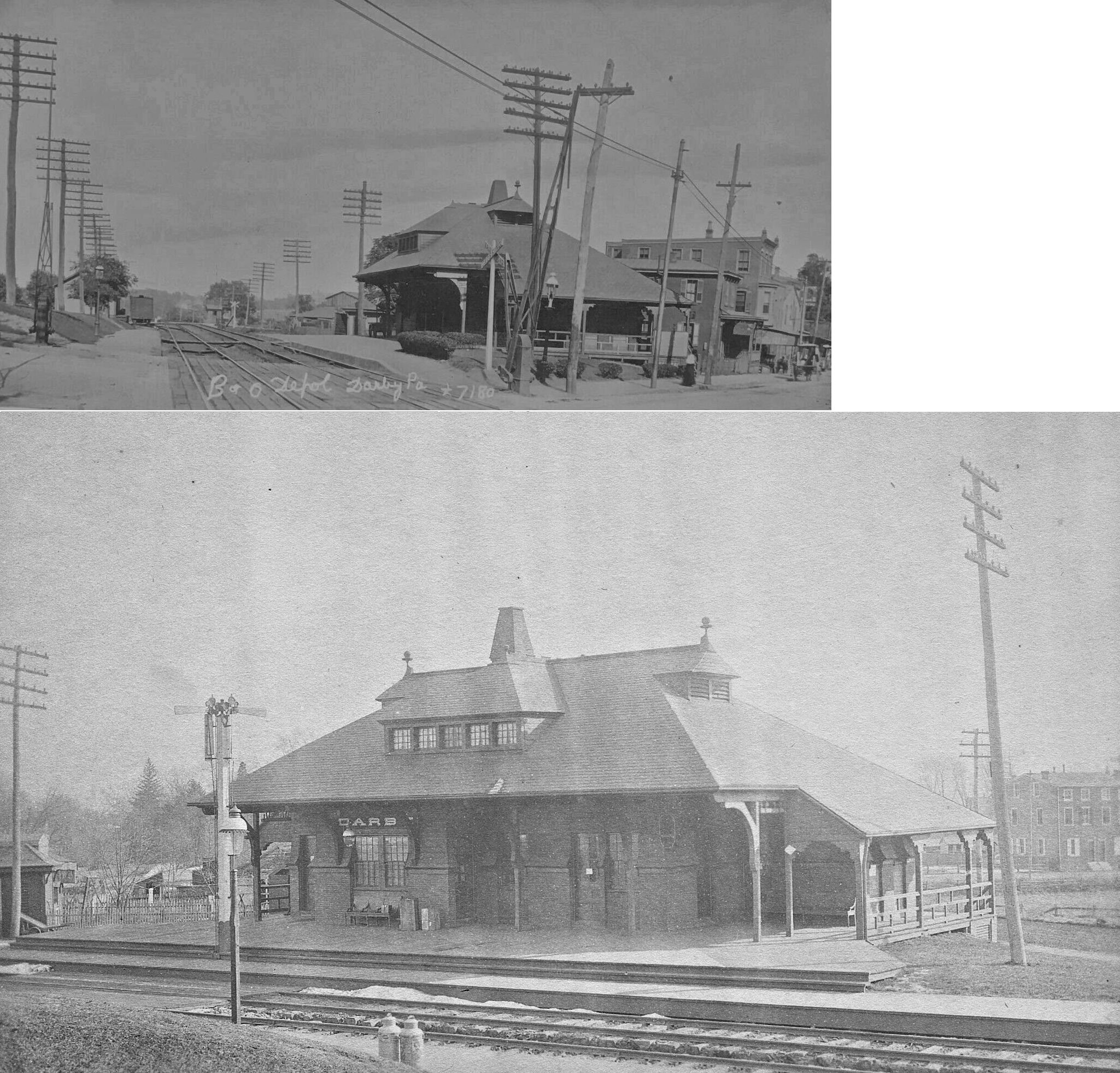
The at-grade crossing along Main Street at the intersection of Sixth Street in Darby [6] was the site of the Darby Baltimore and Ohio Railroad station. B&O had passenger service into Philadelphia until 1958. [7]

On December 9, 2021, a Route 11 trolley collided with a CSX Transportation freight train operating on the Philadelphia Subdivision at the at-grade crossing between the two lines near the intersection of Main Street and Sixth Street in Darby. Seven people on the trolley were injured, and the front windshield was smashed. [8] All of the people injured in the crash were treated and released from the hospital on the same day. [9] This is reportedly the only intersection in the nation where an active freight rail line crosses a fixed active rail transit line. [10]

In 2021, SEPTA proposed rebranding their rail transit service as "SEPTA Metro", in order to make the system easier to navigate. Under this proposal, the subway–surface lines will be rebranded as the "T" lines with a green color and numeric suffixes for each service, and Route 11 would be renamed "T4 Woodland Avenue." [11] [12] SEPTA described that "most comments were positive" in the public comment period for this rebranding project. [13]

Stations and stops

All are in either the City of Philadelphia or the Borough of Darby.

Neighborhood/
location
ImagesStation or stopConnectionsNotes
Market East 13th Street trolley 1.jpg 13th Street SEPTA.svg BSicon SUBWAY.svg MFL Market–Frankford Line
SEPTA.svg BSicon TRAM.svg 10, 11, 13, 34, 36
SEPTA.svg Bus-logo.svg 27, 31, 32
Closed between 12:30–5:00am
Penn Center 15th Street SEPTA 2018 trolley.JPG 15th Street SEPTA.svg Aiga railtransportation 25.svg all lines (at Suburban)
SEPTA.svg BSicon SUBWAY.svg MFL Market–Frankford Line, BSL Broad Street Line (at City Hall)
SEPTA.svg BSicon TRAM.svg 10, 11, 13, 34, 36
SEPTA.svg Bus-logo.svg 4, 16, 17, 27, 31, 32, 33, 38, 44, 48
SEPTA.svg BSicon BUS2.svg 124, 125
Late night terminus
SEPTA Subway-Surface underground.jpg 19th Street SEPTA.svg BSicon TRAM.svg 10, 11, 13, 34, 36
SEPTA.svg Bus-logo.svg 17, 31, 38, 44, 48, 62, 78
SEPTA.svg BSicon BUS2.svg 124
Center City West 22nd Street trolley station Philadelphia.jpg 22nd Street SEPTA.svg BSicon TRAM.svg 10, 11, 13, 34, 36
SEPTA.svg Bus-logo.svg 7, 31, 44, 62
SEPTA.svg BSicon BUS2.svg 124, 125
Replaced 24th Street station
University City 30th Street Trolley Station 2.jpg 30th Street BSicon LOGO Amtrak2.svg Amtrak (at 30th Street)
NJT logo.svg NJ Transit: ACL Atlantic City Line (at 30th Street)
SEPTA.svg Aiga railtransportation 25.svg all lines (at 30th Street)
SEPTA.svg BSicon SUBWAY.svg MFL Market–Frankford Line
SEPTA.svg BSicon TRAM.svg 10, 11, 13, 34, 36
SEPTA.svg Bus-logo.svg 31, 49, LUCY
No direct passage to 30th Street Station
33rd Street station SEPTA 2018a.jpg 33rd Street SEPTA.svg BSicon TRAM.svg 10, 11, 13, 34, 36
SEPTA.svg Bus-logo.svg 30, 31, 49, LUCY
Serves Drexel University
36th Street Station SEPTA.jpg 36th Street SEPTA.svg BSicon TRAM.svg 13 , 34 , 36
SEPTA.svg Bus-logo.svg 21
Serves University of Pennsylvania
37th Street Station 2018c.jpg 37th Street SEPTA.svg BSicon TRAM.svg 13 , 34 , 36
SEPTA.svg Bus-logo.svg 40 , 42 , LUCY
Serves University of Pennsylvania, Children's Hospital of Philadelphia
Spruce Hill SEPTA K-Car Subway Surface.jpg 40th Street Portal SEPTA.svg BSicon TRAM.svg 13 , 34 , 36
SEPTA.svg Bus-logo.svg 30 , 40 , 42 , LUCY
End of Route 34 concurrency
Chester & Woodland SEPTA.svg BSicon TRAM.svg 13 , 36
SEPTA.svg Bus-logo.svg 30
End of Route 13 concurrency
41st & Woodland (EB) SEPTA.svg BSicon TRAM.svg 36
SEPTA.svg Bus-logo.svg 30
42nd & Woodland SEPTA.svg BSicon TRAM.svg 36
43rd & Woodland (WB)
45th & Woodland (EB)
SEPTA.svg BSicon TRAM.svg 36
Squirrel Hill 46th & Woodland SEPTA.svg BSicon TRAM.svg 36
47th & Woodland (EB) SEPTA.svg BSicon TRAM.svg 36
Kingsessing 48th & Woodland SEPTA.svg BSicon TRAM.svg 36
Woodland49.jpg 49th & Woodland SEPTA.svg BSicon TRAM.svg 36
SEPTA.svg Bus-logo.svg 12 , 52 , 64
End of Route 36 concurrency
50th & Woodland SEPTA.svg Bus-logo.svg 12 , 52
51st & Woodland SEPTA.svg Bus-logo.svg 52
52nd & Woodland SEPTA.svg Bus-logo.svg 52
53rd & Woodland SEPTA.svg Bus-logo.svg 52
54th & Woodland
55th & Woodland
56th & Woodland
57th & Woodland
58th & Woodland SEPTA.svg Bus-logo.svg G
Elmwood 60th & Woodland
61st & Woodland
Woodland&62nd.jpg 62nd & Woodland SEPTA.svg Bus-logo.svg G
63rd & Woodland
64th & Woodland
65th & Woodland SEPTA.svg BSicon BUS2.svg 108
66th & Woodland
67th & Woodland
68th & Woodland
69th & Woodland
70th & Woodland
71st & Woodland
72nd & Woodland
Island & Woodland SEPTA.svg Bus-logo.svg 68
Philadelphia–Darby line
Darby Front & Main
2nd & Main
3rd & Main
4th & Main
5th & Main
6th & Main
Summit & Main
Mill & Main (EB)
Powell & Main (WB)
SEPTA LRV at Darby, June 2008.jpg Darby T.C. SEPTA.svg BSicon TRAM.svg 13
SEPTA.svg BSicon BUS2.svg 113 , 114 , 115
Limited Route 13 service

Related Research Articles

<span class="mw-page-title-main">SEPTA</span> Public transportation authority

The Southeastern Pennsylvania Transportation Authority (SEPTA) is a regional public transportation authority that operates bus, rapid transit, commuter rail, light rail, and electric trolleybus services for nearly four million people in five counties in and around Philadelphia, Pennsylvania. It also manages projects that maintain, replace and expand its infrastructure, facilities and vehicles.

<span class="mw-page-title-main">Market–Frankford Line</span> SEPTA rapid transit line in Philadelphia, Pennsylvania

The Market–Frankford Line (MFL), or the Blue Line) is one of three rapid transit lines in Philadelphia, Pennsylvania; it and the Broad Street Line are operated by SEPTA, and the PATCO Speedline is operated by PATCO. The Market–Frankford Line runs from the 69th Street Transportation Center in Upper Darby, just outside of West Philadelphia, through Center City Philadelphia to the Frankford Transportation Center in Near Northeast Philadelphia.

<span class="mw-page-title-main">Transportation in Philadelphia</span>

Transportation in Philadelphia involves the various modes of transport within the city and its required infrastructure. In addition to facilitating intracity travel, Philadelphia's transportation system connects Philadelphia to towns of its metropolitan area and surrounding areas within the Northeast megalopolis.

<span class="mw-page-title-main">SEPTA Routes 101 and 102</span> Light rail lines in Delaware County, Pennsylvania

SEPTA Routes 101 and 102, also known as the Media–Sharon Hill Line, are light rail lines operated by the Suburban Transit Division of the Southeastern Pennsylvania Transportation Authority, serving portions of Delaware County. The routes' eastern terminus is 69th Street Transportation Center in Upper Darby Township, Pennsylvania. Route 101 runs to Media, while Route 102 goes to Sharon Hill. Altogether, the two lines operate on approximately 11.9 miles (19.2 km) of route. The lines were formerly interurbans.

<span class="mw-page-title-main">69th Street Transportation Center</span> Rapid transit station in Philadelphia

The 69th Street Transportation Center is a SEPTA terminal in the Terminal Square section of Upper Darby Township, Pennsylvania. It serves the Market–Frankford Line, Norristown High Speed Line, and SEPTA Routes 101 and 102 trolleys, and multiple bus routes. It is located at the end of 69th Street, a major retail corridor in Upper Darby Township across Market Street from the Tower Theater. Until 2011, the station was primarily known as 69th Street Terminal.

<span class="mw-page-title-main">West Philadelphia</span> Neighborhood of Philadelphia, Pennsylvania

West Philadelphia, nicknamed West Philly, is a section of the city of Philadelphia. Although there are no officially defined boundaries, it is generally considered to reach from the western shore of the Schuylkill River, to City Avenue to the northwest, Cobbs Creek to the southwest, and the SEPTA Media/Wawa Line to the south. An alternate definition includes all city land west of the Schuylkill; this would also include Southwest Philadelphia and its neighborhoods. The eastern side of West Philadelphia is also known as University City.

<span class="mw-page-title-main">SEPTA subway–surface trolley lines</span> Philadelphia trolley lines

The SEPTA subway–surface trolley lines are a collection of five SEPTA trolley lines that operate on street-level tracks in West Philadelphia and Delaware County, Pennsylvania, and also underneath Market Street in Philadelphia's Center City. The lines, Routes 10, 11, 13, 34, and 36, collectively operate on about 39.6 miles (63.7 km) of route.

<span class="mw-page-title-main">SEPTA Route 15</span> SEPTA trolley line in Philadelphia, Pennsylvania

Route 15, the Girard Avenue Line, is a trolley line operated by the Southeastern Pennsylvania Transportation Authority (SEPTA) along Girard Avenue through North and West Philadelphia, Pennsylvania, United States. As of 2007, it is the only surface trolley line in the City Transit Division that is not part of the Subway–Surface Trolley Lines. SEPTA PCC II vehicles are used on the line.

<span class="mw-page-title-main">Darby station</span> SEPTA station

Darby station is a SEPTA Regional Rail station in Darby, Pennsylvania. It is located on the Northeast Corridor at 4th and Colwyn Streets, and serves the Wilmington/Newark Line.

<span class="mw-page-title-main">SEPTA Route 13</span> Philadelphia trolley line

SEPTA Route 13, also known as the Chester Avenue Line, is a trolley line operated by the Southeastern Pennsylvania Transportation Authority (SEPTA) that connects 13th Street Station in downtown Philadelphia, Pennsylvania, with Yeadon and Darby, Pennsylvania. It is one of five lines that are part of the Subway-Surface Trolley system.

<span class="mw-page-title-main">40th Street Portal</span> SEPTA Subway-Surface Lines trolley station

The 40th Street Portal, also known as simply 40th Street station, is a SEPTA Subway-Surface Lines trolley station in Philadelphia. At this station's portal, four of the five Subway-Surface Lines enter the Woodland Avenue subway tunnel after running on the street in Southwest Philadelphia and nearby suburbs. Eastbound trolleys run in the tunnel under the nearby campuses of the University of Pennsylvania and Drexel University to Center City Philadelphia. Westbound trolleys travel to the Philadelphia neighborhoods of Eastwick and Angora and the Delaware County suburbs of Yeadon and Darby.

<span class="mw-page-title-main">SEPTA Route 34</span> Trolley line in Philadelphia, Pennsylvania

SEPTA's subway–surface trolley route 34, also called the Baltimore Avenue subway line, is a trolley line operated by the Southeastern Pennsylvania Transportation Authority (SEPTA) that connects the 13th Street station in downtown Philadelphia, Pennsylvania, to the Angora Loop station in the Angora neighborhood of West Philadelphia.

<span class="mw-page-title-main">SEPTA Route 36</span> Philadelphia trolley line

SEPTA's Subway-Surface Trolley Route 36 is a trolley line operated by the Southeastern Pennsylvania Transportation Authority (SEPTA) that connects the 13th Street station in downtown Philadelphia, Pennsylvania, to the Eastwick Loop station in Eastwick section of Southwest Philadelphia, although limited service is available to the Elmwood Carhouse. It is the longest of the five lines that are part of the Subway-Surface Trolley system, and was even longer between 1956 and 1962 when the western terminus was at 94th Street and Eastwick Avenue. From 1962 through the 1970s, it was at 88th Street and Eastwick Avenue, making the route 16.2 miles (26.1 km) long. Since 1975, it only goes as far as what was once 80th Street at the southern edge of the Penrose Plaza shopping center parking lot.

<span class="mw-page-title-main">SEPTA Route 10</span> Philadelphia trolley line

SEPTA Route 10, also known as the Lancaster Avenue Line, is a trolley line operated by the Southeastern Pennsylvania Transportation Authority (SEPTA) that connects the 13th Street station in Center City Philadelphia, Pennsylvania, to the 63rd Street–Malvern Avenue station in the Overbrook section of West Philadelphia. It is one out of five lines that is part of the SEPTA's subway–surface trolley system and is 11.6 mi (18.7 km) long. It is the least used subway-surface trolley line, but unlike Route 11, the most used subway-surface trolley line, it has overnight service.

<span class="mw-page-title-main">37th Street station (SEPTA)</span> Subway station in Philadelphia, Pennsylvania

37th Street station, also known as 37th Street/Spruce Street/Woodland Avenue station, is a SEPTA subway–surface lines trolley station in Philadelphia. It is westernmost station of the subway–surface tunnel and carries Routes 11, 13, 34, and 36. The station is located on the campus of the University of Pennsylvania at the intersection of 37th and Spruce streets.

<span class="mw-page-title-main">Olney Transportation Center</span> Rapid transit station in Philadelphia

The Olney Transportation Center, also called Olney Terminal, is a SEPTA bus and subway station in Philadelphia, Pennsylvania. It is located at the intersection of Broad Street and Olney Avenue in the Logan neighborhood of Northwest Philadelphia. It is a major bus terminal as well as the last subway stop on the Broad Street Line before the Fern Rock Transportation Center terminus.

<span class="mw-page-title-main">Pennsylvania Route 3</span> State highway in Chester, Delaware, and Philadelphia counties in Pennsylvania, US

Pennsylvania Route 3 is a 24.3-mile (39.1 km) state highway located in the southeastern portion of Pennsylvania. The route runs from U.S. Route 322 Business in West Chester east to PA 611 in Philadelphia.

<span class="mw-page-title-main">40th Street station (Market–Frankford Line)</span> Rapid transit station in Philadelphia

40th Street station is an underground station on the SEPTA Market-Frankford Line, located the intersection of 40th Street and Market Street in Philadelphia, Pennsylvania, on the line between the Spruce Hill and Powelton Village neighborhoods in the University City District of West Philadelphia. The station serves a major shopping corridor of West Philadelphia on 40th Street, as well as the campus of the University of Pennsylvania, which lies three blocks south of the station.

<span class="mw-page-title-main">SEPTA Route 60</span> Bus route in Philadelphia

SEPTA's Trolley Route 60, the Allegheny Avenue Line is a former streetcar line and current bus route, operated by the Southeastern Pennsylvania Transportation Authority (SEPTA) in Northwest and Northeast Philadelphia, Pennsylvania, United States. It connects to the East Falls to the Port Richmond, and runs primarily along Allegheny Avenue.

<span class="mw-page-title-main">SEPTA Route 29</span> Bus route in South Philadelphia

SEPTA Route 29 is a former streetcar and trackless trolley line and current bus route, operated by the Southeastern Pennsylvania Transportation Authority (SEPTA) in South Philadelphia, Pennsylvania, United States. The line runs between the Gray's Ferry neighborhood and the vicinity of Pier 70 along the Delaware River.

References

  1. Hilton, George W.; Due, John Fitzgerald (1 Jan 2000). The Electric Interurban Railways in America. Stanford University Press. ISBN   9780804740142 . Retrieved 2014-06-10.
  2. Blue Bell Inn (DarbyHistory.com)
  3. Philadelphia Transit; Streetcars;Route 11 (Kavanaugh Transit Systems)
  4. "William Still, Darby, and the Desegregation of Philadelphia Streetcars". DarbyHistory.com. Retrieved 2021-12-10.
  5. 1974 SEPTA Trolleys Brochure
  6. Google view of the crossing in Darby
  7. Former Darby B&O Station (Existing Railroad Stations in Delaware County, Pennsylvania)
  8. Rushing, Ellie (December 9, 2021). "SEPTA trolley collided with freight train in Delco, 6 passengers injured". Philadelphia Inquirer . Retrieved December 10, 2021.
  9. McCormick, Annie (December 9, 2021). "6 injured after SEPTA trolley collides with freight train in Darby, Pennsylvania". 6abc Action News . Retrieved December 10, 2021.
  10. Petrillo, Matt (December 9, 2021). "6 People Injured In Accident Involving SEPTA Trolley, CSX Freight Train In Darby". CBS Philadelphia . Retrieved December 10, 2021.
  11. Vitarelli, Alicia; Staff (September 7, 2021). "SEPTA Metro? Transit agency mulling big changes including new name, map, and signage". Philadelphia, PA: WPVI-TV. Retrieved September 7, 2021.
  12. "Wayfinding Recommendations". SEPTA. Retrieved September 7, 2021.
  13. "Design Concept Feedback". planning.septa.org. SEPTA. Retrieved 2023-03-19.
Template:Attached KML/SEPTA Route 11
KML is from Wikidata