Upper North Philadelphia

Last updated
Upper North Philadelphia
Phila FLP LehighAvenue02.png
Lillian Marrero Branch of the Philadelphia Free Library is located in Upper North Philadelphia's West Kensington
NPhilaDistrict.PNG
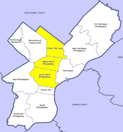
Map of Philadelphia County with North Philadelphia highlighted. Click for larger image
Country Flag of the United States.svg  United States of America
State Flag of Pennsylvania.svg  Pennsylvania
County Flag of Philadelphia, Pennsylvania.svg Philadelphia
City Flag of Philadelphia, Pennsylvania.svg Philadelphia
Area
  Total44.4 sq mi (115 km2)
Population
 (2010)
  Total181,531
  Density12,241/sq mi (4,726/km2)
ZIP code
19122, 19132, 19133, 19134, 19140

Upper North Philadelphia is a section of Philadelphia that is immediately north of Lower North Philadelphia, and can be described as an area that has a "...large and rapidly growing Puerto Rican population". [1]

Contents

According to the planning commission, Upper North Philadelphia officially consists of the Allegheny West, Fairhill, Glenwood, Hunting Park, and Nicetown-Tioga neighborhoods. Bounded by York Street to the south, Front Street to the east, Roosevelt Expressway to the north, and Ridge Avenue to the west.

Demographics

The demographics of Upper North Philadelphia shows that the area has a population density of 12,241 people per mile with an average household size of 3 and 37% of households had children. There is a 17% annual residential turnover rate with 47% of residents staying for more than 5 years, with an average of 6 years of residency. The majority of residents are African Americans and Puerto Ricans. [2]

Racial demographics [3] [4]

Related Research Articles

<span class="mw-page-title-main">Brownsville, Florida</span> Census-designated place in Florida

Brownsville is an unincorporated community and census-designated place (CDP) that is part of the Miami metropolitan area of South Florida. As of the 2020 US census, the population was 16,583, up from 15,313 in 2010. After three decades of population loss, Brownsville gained population for the first time in over 40 years in the 2010 US Census.

<span class="mw-page-title-main">Richmond West, Florida</span> Census-designated place in Florida

Richmond West is a census-designated place (CDP) in Miami-Dade County, Florida, United States. It is part of the Miami metropolitan area of South Florida. The population was 35,884 at the 2020 census, up from 31,973 at the 2010 census.

<span class="mw-page-title-main">West Little River, Florida</span> CDP in Miami-Dade County, Florida, US

West Little River is a census-designated place (CDP) in Miami-Dade County, Florida, United States. It is part of the Miami metropolitan area of South Florida. The population was 34,128 at the 2020 census.

<span class="mw-page-title-main">West Perrine, Florida</span> Census-designated place in Florida

West Perrine is a census-designated place (CDP) in Miami-Dade County, Florida, United States. It is part of the Miami metropolitan area of South Florida. The population was 10,602 at the 2020 census, up from 9,460 in 2010.

<span class="mw-page-title-main">Paxtang, Pennsylvania</span> Borough in Pennsylvania, United States

Paxtang is a borough in Dauphin County, Pennsylvania, United States. As of the 2020 census it had a population of 1,640. The borough is a suburb of Harrisburg and is one of the earliest colonial settlements in South Central Pennsylvania.

<span class="mw-page-title-main">Boothwyn, Pennsylvania</span> Census-designated place in Pennsylvania, United States

Boothwyn is a census-designated place (CDP) in Delaware County, Pennsylvania, United States. The population was 4,933 at the 2010 census, down from 5,206 at the 2000 census. The census estimation for population circa 2019 is 6,115.

<span class="mw-page-title-main">Broomall, Pennsylvania</span> Census-designated place in Pennsylvania, United States

Broomall is a census-designated place (CDP) in Marple Township, Delaware County, Pennsylvania, United States. The population was 10,789 at the 2010 census.

<span class="mw-page-title-main">Clifton Heights, Pennsylvania</span> Borough in Pennsylvania, United States

Clifton Heights is a borough in Delaware County, Pennsylvania, United States, located on Darby Creek 5 miles (8 km) west of downtown Philadelphia. As of the 2010 census, the population was 6,652.

<span class="mw-page-title-main">East Lansdowne, Pennsylvania</span> Borough in Pennsylvania, United States

East Lansdowne is a borough in Delaware County, Pennsylvania, United States. The population was 2,668 at the 2010 census.

<span class="mw-page-title-main">Folcroft, Pennsylvania</span> Borough in Pennsylvania, United States

Folcroft is a borough in Delaware County, Pennsylvania, United States. The population was 6,606 at the 2010 census, down from 6,978 at the 2000 census.

<span class="mw-page-title-main">Folsom, Pennsylvania</span> Census-designated place in Pennsylvania, United States

Folsom is a census-designated place (CDP) in Delaware County, Pennsylvania, United States. It is part of Ridley Township. The population was 8,323 at the 2010 census.

<span class="mw-page-title-main">Sharon Hill, Pennsylvania</span> Borough in Pennsylvania, United States

Sharon Hill is a borough in Delaware County, Pennsylvania, United States. The population was 5,697 at the 2010 census. Currently the population stands at 6,356 residents.

<span class="mw-page-title-main">Yeadon, Pennsylvania</span> Borough in Pennsylvania, United States

Yeadon is a borough in Delaware County, Pennsylvania, United States. It borders the city of Philadelphia. The population was 11,443 at the 2010 census.

<span class="mw-page-title-main">Chester Township, Delaware County, Pennsylvania</span> Home rule municipality in Pennsylvania, United States

Chester Township is a township in Delaware County, Pennsylvania, United States. The population was 3,940 at the 2010 census, down from 4,604 at the 2000 census.

<span class="mw-page-title-main">North Philadelphia</span> Neighborhood of Philadelphia in Philadelphia, Pennsylvania

North Philadelphia, nicknamed North Philly, is a section of Philadelphia, Pennsylvania. It is immediately north of Center City. Though the full extent of the region is somewhat vague, "North Philadelphia" is regarded as everything north of either Vine Street or Spring Garden Street, between Northwest Philadelphia and Northeast Philadelphia. It is bordered to the north by Cheltenham Township along Cheltenham Avenue, Spring Garden Street to the south, 35th Street to the west and Adams Avenue to the east. The Philadelphia Police Department patrols five districts located within North Philadelphia: the 22nd, 25th, 26th, 35th and 39th districts. There are fifteen ZIP codes for North Philadelphia: 19120, 19121, 19122, 19123, 19125, 19126, 19130, 19132, 19133, 19134, 19137, 19138, 19140, 19141, and 19150.

<span class="mw-page-title-main">Fairhill, Philadelphia</span> Neighborhood of Philadelphia in Pennsylvania, United States

Fairhill is a neighborhood on the east side of the North Philadelphia section of Philadelphia, Pennsylvania, United States. Fairhill is bordered by Front Street to the east, Germantown Avenue to the west, Allegheny Avenue to the north, and Cumberland Street to the south. The neighborhood serves as the center of the Hispanic community of Philadelphia, and is known for its "El Centro de Oro" commercial strip along North 5th Street. Fairhill is adjacent to Harrowgate and West Kensington to the east, Hartranft to the south, Glenwood to the west, and Hunting Park to the north.

<span class="mw-page-title-main">Demographics of Philadelphia</span>

At the 2010 census, there were 1,526,006 people, 590,071 households, and 352,272 families residing in the consolidated city-county of Philadelphia, Pennsylvania. The population density was 4,337.3/km2 (11,233.6/mi2). There were 661,958 housing units at an average density of 1,891.9/km2 (4,900.1/mi2).

<span class="mw-page-title-main">Stateside Puerto Ricans</span> Ethnic group and nationality and citizens of Puerto Rico in the US

Stateside Puerto Ricans, also ambiguously known as Puerto Rican Americans, or Puerto Ricans in the United States, are Puerto Ricans who are in the United States proper of the 50 states and the District of Columbia who were born in or trace any family ancestry to the unincorporated US territory of Puerto Rico.

The District of Columbia is a federal district with an ethnically diverse population. In 2020, the District had a population of 689,545 people, with a resident density of 11,515 people per square mile.

<span class="mw-page-title-main">North Camden</span> Populated place in Camden County, New Jersey, US

North Camden is a district of Camden, New Jersey. The population is 7,874. Cooper Point and Pyne Point are located in the area.

References

  1. Guian A. McKee (15 June 2010). The Problem of Jobs: Liberalism, Race, and Deindustrialization in Philadelphia. ISBN   9780226560144.
  2. "Upper North Philadelphia, Philadelphia, PA Real Estate Demographics".
  3. "Factfinder at census.gov". Archived from the original on 2020-02-12. Retrieved 2013-08-24.
  4. "2010 Census". Medgar Evers College. Archived from the original on 2010-06-11. Retrieved 2010-04-13.

39°59′08″N75°09′49″W / 39.98552°N 75.16358°W / 39.98552; -75.16358