
Kensington is a neighborhood in Philadelphia that belongs to Lower Northeast. As with all neighborhoods in the city, the lack of any official designation means the boundaries of the area vary between sources over time and are disputed among locals. Kensington, as most long-term residents view it, refers generally to the area consisting of Kensington, East Kensington, West Kensington, and Harrowgate. The adjacent Fairhill and Norris Square neighborhoods are more separate but may be included in Kensington; Fishtown and South (Olde) Kensington were historically included. The most conservative boundaries of the neighborhood, shown in the map below, are Front Street and 5th Street to the west, the Amtrak train tracks to the North, Trenton Avenue, the Trenton Avenue train tracks, and Frankford Avenue to the east, and Cecil B. Moore Avenue to the south.

North Philadelphia, nicknamed North Philly, is a section of Philadelphia, Pennsylvania. It is immediately north of Center City. Though the full extent of the region is somewhat vague, "North Philadelphia" is regarded as everything north of either Vine Street or Spring Garden Street, between Northwest Philadelphia and Northeast Philadelphia. It is bordered to the north by Olney Ave along Broad Street, Spring Garden Street to the south, 35th Street to the west and Adams Avenue to the east. The Philadelphia Police Department patrols five districts located within North Philadelphia: the 22nd, 25th, 26th, 35th and 39th districts. There are thirteen ZIP codes for North Philadelphia: 19120, 19121, 19122, 19123, 19125, 19126, 19130, 19132, 19133, 19134, 19137, 19140 and 19141.

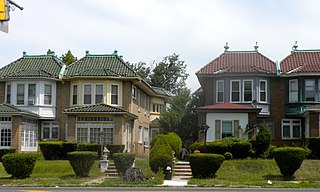
Port Richmond is a neighborhood in the River Wards section of Philadelphia, Pennsylvania, United States. It is notable for its extremely large Polish immigrant and Polish American community, and it has been known as the Little Poland of Philadelphia. The neighborhood is also home to a large Irish American community and sizable German, Lithuanian, Italian, and Puerto Rican communities, along with a historic Jewish community, as represented in the various churches and organizations. In more recent years, a sizable Albanian community has moved in. The Richmond Zip Code is 19134. A small portion of the neighborhood, north of Castor Avenue, falls into the 19137 ZIP code.

Olney is a neighborhood in the North Philadelphia section of Philadelphia. It is roughly bounded by Roosevelt Boulevard to the south, Tacony Creek to the east, Godfrey Avenue to the north, and the railroad right-of-way west of 7th Street to the west.

West Kensington is a neighborhood in the North Philadelphia section of Philadelphia, Pennsylvania, United States. It is north of Olde Kensington. The Market Frankford El above Front Street forms the line between West Kensington and Kensington. Its bordering neighborhoods are Kensington to the east, Hartranft to the west, and Olde Kensington to the south. It is bounded by Front Street to the east, 6th Street to the west, Cecil B. Moore Avenue to the south and Lehigh Avenue to the north. It falls into the 19122 and 19133 ZIP codes.
Cobbs Creek is a neighborhood located in the West Philadelphia section of Philadelphia, Pennsylvania, United States, named for the creek which forms part of Philadelphia's western border. Cobbs Creek is generally bounded by Market Street to the north, Baltimore Avenue to the south South 50th Street, Whitby Avenue, Angora Subway System, and Cobbs Creek Park

Cecil B. Moore is a neighborhood in the North Philadelphia section of the city of Philadelphia, Pennsylvania, United States, named after the late Philadelphia-based civil rights attorney and politician Cecil B. Moore. The district is loosely arranged around the main campus of Temple University. The neighborhood has gentrified due to an influx of Temple students during the past several years. The controversial term "Templetown" was coined by former Temple president Peter J. Liacouras, but has only recently come into wide use after a real estate development company adopted the name. Cecil B. Moore Avenue is a major east-west street running through the neighborhood, where it intersects with N. Broad Street in Temple’s campus.
Logan is a neighborhood in the upper North Philadelphia section of the city of Philadelphia, in the U.S. state of Pennsylvania. The majority of the neighborhood falls within the 19141 zip code, but some of it falls within 19140. The neighborhood is sometimes confused with the Olney neighborhood of Philadelphia. Olney Avenue extends from both the Olney and Logan neighborhoods of the city. The Olney Transportation Center is located in Logan.

Fairhill is a neighborhood on the east side of the North Philadelphia section of Philadelphia, Pennsylvania, United States. Fairhill is bordered by Front Street to the east, Germantown Avenue to the west, Allegheny Avenue to the north, and Cumberland Street to the south. The neighborhood serves as the center of the Hispanic community of Philadelphia, and is known for its "El Centro de Oro" commercial strip along North 5th Street. Fairhill is adjacent to Harrowgate and West Kensington to the east, Hartranft to the south, Glenwood to the west, and Hunting Park to the north.
North Central is an area in the North Philadelphia section of Philadelphia, Pennsylvania, United States. The name of the area is derived from its location, near the center of North Philadelphia. According to Census 2010, North Central is primarily a low-income neighborhood where 60% of its residents are African American and 40% are Puerto Rican. Hartranft and Stanton are neighborhoods locally known as "North Central". North Central borders both North Philadelphia East and North Philadelphia West.

Overbrook Farms is a neighborhood that is situated on the western edge of the West Philadelphia section of Philadelphia, Pennsylvania, United States. It is roughly bounded by City Avenue, 58th Street, Woodbine Avenue, and 66th Street at Morris Park.
Harrowgate is a neighborhood in the River Wards section of Philadelphia, Pennsylvania, United States, located immediately northeast of Kensington adjacent to Kensington Avenue. It is bordered by Feltonville, Juniata and Frankford to the north, Fairhill to the west, West Kensington and Kensington to the south, and Port Richmond and Bridesburg to the east.
Elmwood Park, also known simply as Elmwood, is a neighborhood in the Southwest section of Philadelphia, Pennsylvania, United States. It borders the city line with Delaware County at Cobbs Creek, and extends to the Schuylkill River. The Eastwick neighborhood borders it to the southwest, and Kingsessing borders it on the northeast.

Oxford Circle is a neighborhood in the lower Northeast section of Philadelphia, Pennsylvania, United States. Its namesake is the much used traffic circle at Roosevelt Boulevard and Oxford Avenue. The Oxford Circle neighborhood has traditionally included the areas up to Rhawnhurst and Mayfair but does not really have a fixed boundary, other than in publications about Philadelphia which are of a public relations or informational nature.

Haddington is a neighborhood in the West Philadelphia section of Philadelphia, Pennsylvania, United States. Its borders are defined as Haverford Avenue/Girard Avenue to the north, 52nd Street to the east, Market Street to the south, and 67th Street to the westernmost edge of the neighborhood.

Castor Gardens is a neighborhood in the lower Northeast section of Philadelphia, Pennsylvania, United States. Castor Gardens' borders are not clearly defined, but it exists in the vicinity of Castor Avenue and Cottman Avenue. It is also near Roosevelt Boulevard. The neighborhood can either be entered from the south, by taking the Oxford Circle exit of Roosevelt Boulevard, or from the north, by taking the Cottman Avenue exit. Adjacent neighborhoods are Mayfair, Lawndale, Burholme, Oxford Circle, and Rhawnhurst.

Packer Park is a neighborhood in the South Philadelphia section of Philadelphia, Pennsylvania, United States that originally included 1,000 homes built in two unique builder developments, of Packer Park in the 1950s and Brinton Estates during the 1990s. It is now one of four residential communities to be designated as Packer Park. The original footprint community is also one of four adjacent communities that form Philadelphia's Sports Complex Special Services District. The approximate boundaries are Packer Avenue to the north, Hartranft Street to the south including FDR Park farther south, Broad Street to the east known as the Southern Parkway, and I-76 to the far west. Packer Park has been considered home to one of the most organized community groups in the South Philadelphia region.
North Philadelphia East is a neighborhood that is located in the eastern central part of North Philadelphia section of Philadelphia, Pennsylvania, United States.
North Philadelphia West is a neighborhood that is located in the western central part of the North Philadelphia section of Philadelphia, Pennsylvania, United States, east of the Schuylkill River.

