
Wilmington is the most populous city in the U.S. state of Delaware. The city was built on the site of Fort Christina, the first Swedish settlement in North America. It lies at the confluence of the Christina River and Brandywine Creek, near where the Christina flows into the Delaware River. It is the county seat of New Castle County and one of the major cities in the Delaware Valley metropolitan area. Wilmington was named by Proprietor Thomas Penn after his friend Spencer Compton, Earl of Wilmington, who was prime minister during the reign of George II of Great Britain.

John Franklin Street is an American politician and lawyer who served as the 97th Mayor of the City of Philadelphia. He was first elected to a term beginning on January 3, 2000, and was re-elected to a second term beginning in 2004. He is a Democrat and became mayor after having served 19 years in the Philadelphia City Council, including seven years as its president, before resigning as required under the Philadelphia City Charter in order to run for mayor. He followed Ed Rendell as mayor, assuming the post on January 3, 2000. Street was Philadelphia's second black mayor.
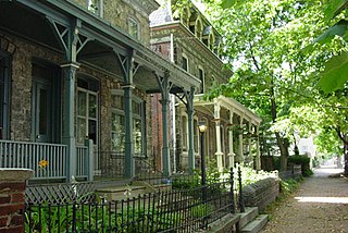
Powelton Village is a neighborhood of mostly Victorian, mostly twin homes in the West Philadelphia section of Philadelphia, Pennsylvania. It is a national historic district that is part of University City. Powelton Village extends north from Market Street to Spring Garden Street, east to 32nd Street, west to 40th and Spring Garden Streets, and to 44th and Market Streets.

Harrisburg University of Science & Technology, commonly referred to as Harrisburg University (HU), is a private STEM-focused university in Harrisburg, Pennsylvania, with an additional location in Philadelphia. Founded in 2001 as Harrisburg Polytechnic Institute, it offers STEM-focused degree and certificate programs.

The Near West Side, one of the 77 community areas of Chicago, is on the West Side, west of the Chicago River and adjacent to the Loop. The Great Chicago Fire of 1871 started on the Near West Side. Waves of immigration shaped the history of the Near West Side of Chicago, including the founding of Hull House, a prominent settlement house. The near west side comprises several neighborhoods. In the 19th century railroads became prominent features. In the mid-20th century, the area saw the development of freeways centered in the Jane Byrne Interchange.
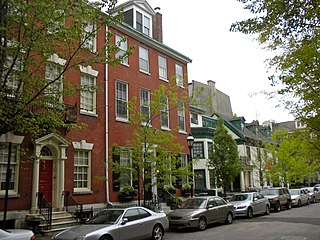
Washington Square West is a neighborhood in Center City, Philadelphia, Pennsylvania, United States. The neighborhood roughly corresponds to the area between 7th and Broad Streets and between Chestnut and South Streets, bordering on the Independence Mall tourist area directly northeast, Market East to the north, Old City and Society Hill to the East, Bella Vista directly south, Hawthorne to the southwest, and mid-town Philadelphia and Rittenhouse Square to the west. The area takes its name from Washington Square, a historic urban park in the northeastern corner of the neighborhood. In addition to being a desirable residential community, it is considered a hip, trendy neighborhood that offers a diverse array of shops, restaurants, and coffee houses. Washington Square West contains many gay-friendly establishments, especially in the gay village area of the neighborhood commonly known as the Gayborhood, which hosts annual events celebrating LGBT culture in Philadelphia, including OutFest.

West Philadelphia, nicknamed West Philly, is a section of the city of Philadelphia. Although there are no officially defined boundaries, it is generally considered to reach from the western shore of the Schuylkill River, to City Avenue to the northwest, Cobbs Creek to the southwest, and the SEPTA Media/Wawa Line to the south. An alternate definition includes all city land west of the Schuylkill; this would also include Southwest Philadelphia and its neighborhoods. The eastern side of West Philadelphia is also known as University City.
Fashion District Philadelphia is a shopping mall in Philadelphia, Pennsylvania, United States, located in Center City along Market Street. It opened in 2019 on the site of a previous mall known as The Gallery and later renamed The Gallery at Market East.

Center City includes the central business district and central neighborhoods of Philadelphia, Pennsylvania, United States. It comprises the area that made up the City of Philadelphia prior to the Act of Consolidation, 1854, which extended the city borders to be coterminous with Philadelphia County.

Kensington is a neighborhood in Philadelphia that belongs to Lower Northeast. As with all neighborhoods in the city, the lack of any official designation means the boundaries of the area vary between sources over time and are disputed among locals. Kensington, as most long-term residents view it, refers generally to the area consisting of Kensington, East Kensington, West Kensington, and Harrowgate. The adjacent Fairhill and Norris Square neighborhoods are more separate but may be included in Kensington; Fishtown and South (Olde) Kensington were historically included. The most conservative boundaries of the neighborhood, shown in the map below, are Front Street and 5th Street to the west, the Amtrak train tracks to the North, Trenton Avenue, the Trenton Avenue train tracks, and Frankford Avenue to the east, and Cecil B. Moore Avenue to the south.

Comcast Center, also known as the Comcast Tower, is a skyscraper at 1701 John F. Kennedy Boulevard in Center City Philadelphia. The 58-story, 297-meter (974 ft) tower is the second-tallest building in Philadelphia and in the U.S. state of Pennsylvania, and the 31st-tallest building in the United States. Originally called One Pennsylvania Plaza when plans for the building were announced in 2001, the Comcast Center went through two redesigns before construction began in 2005. Comcast Center was designed by Robert A.M. Stern Architects for Liberty Property Trust.

Mount Airy is a neighborhood of Northwest Philadelphia in the U.S. state of Pennsylvania.

Avenue of the Arts is a city-designated arts cultural district on a segment of Broad Street in Philadelphia, Pennsylvania, United States that includes many of the city's cultural institutions, most notably the theater district south of City Hall. The designation can be found as far south as Washington Avenue and as far north as the Cecil B. Moore neighborhood.

East Falls is a neighborhood in Lower Northwest, Philadelphia, Pennsylvania, United States. It lies on the east bank of the "Falls of the Schuylkill," cataracts submerged in 1822 by the Schuylkill Canal and Fairmount Water Works projects. East Falls sits next to the Germantown, Roxborough, Allegheny West, and the Nicetown-Tioga neighborhoods. Wissahickon Valley Park separates it from Manayunk, Philadelphia.

Grays Ferry, also known as Gray's Ferry, is a neighborhood in South Philadelphia, Pennsylvania, United States, bounded (roughly) by 25th Street on the east, the Schuylkill River on the west, Vare Avenue on the south, and Grays Ferry Avenue on the north. The section of this neighborhood west of 34th Street is also known as Forgotten Bottom.

Pennsylvania Route 3 is a 24.3-mile (39.1 km) state highway located in the southeastern portion of Pennsylvania. The route runs from U.S. Route 322 Business in West Chester east to PA 611 in Philadelphia.

Market Street, originally known as High Street, is a major east–west highway and street in Philadelphia, Pennsylvania, United States. The street is signed as Pennsylvania Route 3 between 38th Street and 15th Street. A short portion of the road continues west from Cobbs Creek Parkway to Delaware County, adjacent to Philadelphia. The street also serves as the dividing line for the "north" and "south" sides of the city. All north-south addresses in the city start at zero at Market Street.

Pennsylvania Route 291 is an east–west state route in Pennsylvania that runs from U.S. Route 13 and US 13 Business in Trainer, Delaware County, east to Interstate 76 (I-76) in South Philadelphia near the Walt Whitman Bridge and the South Philadelphia Sports Complex. Except for a short 1-mile (1.6 km) section between the western terminus and the Chester/Trainer line, PA 291 is mostly a four-lane highway. From the western terminus to the eastern part of Chester, the route has a concurrency with US 13. It runs parallel to the Delaware River for much of the route. The route passes through industrial areas near the river in Delaware County, serving Chester, Eddystone, Essington, and Lester. PA 291 enters Philadelphia near the Philadelphia International Airport, at which point it has an interchange with I-95. The route crosses the Schuylkill River on the George C. Platt Memorial Bridge and continues along Penrose Avenue to I-76. It has been designated the Industrial Heritage Highway.
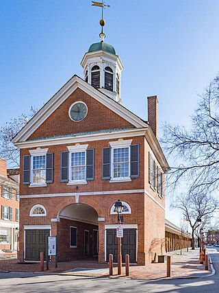
New Market, as it was originally known, and later also known as Head HouseMarket and Second Street Market, is an historic street market which is located on South 2nd Street between Pine and Lombard Streets in the Society Hill neighborhood of Philadelphia, Pennsylvania. With a history dating to 1745, it is one of the oldest surviving market buildings of its type in the nation.


