Olney-Oak Lane, Philadelphia

Last updated
Olney-Oak Lane
Fernrockrail.jpg
NPhilaDistrict.PNG
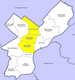
Map of Philadelphia, with Olney-Oak Lane at top of highlighted area (click for larger image)
CountryFlag of the United States.svg  United States of America
StateFlag of Pennsylvania.svg  Pennsylvania
County Flag of Philadelphia, Pennsylvania.svg Philadelphia
CityFlag of Philadelphia, Pennsylvania.svg Philadelphia
Population
 (2010)
  Total168,770
ZIP code
  • 19120
  • 19126
  • 19138
  • 19141
  • 19150

Olney-Oak Lane, Philadelphia, is a section of Philadelphia that is immediately north of North Philadelphia and south of Cheltenham. It is an area that consists of the now defunct township that was called "Bristol Township, Philadelphia County, Pennsylvania". The section is often excluded as part of North Philadelphia by city government agencies, [1] though locally it is often referred to as "Uptown,"[ citation needed ] along with the GermantownChestnut Hill area.

Contents

The section includes the neighborhoods of East Oak Lane and West Oak Lane, Feltonville, Fern Rock, Koreatown, Logan, Ogontz, Cedarbrook and Olney.

Demographics

As of 2010, the Olney-Oak Lane section of Philadelphia had a population of 168,770, with 76,576 males, 92,195 females and a median age of 33. [2]

Racial demographics: [3] [4]

See also

Related Research Articles

<span class="mw-page-title-main">Montgomery County, Pennsylvania</span> County in Pennsylvania, United States

Montgomery County, colloquially referred to as Montco, is a county in the Commonwealth of Pennsylvania. As of the 2020 census, the population of the county was 856,553, making it the third-most populous county in Pennsylvania after Philadelphia and Allegheny counties.

<span class="mw-page-title-main">Philadelphia County, Pennsylvania</span> County in Pennsylvania, United States

Philadelphia County is the most populous county in Pennsylvania and the 24th-most populous county in the nation. As of the 2020 census, the county had a population of 1,603,797. Its county seat is Philadelphia, the nation's sixth-largest city.

<span class="mw-page-title-main">Bucks County, Pennsylvania</span> County in Pennsylvania, United States

Bucks County is a county in the Commonwealth of Pennsylvania. As of the 2020 census, the population was 646,538, making it the fourth-most populous county in Pennsylvania. Its county seat is Doylestown. The county is named after the English county of Buckinghamshire.

<span class="mw-page-title-main">Leesport, Pennsylvania</span> Borough in Pennsylvania, United States

Leesport is a borough in Berks County, Pennsylvania, United States. The population was 1,918 at the 2010 census.

<span class="mw-page-title-main">Bristol Township, Pennsylvania</span> Township in Pennsylvania, United States

Bristol Township is a township in Bucks County, Pennsylvania, United States. The population was 54,582 at the 2010 census, making it the 13th largest municipality in the state. Bristol Township, along with Bristol Borough, is a cultural hub for Lower Bucks County, hosting celebrations of African and Latino heritage. Parts of the township consist of the neighborhoods of Fairless Hills and Levittown. It is located within the Delaware Valley.

<span class="mw-page-title-main">Levittown, Pennsylvania</span> Census-designated place and planned community in Pennsylvania, US

Levittown is a census-designated place (CDP) and planned community in Bucks County, Pennsylvania, United States. It is part of the Philadelphia metropolitan area. The population was 52,699 at the 2020 census, down from 52,983 at the 2010 census.

<span class="mw-page-title-main">Warminster Heights, Pennsylvania</span> Census-designated place in Pennsylvania, United States

Warminster Heights is a census-designated place and part of Warminster Township in Bucks County, Pennsylvania, United States. It is located near the eastern border of Hatboro in Montgomery County. The population was 4,124 at the 2010 census.

<span class="mw-page-title-main">Warrington Township, Bucks County, Pennsylvania</span> Township in Pennsylvania, United States

Warrington Township is a township in Bucks County, Pennsylvania, United States. Warrington Township is a northern suburb of Philadelphia. The population was 25,639 at the 2020 census.

<span class="mw-page-title-main">Croyle Township, Cambria County, Pennsylvania</span> Township in Pennsylvania, United States

Croyle Township is a township in Cambria County, Pennsylvania, United States. It is part of the Johnstown, Pennsylvania Metropolitan Statistical Area. The population was 2,339 at the 2010 census.

<span class="mw-page-title-main">Uwchlan Township, Pennsylvania</span> Township in Pennsylvania, United States

Uwchlan Township is a township in Chester County, Pennsylvania, United States. The population was 19,161 at the 2020 census.

<span class="mw-page-title-main">Jenkintown, Pennsylvania</span> Borough in Pennsylvania, United States

Jenkintown is a borough in Montgomery County, Pennsylvania. It is approximately 10 miles (16 km) north of Center City Philadelphia.

<span class="mw-page-title-main">Upper Providence Township, Montgomery County, Pennsylvania</span> Township in Pennsylvania, United States

Upper Providence Township is a township in Montgomery County, Pennsylvania, United States. As of the 2010 census, the township population was 21,219.

<span class="mw-page-title-main">Willow Grove, Pennsylvania</span> Census-designated place in Pennsylvania, United States

Willow Grove is a census-designated place (CDP) in Montgomery County, Pennsylvania, United States. A community in Philadelphia's northern suburbs, the population was 13,730 at the 2020 census. It is located in Upper Dublin Township, Abington Township and Upper Moreland Township. Willow Grove was once known for Willow Grove Park, an amusement park that was open from 1896 to 1976, now the site of Willow Grove Park Mall. Willow Grove is considered an edge city of Philadelphia, with large amounts of retail and office space.

<span class="mw-page-title-main">Wyncote, Pennsylvania</span> Place in Pennsylvania, United States

Wyncote is a census-designated place (CDP) in Cheltenham Township, Montgomery County, Pennsylvania, United States. It borders the northwestern and northeastern section of Philadelphia. Wyncote is located 11 miles from Center City Philadelphia at the southeasternmost tip of Montgomery County. The Jenkintown-Wyncote SEPTA station is the fifth busiest regional rail station in the SEPTA system.

<span class="mw-page-title-main">Berwyn, Pennsylvania</span> Census-designated place in Pennsylvania, United States

Berwyn is a census-designated place (CDP) in Chester County, Pennsylvania, United States. Berwyn is located within Tredyffrin and Easttown Townships. The area is part of the Philadelphia Main Line suburbs.

<span class="mw-page-title-main">North Philadelphia</span> Neighborhood of Philadelphia in Philadelphia, Pennsylvania

North Philadelphia, nicknamed North Philly, is a section of Philadelphia, Pennsylvania. It is immediately north of Center City. Though the full extent of the region is somewhat vague, "North Philadelphia" is regarded as everything north of either Vine Street or Spring Garden Street, between Northwest Philadelphia and Northeast Philadelphia. It is bordered to the north by Olney Ave along Broad Street, Spring Garden Street to the south, 35th Street to the west and Adams Avenue to the east. The Philadelphia Police Department patrols five districts located within North Philadelphia: the 22nd, 25th, 26th, 35th and 39th districts. There are thirteen ZIP codes for North Philadelphia: 19120, 19121, 19122, 19123, 19125, 19126, 19130, 19132, 19133, 19134, 19137, 19140 and 19141.

Bristol Township was a township that was located in Philadelphia County, Pennsylvania, United States. The township ceased to exist and was incorporated into the City of Philadelphia following the passage of the Act of Consolidation, 1854. It is the modern day Olney-Oak Lane Planning Analysis Section, though with a slight difference in the southern border. It is in present-day North Philadelphia, although Olney-Oak Lane is sometimes considered to be separate from North Philadelphia entirely because of their unique architecture, culture and differing patterns of development.

<span class="mw-page-title-main">Philadelphia Koreatown</span> Neighborhood of Pennsylvania, United States

The first Philadelphia Koreatown is located around the Olney section of the city of Philadelphia, United States. Since the late 1980s, the Korean community has expanded northward, and it now straddles the border between North Philadelphia in Philadelphia proper and the northern suburb of Cheltenham, although many Korean-American businesses and organizations and some residents remain in Olney and adjoining neighborhoods. Upper Darby Township, bordering West Philadelphia, also has a large Korean-American population; meanwhile, a rapidly growing Korean population and commercial presence has emerged in suburban Cherry Hill, New Jersey since 2010, centered along Marlton Pike, attracted to the Cherry Hill Public Schools. Signage in Hangul is ubiquitous in some neighborhoods in these areas.

<span class="mw-page-title-main">Cheltenham Township, Montgomery County, Pennsylvania</span> Place in Pennsylvania, United States

Cheltenham Township is a Home Rule Municipality and Township of the First Class located in the southeast corner of Montgomery County, Pennsylvania, United States. It borders the City of Philadelphia to the south and east, Abington Township and the borough of Jenkintown to the north, and Springfield Township to the west.

References

  1. "OpenDataPhilly - Planning Analysis Sections". Archived from the original on 2014-10-27. Retrieved 2014-10-27.
  2. "Olney - Oak Lane, Philadelphia, PA".
  3. "Factfinder at census.gov". Archived from the original on 2020-02-12. Retrieved 2013-10-14.
  4. "2010 Census". Medgar Evers College. Archived from the original on 2010-06-11. Retrieved 2010-04-13.

40°02′51″N75°06′02″W / 40.04759°N 75.10065°W / 40.04759; -75.10065