Haddington, Philadelphia

Last updated

Haddington Historic District
Haddington HD 61st St Philly.JPG
Street map of Philadelphia and surrounding area.png
Red pog.svg
USA Pennsylvania location map.svg
Red pog.svg
Usa edcp location map.svg
Red pog.svg
Location6000 blocks of Market, Ludlow and Chestnut Sts., Philadelphia, Pennsylvania
Coordinates 39°57′41″N75°14′31″W / 39.96139°N 75.24194°W / 39.96139; -75.24194
Area8 acres (3.2 ha)
ArchitectE. Allen Wilson et al.
Architectural styleColonial Revival, Classical Revival, Mission/Spanish Revival
NRHP reference No. 88001832 [1]
Added to NRHPSeptember 29, 1988

Haddington is a neighborhood in the West Philadelphia section of Philadelphia, Pennsylvania, United States. Its borders are defined as Haverford Avenue/Girard Avenue to the north, 52nd Street to the east, Market Street to the south, and 67th Street to the westernmost edge of the neighborhood.

Contents

History and architectural features

It is a largely African American community of mostly two-story rowhouses with a large proportion of elderly residents and a high home-ownership rate. Near the intersection of Vine Street and 56th Street, new construction and community facilities were built in the 1970s thanks to the Haddington Leadership Organization.

Haddington's Historic District is located on the 6000 blocks of Market, Ludlow, and Chestnut Streets, showcasing colonial and classical revival styles of architecture built from 1909 to 1915. It was listed on the National Register of Historic Places in 1998.

Also listed on the National Register of Historic Places are the George L. Brooks School and Thomas Dunlap School. [1]

Education

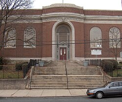
Haddington Branch Phila FLP Haddington01.jpg
Haddington Branch

The School District of Philadelphia operates public schools.

The Free Library of Philadelphia Haddington Branch serves Haddington. [2]

Related Research Articles

<span class="mw-page-title-main">Powelton Village, Philadelphia</span> United States historic place

Powelton Village is a neighborhood of mostly Victorian, mostly twin homes in the West Philadelphia section of Philadelphia, Pennsylvania. It is a national historic district that is part of University City. Powelton Village extends north from Market Street to Spring Garden Street, east to 32nd Street, west to 40th and Spring Garden Streets, and to 44th and Market Streets.

<span class="mw-page-title-main">Wynnefield, Philadelphia</span> Neighborhood of Philadelphia in Philadelphia County, Pennsylvania, United States

Wynnefield is a diverse middle-class neighborhood in West Philadelphia. Its borders are 53rd Street at Jefferson to the south, Philadelphia's Fairmount Park to the east, City Avenue to the north and the Amtrak Philadelphia Main Line tracks to the west.

<span class="mw-page-title-main">Northern Liberties, Philadelphia</span> Former District in Pennsylvania, United States

Northern Liberties is a neighborhood in Philadelphia, Pennsylvania, United States. Prior to its incorporation into Philadelphia in 1854, it was among the top 10 largest cities in the U.S. in every census from 1790 to 1850.

<span class="mw-page-title-main">Overbrook, Philadelphia</span> Neighborhood of Philadelphia in Philadelphia County, Pennsylvania, United States

Overbrook is an historic neighborhood that is located in the Commonwealth of Pennsylvania, United States. It is situated northwest of West Philadelphia, Philadelphia.

<span class="mw-page-title-main">Olney, Philadelphia</span> Neighborhood of Philadelphia in Pennsylvania, United States

Olney is a neighborhood in North Philadelphia, Pennsylvania, United States. It is roughly bounded by Roosevelt Boulevard to the south, Tacony Creek to the east, Godfrey Avenue to the north, and the railroad right-of-way west of Seventh Street to the west.

<span class="mw-page-title-main">Ogontz, Philadelphia</span> Neighborhood of Philadelphia in Pennsylvania, United States

Ogontz/Belfield is a neighborhood in Upper Northern Philadelphia that is located adjacent to West Oak Lane, East Germantown, Logan, and Fern Rock, Philadelphia, Pennsylvania, United States.

<span class="mw-page-title-main">West Kensington, Philadelphia</span> Neighborhood of Philadelphia in Pennsylvania, United States

West Kensington is a neighborhood in the North Philadelphia section of Philadelphia, Pennsylvania, United States. It is north of Olde Kensington. The Market Frankford El above Front Street forms the line between West Kensington and Kensington. Its bordering neighborhoods are Kensington to the east, Hartranft to the west, and Olde Kensington to the south. It is bounded by Front Street to the east, 6th Street to the west, Cecil B. Moore Avenue to the South and Lehigh Avenue to the north. It falls into the 19122 and 19133 ZIP Codes.

<span class="mw-page-title-main">Cobbs Creek, Philadelphia</span> Historic house in Pennsylvania, United States

Cobbs Creek is a neighborhood located in the West Philadelphia section of Philadelphia, Pennsylvania, United States, named for the creek which forms part of Philadelphia's western border. Cobbs Creek is generally bounded by Market Street to the north, Baltimore Avenue to the south, 52nd Street to the east, and the border of Upper Darby along Cobbs Creek to the West.

<span class="mw-page-title-main">Point Breeze, Philadelphia</span> Neighborhood of Philadelphia in Pennsylvania, United States

Point Breeze is a multicultural neighborhood in South Philadelphia in Philadelphia, Pennsylvania, United States. It is bounded by 25th Street to the west, Washington Avenue to the north, 18th Street to the east, and Moore Street to the south. Graduate Hospital lies to its north, and Newbold lies to its east. Point Breeze is separated from Grays Ferry to the west by a CSX railway viaduct over 25th Street.

<span class="mw-page-title-main">Hartranft, Philadelphia</span> Neighborhood of Philadelphia, Pennsylvania, US

Hartranft is a neighborhood in the central part of North Philadelphia section of Philadelphia, Pennsylvania, United States.

<span class="mw-page-title-main">Girard Estate, Philadelphia</span> Neighborhood of Philadelphia in Pennsylvania, United States

Girard Estate, also known as Girard Estates, is part of South Philadelphia, Pennsylvania, United States. Its boundaries stretch from South 22nd Street on the west to South 17th Street on the east. The southern boundary is clearly defined as the south side of Shunk Street, but its northern boundary is irregular in stretching from the north side of Porter Street between South 17th Street and South 21st Streets, along the east side of South 21st Street to West Passyunk Avenue, then along the south side of West Passyunk Avenue to its northwestern tip at South 22nd Street. It is named after Stephen Girard, whose South Philadelphia property was developed in the 1920s by the City of Philadelphia.

<span class="mw-page-title-main">Overbrook Farms, Philadelphia</span> United States historic place

Overbrook Farms is a neighborhood that is situated on the western edge of the West Philadelphia section of Philadelphia, Pennsylvania, United States. It is roughly bounded by City Avenue, 58th Street, Woodbine Avenue, and 66th Street at Morris Park.

<span class="mw-page-title-main">Spruce Hill, Philadelphia</span> Neighborhood of Philadelphia in Pennsylvania, United States

Spruce Hill is a neighborhood in the University City section of West Philadelphia, Pennsylvania, United States. It is situated between 40th and 46th streets and stretches from Market Street south to Woodland Avenue.

<span class="mw-page-title-main">Hawthorne, Philadelphia</span> Neighborhood of Philadelphia in Pennsylvania, United States

Hawthorne is a neighborhood in the South Philadelphia section of Philadelphia, Pennsylvania, United States. It is located between Broad Street and 11th Street, and extends from South Street to Washington Avenue.

<span class="mw-page-title-main">Dunlap, Philadelphia</span> Neighborhood of Philadelphia in Pennsylvania, United States

Dunlap is a small neighborhood in the West Philadelphia section of Philadelphia, Pennsylvania, United States. The neighborhood lies between Haverford Avenue and Market Street and stretches from 46th to 52nd streets. Dunlap is squeezed between the neighborhoods of Mill Creek and Haddington and situated just north of Walnut Hill. The neighborhood is named after the former historic Thomas Dunlap School that was restored into senior homes in 1991. Dunlap is located in the 19139 ZIP Code, and is situated in the Philadelphia Police Department's 19th police district, which encompasses a large portion of West Philadelphia.

<span class="mw-page-title-main">Pennsport, Philadelphia</span> Neighborhood of Philadelphia in Pennsylvania, United States

Pennsport is a neighborhood in the South Philadelphia section of Philadelphia, Pennsylvania, United States.

<span class="mw-page-title-main">Castor Gardens, Philadelphia</span> Neighborhood of Northeast Philadelphia

Castor Gardens is a neighborhood in the lower Northeast section of Philadelphia, Pennsylvania, United States. Castor Gardens' borders are not clearly defined, but it exists in the vicinity of Castor Avenue and Cottman Avenue. It is also near Roosevelt Boulevard. The neighborhood can either be entered from the south, by taking the Oxford Circle exit of Roosevelt Boulevard, or from the north, by taking the Cottman Avenue exit. Adjacent neighborhoods are Mayfair, Lawndale, Burholme, Oxford Circle, and Rhawnhurst.

<span class="mw-page-title-main">Spring Garden, Philadelphia</span> Historic neighborhood in Pennsylvania, United States

Spring Garden is a neighborhood in central Philadelphia, Pennsylvania, United States, bordering Center City on the north. Spring Garden is a neighborhood that combines diverse residential neighborhoods and significant cultural attractions. The residential areas on the north side of the neighborhood are composed mostly of brick and brownstone three-story townhouses built during the mid-to-late 19th century. The houses include townhouses in the Italianate style, Second Empire, Queen Anne, and Venetian Gothic. Many streets include "terraced" set ups, which include a small gardened plot, often raised, in front of the house. The residential areas to the south are dominated by taller, multi-family buildings built during the 20th century. The museum area, also to the south of Spring Garden Street, includes the Rodin Museum, the Central Library of Philadelphia, and the Barnes Museum. Before consolidation of Philadelphia, Spring Garden was a district of Philadelphia County.

<span class="mw-page-title-main">Whitman, Philadelphia</span> Neighborhood of Philadelphia, Pennsylvania

Whitman is a neighborhood in the South Philadelphia section of Philadelphia, Pennsylvania, United States. It is bounded on the west by Sixth Street, on the east by Front Street, on the south by Bigler Street, and on the north by Snyder Avenue. The name "Whitman" was adopted when the nearby Walt Whitman Bridge was being constructed in the 1950s. In 2015, Whitman and nearby South Philadelphia neighborhoods were named by Philadelphia Magazine as one of the safest and most family-friendly neighborhoods in Philadelphia.

<span class="mw-page-title-main">Carroll Park, Philadelphia</span> Neighborhood of Philadelphia in Pennsylvania, United States

Carroll Park is a neighborhood in West Philadelphia, Pennsylvania, United States. Its boundaries are Lansdowne Avenue to the north, West Girard Avenue to the south, North 63rd Street to the west, and North 52nd Street to the east. Along major streets of the neighborhood, the Carroll Park Community Council, Inc. has placed banners that say “Carroll Park: Where our neighbors become friends.” The 10 trolley runs along Lansdowne Avenue and the 15 trolley runs along Girard Avenue. There is a park by the name of Carroll Park between North 59th and North 58th Streets and West Thompson Street and West Girard Avenue. Carroll Park’s residents are primarily working-class and lower-income African-Americans.

References

  1. 1 2 "National Register Information System". National Register of Historic Places . National Park Service. March 13, 2009.
  2. "Haddington Branch." Free Library of Philadelphia. Retrieved on October 19, 2012.