
Philadelphia County is the most populous county in Pennsylvania and the 24th-most populous county in the nation. As of the 2020 census, the county had a population of 1,603,797. Its county seat is Philadelphia, the nation's sixth-largest city.

Lenapehoking is widely translated as 'homelands of the Lenape', which in the 16th and 17th centuries, ranged along the Eastern seaboard from western Connecticut to Delaware, and encompassed the territory adjacent to the Delaware and lower Hudson river valleys, and the territory between them.

Roxborough is a neighborhood in the Northwest section of the city of Philadelphia, Pennsylvania, United States. It is bordered to the southwest, along the Schuylkill River, by the neighborhood of Manayunk, along the northeast by the Wissahickon Creek section of Fairmount Park, and to the southeast by the neighborhood of East Falls. Beyond Roxborough to the northwest is Montgomery County. Roxborough's ZIP code is 19128. Most of Roxborough is in Philadelphia's 21st Ward.
Kingsessing is a neighborhood in the Southwest section of Philadelphia, Pennsylvania, United States. On the west side of the Schuylkill River, it is next to the neighborhoods of Cedar Park, Southwest Schuylkill, and Mount Moriah, as well as the borough of Yeadon in Delaware County. It is roughly bounded by 53rd Street to the northeast, Baltimore Avenue to the northwest, Cobbs Creek and 60th Street to the southwest, and Woodland Avenue to the southeast.

Cobbs Creek is an 11.8-mile-long (19.0 km) tributary of Darby Creek in Delaware County, Pennsylvania, in the United States. It forms an approximate border between Montgomery County and Delaware County. After Cobbs Creek passes underneath Township Line Road, it forms the border between Philadelphia County and Delaware County. It runs directly through the two sides of Mount Moriah Cemetery which spans the border of Southwest Philadelphia and Yeadon, Pennsylvania. It later joins Darby Creek before flowing into the Delaware River.
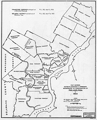
The Act of Consolidation, more formally known as the act of February 2, 1854, is legislation of the Pennsylvania General Assembly that created the consolidated City and County of Philadelphia, expanding the city's territory to the entirety of Philadelphia County and dissolving the other municipal authorities in the county. The law was enacted by the General Assembly and approved February 2, 1854, by Governor William Bigler. This act consolidated all remaining townships, districts, and boroughs within the County of Philadelphia, dissolving their governmental structures and bringing all municipal authority within the county under the auspices of the Philadelphia government. Additionally, any unincorporated areas were included in the consolidation. The consolidation was drafted to help combat lawlessness that the many local governments could not handle separately and to bring in much-needed tax revenue for the State.

Pennypack Creek is a 22.6-mile-long (36.4 km) creek in southeastern Pennsylvania in the United States. It runs southeast through lower Bucks County, eastern Montgomery County and the northeast section of Philadelphia, before emptying into the Delaware River.

Southwark was originally the Southwark District, a colonial-era municipality in Philadelphia County, Pennsylvania, United States. Today, it is a neighborhood in the South Philadelphia section of Philadelphia, Pennsylvania. Because of its location south of the early Philadelphia, the name was adopted in allusion to the borough of Southwark in the county of London, England, just south of the city of London.

Moyamensing is an area of Philadelphia established as a Moyamensing Township during British colonial rule on the fast land of the Neck, lying between Passyunk and Wicaco. It was incorporated into Philadelphia County, Pennsylvania, United States and today encompasses several neighborhoods along the Moyamensing Avenue corridor in the South Philadelphia section of Philadelphia.
Belmont District is a defunct district that existed briefly in Philadelphia County, Pennsylvania, United States. The district was created on April 14, 1853 from northern Blockley Township ceased to exist and on February 2, 1854 the district was incorporated into the City of Philadelphia following the passage of the Act of Consolidation, 1854.

Blockley Township is a defunct township that was located in Philadelphia County, Pennsylvania, United States. Incorporated in 1704, the township was incorporated into the City of Philadelphia under the 1854 Act of Consolidation.
Delaware Township is a defunct township that was located in Philadelphia County, Pennsylvania, United States. The borough ceased to exist and was incorporated into the City of Philadelphia following the passage of the Act of Consolidation, 1854.

Oxford Township was a township in Philadelphia County, Pennsylvania, United States. The township ceased to exist and was incorporated into the City of Philadelphia following the passage of the Act of Consolidation, 1854.
West Philadelphia Borough, also known as West Philadelphia District, is a defunct borough that was located west of the Schuylkill River in Blockley Township, Philadelphia County, Pennsylvania, United States. The borough ceased to exist and was incorporated into the City of Philadelphia following the passage of the Act of Consolidation, 1854.
Whitehall Borough is a defunct borough that was located in Philadelphia County, Pennsylvania, United States. The borough ceased to exist when it was incorporated into the City of Philadelphia on the passage of the Act of Consolidation, 1854.

Southwest Philadelphia is a section of Philadelphia, Pennsylvania, United States. The section can be described as extending from the western side of the Schuylkill River to the city line, with the SEPTA. The northern border is defined by the Philadelphia City Planning Commission as east from the city line along Baltimore Avenue moving south along 51st Street to Springfield Ave. It follows the train tracks until 49th Street. From 49th and Kingsessing Ave the line moves east along Kingsessing Ave. The line then moves south along 46th St to Paschall Ave where it jogs to join Grays Ferry where the line runs to the Schuylkill River.

East Passyunk Crossing is a neighborhood in South Philadelphia, Pennsylvania, United States. Its location is considered to be from Tasker Street to Snyder Avenue and Broad Street to 6th Street.

Passyunk Square is a neighborhood in South Philadelphia bounded by Broad Street to the west, 6th Street to the east, Tasker Street to the south and Washington Avenue to the north. Passyunk Square is bordered by the Bella Vista, Hawthorne, Central South Philadelphia, Wharton, and Point Breeze neighborhoods. The neighborhood got its Lenape name from the 1800s Passyunk Township, Pennsylvania which named Passyunk Square Park, located between 12th, 13th, Reed and Wharton Streets. The park was eventually renamed Columbus Square Park, and subsequently the neighborhood became known as Columbus Square. Sue Montella, Geoff DiMasi, and a group of neighbors revived the Passyunk Square name when forming the Passyunk Square Civic Association in 2003. The area has come to be known as Little Saigon for its large Vietnamese American commercial and residential presence, with one of the largest Vietnamese populations on the east coast.

Dickinson Square West is a neighborhood in South Philadelphia, Pennsylvania, United States bordered by neighborhoods Queen Village to the north, Whitman to the south, Pennsport to the east and Passyunk Square and East Passyunk Crossing to the west. The neighborhood was previously referred to as "Dickinson Narrows", but was officially reestablished as "Dickinson Square West" in 2013 by the Registered Community Organization, Dickinson Square West Civic Association, located within its boundaries. In October, 2018, The Dickinson Square West Civic Association passed an amendment to expand the southern boundary from Mifflin Street to Snyder Ave

