Girard Estate, Philadelphia

Last updated
Girard Estate
Phila FLP Passyunk01.jpg
Donatucci Branch of the Free Library of Philadelphia
Street map of Philadelphia and surrounding area.png
Red pog.svg
Girard Estate
Coordinates: Coordinates: 39°55′11″N75°10′58″W / 39.9196°N 75.1828°W / 39.9196; -75.1828
CountryFlag of the United States.svg  United States
State Pennsylvania
County Philadelphia County
City Philadelphia
Area code(s) 215, 267, and 445
Girardestate.png

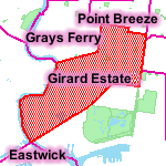
Girard Estate, also known as Girard Estates, is part of South Philadelphia. Its boundaries stretch from South 22nd Street on the west to South 17th Street on the east. The southern boundary is clearly defined as the south side of Shunk Street but its northern boundary is irregular in stretching from the north side of Porter Street between South 17th Street and South 21st Street, along east side of South 21st Street to West Passyunk Avenue, then along the south side of West Passyunk Avenue to its northwestern tip at South 22nd Street. It is named after Stephen Girard whose South Philadelphia property was developed in the 1920s by the City of Philadelphia.

Contents

History

Girard's country home was on a plot of land he named Gentilhommiere in what was formerly called Passyunk Township of Philadelphia County. He was likely the richest man in the United States when he died in 1831, and he left most of his $6 million estate to the City of Philadelphia.

Girard's will stated that the city must establish a school for poor orphaned white boys in his name, [1] and that Gentilhommiere must not be sold. To meet the second stipulation, the Board of City Trusts, trustee of the Girard Estate, developed 481 rental homes which became the Girard Estate homes.

Most of the semi-detached homes were designed by architects John and James H. Windrim, and were built from 1906 to 1916. The architectural styles included Bungalow, Prairie, Mission, Jacobean Revival and Colonial Revival. They are a marked difference from the typical South Philly row homes.

In 1950, the city received permission to sell all 481 homes to private owners. All the homes were sold within two years.

In 1979, Girard Estate became a location for "Rocky II." The crew filmed scenes on the 2300 block of S. Lambert Street for a week. In the film, the character Rocky Balboa bought 2313 S. Lambert St. with his winnings from the bout in the first film. (He even comments on the address, pointing out that the number "almost add up to nine!") All exteriors were shot on the street; house interiors were shot on a soundstage.

On March 15, 1981, Philadelphia organized crime boss Phillip Testa returned to his Girard Estates twin home at 2117 Porter Street and as he was opening the door a nail bomb exploded under his front porch killing him and doing extensive damage the house. [2]


The Philadelphia Quartermaster Depot and Edgar Allan Poe School are listed on the National Register of Historic Places. [3]

Education

The School District of Philadelphia operates public schools.

The Free Library of Philadelphia Thomas F. Donatucci, Sr. Branch (formerly the Passyunk Branch) serves Girard Estate. The library received its current name in 2004. [4]

Notable residents

Related Research Articles

Philip Testa American mobster

Philip Charles Testa, also known as "The Chicken Man", was an American mobster known for his brief leadership of the Philadelphia crime family. He became boss after Angelo Bruno was murdered by his own consigliere, Antonio Caponigro, who, in turn, was ordered killed by The Commission for acting without permission. Testa's nickname came from his involvement in a poultry business. About a year after Bruno's death, Testa was killed by the blast of a nail bomb allegedly ordered by his underboss, Peter Casella.

Fairmount, Philadelphia Neighborhood of Philadelphia in Philadelphia County, Pennsylvania, United States

Fairmount is a neighborhood within Lower North Philadelphia. Its boundaries are north of Fairmount Avenue, west of Corinthian Avenue, south of Girard Avenue and east of The Schuylkill River. While this may be the most accurate demarcation, the area's boundaries fluctuate depending how the neighborhood is defined. Several other neighborhoods near Fairmount are sometimes also collectively called Fairmount, including: Spring Garden, Franklintown and Francisville. Fairmount and neighboring Spring Garden are commonly referred to as the "Art Museum Area," for their proximity to and association with the Philadelphia Museum of Art. Fairmount is also the location of the Eastern State Penitentiary.

Northern Liberties, Philadelphia Former District in Pennsylvania, United States

Northern Liberties is a neighborhood in Philadelphia, Pennsylvania, United States. Prior to its incorporation into Philadelphia in 1854, it was among the top 10 largest cities in the U.S. in every census from 1790 to 1850.

South Philadelphia Neighborhood of Philadelphia, Pennsylvania

South Philadelphia, nicknamed South Philly, is the section of Philadelphia bounded by South Street to the north, the Delaware River to the east and south and the Schuylkill River to the west. A diverse community of many neighborhoods, South Philadelphia is well-known for its large Italian-American population, but it also contains large Asian American, Irish-American, African-American, and Latino populations.

Salvatore Testa American gangster (1956–1984)

Salvatore "Salvie" Testa, nicknamed "The Crowned Prince of the Philadelphia Mob", was an Italian-American mobster who served as a caporegime and later acting underboss for the Philadelphia crime family. Testa made his reputation as a hitman for the Philadelphia family during a period of internal gang conflict. The son of former boss Philip, Testa was an emerging figure in the mob until he was killed on the orders of boss Nicodemo Scarfo.

Point Breeze, Philadelphia Neighborhood of Philadelphia in Philadelphia County, Pennsylvania, United States

Point Breeze is a multicultural neighborhood in South Philadelphia in Philadelphia, Pennsylvania, United States. It is bounded by 25th Street to the west, Washington Avenue to the north, Broad Street to the east, and Mifflin Street to the south. Southwest Center City lies to its north, and Passyunk Square lies to its east. Point Breeze is separated from Grays Ferry to the west by a CSX railway viaduct over 25th Street.

Southwark, Philadelphia Former District in Pennsylvania, United States

Southwark was originally the Southwark District, a colonial-era municipality in Philadelphia County, Pennsylvania. Today, it is a neighborhood in the South Philadelphia section of Philadelphia, Pennsylvania. Because of its location south of the early Philadelphia, the name was adopted in allusion to the borough of Southwark in the county of London, England, just south of the city of London.

Pennsport, Philadelphia Neighborhood of Philadelphia in Philadelphia County, Pennsylvania, United States

Pennsport is a neighborhood in the South Philadelphia section of Philadelphia, Pennsylvania, United States.

Packer Park, Philadelphia Community area in Pennsylvania, United States

Packer Park is a neighborhood in the South Philadelphia section of Philadelphia, Pennsylvania, United States that originally included 1,000 homes built in two unique builder developments of Packer Park 1950s and Brinton Estates 1990s. It is now one of four residential communities to be designated as Packer Park. The original footprint community is also one of four adjacent communities that form Philadelphia's Sports Complex Special Services District. The approximate boundaries are Packer Avenue to the north, Hartranft Street to the south including FDR Park farther south, Broad Street to the east known as the Southern Parkway and I-76 to the far west. Packer Park has been considered home to one of the most organized community groups in the South Philadelphia region.

Stephen Girard Park

Stephen Girard Park is a 4-acre (16,000 m2) park in Philadelphia, Pennsylvania, in the South Philadelphia neighborhood of Girard Estate, bounded between West Shunk, West Porter, 21st, and 22nd Streets.

Whitman, Philadelphia Neighborhood of Philadelphia in Philadelphia County, Pennsylvania, United States

Whitman is a neighborhood in the South Philadelphia section of Philadelphia, Pennsylvania, United States. It is bounded on the west by Sixth Street, on the east by Front Street, on the south by Bigler Street, and on the north by Snyder Avenue. The name "Whitman" was adopted when the nearby Walt Whitman Bridge was being constructed in the 1950s. In 2015, Whitman and nearby South Philadelphia neighborhoods were named by Philadelphia Magazine as one of the safest and most family-friendly neighborhoods in Philadelphia.

Newbold is a neighborhood in South Philadelphia. Its boundaries are from Broad Street on the east to 18th Street on the west, Washington Avenue on the north to Wolf Street on the south.

East Passyunk Crossing, Philadelphia Neighborhood of Philadelphia in Philadelphia County, Pennsylvania, United States

East Passyunk Crossing is a South Philadelphia neighborhood. Its location is considered to be from Tasker Street to Snyder Avenue, Broad Street to 6th Street.

Passyunk Square, Philadelphia Neighborhood of Philadelphia in Philadelphia County, Pennsylvania, United States

Passyunk Square is a neighborhood in South Philadelphia bounded by Broad Street to the west, 6th Street to the east, Tasker Street to the south and Washington Avenue to the north. Passyunk Square is bordered by the Bella Vista, Hawthorne, Central South Philadelphia, Wharton and Point Breeze neighborhoods. The neighborhood got its Lenape name from the 1800s Passyunk Township, Pennsylvania which named Passyunk Square Park, located between 12th, 13th, Reed and Wharton Streets. The park was eventually renamed Columbus Square Park, and subsequently the neighborhood became known as Columbus Square. Sue Montella, Geoff DiMasi, and a group of neighbors revived the Passyunk Square name when forming the Passyunk Square Civic Association in 2003.

West Passyunk Neighborhood of Philadelphia in Philadelphia County, Pennsylvania, United States

West Passyunk is a neighborhood in South Philadelphia. It is bounded by Mifflin Street to the north, West Passyunk Avenue to the south, South 18th Street to east, and South 25th Street to the west. It is served by the 1st Police District, located at 24th and Wolf Streets.

Andrew Jackson School (Philadelphia) United States historic place

Fanny Jackson Coppin School, previously Federal Street School and then Andrew Jackson School, is a public K-8 school located in the Passyunk Square neighborhood of Philadelphia, Pennsylvania. It is a part of the School District of Philadelphia. The school was previously named for United States President Andrew Jackson before changing the name in 2021 to honor former Philadelphia teacher Fanny Jackson Coppin.

Dickinson Square West, Philadelphia Neighborhood of Philadelphia in Philadelphia County, Pennsylvania, United States

Dickinson Square West, Philadelphia is a neighborhood in South Philadelphia bordered by neighborhoods Queen Village to the north, Whitman to the south, Pennsport to the east and Passyunk Square and East Passyunk Crossing to the west. The neighborhood was previously referred to as "Dickinson Narrows", but was officially reestablished as "Dickinson Square West" in 2013 by the Registered Community Organization, Dickinson Square West Civic Association, located within its boundaries. In October, 2018, The Dickinson Square West Civic Association passed an amendment to expand the southern boundary from Mifflin Street to Snyder Ave

Girard Avenue Major commercial and residential street in Philadelphia, Pennsylvania, United States

Girard Avenue is a major commercial and residential street in Philadelphia, Pennsylvania. For most of its length it runs east–west, but at Frankford Avenue it makes a 135-degree turn north. Parts of the road are signed as U.S. Route 13 and U.S. Route 30.

References

  1. "School Desegregation and Civil Rights Stories: Girard College, Philadelphia, Pennsylvania". NARA . Retrieved 2007-12-08.
  2. Capuzzo, Michael "The Murder Room: The Heirs of Sherlock Holmes Gather to Solve the World's Most Perplexing Cold Cases" p. 189. New York: Gotham Books. 2010
  3. "National Register Information System". National Register of Historic Places . National Park Service. July 9, 2010.
  4. "Thomas F. Donatucci, Sr.." Free Library of Philadelphia. Retrieved on October 19, 2012.
  5. "Pat Martino Homepage".