Southwest Center City, Philadelphia

Last updated
Southwest Center City
Graduate Hospital
South of South
NavalSquare.jpg
Street map of Philadelphia and surrounding area.png
Red pog.svg
Southwest Center City
Graduate Hospital
South of South
Coordinates: 39°56′31″N75°10′30″W / 39.942°N 75.175°W / 39.942; -75.175
Country Flag of the United States.svg  United States of America
State Flag of Pennsylvania.svg  Pennsylvania
County Flag of Philadelphia, Pennsylvania.svg Philadelphia
City Flag of Philadelphia, Pennsylvania.svg Philadelphia
Area
  Total0.391 sq mi (1.01 km2)
Population
 (2010)
  Total14,919
  Density38,130/sq mi (14,720/km2)
ZIP Code
19146

Southwest Center City (SWCC), also known as Graduate Hospital, [1] is a neighborhood that is located in South Philadelphia, Pennsylvania, United States, bordering Center City Philadelphia. The neighborhood is bordered on the north by South Street, on the south by Washington Avenue, on the west by the Schuylkill River, and on the east by Broad Street. [2] [3] [4]

Contents

It is an area adjacent to the Fitler Square and Rittenhouse Square neighborhoods to the north and Point Breeze to the south, and is home to community service organizations, restaurants, churches, retail establishments, and some light industry.

Names

The neighborhood has many nicknames. The Philadelphia Planning Commission refers to it as Southwest Center City. [1] Since the 1980s, it has been often referred to as Graduate Hospital, after the medical facility on the northern edge of the neighborhood. This name has become merely historical in nature since the hospital closed in 2007. Despite this, it is still used and is sometimes shortened to G-Ho. [5] The area is also referred to as South of South [6] or So-So. [7] A small corner of this area is sometimes known as Devil's Pocket.

Composition

The neighborhood consists primarily of nineteenth and twentieth-century rowhouses interspersed with corner stores, 22 churches and a few larger architectural landmarks. On the eastern half of the neighborhood is the Scottish Rite affordable housing complex which consists of two multi-story apartment buildings that cater mostly to elderly and low income individuals. The former buildings of Graduate Hospital lie on South Street, the northern border of the neighborhood. Along Grays Ferry Avenue is the former Philadelphia Naval Asylum or Naval Home, designed in 1826 by William Strickland. This National Historic Landmark, first constructed in 1833, closed in 1976, and has been developed into condos is now known as Naval Square. [8] The Schuylkill Arsenal was originally built at the edge of this neighborhood, but has since been demolished.

History

Marian Anderson House on Martin Street M Anderson House Philly.jpg
Marian Anderson House on Martin Street

Prior to the Act of Consolidation, 1854, this neighborhood was part of Moyamensing Township. Moyamensing was originally chartered by the Dutch governor Alexander d'Hinoyossa, and in 1684, William Penn confirmed the title. [9]

The neighborhood began taking shape after the Civil War. In 1870, it was predominantly an Irish American community; however, the neighborhood was in a transitional period, and by 1920, a majority of its residents were African Americans. It continued to experience significant in-migration from the south prior to, during, and immediately after World War II. It remained a solid working-class neighborhood for most of the first half of the twentieth century.

In the 1960s a crosstown expressway running along South Street was planned. This would have created a barrier between Center City and the neighborhoods to the south. The result was widespread abandonment of properties in SWCC and the decay of the South Street business corridor. The loss of jobs and residents caused the neighborhood to decline as buildings were abandoned and left to deteriorate.

The Marian Anderson House, Franklin Hose Company No. 28, William S. Peirce School, Philadelphia, Wilmington and Baltimore Railroad Freight Shed, Royal Theater, St. Anthony de Padua Parish School, Edwin M. Stanton School, and Tindley Temple United Methodist Church are listed on the National Register of Historic Places. [10]

Recent development

In recent years, the area has experienced growth and gentrification. Hundreds of single family homes and condominium units have been built or refurbished. As a result of the neighborhood's proximity to Center City and increasing desirability, a variety of new businesses catering to the increasingly gentrified population have opened. Despite the improvements, the neighborhood still contains some abandoned and dilapidated housing, especially towards the south.

The Grammy Award winning musician and local resident Kenneth Gamble founded Universal Companies in Southwest Center City to revitalize the neighborhood. Universal Community Homes, a division of the company, began the Universal Court housing project in the neighborhood in the 1990s. Originally, some tension existed between the company and the local South of South Neighborhood Association, but this was soon resolved as the project was deemed a success. [11] Universal Companies has since opened several small neighborhood businesses, low-income housing, and a charter school.

Children's Hospital Expansion 2017

The Children's Hospital of Philadelphia is expanding in the western part of the neighborhood and opened its first facility in 2017 along the Schuykill River. It replaced the Springfield Beer Distributor and the former JFK Vocational Center (earlier the Marine Corps Depot of Supplies), which were demolished. [12] [13] The Philadelphia Inquirer states that the area will be undergoing gentrification to the point that the area may no longer be known by its current name "Devil's Pocket." [14] Furthermore, the area is expected to become a major contributor to Philadelphia's economy with the potential of $63 billion pumped into the economy as well as a job generator. The hospital has hired a consultant to plan the traffic patterns around the area as they did for Delaware Waterfront and New York's Battery Park. The plan is for "... three towers, of about 26 stories each, would be lined up along Schuylkill Avenue." The plans unveiled by the city show that Schuylkill Avenue is part of a six region area that also includes University City all the way to the Philadelphia International Airport that is part of a revitalization plan to stimulate the region. [15]

The proposal for three new Schuylkill Avenue towers proposed by the Children's Hospital of Philadelphia is for the towers to take the place of the Springfield Beer Distributor, and the former JFK Vocational School, with each tower being 26 stories high.

Culture

Every year since 1975, the area hosts Philadelphia's Odunde festival, a one-day festival and mostly a street market catered to African-American interests and the African diaspora. It is derived from the tradition of the Yoruba people of Nigeria, in celebration of the new year. It is centered at the intersection of Grays Ferry Avenue and South Street.

A local pub, Grace Tavern, was ranked first on Philadelphia Weekly 's list of the Top 50 Bars in 2008. [16]

Related Research Articles

<span class="mw-page-title-main">Children's Hospital of Philadelphia</span> Hospital in U.S., Delaware Valley

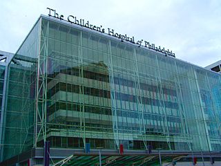
The Children's Hospital of Philadelphia, also known by its acronym CHOP, is a children's hospital in Philadelphia, Pennsylvania. Its primary campus is located in the University City neighborhood of West Philadelphia on the campus of the University of Pennsylvania. The hospital has 594 beds and more than one million outpatient and inpatient visits annually. It is one of the world's largest and oldest children's hospitals and the first hospital dedicated to the healthcare of children.

<span class="mw-page-title-main">Interstate 676</span> Highway in New Jersey and Pennsylvania

Interstate 676 (I-676) is an Interstate Highway that serves as a major thoroughfare through Center City Philadelphia, where it is known as the Vine Street Expressway, and Camden, New Jersey, where it is known as the northern segment of the North–South Freeway, as well as the Martin Luther King Jr. Memorial Highway in honor of civil rights leader Martin Luther King Jr. Its western terminus is at I-76 in Philadelphia near the Philadelphia Museum of Art and Fairmount Park. From there, it heads east and is then routed on surface streets near Franklin Square and Independence National Historical Park, home of the Liberty Bell, before crossing the Delaware River on the Benjamin Franklin Bridge. On the New Jersey side of the bridge, the highway heads south to its southern terminus at I-76 in Gloucester City near the Walt Whitman Bridge. Between the western terminus and downtown Camden, I-676 is concurrent with U.S. Route 30 (US 30).

<span class="mw-page-title-main">Transportation in Philadelphia</span>

Transportation in Philadelphia involves the various modes of transport within the city and its required infrastructure. In addition to facilitating intracity travel, Philadelphia's transportation system connects Philadelphia to towns of its metropolitan area and surrounding areas within the Northeast megalopolis.

<span class="mw-page-title-main">University City, Philadelphia</span> Neighborhood of Philadelphia in Philadelphia County, Pennsylvania, United States

University City is the easternmost portion of West Philadelphia, encompassing several Philadelphia universities. It is situated directly across the Schuylkill River from Center City.

<span class="mw-page-title-main">South Philadelphia</span> Neighborhood of Philadelphia, Pennsylvania

South Philadelphia, nicknamed South Philly, is the section of Philadelphia bounded by South Street to the north, the Delaware River to the east and south, and the Schuylkill River to the west. A diverse working-class community of many neighborhoods, South Philadelphia is well-known for its large Italian-American population, but it also contains large Asian American, Irish-American, African-American, and Latino populations.

<span class="mw-page-title-main">West Philadelphia</span> Neighborhood of Philadelphia, Pennsylvania

West Philadelphia, nicknamed West Philly, is a section of the city of Philadelphia. Although there are no officially defined boundaries, it is generally considered to reach from the western shore of the Schuylkill River, to City Avenue to the northwest, Cobbs Creek to the southwest, and the SEPTA Media/Wawa Line to the south. An alternate definition includes all city land west of the Schuylkill; this would also include Southwest Philadelphia and its neighborhoods. The eastern side of West Philadelphia is also known as University City.

<span class="mw-page-title-main">Schuylkill Expressway</span> Highway in Pennsylvania

The Schuylkill Expressway, locally known as "the Schuylkill", is a freeway through southern Montgomery County and the city of Philadelphia. It is the easternmost segment of Interstate 76 (I-76) in the U.S. state of Pennsylvania. It extends from the Valley Forge interchange of the Pennsylvania Turnpike in King of Prussia, paralleling its namesake Schuylkill River for most of the route, southeast to the Walt Whitman Bridge over the Delaware River in South Philadelphia. It serves as the primary corridor into Philadelphia from points west. Maintenance and planning for most of the highway are administered through Pennsylvania Department of Transportation (PennDOT) District 6, with the Delaware River Port Authority (DRPA) maintaining the approach to the Walt Whitman Bridge.

<span class="mw-page-title-main">Northwest Philadelphia</span> Neighborhood of Philadelphia in Philadelphia, Pennsylvania

Northwest Philadelphia is a section of the city of Philadelphia. The official boundary is Stenton Avenue to the north, the Schuylkill River to the southwest, Northwestern Avenue to the northwest, Roosevelt Boulevard to the south, and Wister Street and Stenton Avenue to the east. Conventionally, the area east of Wissahickon Creek, which comprises Germantown, Mount Airy, Chestnut Hill, and Cedarbrook, is termed the 'Upper Northwest', and the are west of the creek, which comprises Roxborough, Wissahickon, East Falls, and Manayunk, is termed the 'Lower Northwest'. The area of Philadelphia west of the Schuylkill River is known as West Philadelphia. The Philadelphia Police Department patrols two districts located within Northwest Philadelphia. The two patrol districts serving Northwest Philadelphia are the 5th and 14th districts.

<span class="mw-page-title-main">Point Breeze, Philadelphia</span> Neighborhood of Philadelphia in Pennsylvania, United States

Point Breeze is a multicultural neighborhood in South Philadelphia in Philadelphia, Pennsylvania, United States. It is bounded by 25th Street to the west, Washington Avenue to the north, 18th Street to the east, and Moore Street to the south. Graduate Hospital lies to its north, and Newbold lies to its east. Point Breeze is separated from Grays Ferry to the west by a CSX railway viaduct over 25th Street.

<span class="mw-page-title-main">Grays Ferry, Philadelphia</span> Neighborhood of Philadelphia in Pennsylvania, United States

Grays Ferry, also known as Gray's Ferry, is a neighborhood in South Philadelphia, Pennsylvania, United States, bounded (roughly) by 25th Street on the east, the Schuylkill River on the west, Vare Avenue on the south, and Grays Ferry Avenue on the north. The section of this neighborhood west of 34th Street is also known as Forgotten Bottom. Grays Ferry shares borders with Southwest Center City to the North, Point Breeze to the East, and Girard Estate to the South. Gray’s Ferry is across from where Mill Creek debouches at about 43rd street. Historically, Grays Ferry was one of the largest enclaves of Irish Americans in the city, and while there are still many Irish left, it is now home to a significant African American population.

<span class="mw-page-title-main">Broad Street (Philadelphia)</span> Thoroughfare in Pennsylvania

Broad Street is a major arterial street in Philadelphia, Pennsylvania. The street runs for approximately 13 miles (21 km), beginning at the intersection of Cheltenham Avenue on the border of Cheltenham Township and the West/East Oak Lane neighborhoods of North Philadelphia to the Philadelphia Navy Yard in South Philadelphia. It is Pennsylvania Route 611 along its entire length with the exception of its northernmost part between Old York Road and Pennsylvania Route 309 and the southernmost part south of Interstate 95.

<span class="mw-page-title-main">Southwest Philadelphia</span> Neighborhood of Philadelphia in Philadelphia, Pennsylvania

Southwest Philadelphia is a section of Philadelphia, Pennsylvania, United States. The section can be described as extending from the western side of the Schuylkill River to the city line, with the SEPTA. The northern border is defined by the Philadelphia City Planning Commission as east from the city line along Baltimore Avenue moving south along 51st Street to Springfield Ave. It follows the train tracks until 49th Street. From 49th and Kingsessing Ave the line moves east along Kingsessing Ave. The line then moves south along 46th St to Paschall Ave where it jogs to join Grays Ferry where the line runs to the Schuylkill River.

<span class="mw-page-title-main">Pennsylvania Route 291</span> State highway in Pennsylvania, US

Pennsylvania Route 291 is an east–west state route in Pennsylvania that runs from U.S. Route 13 and US 13 Business in Trainer, Delaware County, east to Interstate 76 (I-76) in South Philadelphia near the Walt Whitman Bridge and the South Philadelphia Sports Complex. Except for a short 1-mile (1.6 km) section between the western terminus and the Chester/Trainer line, PA 291 is mostly a four-lane highway. From the western terminus to the eastern part of Chester, the route has a concurrency with US 13. It runs parallel to the Delaware River for much of the route. The route passes through industrial areas near the river in Delaware County, serving Chester, Eddystone, Essington, and Lester. PA 291 enters Philadelphia near the Philadelphia International Airport, at which point it has an interchange with I-95. The route crosses the Schuylkill River on the George C. Platt Memorial Bridge and continues along Penrose Avenue to I-76. It has been designated the Industrial Heritage Highway.

<span class="mw-page-title-main">Pennsport, Philadelphia</span> Neighborhood of Philadelphia in Pennsylvania, United States

Pennsport is a neighborhood in the South Philadelphia section of Philadelphia, Pennsylvania, United States.

<span class="mw-page-title-main">Devil's Pocket, Philadelphia</span> Neighborhood of Philadelphia in Pennsylvania, United States

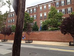
Devil's Pocket is a small neighborhood in the South Philadelphia section of Philadelphia, Pennsylvania, United States. The neighborhood, bordered by Christian and Taney streets, Grays Ferry Avenue, and the Naval Square development, consists of rowhouses tucked near an industrial landscape near the Schuylkill River. A historically Irish-American neighborhood, Devil’s Pocket has seen real estate development and gentrification in recent years, including a major expansion of the Children’s Hospital of Philadelphia.

<span class="mw-page-title-main">South Philadelphia Sports Complex</span> Sports venue in Philadelphia, Pennsylvania

The South Philadelphia Sports Complex is the home of four major Philadelphia professional sports teams. The complex is located in South Philadelphia and is the site of the Wells Fargo Center, home arena for the Philadelphia 76ers and Philadelphia Flyers, Lincoln Financial Field, home field for the Philadelphia Eagles, Citizens Bank Park, home field for the Philadelphia Phillies, and Xfinity Live!, a sports retail and entertainment center.

Gentrification is the controversial process of affluent people moving into a historically low-income neighborhood. It is often criticized because the current residents have limited options to buy or rent equivalent housing in alternative areas at the same price. If they stay, prices for products, services, and taxes rise and existing social networks are disturbed. Gentrification is the opposite of white flight—when residents voluntarily move away as a neighborhood declines.

<span class="mw-page-title-main">Lower Moyamensing, Philadelphia</span> Neighborhood of Philadelphia in Pennsylvania, United States

Lower Moyamensing is a neighborhood in South Philadelphia, Pennsylvania, United States, situated just south of the East Passyunk Crossing neighborhood and north of the stadium area. It is bounded by Snyder Avenue to the north, Oregon Avenue to the south, South 7th Street to the east, and South Broad Street to the west. The neighborhood was once part of Moyamensing Township before becoming part of Philadelphia in 1854. Lower Moyamensing is known for its 19th century row homes, factory buildings, and variety of restaurants. South Philadelphia High School is located in Lower Moyamensing, at the corner of Broad and Jackson Streets.

<span class="mw-page-title-main">Naval Square, Philadelphia</span> Neighborhood of Philadelphia in Philadelphia County, Pennsylvania, United States

Naval Square is a gated community within the Graduate Hospital neighborhood of Philadelphia that served as the first United States Naval Academy from 1834 to 1845, when the Naval Academy formed in Annapolis. It continued as a retirement home for sailors and marines and was called the Naval Home until 1976, when the facility was relocated to Mississippi.

References

  1. 1 2 Saffron, Inga (July 20, 2018). "Searching for a new identity: Graduate Hospital long gone, but the incongruous name lives on". The Philadelphia Inquirer . Retrieved September 12, 2021 via Newspapers.com.
  2. Map from UPenn study on the neighborhood
  3. Map of the Southwest Central Redevelopment Area as of 1968
  4. Heavens, Alan J. (December 19, 2008). "Philly's hot, new location". The Philadelphia Inquirer . Retrieved September 12, 2021 via Newspapers.com.
  5. City Paper article about "G-Ho"
  6. SOSNA - The South of South Neighborhood Association
  7. McCabe, Caitlin (July 23, 2017). "Naming your neighborhood". The Philadelphia Inquirer . Retrieved September 12, 2021 via Newspapers.com.
  8. Naval Square, a Toll Brothers development that will make up a large part of the neighborhood
  9. Early Moyamensing history from ushistory.com.
  10. "National Register Information System". National Register of Historic Places . National Park Service. July 9, 2010.
  11. Kromer, John, Neighborhood Recovery: Reinvestment Policy for the New Hometown p44, Rutgers University Press NJ, 2000. ISBN   0-8135-2716-3
  12. "CHOP - Schuylkill Avenue Community Meeting - Recap". South of South Neighborhood Association. Retrieved 16 March 2015.
  13. "Schuylkill Avenue Phase 1: Community Meeting 2/25/15" (PDF). Children's Hospital of Philadelphia. Archived from the original (PDF) on 2015-03-16. Retrieved 2015-03-16. Demolition Complete
  14. "CHOP expansion could bring jobs, traffic".
  15. "Planning to develop lower Schuylkill".
  16. "Philly's Top 50 Bars". Philadelphia Weekly . March 5, 2008. Archived from the original on April 20, 2014.