Lower North Philadelphia

Last updated
Lower North Philadelphia
Montgomery n 18th Philly.JPG
Lower North Philadelphia at Montgomery Avenue and 18th Street
NPhilaDistrict.PNG
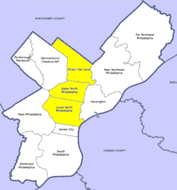
Map of Philadelphia County with North Philadelphia highlighted. Click for larger image
Country Flag of the United States.svg  United States of America
State Flag of Pennsylvania.svg  Pennsylvania
County Flag of Philadelphia, Pennsylvania.svg Philadelphia
City Flag of Philadelphia, Pennsylvania.svg Philadelphia
Area
  Total2.3 sq mi (6 km2)
Population
 (2010)
  Total59,250
  Density14,736/sq mi (5,690/km2)
ZIP code
19121, 19122, 19123, 19130, 19133

Lower North Philadelphia is a section of Philadelphia, Pennsylvania, that is immediately north of Center City and below Upper North Philadelphia and can be described as a section of Philadelphia that was designated as a "Model City" target, that has overcome poverty and blight through key developments and a recipient of a federal funded program in 1966 to improve the neighborhood and extend the Center City district north of City Hall. [1] It also contains the Lower North Philadelphia Speculative Housing Historic District along Cecil B. Moore Avenue.

Lower North Philadelphia consists of the Brewerytown, Cecil B. Moore, Cabot, Fairhill, Francisville, Hartranft, Ludlow, North Central, Poplar, Sharswood, Spring Garden, South Lehigh, Stanton, Strawberry Mansion, Yorktown, Fairmount and Northern Liberties neighborhoods.

Demographics

The demographics of Lower North Philadelphia shows that the area has a population density of 14,736 people per mile with an average household size of 3 and 30% of households had children. There is an 18% annual residential turnover rate with 42% of residents staying for more than 5 years, with an average of 5 years of residency. [2]

Related Research Articles

<span class="mw-page-title-main">Cecil County, Maryland</span> County in the United States

Cecil County is a county located in the U.S. state of Maryland at the northeastern corner of the state, bordering both Pennsylvania and Delaware. As of the 2020 census, the population was 103,725. The county seat is Elkton.

<span class="mw-page-title-main">North East, Maryland</span> Town in Maryland, United States

North East is a town in Cecil County, Maryland, United States. It is located between Philadelphia and Baltimore. The population was 3,572 at the 2010 census.

<span class="mw-page-title-main">Port Deposit, Maryland</span> Historic district in Maryland, United States

Port Deposit is a town in Cecil County, Maryland, United States. It is located on the east bank of the Susquehanna River near its discharge into the Chesapeake Bay. The population was 653 at the 2010 census.

<span class="mw-page-title-main">Drexel Hill, Pennsylvania</span> Neighborhood in Delaware County, Pennsylvania, United States

Drexel Hill is a neighborhood and census-designated place (CDP) located in Upper Darby, Pennsylvania, United States. The population was 29,181 at the 2020 census, an increase over 28,043 in 2010, and accounting for over one-third of Upper Darby's population.

<span class="mw-page-title-main">Folsom, Pennsylvania</span> Census-designated place in Pennsylvania, United States

Folsom is a census-designated place (CDP) in Delaware County, Pennsylvania, United States. It is part of Ridley Township. The population was 8,323 at the 2010 census.

<span class="mw-page-title-main">Prospect Park, Pennsylvania</span> Borough in Pennsylvania, United States

Prospect Park is a borough in Delaware County, Pennsylvania, United States. The population was 6,454 at the 2010 census, down from 6,594 at the 2000 census. It originated as a bedroom community of Philadelphia. It is located within 10 miles (16 km) of Center City, Philadelphia, with convenient rail access.

<span class="mw-page-title-main">Yeadon, Pennsylvania</span> Borough in Pennsylvania, United States

Yeadon is a borough in Delaware County, Pennsylvania, United States. It borders the city of Philadelphia. The population was 11,443 at the 2010 census.

Penn Wynne is a census-designated place (CDP) in Montgomery County, Pennsylvania, United States. It is part of Lower Merion Township, and the mailing address is Wynnewood. The population was 5,697 at the 2010 census. It is mainly a residential area. The main arteries are Haverford Road and Manoa Road.

<span class="mw-page-title-main">Manhattan Community Board 1</span> Manhattan Community Board

The Manhattan Community Board 1 is a New York City community board encompassing the neighborhoods of Battery Park City, the Financial District, the South Street Seaport, and TriBeCa in Lower Manhattan in the borough of Manhattan as well as Liberty Island, Ellis Island and Governors Island. It is bounded by Baxter Street, Pearl Street, the Brooklyn Bridge and the East River on the east, Upper New York Bay on the south, the Hudson River on the west and Canal Street on the north.

<span class="mw-page-title-main">Kensington, Philadelphia</span> Neighborhood in Philadelphia, Pennsylvania

Kensington is a neighborhood in Philadelphia that belongs to Lower Northeast. As with all neighborhoods in the city, the lack of any official designation means the boundaries of the area vary between sources over time and are disputed among locals. Kensington, as most long-term residents view it, refers generally to the area consisting of Kensington, East Kensington, West Kensington, and Harrowgate. The adjacent Fairhill and Norris Square neighborhoods are more separate but may be included in Kensington; Fishtown and South (Olde) Kensington were historically included. The most conservative boundaries of the neighborhood, shown in the map below, are Front Street and 5th Street to the west, the Amtrak train tracks to the North, Trenton Avenue, the Trenton Avenue train tracks, and Frankford Avenue to the east, and Cecil B. Moore Avenue to the south.

<span class="mw-page-title-main">North Philadelphia</span> Neighborhood of Philadelphia in Philadelphia, Pennsylvania

North Philadelphia, nicknamed North Philly, is a section of Philadelphia, Pennsylvania. It is immediately north of Center City. Though the full extent of the region is somewhat vague, "North Philadelphia" is regarded as everything north of either Vine Street or Spring Garden Street, between Northwest Philadelphia and Northeast Philadelphia. It is bordered to the north by Cheltenham Township along Cheltenham Avenue, Spring Garden Street to the south, 35th Street to the west and Adams Avenue to the east. The Philadelphia Police Department patrols five districts located within North Philadelphia: the 22nd, 25th, 26th, 35th and 39th districts. There are fifteen ZIP codes for North Philadelphia: 19120, 19121, 19122, 19123, 19125, 19126, 19130, 19132, 19133, 19134, 19137, 19138, 19140, 19141, and 19150.

<span class="mw-page-title-main">Temple University station</span> SEPTA train station in Philadelphia, Pennsylvania, United States

Temple University station is an above-ground SEPTA Regional Rail station located at the eastern edge of the Temple University campus at 915 West Berks Street between 9th and 10th Streets, in the Cecil B. Moore section of Lower North Philadelphia, Pennsylvania. The station is in the Center City fare zone, although the station itself is located in North Philadelphia.

<span class="mw-page-title-main">West Oak Lane, Philadelphia</span> Neighborhood of Philadelphia in Pennsylvania, United States

West Oak Lane is a neighborhood in the Northwest Philadelphia, Pennsylvania, United States. The neighborhood was developed primarily between the early 1920s and late 1930s, with the areas near to Cedarbrook constructed after World War II. At the northeast corner of Limekiln Pike and Washington Lane was the site of the Cedar Park Inn, a historic tavern built in the early 19th century, which was torn down sometime after 1931 as the neighborhood was being fully developed.

<span class="mw-page-title-main">Northwest Philadelphia</span> Neighborhood of Philadelphia in Philadelphia, Pennsylvania

Northwest Philadelphia is a section of the city of Philadelphia. The official boundary is Stenton Avenue to the north, the Schuylkill River to the southwest, Northwestern Avenue to the northwest, Roosevelt Boulevard to the south, and Wister Street and Stenton Avenue to the east. Conventionally, the area east of Wissahickon Creek, which comprises Germantown, Mount Airy, Chestnut Hill, and Cedarbrook, is termed the 'Upper Northwest', and the are west of the creek, which comprises Roxborough, Wissahickon, East Falls, and Manayunk, is termed the 'Lower Northwest'. The area of Philadelphia west of the Schuylkill River is known as West Philadelphia. The Philadelphia Police Department patrols two districts located within Northwest Philadelphia. The two patrol districts serving Northwest Philadelphia are the 5th and 14th districts.

<span class="mw-page-title-main">Cobbs Creek, Philadelphia</span> Historic house in Pennsylvania, United States

Cobbs Creek is a neighborhood located in the West Philadelphia section of Philadelphia, Pennsylvania, United States, named for the creek which forms part of Philadelphia's western border. Cobbs Creek is generally bounded by Market Street to the north, Baltimore Avenue to the south, 52nd Street to the east, and the border of Upper Darby along Cobbs Creek to the West.

<span class="mw-page-title-main">Cecil B. Moore, Philadelphia</span> Neighborhood of Philadelphia in Pennsylvania, United States

Cecil B. Moore is a neighborhood in the North Philadelphia section of the city of Philadelphia, Pennsylvania, United States, named after the late Philadelphia-based civil rights attorney and politician Cecil B. Moore. The district is loosely arranged around the main campus of Temple University. The neighborhood has gentrified due to an influx of Temple students during the past several years. The controversial term "Templetown" was coined by former Temple president Peter J. Liacouras, but has only recently come into wide use after a real estate development company adopted the name. Cecil B. Moore Avenue is the street running parallel to Oxford and Montgomery, intersecting with N. Broad Street in the neighborhood.

<span class="mw-page-title-main">Upper North Philadelphia</span> Neighborhood of Philadelphia in Philadelphia, Pennsylvania

Upper North Philadelphia is a section of Philadelphia that is immediately north of Lower North Philadelphia, and can be described as an area that has a "...large and rapidly growing Puerto Rican population".

North Philadelphia/East is a neighborhood that is located in the eastern central part of North Philadelphia section of Philadelphia, Pennsylvania, United States.

North Philadelphia/West is a neighborhood that is located in the western central part of the North Philadelphia section of Philadelphia, Pennsylvania, United States, east of the Schuylkill River.

References

  1. Carolyn Teich Adams (2 November 1988). The Politics of Capital Investment: The Case of Philadelphia. ISBN   9780887068485.
  2. "Lower North Philadelphia, Philadelphia, PA Real Estate Demographics". Archived from the original on 2013-07-24. Retrieved 2013-07-24.

39°58′51″N75°09′50″W / 39.98093°N 75.16388°W / 39.98093; -75.16388