Cobbs Creek, Philadelphia

Last updated

Cobbs Creek Automobile Suburb Historic District
Cobbs Creek Auto burb.JPG
Street map of Philadelphia and surrounding area.png
Red pog.svg
USA Pennsylvania location map.svg
Red pog.svg
Usa edcp location map.svg
Red pog.svg
LocationRoughly bounded by Cobbs Creek Parkway, Spruce St., 52nd St., and Angora St.
Philadelphia, Pennsylvania
Coordinates 39°57′1″N75°14′50″W / 39.95028°N 75.24722°W / 39.95028; -75.24722
Area100 acres (40 ha)
Built1880
ArchitectE.A. Wilson; et al.
Architectural styleColonial Revival, Tudor Revival, Bungalow/craftsman
NRHP reference No. 98001366 [1]
Added to NRHPNovember 12, 1998

Cobbs Creek is a neighborhood located in the West Philadelphia section of Philadelphia, Pennsylvania, United States, named for the creek which forms part of Philadelphia's western border. Cobbs Creek is generally bounded by Market Street to the north, Baltimore Avenue to the south, 52nd Street to the east, and the border of Upper Darby along Cobbs Creek to the West.

Contents

In 1998, the Cobbs Creek Automobile Suburb Historic District was created, with Cobbs Creek Parkway, Spruce Street, 52nd Street, and Angora Street its boundaries. The District protects 1049 buildings, with Tudor Revival, Colonial Revival, and Bungalow/Craftsman architectural styles contained within the district.

The Walnut Park Plaza is located in the Cobbs Creek neighborhood. WalnutHillPlaza.jpg
The Walnut Park Plaza is located in the Cobbs Creek neighborhood.

Fires from the 1985 bombing of the MOVE headquarters at 6221 Osage Avenue spread to 64 other buildings in the neighborhood. [2] The destroyed homes were hastily rebuilt by the city, but were later condemned after years of attempted repairs to the shoddy construction. [3]

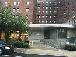
Also listed on the National Register of Historic Places are the Holmes Junior High School and Walnut Park Plaza Hotel. [1]

Education

Primary and secondary schools

The School District of Philadelphia operates public schools. Andrew Hamilton Elementary School located at S.56th St. & Spruce St., Sayre High School (formerly a middle school) is located at S.58th St & Walnut St. and West Philadelphia High School.

In 2011 the Roman Catholic Archdiocese of Philadelphia announced the closures of St. Cyprian Catholic School, as its student numbers had declined. [4]

Public libraries

Blanche A. Nixon/Cobbs Creek Branch Phila FLP CobbsCreek01.png
Blanche A. Nixon/Cobbs Creek Branch

Free Library of Philadelphia operates the Blanche A. Nixon/Cobbs Creek Branch at 5800 Cobbs Creek Parkway at the intersection of 59th Street and Baltimore Avenue. The branch opened in 1925 and was renamed in 1990 after an area activist. [5]

See also

Related Research Articles

<span class="mw-page-title-main">University City, Philadelphia</span> Neighborhood of Philadelphia in Philadelphia County, Pennsylvania, United States

University City is the easternmost portion of West Philadelphia, encompassing several Philadelphia universities. It is situated directly across the Schuylkill River from Center City.

<span class="mw-page-title-main">Northern Liberties, Philadelphia</span> Former District in Pennsylvania, United States

Northern Liberties is a neighborhood in Philadelphia, Pennsylvania, United States. Prior to its incorporation into Philadelphia in 1854, it was among the top 10 largest cities in the U.S. in every census from 1790 to 1850.

<span class="mw-page-title-main">Overbrook, Philadelphia</span> Neighborhood of Philadelphia in Philadelphia County, Pennsylvania, United States

Overbrook is an historic neighborhood that is located in the Commonwealth of Pennsylvania, United States. It is situated northwest of West Philadelphia, Philadelphia.

<span class="mw-page-title-main">West Philadelphia</span> Neighborhood of Philadelphia in Philadelphia, Pennsylvania

West Philadelphia, nicknamed West Philly, is a section of the city of Philadelphia. Although there are no officially defined boundaries, it is generally considered to reach from the western shore of the Schuylkill River, to City Avenue to the northwest, Cobbs Creek to the southwest, and the SEPTA Media/Wawa Line to the south. An alternate definition includes all city land west of the Schuylkill; this would also include Southwest Philadelphia and its neighborhoods. The eastern side of West Philadelphia is also known as University City.

<span class="mw-page-title-main">Cobbs Creek</span> River in Pennsylvania, United States

Cobbs Creek is an 11.8-mile-long (19.0 km) tributary of Darby Creek in Delaware County, Pennsylvania, in the United States. It forms an approximate border between Montgomery County and Delaware County. After Cobbs Creek passes underneath Township Line Road, it forms the border between Philadelphia County and Delaware County. It runs directly through the two sides of Mount Moriah Cemetery which spans the border of Southwest Philadelphia and Yeadon, Pennsylvania. It later joins Darby Creek before flowing into the Delaware River.

<span class="mw-page-title-main">Center City, Philadelphia</span> Neighborhood in Philadelphia, Pennsylvania

Center City includes the central business district and central neighborhoods of Philadelphia, Pennsylvania, United States. It comprises the area that made up the City of Philadelphia prior to the Act of Consolidation, 1854, which extended the city borders to be coterminous with Philadelphia County.

<span class="mw-page-title-main">Society Hill</span> United States historic place

Society Hill is a historic neighborhood in Center City Philadelphia, Pennsylvania, United States, with a population of 6,215 as of the 2010 United States Census. Settled in the early 1680s, Society Hill is one of the oldest residential neighborhoods in Philadelphia. After urban decay developed between the late 19th and early 20th centuries, an urban renewal program began in the 1950s, restoring the area and its many historic buildings. Society Hill has since become one of the most expensive neighborhoods with the highest average income and second-highest real estate values in Philadelphia. Society Hill's historic colonial architecture, along with planning and restoration efforts, led the American Planning Association to designate it, in 2008, as one of the great American neighborhoods and a good example of sustainable urban living.

<span class="mw-page-title-main">Spruce Hill, Philadelphia</span> Neighborhood of Philadelphia in Pennsylvania, United States

Spruce Hill is a neighborhood in the University City section of West Philadelphia, Pennsylvania, United States. It is situated between 40th and 46th streets and stretches from Market Street south to Woodland Avenue.

<span class="mw-page-title-main">Southwest Philadelphia</span> Neighborhood of Philadelphia in Philadelphia, Pennsylvania

Southwest Philadelphia is a section of Philadelphia, Pennsylvania, United States. The section can be described as extending from the western side of the Schuylkill River to the city line, with the SEPTA. The northern border is defined by the Philadelphia City Planning Commission as east from the city line along Baltimore Avenue moving south along 51st Street to Springfield Ave. It follows the train tracks until 49th Street. From 49th and Kingsessing Ave the line moves east along Kingsessing Ave. The line then moves south along 46th St to Paschall Ave where it jogs to join Grays Ferry where the line runs to the Schuylkill River.

<span class="mw-page-title-main">Elmwood Park, Philadelphia</span> Neighborhood of Philadelphia in Pennsylvania, United States

Elmwood Park, also known simply as Elmwood, is a neighborhood in the Southwest section of Philadelphia, Pennsylvania, United States. It borders the city line with Delaware County at Cobbs Creek, and extends to the Schuylkill River. The Eastwick neighborhood borders it to the southwest, and Kingsessing borders it on the northeast.

<span class="mw-page-title-main">Oxford Circle, Philadelphia</span> Neighborhood of Philadelphia in Philadelphia County, Pennsylvania, United States

Oxford Circle is a neighborhood in the lower Northeast section of Philadelphia, Pennsylvania, United States. Its namesake is the much used traffic circle at Roosevelt Boulevard and Oxford Avenue. The Oxford Circle neighborhood has traditionally included the areas up to Rhawnhurst and Mayfair but does not really have a fixed boundary, other than in publications about Philadelphia which are of a public relations or informational nature.

<span class="mw-page-title-main">Dunlap, Philadelphia</span> Neighborhood of Philadelphia in Pennsylvania, United States

Dunlap is a small neighborhood in the West Philadelphia section of Philadelphia, Pennsylvania, United States. The neighborhood lies between Haverford Avenue and Market Street and stretches from 46th to 52nd streets. Dunlap is squeezed between the neighborhoods of Mill Creek and Haddington and situated just north of Walnut Hill. The neighborhood is named after the former historic Thomas Dunlap School that was restored into senior homes in 1991. Dunlap is located in the 19139 ZIP Code, and is situated in the Philadelphia Police Department's 19th police district, which encompasses a large portion of West Philadelphia.

<span class="mw-page-title-main">Walnut Hill, Philadelphia</span> Neighborhood of Philadelphia in Pennsylvania, United States

Walnut Hill is a neighborhood in the West Philadelphia section of Philadelphia, Pennsylvania, United States. It is located between 45th Street and 52nd Street, bounded by Market Street and Spruce Street. Most of the neighborhood is in the northwestern part of the University City District. It is located north of the neighborhoods of Garden Court and Spruce Hill.

<span class="mw-page-title-main">Garden Court, Philadelphia</span> United States historic place

Garden Court is a neighborhood in the West Philadelphia section of Philadelphia, Pennsylvania, United States. It is located west of Spruce Hill, north of Cedar Park, east of Cobbs Creek, and south of Walnut Hill.

<span class="mw-page-title-main">Walnut Street (Philadelphia)</span>

Walnut Street is located in Center City Philadelphia and extends to the Delaware River waterfront and West Philadelphia. Walnut Street has been characterized as "the city's premier shopping district" by The Philadelphia Inquirer. A portion of the street commonly called Rittenhouse Row was ranked 12th in 2005 by Women's Wear Daily among its list of the most expensive retail streets in North America, with rents of $90 per square foot, and is home to several "upscale dining, retail and cultural" establishments. In 2013, rents rose to an average of $107 a foot, a growth of 34% over 2012 and the largest percentage growth of any retail corridor in the country.

<span class="mw-page-title-main">St. Cyprian Catholic Church (Philadelphia)</span> Church in Pennsylvania, United States

St. Cyprian Catholic Church is located on the southwest corner of 63rd St. and Hazel Ave. at 525 Cobbs Creek Parkway in Cobbs Creek, Philadelphia, Pennsylvania.

<span class="mw-page-title-main">Carroll Park, Philadelphia</span> Neighborhood of Philadelphia in Pennsylvania, United States

Carroll Park is a neighborhood in West Philadelphia, Pennsylvania, United States. Its boundaries are Lansdowne Avenue to the north, West Girard Avenue to the south, North 63rd Street to the west, and North 52nd Street to the east. Along major streets of the neighborhood, the Carroll Park Community Council, Inc. has placed banners that say “Carroll Park: Where our neighbors become friends.” The 10 trolley runs along Lansdowne Avenue and the 15 trolley runs along Girard Avenue. There is a park by the name of Carroll Park between North 59th and North 58th Streets and West Thompson Street and West Girard Avenue. Carroll Park’s residents are primarily working-class and lower-income African-Americans.

<span class="mw-page-title-main">Parkway West High School (Pennsylvania)</span> United States historic place

Parkway West High School is an American public magnet high school that is located in the Mill Creek neighborhood of Philadelphia, Pennsylvania. It shares a site with the Middle Years Alternative School for the Humanities (MYA). Both schools are part of the School District of Philadelphia.

<span class="mw-page-title-main">Girard Avenue</span> Major commercial and residential street in Philadelphia, Pennsylvania, United States

Girard Avenue is a major commercial and residential street in Philadelphia, Pennsylvania. For most of its length it runs east–west, but at Frankford Avenue it makes a 135-degree turn north. Parts of the road are signed as U.S. Route 13 and U.S. Route 30.

References

  1. 1 2 "National Register Information System". National Register of Historic Places . National Park Service. January 23, 2007.
  2. "Philadelphia MOVE Bombing Still Haunts Survivors". NPR. Retrieved April 24, 2015.
  3. Moore, Martha (May 11, 2005). "1985 bombing in Philadelphia still unsettled". USA Today. PHILADELPHIA. Retrieved April 24, 2015.
  4. "Three Catholic schools closing in Bucks County". Bucks County Courier Times . March 1, 2011. Retrieved April 22, 2020.
  5. "Blanche A. Nixon/Cobbs Creek Branch." Free Library of Philadelphia . Retrieved on November 7, 2008.

39°57′10″N75°14′09″W / 39.952912°N 75.23592°W / 39.952912; -75.23592