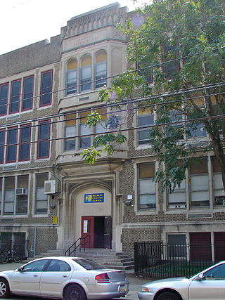
Kingsessing is a neighborhood in the Southwest section of Philadelphia, Pennsylvania, United States. On the west side of the Schuylkill River, it is next to the neighborhoods of Cedar Park and Elmwood Park, as well as the borough of Yeadon in Delaware County. It is roughly bounded by 53rd Street to the northeast, Baltimore Avenue to the northwest, Cobbs Creek and 60th Street to the southwest, and Woodland Avenue to the southeast.
Byberry is a neighborhood in the far northeast section of Philadelphia, in the U.S. state of Pennsylvania. Originally it was incorporated as the Township of Byberry and was the northeasternmost municipality of Philadelphia County before the City and County were consolidated in 1854. Its approximate boundaries are the Poquessing Creek to the north, Woodhaven Road to the south, the Roosevelt Boulevard to the west, and Thornton Road to the east.
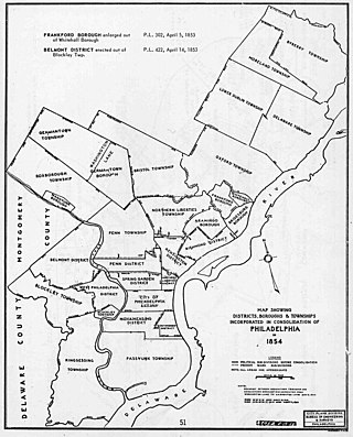
The Act of Consolidation, more formally known as the act of February 2, 1854, is legislation of the Pennsylvania General Assembly that created the consolidated City and County of Philadelphia, expanding the city's territory to the entirety of Philadelphia County and dissolving the other municipal authorities in the county.

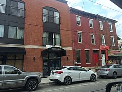
Moyamensing is an area of Philadelphia established as a Moyamensing Township during British colonial rule on the fast land of the Neck, lying between Passyunk and Wicaco. It was incorporated into Philadelphia County, Pennsylvania, United States and today encompasses several neighborhoods along the Moyamensing Avenue corridor in the South Philadelphia section of Philadelphia.
Northern Liberties Township was a township that was located in Philadelphia County, Pennsylvania. The township was later incorporated into the City of Philadelphia after the passage of the Act of Consolidation, 1854.
Aramingo Borough was a borough that was located in Philadelphia County, Pennsylvania, United States. The borough ceased to exist and was incorporated into the City of Philadelphia following the passage of the Act of Consolidation, 1854.
Belmont District was a district that existed briefly in Philadelphia County, Pennsylvania, United States. The district was created on April 14, 1853 from northern Blockley Township ceased to exist and on February 2, 1854 the district was incorporated into the City of Philadelphia following the passage of the Act of Consolidation, 1854.
Bristol Township was a township that was located in Philadelphia County, Pennsylvania, United States. The township ceased to exist and was incorporated into the City of Philadelphia following the passage of the Act of Consolidation, 1854. It is the modern day Olney-Oak Lane Planning Analysis Section, though with a slight difference in the southern border. It is in present-day North Philadelphia, although Olney-Oak Lane is sometimes considered to be separate from North Philadelphia entirely because of their unique architecture, culture and differing patterns of development.
Moreland Township was a township that was located in Philadelphia County, Pennsylvania, United States.

Oxford Township was a township in Philadelphia County, Pennsylvania, United States. The township ceased to exist and was incorporated into the City of Philadelphia following the passage of the Act of Consolidation, 1854.

Penn District was a district located in Philadelphia County, Pennsylvania, United States. The district ceased to exist and was incorporated into the City of Philadelphia following the passage of the Act of Consolidation, 1854.
Penn Township was a township that was located in Philadelphia County, Pennsylvania. The township ceased to exist and was incorporated into the City of Philadelphia following the passage of the Act of Consolidation, 1854.

Richmond District, also known as Port Richmond District, was a district that was located in Philadelphia County, Pennsylvania, United States. The district ceased to exist and was incorporated into the City of Philadelphia following the passage of the Act of Consolidation, 1854.
West Philadelphia Borough, also known as West Philadelphia District, was a borough that was located west of the Schuylkill River in Blockley Township, Philadelphia County, Pennsylvania, United States. The borough ceased to exist and was incorporated into the City of Philadelphia following the passage of the Act of Consolidation, 1854.
Whitehall Borough was a borough that was located in Philadelphia County, Pennsylvania, United States. The borough ceased to exist when it was incorporated into the City of Philadelphia on the passage of the Act of Consolidation, 1854.
Lower Dublin Township, also known as Dublin Township, was a township that was located in Philadelphia County, Pennsylvania, United States. The township ceased to exist and was incorporated into the City of Philadelphia following the passage of the Act of Consolidation, 1854.
The Baltimore Pike was an auto trail connecting Baltimore, Maryland, with Philadelphia, Pennsylvania.
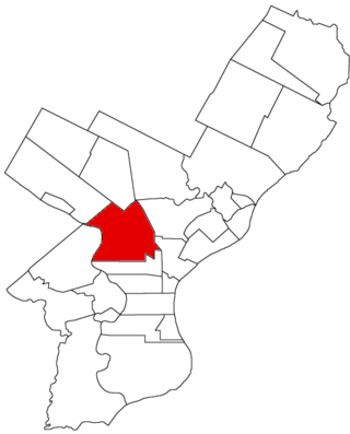
Southwest Philadelphia is a section of Philadelphia, Pennsylvania, United States. The section can be described as extending from the western side of the Schuylkill River to the city line, with the SEPTA. The northern border is defined by the Philadelphia City Planning Commission as east from the city line along Baltimore Avenue moving south along 51st Street to Springfield Ave. It follows the train tracks until 49th Street. From 49th and Kingsessing Ave the line moves east along Kingsessing Ave. The line then moves south along 46th St to Paschall Ave where it jogs to join Grays Ferry where the line runs to the Schuylkill River.

U.S. Route 1 (US 1) is a major north–south U.S. Route, extending from Key West, Florida, in the south to Fort Kent, Maine, at the Canada–United States border in the north. In the U.S. state of Pennsylvania, US 1 runs for 81 miles (130 km) from the Maryland state line near Nottingham northeast to the New Jersey state line at the Delaware River in Morrisville, through the southeastern portion of the state. The route runs southwest to northeast and serves as a major arterial road through the city of Philadelphia and for many of the suburbs in the Delaware Valley metropolitan area. South of Philadelphia, the road mostly follows the alignment of the Baltimore Pike. Within Philadelphia, it mostly follows Roosevelt Boulevard. North of Philadelphia, US 1 parallels the route of the Lincoln Highway. Several portions of US 1 in Pennsylvania are freeways, including from near the Maryland state line to Kennett Square, the bypass of Media, the concurrency with Interstate 76 and the Roosevelt Expressway in Philadelphia, and between Bensalem Township and the New Jersey state line.