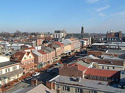
West Chester, Pennsylvania

Last updated
West Chester
Flag of West Chester, Pennsylvania.svg
Chester County Pennsylvania incorporated and unincorporated areas West Chester highlighted.svg
Location of West Chester in Chester County (left) and of Chester County in Pennsylvania (right)
USA Pennsylvania relief location map.svg
Red pog.svg
West Chester
Location of West Chester in Pennsylvania
Usa edcp relief location map.png
Red pog.svg
West Chester
Location in the United States
North America laea relief location map with borders.jpg
Red pog.svg
West Chester
West Chester (North America)
Coordinates: 39°57′31″N75°36′18″W / 39.95861°N 75.60500°W / 39.95861; -75.60500
Country Flag of the United States.svg  United States
State Flag of Pennsylvania.svg  Pennsylvania
County Flag of Chester County, Pennsylvania.svg Chester
Incorporated1799;225 years ago (1799)
Government
  Mayor Lillian DeBaptiste (D) [1] [2]
Area
[3]
  Total1.85 sq mi (4.78 km2)
  Land1.85 sq mi (4.78 km2)
  Water0.00 sq mi (0.00 km2)
Elevation
446 ft (136 m)
Population
 (2023) [4]
  Total18,750
  Density10,114.30/sq mi (3,904.69/km2)
Time zone UTC-5 (EST)
  Summer (DST) UTC-4 (EDT)
ZIP Codes
19380–19383, 19388
Area code(s) 484, 610
Website west-chester.com

West Chester is a borough and the county seat of Chester County, Pennsylvania, United States. [5] Located within the Philadelphia metropolitan area, the borough had a population of 18,461 at the 2010 census. [6] West Chester is the mailing address for most of its neighboring townships. When calculated by mailing address, the population as of the 2010 U.S. Census was 108,696, which would make it the 10th largest city by mailing address in the state of Pennsylvania. [7]

Contents

Much of the West Chester University of Pennsylvania North Campus and the Chester County government are located within the borough. The center of town is located at the intersection of Market and High Streets.

History

The area was originally known as Turk's Head—after the inn of the same name located in what is now the center of the borough. [8] West Chester has been the seat of government in Chester County since 1786 when the seat was moved from nearby Chester in what is now Delaware County. The borough was incorporated in 1799. [9] In the heart of town is its courthouse, a classical revival building designed in the 1840s by Thomas U. Walter, one of the architects for the Capitol in Washington, D.C. [10] In the 18th century West Chester was a center of clockmaking. Irish revolutionary Theobald Wolfe Tone briefly lived in West Chester during his exile.[ citation needed ] In the late 19th century the Hoopes, Bro. and Darlington company became a major wheelworks, first for wagons and later automobiles. [11] [12] In the early 20th century, an important industry was the Sharples cream separator company. [13] In the late 20th century, Commodore International, one of the pioneers of home computers, giving its headquarters as West Chester, was located approximately a mile northeast of the borough.[ citation needed ]

The West Chester Downtown Historic District was listed on the National Register of Historic Places in 1985. Other listed buildings are the Bank of Chester County, Buckwalter Building, Butler House, Chester County Courthouse, William Everhart Buildings, Farmers and Mechanics Building, First Presbyterian Church of West Chester, New Century Clubhouse, Joseph Rothrock House, Sharples Homestead, Sharples Separator Works, Warner Theater, West Chester Boarding School for Boys, and components of West Chester State College Quadrangle Historic District. [14]

Geography

Gay Street in downtown West Chester Gay Street WB past Church Street West Chester.jpeg
Gay Street in downtown West Chester

West Goshen Township borders West Chester to the north, south, and east, while East Bradford Township borders West Chester to the west. The borough straddles the Brandywine Creek and Chester Creek watersheds. [15] It is located 25 miles (40 km) west of Philadelphia and 17 miles (27 km) north of Wilmington, Delaware.

According to the United States Census Bureau, the borough has a total area of 1.8 square miles (5 km2), all land.

Climate

As with much of southeastern Pennsylvania east of the Appalachian mountains, West Chester lies in the transition zone between the humid continental (Köppen: Dfa) and humid subtropical (Köppen: Cfa) climate zones, with generally more characteristics of the former than the latter. [16] Summers are hot and humid and winters are cold but variable. Annual high temperatures average between 39.0 °F (3.9 °C) and 85.4 °F (29.7 °C), annual low temperatures average between 22.2 °F (−5.4 °C) and 64.4 °F (18.0 °C), with the record high being 105 °F (41 °C), and record low being −16 °F (−27 °C). [17]

Annual precipitation averages 46.7 inches (119 cm), and annual snowfall averages 27.7 inches (70 cm). [17]

Climate data for West Chester, Pennsylvania
MonthJanFebMarAprMayJunJulAugSepOctNovDecYear
Mean daily maximum °F (°C)39.0
(3.9)
40.5
(4.7)
50.8
(10.4)
62.1
(16.7)
72.7
(22.6)
80.9
(27.2)
85.4
(29.7)
83.5
(28.6)
77.1
(25.1)
65.9
(18.8)
54.1
(12.3)
42.2
(5.7)
62.9
(17.1)
Daily mean °F (°C)30.7
(−0.7)
31.6
(−0.2)
40.9
(4.9)
51.2
(10.7)
61.5
(16.4)
70.2
(21.2)
74.9
(23.8)
73.2
(22.9)
66.4
(19.1)
55.1
(12.8)
44.6
(7.0)
33.8
(1.0)
52.8
(11.6)
Mean daily minimum °F (°C)22.2
(−5.4)
22.6
(−5.2)
30.8
(−0.7)
40.2
(4.6)
50.3
(10.2)
59.5
(15.3)
64.4
(18.0)
62.9
(17.2)
55.7
(13.2)
44.3
(6.8)
35.0
(1.7)
25.5
(−3.6)
42.8
(6.0)
Average precipitation inches (mm)3.5
(89)
3.3
(84)
3.8
(97)
3.7
(94)
4
(100)
4.3
(110)
4.5
(110)
4.6
(120)
4.1
(100)
3.6
(91)
3.6
(91)
3.7
(94)
46.7
(1,180)
Average snowfall inches (cm)7
(18)
8.6
(22)
4.6
(12)
0.9
(2.3)
0.0
(0.0)
0.0
(0.0)
0.0
(0.0)
0.0
(0.0)
0.0
(0.0)
0.1
(0.25)
1.2
(3.0)
5.3
(13)
27.7
(70)
Source: Weatherbase

Demographics

Historical population
CensusPop.Note
1800 374
1810 47125.9%
1820 55217.2%
1830 1,258127.9%
1840 2,15271.1%
1850 3,17247.4%
1860 4,75750.0%
1870 5,63018.4%
1880 7,04625.2%
1890 8,02813.9%
1900 9,52418.6%
1910 11,76723.6%
1920 11,717−0.4%
1930 12,3255.2%
1940 13,2897.8%
1950 15,16814.1%
1960 15,7053.5%
1970 19,30122.9%
1980 17,435−9.7%
1990 18,0413.5%
2000 17,861−1.0%
2010 18,4613.4%
2020 18,6711.1%
U.S. Decennial Census [18]
Old Chester County Courthouse. The new Chester County Justice Center is located at West Market St. and North Darlington St. Chester County Courthouse.jpg
Old Chester County Courthouse. The new Chester County Justice Center is located at West Market St. and North Darlington St.

At the 2010 census, the borough was 72.1% non-Hispanic White, 12.1% Black or African American, 0.2% Native American, 1.4% Asian, and 2.4% was of two or more races. About 13.4% of the population was of Hispanic or Latino ancestry. [19]

As of the census [20] of 2000, 17,861 people, 6,265 households, and 2,662 families resided in the borough. The population density was 9,703.3 inhabitants per square mile (3,746.5/km2). The 6,541 housing units averaged 3,553.5 per square mile (1,372.6/km2). The racial makeup of the borough was 75.44% White, 17.08% Black, 3.64% from other races, 1.46% Asian, 0.31% Native American, 0.07% Pacific Islander, and 2.00% from two or more races. Hispanics or Latinos of any race were 8.94%.

Of the 6,265 households, 19.1% had children under the age of 18 living in them, 26.8% were married couples living together, 12.1% had a female householder with no husband present, and 57.5% were not families. About 35.3% of all households were made up of individuals, and 7.8% had someone living alone who was 65 years of age or older. The average household size was 2.31 and the average family size was 2.95.

In the borough the population was spread out, with 13.4% under the age of 18, 37.7% from 18 to 24, 26.6% from 25 to 44, 13.3% from 45 to 64, and 9.0% who were 65 years of age or older. The median age was 25 years. For every 100 females, there were 88.4 males. For every 100 females age 18 and over, there were 85.7 males.

The median income for a household in the borough from 2018 to 2022 was $71,875. [21] The per capita income for the borough was $41,443. 21% of the population lives below the poverty line. [22]

Economy

Corporate headquarters include:

QVC has its headquarters and television studios in West Goshen Township, [24] [25] near West Chester. It is located in the same buildings that were once the corporate headquarters of Commodore International. Electronics Boutique, when it existed as an independent company, had its headquarters in West Goshen Township, [26] [27] in proximity to West Chester. [25] [28]

Among the major shopping centers in the area is Bradford Plaza, a 22-acre property with a 161,000-square-ft center which sold in 2014 to New York Life for $35.7 million. [29]

Culture and media

The West Chester Public Library has provided library services to area residents since 1872. It currently has a collection of 50,000 items and receives 110,000 visits every year. [30] The Francis Harvey Green Library on the university campus has additional collections. [31]

The Daily Local News , headquartered in West Chester, covers Chester County events. [32] WCHE (1520 AM) broadcasts from downtown West Chester and is a local commercial radio station that provides news and entertainment to Chester County. The Quad is the student-run newspaper of West Chester University. Published since 1932, it covers not only campus events, but also regional and national news. [33] Radio station WCUR (91.7 FM) broadcasts from the borough and is managed by university students. [34]

Transportation

Roads and highways

US 322 Business in West Chester 2022-09-05 09 21 13 View west along U.S. Route 322 Business (Hannum Avenue) just west of Wayne Street in West Chester, Chester County, Pennsylvania.jpg
US 322 Business in West Chester

As of 2011, there were 33.82 miles (54.43 km) of public roads in West Chester, of which 5.36 miles (8.63 km) were maintained by Pennsylvania Department of Transportation (PennDOT) and 28.46 miles (45.80 km) were maintained by the borough. [35]

US 202 and US 322 are the major highways serving the area, though both bypass West Chester Borough on the limited-access West Chester Bypass. US 202 heads northeast to King of Prussia and south to Wilmington, Delaware while US 322 heads northwest to Downingtown and southeast to Chester. US 322 Business still follows the original alignment of US 322 and part of the original alignment of US 202 through West Chester along Hannum Avenue, Chestnut and Market streets, and South High Street.

The main east–west road to West Chester is West Chester Pike, which begins in Upper Darby Township, Delaware County, just outside Philadelphia, and is part of Pennsylvania Route 3 (PA 3). [36] The West Chester Pike originally existed as a private turnpike connecting Philadelphia and West Chester between 1850 and 1918, when it became a public road. [37] In West Chester, PA 3 follows Market Street eastbound and Gay Street westbound. The main north–south road in West Chester is High Street. To the north of town, the road is known as Pottstown Pike, which connects to PA 100 near Exton (PA 100 formerly ran through town). To the south of town, the road is known as Wilmington-West Chester Pike. Other state routes serving West Chester include PA 162 and PA 842, which head west towards Unionville, and PA 52, which heads southwest towards Kennett Square. [36]

Public transportation

West Chester Transportation Center SEPTA West Chester Transportation Center.jpg
West Chester Transportation Center

West Chester is home to the West Chester Transportation Center, which serves as a parking garage for the Chester County Justice Center and a bus terminal, which is located on the lower level of the facility. Three of SEPTA's Suburban Division bus routes serve West Chester. The Route 92 bus connects West Chester to the King of Prussia Transit Center, the Route 104 bus runs between West Chester University and the 69th Street Transportation Center, mostly following West Chester Pike, and the Route 135 bus connects West Chester to Exton, Downingtown, and Coatesville. [38] The Route 104 bus replaced a trolley service that connected West Chester to Philadelphia along the West Chester Pike between 1898 and the 1950s. [37] West Chester is also served by the Transportation Management Association of Chester County's SCCOOT, which provides service to Kennett Square and Oxford. [38]

Until September 1986, West Chester was served by SEPTA's Media/Wawa Line commuter rail line, then known as the Media/West Chester Line. Service on the line was discontinued because of poor track conditions west of Elwyn station. At the time, SEPTA had limited funds for the necessary repairs and offered Chester County the option of either improving the rail line or expanding parking availability at the nearby Exton station on SEPTA's Paoli/Thorndale Line. The county opted for the latter, and service on the line was cut back to Elwyn (service was re-extended to Wawa station in August 2022). The rail line into West Chester is used by the West Chester Railroad, a heritage railroad. [39]

Government

The borough is governed by the town council form of government. Led by the Borough Manager, there are seven council members, each representing one of the seven voting wards. The council controls all departments except the Police Department (the Mayor directs Police Department activities through the Chief of Police). The mayor and council members are directly elected by borough voters.

On January 3, 2022, Lillian DeBaptiste (D), daughter of former mayor Clifford DeBaptiste (R), was sworn in as mayor. [41]

Council members

as of November 5,2021:

WardCouncil memberPartyTerm ends
1Patrick McCoy Democratic 2025
2Nick Allen Democratic 2023
3Brian McGinnis Democratic 2025
4Michael Stefano Democratic 2023
5Sheila Vaccaro Democratic 2025
6Bernie Flynn Democratic 2023
7Lisa Dorsey Democratic 2025

Education

Public schools

The West Chester Area School District, an independent entity, manages the area's public school system. All of the secondary schools operated by the district serve sections of West Chester borough: they are three high schools (Henderson High School, West Chester East High School, Rustin High School) and three middle schools (E.N. Peirce Middle School, J.R. Fugett Middle School, G.A. Stetson Middle School). [42]

Elementary schools serving sections of West Chester borough include: East Bradford, East Goshen, Hillsdale, Greystone, Sarah Starkweather, and Westtown-Thornbury. [43] Previously the following also included sections in West Chester borough: Exton, Fern Hill, Glen Acres, Mary C. Howse, and Penn Wood. Under some zoning proposals c.2018, Exton, Glen Acres, Howse, and Penn Wood would no longer serve portions of West Chester borough. [44]

Private schools

Darlington Seminary was a nonsectarian girls' school Darlington Seminary (History of Chester County, Pennsylvania, with genealogical and biographical sketches, 1881).png
Darlington Seminary was a nonsectarian girls' school
St. Agnes School St. Agnes Parochial School (West Chester, Pennsylvania) 4.jpg
St. Agnes School

St. Agnes School, a K-8 school of the Roman Catholic Archdiocese of Philadelphia, is in the borough limits. It opened in 1871. As of 2020 its enrollment is over 300. [45]

There are other Catholic K–8 schools with West Chester postal addresses:

Colleges and universities

Much of West Chester University's North Campus is located in the borough, south of the commercial and retail center. [51]

Delaware County Community College is the community college system for Chester County. [52]

Public libraries

West Chester Public Library is the community library. [53]

Entertainment

West Chester has a variety of places to visit, including restaurants, shops, parks, and historical sites. Some popular tourist attractions include the Uptown! Knauer Performing Arts Center, the Chester County History Center, the American Helicopter Museum, the West Chester Railroad, and QVC studio tours. [54] People can also explore Downtown West Chester, which features a selection of dining and retail options along with historical buildings. [55]

West Chester is home to West Chester United SC, a lower level professional soccer club that currently competes in both the National Premier Soccer League and USL League Two. Home matches are played at Kildare's Field. The organization also fields a side in the United Soccer League of Pennsylvania, a fully-amateur state league.

Notable people

Related Research Articles

<span class="mw-page-title-main">Chester County, Pennsylvania</span> County in Pennsylvania, United States

Chester County, colloquially referred to as Chesco, is a county in the Commonwealth of Pennsylvania. It is located in the Delaware Valley region, located in the southeastern part of the state. As of the 2020 census, the population was 534,413, increasing by 7.1% from 498,886 in 2010. The county seat is the Borough of West Chester. The most populous of its 73 municipalities is Tredyffrin Township. The most populous boroughs are West Chester and Phoenixville. Coatesville is the only municipality in the County organized under the City form of government, a technical rather than demographic distinction. Chester County was one of the three original Pennsylvania counties created by William Penn in 1682. It was named for Chester, England.

<span class="mw-page-title-main">East Goshen Township, Pennsylvania</span> Township in Pennsylvania, United States

East Goshen Township is a township in Chester County, Pennsylvania, United States. The population was 18,026 at the 2010 census.

<span class="mw-page-title-main">Exton, Pennsylvania</span> Census-designated place in Pennsylvania, United States

Exton is a census-designated place (CDP) in West Whiteland Township in Chester County, Pennsylvania, United States. Its population was 5,622 at the 2020 census. The Exton Square Mall and Main Street at Exton are both located within Exton along with several other shopping centers, making Exton the major shopping district in Chester County.

<span class="mw-page-title-main">Malvern, Pennsylvania</span> Borough in Pennsylvania, United States

Malvern is a borough in Chester County, Pennsylvania, United States. Malvern is the terminus of the Main Line, a series of highly affluent Philadelphia suburbs located along the railroad tracks of the Pennsylvania Railroad. It is 19.4 miles (31.2 km) west of Philadelphia. The population was 3,419 at the 2020 census.

<span class="mw-page-title-main">Thornbury Township, Chester County, Pennsylvania</span> Township in Pennsylvania, United States

Thornbury Township is a township in Chester County, Pennsylvania, United States. The population was 3,017 at the 2010 census. It is adjacent to, and was once joined with, Thornbury Township, Delaware County.

<span class="mw-page-title-main">West Goshen Township, Pennsylvania</span> Township in Pennsylvania, United States

West Goshen Township is a township in Chester County, Pennsylvania, United States. The population was 23,040 at the 2020 census. In 2013, Money Magazine voted West Goshen as the 10th best place to live in America. West Goshen has also been ranked in the top 15 places to live in America from 2014 to 2017 and is also at the top of best neighborhoods to raise a family in Pennsylvania every year.

<span class="mw-page-title-main">West Whiteland Township, Pennsylvania</span> Township in Pennsylvania, United States

West Whiteland Township is a township in Chester County, Pennsylvania, United States. The population was 19,632 at the 2020 census.

<span class="mw-page-title-main">Westtown Township, Pennsylvania</span> Township in Pennsylvania, United States

Westtown Township is a township in Chester County, Pennsylvania, United States. The population was 10,827 at the 2010 census.

<span class="mw-page-title-main">Marple Township, Pennsylvania</span> Township in Pennsylvania, United States

Marple Township is a township in Delaware County, Pennsylvania, United States. It contains the census designated place of Broomall. The population was estimated at 23,743 as of 2015. ZIP codes include mainly 19008, as well as 19064 and 19063. The township is run by Marple Township board of commissioners.

<span class="mw-page-title-main">Middletown Township, Delaware County, Pennsylvania</span> Home rule municipality in Pennsylvania, United States

Middletown Township is a township in Delaware County, Pennsylvania, United States. The population was 15,807 at the 2010 census. The Pennsylvania State University has an undergraduate satellite campus called Penn State Brandywine located in the north-central portion of the township. Located outside of Philadelphia, it constitutes part of the Delaware Valley.

<span class="mw-page-title-main">Newtown Township, Delaware County, Pennsylvania</span> Township in Pennsylvania, United States

Newtown Township, also referred to by the name of its post office of Newtown Square, is a township in Delaware County, Pennsylvania, United States. Prior to 1789, it was part of Chester County. As of the 2020 census, the population was 15,002.

<span class="mw-page-title-main">Norwood, Pennsylvania</span> Borough in Pennsylvania, United States

Norwood is a borough that is located in Delaware County, Pennsylvania, United States. The population was 5,890 at the time of the 2010 census.

<span class="mw-page-title-main">Ridley Township, Pennsylvania</span> Township in Pennsylvania, United States

Ridley Township is a township in Delaware County, Pennsylvania, United States. The population was 30,768 at the 2010 census. Ridley Township contains the (CDPs) of Folsom and Woodlyn, along with the unincorporated communities of Crum Lynne and Holmes and a portion of Secane.

<span class="mw-page-title-main">Upper Providence Township, Delaware County, Pennsylvania</span> Home rule municipality in Pennsylvania, United States

Upper Providence Township is a township in Delaware County, Pennsylvania, United States, located around and to the north of the borough of Media, and approximately 15 miles (24 km) west of center city Philadelphia. The population was 10,142 at the 2010 census. The township lies between Ridley Creek on the west and Crum Creek on the east. Most of Ridley Creek State Park is in the township, towards the northern edge. Zoning is 98% residential, 1% commercial and 1% industrial, with minimal space zoned to commercial business.

<span class="mw-page-title-main">Pennsylvania Route 3</span> State highway in Chester, Delaware, and Philadelphia counties in Pennsylvania, US

Pennsylvania Route 3 is a 24.3-mile (39.1 km) state highway located in the southeastern portion of Pennsylvania. The route runs from U.S. Route 322 Business in West Chester east to PA 611 in Philadelphia.

<span class="mw-page-title-main">West Chester Area School District</span> School district in Pennsylvania, United States

The West Chester Area School District (WCASD) serves the borough and surrounding townships of West Chester, Pennsylvania, United States. The other parts include the surrounding townships of East Bradford, East Goshen, Thornbury, West Goshen, West Whiteland, and Westtown, all in Chester County, as well as Thornbury Township in adjacent Delaware County. The WCASD consists of eleven elementary schools, three middle schools, and three high schools, as of the fall 2022 school year. Elementary schools include grades 1-5, middle schools grades 6-8, and high schools grades 9-12.

<span class="mw-page-title-main">Pennsylvania Route 352</span> State highway in Pennsylvania, US

Pennsylvania Route 352 is a 19-mile (31 km) north–south route that runs from U.S. Route 13 Business in Chester, Delaware County, north to US 30 in Frazer, Chester County. The route passes through suburban areas of Delaware and Chester counties west of Philadelphia, serving Parkside, Brookhaven, Elwyn, Lima, Gradyville, and Goshenville. PA 352 is a four- to five-lane road between Brookhaven and US 1, otherwise it is generally a two-lane road. The route intersects Interstate 95 (I-95) in Chester and US 1 near Lima at interchanges. PA 352 was first designated by 1928 to run between its current termini. A portion of the route between Brookhaven and US 1 was realigned to a straighter alignment in the 1950s. By 1980, PA 352 was realigned to a short concurrency with PA 3 to avoid intersecting it at a sharp angle.

<span class="mw-page-title-main">U.S. Route 13 in Pennsylvania</span> Highway in Pennsylvania

U.S. Route 13 (US 13) is a United States Numbered Highway running from Fayetteville, North Carolina, north to Morrisville, Pennsylvania. The route runs for 49.359 miles (79.436 km) through the Delaware Valley in the U.S. state of Pennsylvania. The route enters the state from Delaware in Marcus Hook, Delaware County. It continues northeast through Delaware County, passing through the city of Chester before heading through suburban areas along Chester Pike to Darby. US 13 enters the city of Philadelphia on Baltimore Avenue and runs through West Philadelphia to University City, where it turns north along several city streets before heading east across the Schuylkill River along Girard Avenue. The route turns north and heads to North Philadelphia, where it runs northeast along Hunting Park Avenue. US 13 becomes concurrent with US 1 on Roosevelt Boulevard, continuing into Northeast Philadelphia. US 13 splits southeast on a one-way pair of streets before heading northeast out of the city on Frankford Avenue. The route continues into Bucks County as Bristol Pike, heading northeast to Bristol, where it turns into a divided highway. US 13 becomes a freeway in Tullytown and continues north to its terminus at US 1 in Falls Township, near Morrisville. US 13 roughly parallels Interstate 95 (I-95) through its course in Pennsylvania.

<span class="mw-page-title-main">U.S. Route 202 in Pennsylvania</span> US Highway in Pennsylvania

U.S. Route 202 is a US Highway running from New Castle, Delaware, northeast to Bangor, Maine. The route runs through the southeastern part of the U.S. state of Pennsylvania, passing through the western and northern suburbs of Philadelphia in the Delaware Valley metropolitan area. US 202 serves largely as a toll-free bypass around the city, avoiding the busy traffic and congestion on Interstate 95 (I-95). It is signed north–south and follows a general southwest–northeast direction through the state, serving West Chester, King of Prussia, Bridgeport, Norristown, Montgomeryville, Doylestown, and New Hope. US 202 enters Pennsylvania from Delaware and heads north as a divided highway, where it becomes concurrent with US 322 at an intersection with US 1 in Painters Crossing. The two routes run north and become a freeway that bypasses West Chester to the east, with US 322 splitting from US 202. US 202 continues north and east along the freeway to King of Prussia, where it reverts to an at-grade divided highway following an interchange with I-76. The route becomes a one-way pair as it passes through Bridgeport and Norristown before both directions rejoin and the road continues northeast. US 202 follows an expressway-grade parkway between Montgomeryville and Doylestown prior to bypassing Doylestown to the south along a freeway. The route continues northeast as an at-grade road to New Hope, where it turns into a freeway again before it crosses the Delaware River on the New Hope–Lambertville Toll Bridge into New Jersey.

<span class="mw-page-title-main">West Chester East High School</span> High school in West Chester, Pennsylvania, United States

West Chester East High School is a public four-year high school located in West Goshen Township, Pennsylvania, United States, near West Chester.

References

  1. "DeBaptiste takes over as new West Chester mayor". 3 January 2022.
  2. "Lillian DeBaptiste for Mayor - Home". Archived from the original on 2022-01-07. Retrieved 2022-01-07.
  3. "ArcGIS REST Services Directory". United States Census Bureau. Retrieved October 16, 2022.
  4. "Census Population API". United States Census Bureau. Retrieved Oct 12, 2022.
  5. "Find a County". National Association of Counties. Retrieved 2011-06-07.
  6. United States Census [ dead link ]
  7. "Pennsylvania Zip Codes by Population". pennsylvania-demographics.com. Retrieved July 12, 2021.
  8. "West Chester, Pennsylvania". Thebrandywine.com. July 26, 2001. Retrieved August 12, 2012.
  9. "Archived copy". Archived from the original on 2009-12-08. Retrieved 2009-12-24.{{cite web}}: CS1 maint: archived copy as title (link)
  10. Enter your Company or Top-Level Office (January 19, 2011). "Chester County: Courthouse History". Dsf.chesco.org. Archived from the original on February 5, 2012. Retrieved August 12, 2012.
  11. West Chester, past and present: centennial souvenir with celebration proceedings. Daily Local News, West Chester, PA. 1899. p.  125.
  12. "Keeping the wheels turning in West Chester". Daily Local News. Archived from the original on July 23, 2013. Retrieved February 14, 2012.
  13. "Cream Separators Page 2". Dairyantiques.com. Archived from the original on October 4, 2011. Retrieved August 12, 2012.
  14. "National Register Information System". National Register of Historic Places . National Park Service. July 9, 2010.
  15. "Watersheds of Chester County". Chester County. Retrieved November 4, 2014.
  16. Climate Summary for West Chester, Pennsylvania
  17. 1 2 "West Chester, Pennsylvania Travel Weather Averages". Weatherbase. Retrieved August 12, 2012.
  18. "Census of Population and Housing". Census.gov. Retrieved June 4, 2016.
  19. Copeland, Larry (10 March 2011). "Philadelphia gains, Pittsburgh shrinks in population". USA Today.
  20. "U.S. Census website". United States Census Bureau . Retrieved 2008-01-31.
  21. "QuickFacts - West Chester borough, Pennsylvania".
  22. "QuickFacts - West Chester borough, Pennsylvania".
  23. McGann, Mike (July 18, 2013). "Chamber touts benefits of social capital". Coatsville Timers. Retrieved December 4, 2013.
  24. "Directions to QVC Studio Park Archived 2010-06-11 at the Wayback Machine ." QVC. Retrieved on August 11, 2010.
  25. 1 2 "West Goshen township, Chester County, Pennsylvania Archived 2011-06-08 at the Wayback Machine ." U.S. Census Bureau. Retrieved on August 11, 2010.
  26. Moran, Sarah E. "County jobless rate worsens Archived 2012-02-29 at the Wayback Machine ." Daily Local News . Tuesday November 1, 2005. Retrieved on August 11, 2010.
  27. "Contact." Electronic Boutique. June 11, 2004. Retrieved on August 11, 2010. "931 South Matlack St. West Chester, PA 19382."
  28. "Corporate Office Positions." Electronic Boutique. June 9, 2001. Retrieved on August 11, 2010.
  29. Kostelni, Natalie (2014-06-20). "West Chester shopping center sells for $35.7M". Philadelphia Business Journal .[ permanent dead link ]
  30. "Short History" (PDF). West Chester Public Library. Archived from the original (PDF) on October 5, 2014. Retrieved November 25, 2014.
  31. "University Libraries". West Chester University . Retrieved February 12, 2021.
  32. "Daily Local News". Daily Local News . Retrieved November 25, 2014.
  33. "The Quad: About". The Quad. Retrieved November 25, 2014.
  34. "91.7 WCUR The Curve". WCUR . Retrieved November 25, 2014.
  35. "West Chester Borough map" (PDF). PennDOT. Retrieved March 12, 2023.
  36. 1 2 Chester County, Pennsylvania (Map) (17th ed.). 1"=2000'. ADC Map. 2006. ISBN   0-87530-778-7.
  37. 1 2 Edgcumbe, Stephen J. (2012). West Chester Pike. Images of America. Charleston, SC: Arcadia Publishing. p. 8. ISBN   9780738592442 . Retrieved December 15, 2014.
  38. 1 2 Chester County Ride Guide (Map). Chester County Planning Commission. Retrieved October 15, 2021.
  39. "West Chester Railroad" . Retrieved December 5, 2022.
  40. "Marley & Me Filming in West Chester". chestercountymoms.com. Archived from the original on December 25, 2010. Retrieved October 16, 2010.
  41. "DeBaptiste takes over as new West Chester mayor". Daily Local. 2022-01-03. Retrieved 2022-01-10.
  42. "Attendance/District Boundary Maps" (PDF). West Chester Area School District . Retrieved 2023-12-29. - Accessed from here, PDF capture with zoom on West Chester.
    "School Boundary Adjustment Draft SK8C - Current Boundaries with Zones of Change Archived 2018-09-26 at the Wayback Machine " (Secondary). West Chester Area School District. Retrieved on September 26, 2018.
  43. "Attendance/District Boundary Maps" (PDF). West Chester Area School District . Retrieved 2023-12-29. - Accessed from here, PDF capture with zoom on West Chester
  44. "School Boundary Adjustment Draft SK8C - Current Boundaries with Zones of Change Archived 2018-09-26 at the Wayback Machine " (Elementary). West Chester Area School District. Retrieved on September 26, 2018.
  45. "About". St. Agnes School. Retrieved 2020-05-03.
  46. 1 2 3 "West Chester Area Council of Governments Map Archived 2018-09-26 at the Wayback Machine ." On the website of West Goshen Township. Retrieved on September 26, 2018. Includes maps of various townships around West Chester borough.
  47. "School". SS. Peter and Paul Parish. Retrieved 2020-04-23. Saints Peter & Paul School 1327 Boot Road West Chester, PA 19380 - Compare with the township maps.
  48. "History". SS. Peter and Paul Parish. Retrieved 2020-04-23.
  49. "Home". SS. Simon and Jude School. Retrieved 2020-04-23. Saints Simon and Jude School 6 Cavanaugh Court West Chester, PA 19382 - Compare with the township map
  50. "Home". St. Maximilian Kolbe School. Retrieved 2020-04-23. School Address St. Maximilian Kolbe School 300 Daly Drive West Chester, PA 19382 - Compare with the township map
  51. "North Campus Map." West Chester University. Retrieved on October 9, 2018. See: "West Chester Area Council of Governments Map Archived 2018-09-26 at the Wayback Machine ."
  52. "Chester County". Delaware County Community College . Retrieved 2023-12-29.
  53. "Home". West Chester Public Library. Retrieved 2022-10-19. 415 N. Church Street West Chester, Pennsylvania 19380
  54. "THE 15 BEST Things to Do in West Chester - 2023 (with Photos)". Tripadvisor. Retrieved 2023-03-20.
  55. "Historic Towns". VisitPA. Retrieved 2023-03-20.