Parker Ford, Pennsylvania | |
---|---|
Unincorporated community | |
Coordinates: 40°11′58″N75°35′02″W / 40.19944°N 75.58389°W | |
Country | United States |
State | Pennsylvania |
County | Chester |
Township | East Coventry |
Elevation | 121 ft (37 m) |
Time zone | UTC-5 (Eastern (EST)) |
• Summer (DST) | UTC-4 (EDT) |
ZIP code | 19475 |
Area code(s) | 610 and 484 |
GNIS feature ID | 1183314 [1] |
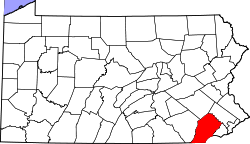
Parker Ford is an unincorporated community in East Coventry Township, Chester County, Pennsylvania, United States. Maps show it at the intersection of Pennsylvania Route 724 and Bethel Church Road/Linfield Road. Linfield Road crosses the Schuylkill River to Linfield, an unincorporated village in Limerick Township, Montgomery County. [2]
Birmingham Township is a township in Chester County, Pennsylvania, United States. The population was 4,085 at the 2020 census.
East Coventry Township is a township in Chester County, Pennsylvania, United States. The population was 7,068 at the 2020 census.
East Vincent Township is a township in Chester County, Pennsylvania, United States. The population was 6,821 at the 2010 census.
Easttown Township is a township in Chester County, Pennsylvania, United States. The population was 10,984 at the 2020 census. The township, which lies in the western half of Philadelphia's Main Line suburbs, comprises mostly parts of two unincorporated areas: Devon and Berwyn. A small portion of the township has a Paoli address.
Warwick Township is a township in Chester County, Pennsylvania, United States. The population was 2,507 at the 2010 census.
Concord Township is a township in Delaware County, Pennsylvania, United States. The population was 17,231 at the 2010 census. It contains the unincorporated communities of Concordville and Glen Mills.
Pennsylvania Route 100 is a 59.4-mile (95.6 km) long state highway in the U.S. state of Pennsylvania that runs from U.S. Route 202 near West Chester north to PA 309 in Pleasant Corners. The route runs between the western suburbs of Philadelphia and the Lehigh Valley region of the state, serving Chester, Montgomery, Berks, and Lehigh counties. PA 100 intersects several important highways, including US 30 in Exton, the Pennsylvania Turnpike (Interstate 76, near Lionville, US 422 near Pottstown, US 222 in Trexlertown, and I-78/US 22 in Fogelsville. Several sections of PA 100 are multi-lane divided highway with some interchanges, including between US 202 and the Pennsylvania Turnpike in Chester County between south of Pottstown and New Berlinville, and between Trexlertown and Fogelsville.
Chadds Ford is a census-designated place (CDP) in Delaware and Chester counties, Pennsylvania, United States, comprising the unincorporated communities of Chadds Ford and Chadds Ford Knoll. It was first listed as a CDP prior to the 2020 census.
Pennsylvania Route 724 is a 30-mile (48 km) road in the U.S. commonwealth of Pennsylvania that runs from U.S. Route 422 in Sinking Spring southeast to PA 23 near Phoenixville. PA 724 travels through Berks and Chester counties. The route runs through the southern suburbs of Reading, passing through Shillington and Kenhorst. Past the Reading area, PA 724 continues southeast parallel to the Schuylkill River, passing through or near Birdsboro, Pottstown, and Spring City. The route intersects many roads including US 222 near Shillington, PA 10 and Interstate 176 (I-176) southeast of Reading, PA 345 in Birdsboro, and PA 100 and US 422 near Pottstown.
Linfield is an unincorporated village, part of Limerick Township in Montgomery County, Pennsylvania, United States. It is located approximately 35 miles northwest of Philadelphia, along the Schuylkill River.
Springdell is an unincorporated community in West Marlborough Township in Chester County, Pennsylvania, United States. Springdell is located at the intersection of Pennsylvania Route 841 and Spring Dell Road.
Pocopson is an unincorporated community in Pocopson Township in Chester County, Pennsylvania, United States. Pocopson is located at the intersection of Pennsylvania Route 926 and Pocopson Road.
Devault is an unincorporated community in Charlestown Township in Chester County, Pennsylvania, United States. Devault is located at the intersection of Pennsylvania Route 29, Phoenixville Pike, and Charlestown Road.
Lenape is an unincorporated community in Pocopson Township in Chester County, Pennsylvania, United States. Lenape is centered on the intersection of Pennsylvania Route 52 and Pocopson Road, west of the Brandywine Creek.
Mendenhall is an unincorporated community in Kennett Township in Chester County, Pennsylvania, United States. Mendenhall is located at the intersection of Pennsylvania Route 52 and Hillendale Road.
Chesterville is an unincorporated community in Franklin Township in Chester County, Pennsylvania, United States. Chesterville is located at the intersection of Pennsylvania Route 841, Chesterville Road, and North Creek Road.
Kelton is an unincorporated community in Penn Township in Chester County, Pennsylvania, United States. Kelton is located at the intersection of Pennsylvania Route 796 and Kelton Road.
Brandamore is an unincorporated community in West Brandywine Township in Chester County, Pennsylvania, United States. Brandamore is located at the intersection of Hibernia Road and Brandamore Road, north of Coatesville.
Suplee is an unincorporated community in Honey Brook Township in Chester County, Pennsylvania, United States. Suplee is located along Suplee Road, east of Honey Brook.
Dilworthtown is an unincorporated community and census-designated place (CDP) in Chester and Delaware counties, Pennsylvania, United States. It was first listed as a CDP prior to the 2020 census.
Parker Ford is a community or populated place (Class Code U6) located in Chester County at latitude 40.2 and longitude -75.584 (Parker Ford Panoramio Photos). The mean elevation is 125 feet.