Chester Springs, Pennsylvania

Last updated

Chester Springs
ChesterSpringsPostOffice.jpg
Chester Springs' post office on PA Route 113
USA Pennsylvania location map.svg
Red pog.svg
Chester Springs
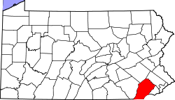
Location of Chester Springs in Pennsylvania
Usa edcp location map.svg
Red pog.svg
Chester Springs
Chester Springs (the United States)
Coordinates: 40°05′42″N75°37′01″W / 40.09500°N 75.61694°W / 40.09500; -75.61694
CountryUnited States
StatePennsylvania
County Chester
Township West Pikeland
Elevation
256 ft (78 m)
Population
 (2000)
  Total7,520
Time zone UTC-5 (EST)
  Summer (DST) UTC-4 (EDT)
ZIP Code
19425
Area code(s) 610
DesignatedMay 13, 1948 [1]

Chester Springs is an unincorporated community in Chester County, Pennsylvania, United States. It is centered on West Pikeland Township, and extends into Charlestown Township, Upper Uwchlan Township, Wallace Township, East Nantmeal Township, and West Vincent Township. The Chester Springs Historic District is located in Chester Springs.

Contents

Demographics

The Chester Springs postal zone is considerably larger than Chester Springs village. As of the 2000 census, the population of Chester Springs ZIP Code Tabulation Area (19425) was 7,520.

Arts and culture

The Historic Yellow Springs Village is located in Chester Springs. The community includes historic churches, established in the 1770s by German Reformed and Lutheran members. These include two facilities on Clover Mill Road: St. Peter's United Church of Christ, whose current building was constructed in 1835, had its first worship place built by its early German Reformed congregation in 1772. St. Peter's Evangelical Lutheran Church was planted by Heinrich Melchior Muhlenberg. Chester Springs is also home to The Mill at Anselma (Lightfoot Mill), a National Historic Landmark grain mill built in 1747. [2] The Mill at Anselma is considered the best-preserved example of a grain mill of its kind in the country, boasting its original wooden gearing system and millstones. It is fully functional today and continues to mill flour and cornmeal for sale. The historic Larkin Covered Bridge, built in 1881, is located near the village of Eagle.

Education

Chester Springs principally lies within the Downingtown Area School District. Some areas of Chester Springs are in the Downingtown Area School District, Great Valley School District, Phoenixville Area School District, and Owen J. Roberts School District. The Chester Springs post office is located on Pennsylvania Route 113 near the heart of the village.[ citation needed ] Chester Springs is also home to Montgomery School, a preschool through 8th grade independent school.

Notable people

Related Research Articles

<span class="mw-page-title-main">Chester County, Pennsylvania</span> County in Pennsylvania, United States

Chester County, colloquially referred to as Chesco, is a county in the Commonwealth of Pennsylvania. It is located in the Delaware Valley region, located in the southeastern part of the state. As of the 2020 census, the population was 534,413, increasing by 7.1% from 498,886 in 2010. The county seat is the Borough of West Chester. The most populous of its 73 municipalities is Tredyffrin Township. The most populous boroughs are West Chester and Phoenixville. Coatesville is the only municipality in the County organized under the City form of government, a technical rather than demographic distinction. Chester County was one of the three original Pennsylvania counties created by William Penn in 1682. It was named for Chester, England.

<span class="mw-page-title-main">Caln Township, Pennsylvania</span> Township in Pennsylvania, United States

Caln Township is a township in Chester County, Pennsylvania, United States. The population was 14,428 at the 2020 census. The township was founded by settlers from Calne, Wiltshire in England in 1714; the relationship between Calne and Wiltshire continues in the present since the two are sister cities. Caln is a township of the First Class, and the governing body is a Board of Commissioners. The township also owns Ingleside Golf Club and over 200 acres (0.81 km2) of green space and parks.

<span class="mw-page-title-main">Downingtown, Pennsylvania</span> Borough in Pennsylvania, United States

Downingtown is a borough in Chester County, Pennsylvania, United States, 33 miles (53 km) west of Philadelphia. As of the 2020 census, it had a population of 7,898. Downingtown was settled by European colonists in the early 18th century and has a number of historic buildings and structures.

<span class="mw-page-title-main">East Bradford Township, Pennsylvania</span> Township in Pennsylvania, United States

East Bradford Township is a township in Chester County, Pennsylvania, United States. The population was 10,308 at the 2020 census.

<span class="mw-page-title-main">East Brandywine Township, Pennsylvania</span> Township in Pennsylvania, United States

East Brandywine Township is a township in Chester County, Pennsylvania, United States. The population was 9,746 at the 2020 census.

<span class="mw-page-title-main">East Pikeland Township, Pennsylvania</span> Township in Pennsylvania, United States

East Pikeland Township is a township in Chester County, Pennsylvania, United States. The population was 7,079 at the 2010 census.

<span class="mw-page-title-main">Exton, Pennsylvania</span> Census-designated place in Pennsylvania, United States

Exton is a census-designated place (CDP) in West Whiteland Township in Chester County, Pennsylvania, United States. Its population was 5,622 at the 2020 census. The Exton Square Mall and Main Street at Exton are both located within Exton along with several other shopping centers, making Exton the major shopping district in Chester County.

<span class="mw-page-title-main">Upper Uwchlan Township, Pennsylvania</span> Township in Pennsylvania, United States

Upper Uwchlan Township is a township in Chester County, Pennsylvania, United States. The population was 11,227 at the 2010 census. The township included the community of Milford Mills before it was inundated by the creation of the Marsh Creek Dam in 1972.

<span class="mw-page-title-main">Uwchlan Township, Pennsylvania</span> Township in Pennsylvania, United States

Uwchlan Township is a township in Chester County, Pennsylvania, United States. The population was 19,161 at the 2020 census.

<span class="mw-page-title-main">West Pikeland Township, Pennsylvania</span> Township in Pennsylvania, United States

West Pikeland Township is a township in Chester County, Pennsylvania, United States. The population was 4,024 at the 2010 census.

<span class="mw-page-title-main">Concord Township, Delaware County, Pennsylvania</span> Township in Pennsylvania, United States

Concord Township is a township in Delaware County, Pennsylvania, United States. The population was 17,231 at the 2010 census. It contains the unincorporated communities of Concordville and Glen Mills.

<span class="mw-page-title-main">South Whitehall Township, Pennsylvania</span> Township in Pennsylvania, United States

South Whitehall Township is a township in Lehigh County, Pennsylvania. The township's population was 19,180 at the 2010 census. It is a suburb of Allentown and is part of the Lehigh Valley, which had a population of 861,899 and was the 68th-most populous metropolitan area in the U.S. as of the 2020 census.

<span class="mw-page-title-main">Brandywine Creek (Christina River tributary)</span> Creek in Pennsylvania and Delaware, US

Brandywine Creek is a tributary of the Christina River in southeastern Pennsylvania and northern Delaware in the United States. The Lower Brandywine is 20.4 miles (32.8 km) long and is a designated Pennsylvania Scenic River with several tributary streams. The East Branch and West Branch of the creek originate within 2 miles (3 km) of each other on the slopes of Welsh Mountain in Honey Brook Township, Pennsylvania, about 20 miles (32 km) northwest of their confluence.

<span class="mw-page-title-main">Glen Mills, Pennsylvania</span> Unincorporated community in Pennsylvania, United States

Glen Mills is an unincorporated community in Concord Township, Delaware County, Pennsylvania, United States, located approximately 27 miles west of Philadelphia. The ZIP Code for Glen Mills is 19342.

<span class="mw-page-title-main">Lightfoot Mill</span> United States historic place

The Mill at Anselma is an archetypal small, 18th century custom grain mill in Anselma, outside Chester Springs, Pennsylvania. It is probably the only surviving one in the United States with an intact colonial-era power transmission system. A custom grain mill typically ground cornmeal and flour only for local farmers, not for commercial distribution. It was designated a National Historic Landmark in 2005.

<span class="mw-page-title-main">Yellow Springs, Chester County, Pennsylvania</span> Unincorporated community in Pennsylvania, United States

Yellow Springs is a historic village in West Pikeland Township in Chester County, Pennsylvania, United States. It is located between Phoenixville and Downingtown.

<span class="mw-page-title-main">Okehocking Historic District</span> Historic district in Pennsylvania, United States

Okehocking Historic District, also known as the Okehocking Indian Land Grant Historic District, is a national historic district in Willistown Township, Chester County, Pennsylvania. It was listed on the National Register of Historic Places in 1993.

<span class="mw-page-title-main">Charlestown Village Historic District</span> Historic district in Pennsylvania, United States

Charlestown Village Historic District is a national historic district located in Charlestown Township, Chester County, Pennsylvania. It is adjacent to the Middle Pickering Rural Historic District. It encompasses 21 contributing buildings and 1 contributing structure on 7 properties in the crossroads village of Charlestown. They date between about 1740 and 1870, and are reflective of a number of popular architectural styles including Late Victorian and Italianate. The oldest is the Job Harvey House, built about 1740. Also included is the Charlestown Woolen Mill (1862-1865), William Nixon House, Charlestown Methodist Episcopal Church, Moses King House, William Howard house and wheelwright shop, and the "Town Hall."

<span class="mw-page-title-main">Middle Pickering Rural Historic District</span> Historic district in Pennsylvania, United States

The Middle Pickering Rural Historic District also known as the Pickering & Pigeon Run Rural Historic District, is a national historic district that is located in Charlestown Township, East Pikeland Township, and West Pikeland Township, Chester County, Pennsylvania.

<span class="mw-page-title-main">Lionville Historic District</span> Historic district in Pennsylvania, United States

The Lionville Historic District is a national historic district that is located in Uwchlan Township, Chester County, Pennsylvania, United States.

References

  1. "PHMC Historical Markers Search". Pennsylvania Historical and Museum Commission. Commonwealth of Pennsylvania. Archived from the original (Searchable database) on March 21, 2016. Retrieved January 25, 2014.
  2. "The Mill at Anselma". National Historic Landmark summary listing. National Park Service. Archived from the original on June 6, 2011. Retrieved February 8, 2008.
  3. "Matt Campanale". NHL.com. Retrieved November 13, 2020.