Pughtown, Pennsylvania

Last updated
Pughtown, Pennsylvania
Chester County Pennsylvania incorporated and unincorporated areas Pughtown highlighted.svg
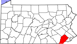
Location in Chester County and the U.S. state of Pennsylvania
USA Pennsylvania location map.svg
Red pog.svg
Pughtown
Location within the state of Pennsylvania
Coordinates: 40°10′00″N75°39′56″W / 40.16667°N 75.66556°W / 40.16667; -75.66556 Coordinates: 40°10′00″N75°39′56″W / 40.16667°N 75.66556°W / 40.16667; -75.66556
Country United States
State Pennsylvania
County Chester
Township South Coventry
Area
[1]
  Total0.45 sq mi (1.16 km2)
  Land0.45 sq mi (1.16 km2)
  Water0.00 sq mi (0.01 km2)
Population
 (2020) [2]
  Total849
  Density1,899.33/sq mi (733.27/km2)
Time zone UTC-5 (Eastern (EST))
  Summer (DST) UTC-4 (EDT)
FIPS code 42-62872

Pughtown is an unincorporated community and census-designated place in Chester County, Pennsylvania, United States. The community is located in South Coventry Township on Pennsylvania Route 100, just south of Buckstown. As of 2020, the CDP has a population of 849. [3]

Contents

Demographics

Historical population
CensusPop.Note
2020 849
U.S. Decennial Census [4] [5]

Education

The community is in the Owen J. Roberts School District. [6] Owen J. Roberts High School is the zoned comprehensive high school.

See also

Related Research Articles

<span class="mw-page-title-main">Chester County, Pennsylvania</span> County in Pennsylvania, United States

Chester County, colloquially known as Chesco, is a county in the Commonwealth of Pennsylvania. It is located in the Delaware Valley region, located in the southeastern part of the state. As of the 2020 census, the population was 534,413, increasing by 7.1% from 498,886 in 2010. The county seat and most populated municipality is West Chester. Chester County was one of the three original Pennsylvania counties created by William Penn in 1682. It was named for Chester, England.

<span class="mw-page-title-main">Chesterbrook, Pennsylvania</span> Census-designated place in Pennsylvania, United States

Chesterbrook is a census-designated place (CDP) in Chester County, Pennsylvania. It is located within the Philadelphia metropolitan area and just south of Valley Forge National Historical Park. The population was 4,589 at the 2010 census.

<span class="mw-page-title-main">East Coventry Township, Chester County, Pennsylvania</span> Township in Pennsylvania, United States

East Coventry Township is a township in Chester County, Pennsylvania, United States. The population was 7,068 at the 2020 census.

<span class="mw-page-title-main">Exton, Pennsylvania</span> Census-designated place in Pennsylvania, United States

Exton is a census-designated place (CDP) in West Whiteland Township in Chester County, Pennsylvania, United States. Its population was 5,622 at the 2020 census. The Exton Square Mall and Main Street at Exton are both located within Exton along with several other shopping centers, making Exton the major shopping district in Chester County.

<span class="mw-page-title-main">Honey Brook, Pennsylvania</span> Borough in Pennsylvania, United States

Honey Brook is a borough in Chester County, Pennsylvania, United States. The population of the borough was 1,895 at the 2020 census. The borough is surrounded by Honey Brook Township, and both are referred to locally collectively as Honey Brook.

<span class="mw-page-title-main">Kenilworth, Pennsylvania</span> Census-designated place in Pennsylvania, United States

Kenilworth is a census-designated place (CDP) in North Coventry Township, Chester County, Pennsylvania, United States. The population was 2,148 at the 2020 census.

<span class="mw-page-title-main">Lionville, Pennsylvania</span> Census-designated place in Pennsylvania, United States

Lionville is a census-designated place (CDP) in Uwchlan Township, Chester County, Pennsylvania, United States. The population was 6,189 at the 2010 census. Prior to 2010 the CDP was recorded as Lionville-Marchwood. "Marchwood", however, refers only to the housing development begun in the early 1960s that is located south of the 100-113 intersection.

<span class="mw-page-title-main">North Coventry Township, Chester County, Pennsylvania</span> Township in Pennsylvania, United States

North Coventry Township is a township in Chester County, Pennsylvania, United States. The population was 7,866 at the 2010 census.

<span class="mw-page-title-main">South Coventry Township, Chester County, Pennsylvania</span> Township in Pennsylvania, United States

South Coventry Township is a township in Chester County, Pennsylvania, United States. The population was 2,604 at the 2010 census.

<span class="mw-page-title-main">South Pottstown, Pennsylvania</span> Census-designated place in Pennsylvania, United States

South Pottstown is a community in North Coventry Township, Chester County in the U.S. state of Pennsylvania. It is defined by the U.S. Census Bureau as a census-designated place (CDP) for statistical purposes and does not have any legal status as a separately incorporated municipality. It is a part of the Pottstown urban area. The population was 2,081 at the 2010 census.

<span class="mw-page-title-main">Warwick Township, Chester County, Pennsylvania</span> Township in Pennsylvania, United States

Warwick Township is a township in Chester County, Pennsylvania, United States. The population was 2,507 at the 2010 census.

<span class="mw-page-title-main">West Chester, Pennsylvania</span> Borough in Pennsylvania, United States

West Chester is a borough and the county seat of Chester County, Pennsylvania, United States. Located within the Philadelphia metropolitan area, the borough had a population of 18,461 at the 2010 census. West Chester is the mailing address for most of its neighboring townships. When calculated by mailing address, the population as of the 2010 U.S. Census was 108,696, which would make it the 10th largest city by mailing address in the state of Pennsylvania.

<span class="mw-page-title-main">West Vincent Township, Chester County, Pennsylvania</span> Township in Pennsylvania, United States

West Vincent Township is a township in Chester County, Pennsylvania. The population was 4,567 at the 2010 census.

<span class="mw-page-title-main">Pottstown, Pennsylvania</span> Borough in Pennsylvania, United States

Pottstown is a borough in Montgomery County, Pennsylvania, United States. Pottstown was laid out in 1752–53 and named Pottsgrove in honor of its founder, John Potts. The old name was abandoned at the time of the incorporation as a borough in 1815. In 1888, the limits of the borough were considerably extended. Pottstown is the center of a productive farming and dairying region.

<span class="mw-page-title-main">Unionville, Chester County, Pennsylvania</span> Census-designated place in Pennsylvania, United States

Unionville is an unincorporated community and census-designated place in East Marlborough Township in southern Chester County, Pennsylvania, United States. It was originally known as Jacksonville. The Unionville Village Historic District was added to the National Register of Historic Places in 1979. As of 2020, the CDP has a population of 577.

The Owen J. Roberts School District is a school district located in northern Chester County, Pennsylvania. its headquarters are in South Coventry Township, with a Pottstown postal address.

<span class="mw-page-title-main">Gibraltar, Pennsylvania</span> Census-designated place in Pennsylvania, United States

Gibraltar is a census-designated place (CDP) in northern Robeson Township in southern Berks County, Pennsylvania, United States. Its population was 680 as of the 2010 census. The community is four miles from Birdsboro and 6.4 miles from downtown Reading. It is served by the Twin Valley School District and is across the Schuylkill River from Exeter.

<span class="mw-page-title-main">Hayti, Pennsylvania</span> Place in Pennsylvania, United States

Hayti is a census designated place and unincorporated community situated in Valley Township in Chester County, Pennsylvania, United States. The CDP was first designated as such in 2020. As of 2020, it has a population of 2,890. Hayti has an estimated elevation of 502 feet (153 m) above sea level.

Owen J. Roberts High School is a high school in the Owen J. Roberts School District. It is located in Bucktown, in South Coventry Township, Chester County, Pennsylvania, in the Philadelphia metropolitan area. It has a Pottstown postal address.

<span class="mw-page-title-main">Dilworthtown, Pennsylvania</span> Census-designated place in Pennsylvania, United States

Dilworthtown is an unincorporated community and census-designated place (CDP) in Chester and Delaware counties, Pennsylvania, United States. It was first listed as a CDP prior to the 2020 census.

References

  1. "ArcGIS REST Services Directory". United States Census Bureau. Retrieved October 16, 2022.
  2. "Census Population API". United States Census Bureau. Retrieved Oct 12, 2022.
  3. "Census Population API". United States Census Bureau.
  4. "Census of Population and Housing". Census.gov. Retrieved June 4, 2016.
  5. "Census Population API". United States Census Bureau. Retrieved Oct 15, 2022.
  6. "2020 CENSUS - SCHOOL DISTRICT REFERENCE MAP: Chester County, PA" (PDF). U.S. Census Bureau . Retrieved 2022-10-19.